


Baltic Forest Hiking - Dream tour

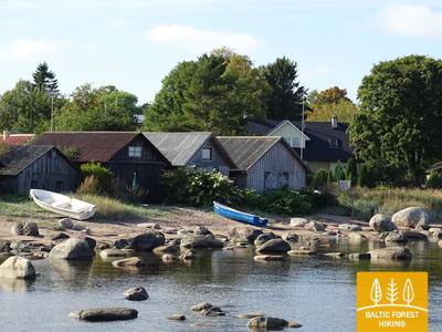
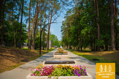
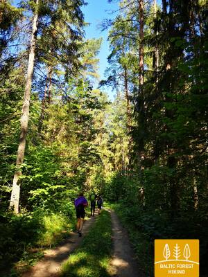
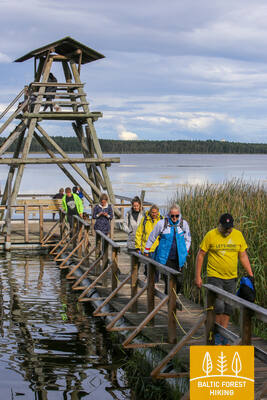
 4-й этап. Рамкални – Сигулда.
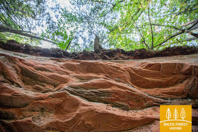
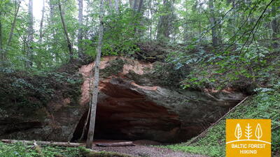
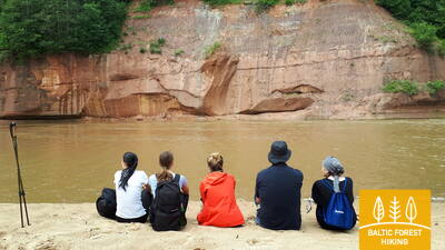
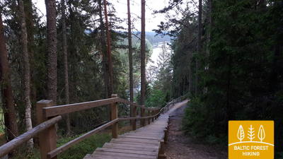
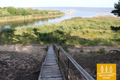
Красивейшие виды древнего русла Гауи возле Сигулды
Покинув парк Рамкални, Лесная тропа поднимается на высокий, крутой склон древней долины Гауи, проходит через поселок Гауя и устремляется вниз. Далее тропа пересекает речку Лорупе, проходит по изгибам Гауи и приводит к одному из самых впечатляющих береговых обнажений на Гауе – утесу Чертовой пещеры. Затем тропа ведет к таким достопримечательностям как Кейзарскатс, делает круг до Кейзаркреслса, Межакакиса на горе Какишкалнс, Сигулдской санно-бобслейной трассы и достигает центра Сигулды.

Часть Лесной тропы, покрытая лесами и переплетенная небольшими дорогами или тропинками, предлагает вид на впечатляющую долину реки Гауя около Сигулды. Лесная тропа пересекает Национальный парк Гауя по всей своей длине (с юго-запада на северо-восток).
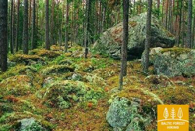
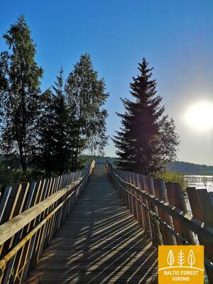
5-й этап. Сигулда – Лигатне.
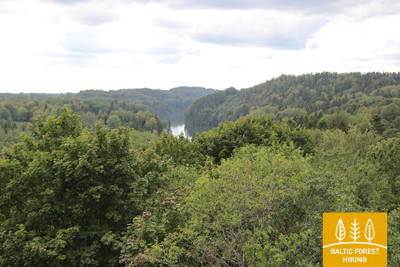
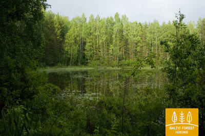
В самом сердце Национального парка Гауя
Сделав круг через Сигулду, Лесная тропа по верхней части склона оврага Вейупите приводит путников к горе Парадизес, затем спускается по крутой лестнице к древней долине Гауи и оврагу Вейупите. Основную часть дальнейшего этапа составляют небольшие одинокие тропинки, ведущие через лес и луга (на которых в июне цветет смолка). Далее Лесная тропа пересекает ущелья многих небольших рек, на склонах которых виднеются обнажения песчаника. Последние шесть километров этапа – природные тропы Лигатне. На подступах к городу Лигатне Лесная тропа поднимается по склону древней долины Гауи, а в Лигатне спускается в глубокий овраг реки Лигатне, на склонах которого находится поселок бывшей бумажной фабрики.
Один из самых красивых участков Национального парка Гауя, откуда открывается вид на песчаниковые обнажения долины реки Гауя и ее притоков. Лигатне является памятником индустриального наследия. Лесная тропа пересекает Национальный парк Гауя по всей его длине (с юго-запада на северо-восток).
 6-й этап. Лигатне – Цесис.
По старой цесисской дороге через долину реки Амата
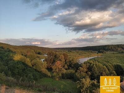
Один из самых живописных участков Лесной тропы проходит через исторический поселок бумажной фабрики Лигатне, мимо геологического обнажения Сприньгю, по извилистым тропинкам Скальупе и Мифологической тропе. Заглянув в Советский бункер (один из секретных объектов периода Железного занавеса), Лесная тропа доходит до заповедника Рочу, пересекает реку Амата, по геологической тропе (самый красивый и скалистый участок у берегов Аматы) приводит к геологическому образованию Звартес. Далее Лесная тропа устремляется на высокий склон долины Аматы и по исторической дороге (ранее столбовая дорога Цесис – Рига, ныне небольшая проселочная и лесная дорога со старыми дорожными столбами) приводит в Ракши. Далее Тропа поднимается на холм Валюкалнс и из Озолкалнса идет по извилистым природным тропам Цирулиши, вдоль берегов Гауи, где находится множество родников и отложений песчаника. Этап завершается на улице Гауяс, по которой путешественники, преодолев 2,8 км, могут дойти до Старого города, провести день в Цесисе и продолжить путь.
На этом участке Лесная тропа вьется по впечатляющей долине реки Гауя, пересекая также глубокие долины других рек, таких как Амата. Вдоль берегов Аматы Лесная тропа совпадает с Геологической тропой Аматы, ведущей к утесу Звартес — одному из самых популярных туристических объектов в Латвии, с которого открываются потрясающие виды на речную долину. Возле Цесиса Лесная тропа совпадает с участком тропы Цирулиши. Лесная тропа пересекает Национальный парк Гауя по всей своей длине (с юго-запада на северо-восток).
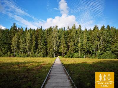
7-й этап. Цесис – Цаунитес.
Впечатляющие обнажения песчаника на берегах Гауи
К базе водного туризма Ленчи Лесная тропа проходит по небольшим дорогам и тропам, пролегающим в лесу, вдоль излучины Гауи и древних речных долин. Не доходя до скал Эргелю, Лесная тропа сливается с выразительным рельефом местности, поднимается и спускается по склонам древней долины Гауи, изборожденной небольшими ручьями. Миновав скалы Эргелю, Лесная тропа слегка отклоняется в сторону Цесиса, в Пиешкални делает поворот в направлении Рамниеки, где пересекает мост через Гаую. Оставив позади базу водного туризма Яньрамис, Лесная тропа, будто стремясь оправдать свое название, устремляется в светлохвойный лес. Затем тропа приводит путников в Цаунитес, где находится одно из красивейших мест отдыха на берегах Гауи.
На этом участке Лесная тропа проходит от скал Эргелю вдоль берегов впечатляющей долины реки Гауя через красивые хвойные леса. От моста Рамниеки до Валмиеры она совпадает с велосипедным маршрутом «Цесис - Валмиера». Лесная тропа пересекает Национальный парк Гауя по всей своей длине (с юго-запада на северо-восток).
 8-й этап. Цаунитес – Валмиера.
По дороге в «Зеленый город» – Валмиеру
Покинув Цаунитес, Лесная тропа уводит в сосновые боры, смешанные леса, богатые мхом и травянистыми растениями, поднимается на склоны и холмы или огибает их. С утеса Сиетиньиезис открывается один из самых красивых видов на Гаую. Здесь же находится природная тропа Сиетиньиезис, которая заслуживает того, чтобы прогуляться по ней. Дальнейший путь, вплоть до границы Валмиеры, ведет через леса и мимо небольших хуторов. Миновав Валмиерскую окружную дорогу, Лесная тропа ведет по городским тротуарам Валмиеры. На завершающем участке, от «Железки» (бывший узкоколейный железнодорожный мост) до улицы Цесу, Лесная тропа ведет по небольшим тропам и обочинам, окруженным деревьями.
Участок Лесной тропы с красивыми и живописными сосновыми лесами, покрывающими берега долины реки Гауя. От моста Рамниеки до Валмиеры Лесная тропа совпадает с велосипедным маршрутом «Цесис - Валмиера». Лесная тропа пересекает Национальный парк Гауя по всей своей длине (с юго-запада на северо-восток).
15-й этап. Апе – Паганамаа – Корнети – латвийско-эстонская граница.
Через рытвину Корнети-Пелли и Паганамаа (Чертову землю)
Покинув Апе, Лесная тропа первые километры проходит по холмистым сельскохозяйственным угодьям, затем проходит через большой лесной массив, прерываемый зеркальной гладью многочисленных больших и малых озер. Миновав Пелли, Лесная тропа ведет по тропе Пелли, переходит латвийско-эстонскую границу и проделывает 2 км вдоль озер Смилшайс, Сунеклис и Илгайс. Эта местность именуется Паганамаа (с эстонского – Чертова земля). Здесь Лесная тропа спускается в субгляциальную рытвину Корнети-Пелли, которая считается одним из крупнейших оврагов в Латвии. Возле озера Илгайс Лесная тропа возвращается в Латвию и по весьма холмистой местности приводит к городищу Друску, на которое ведет крутая тропа. В Корнети Лесная тропа делает спуск. От центра Корнети до латвийско-эстонской границы менее 3 км. С дороги отрываются прекрасные виды на побережье озер Большой и Малый Балтиньш. Этап находится на территории охраняемых ландшафтов Вецлайцене.
Один из самых красивых участков Лесной тропы на севере Латвии пересекает часть Алуксненской возвышенности и ледниковую впадину Корнети-Пелли, открывая потрясающие холмистые и озерные пейзажи, которыми можно любоваться со смотровых башен. Апе — живописный латвийский городок, известный своими характерными малоэтажными зданиями из доломита и мощеными улочками.
19-й этап. Вана-Вастселийна (Vana-Vastseliina) – Колодавитса.
Вдоль берегов Пиузы (Piusa), самой быстрой реки Эстонии
Первая треть этапа проходит по тропам долины реки Пиузы. Возле села Хярма (Härma) Лесная тропа поворачивает к селу Обинитса, которое является важным центром культуры региона Сетомаа (Setomaa). Здесь можно ознакомиться с традициями народности сету. За селом Обинитса Лесная тропа снова погружается в прекрасные, поросшие вереском сосновые леса, еще раз спускается в глубокую долину реки Пиуза и возле пещер Пиузы поворачивает на восток. Далее Лесная тропа проходит склону речной долины Пиузы и достигает следующего ориентира – автодороги и железнодорожной линии, находящейся недалеко от станции Койдула.
Необычайно живописный, покрытый лесом участок реки Пиуза с прекрасными выходами песчаника и культурное пространство народа сету с его живыми традициями делают этот участок лесной тропы одним из самых интересных в Южной Эстонии.
26-й этап. Варнья (Varnja) – Алатскиви.
В гостях у луководов Причудья
Путь Лесной тропы походит по живописной местности, богатой традициями. Одна из них – выращивание лука. Традицию выращивания лука заложили староверы, поселившиеся в этих краях в 17-м веке. Визитной карточкой региона стало изображение женщины и мужчины, продающих у дороги гирлянды из лука. 24-километровый участок Варнья – Калласте, пролегающий вдоль побережья Чудского озера, получил название «Луковый путь». Туристы, совершающие прогулку по этому этапу, любуются разноцветными деревянными домами, заглядывают в рыбные магазинчики и ресторан, где можно попробовать чай из самовара по традициям чаепития староверов. Круглогодично здесь предлагаются блюда из ряпушки (по-эстонски – rääbis), выловленной в Чудском озере.
Исключительно живописный участок Лесной тропы, богатый памятниками культуры и отражающий местные традиции, в основном петляет вдоль берегов Чудского озера, соединяя старообрядческие деревни.
31-й этап. Лохусуу – Куру.
По северному берегу Чудского озера, через грибные и ягодные леса
Первая половина этого этапа проходит через сосновые леса, особенно в ландшафтном заповеднике Ярвевялья (Järvevälja). На территории заповедника Лесную тропу с севера окаймляют дюны, с юга – верховое болото. В Раннапунгерья (Rannapungerja) стоит сделать остановку, чтобы купить в киоске копченую рыбу (ряпушку, выловленную в Чудском озере; по-эстонски – rääbis) и сельскохозяйственную продукцию. Далее Лесная тропа ведет по автодорожному мосту через реку Раннапунгерья и возле Каукси выходит на берег Чудского озера. Здесь можно сделать привал, чтобы отдохнуть и отведать купленную рыбу. На следующий день Лесная тропа продолжает свой путь по берегу Чудского озера, напоминающему морской пляж с прекрасными покрытыми соснами дюнами.
Красивые сосновые леса и болота, а также необычайно живописные берега Чудского озера, чьи песчаные пляжи с высокими песчаными дюнами больше напоминают морское побережье, чем берег озера. Это подходящее место для прогулок и походов различной продолжительности в зависимости от ваших возможностей. Берег Чудского озера чередуется с небольшими поселениями, где доступны различные услуги.
34-й этап. Куремяэ (Kuremäe) – Васавере.
По ландшафтному заповеднику Куртна
Оставив позади холм с монастырем Куремяэ, Лесная тропа пересекает невероятно живописный ландшафтный заповедник Куртна (входит в состав национального парка Алутагузе (Alutaguse)). Здесь среди светлохвойных лесов раскинулись многочисленные голубые озера. Эта территория, вместившая 42 озера, отличается самой большой в Эстонии плотностью их расположения. В наиболее сырых местах проложены деревянные мостки, через канавы и речки ведут деревянные мостики. В окрестностях центра спорта и отдыха Алутагузе созданы тропы для пеших прогулок и скандинавской ходьбы.
Исключительно живописный участок Лесной тропы, проходящий через часть национального парка Алутагузе и ландшафтный заповедник Куртна, богатый ледниковыми холмами, среди которых расположено множество озер. В этом районе самая высокая плотность озер в Эстонии.
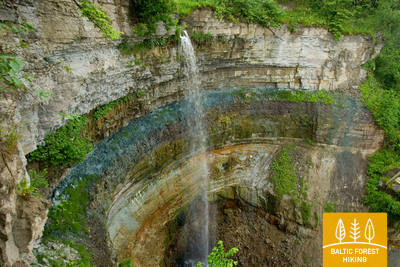
36-й этап. Тойла – Сака.
Живописная часть Северо-Эстонского глинта между Тойла и Сака.
Это один из самых необычных этапов Лесной тропы в Северной Эстонии. При благоприятных погодных условиях Лесная тропа приглашает пройти у подножия Северо-Эстонского глинта. Возле поселков Валасте и Сака тропа уводит на вершину глинта, открывая прекрасные виды на Финский залив с подъема Виру. На участке Сака – Онтика – Тойла (протяженность около 23 км) высота Северо-Эстонского глинта достигает 55 м. В ясную погоду с края Северо-Эстонского глинта можно видеть удаленные на 50 км острова Суур-Тютарсаар и Вяйке-Тютарсаар (Suur Tütarsaar; Väike Tütarsaar), находящиеся на в российских территориальных водах.
Один из самых живописных участков Северо-Эстонского Глинта, где Лесная тропа ведет как по его подножию, так и по вершине с фантастическими видами, особенно на водопад Валасте и другие.
41-й этап. Эйсма – Оанду.
По тропам Национального парка Лахемаа
Покинув поселок Вайнупеа, Лесная тропа направляется в Лахемаа (Lahemaa, в переводе с эстонского – «Земля залива») – первый национальный парк Эстонии. В течение пяти с половиной дней Лесная тропа знакомит путников с испещренной полуостровами и бухтами прибрежной территорией Национального парка, его наиболее значительными природными и культурно-историческими ценностями. В Национальном парке необходимо соблюдать правила внутреннего распорядка. В этот день Лесная тропа ведет по красивым и тихим прибрежным лесам, где осенью в изобилии растут грибы. Далее тропа пересекает живописный поселок Алтья. В Оанду, конечном пункте этапа, находится Гостевой центр Управления государственными лесами Эстонии (RMK), где можно получить информацию о лесных биотопах и традициях хозяйственного управления лесом.
Очень красивая, покрытая лесом прибрежная часть национального парка Лахемаа с двумя небольшими рыбацкими деревнями - Вайнупеа и Алтья. Лесная тропа в основном идет по небольшим лесным дорогам.
42-й этап. Оанду – Кясму (Käsmu).
Кясму – поселок капитанов и строительства парусников
На участке от Оанду до Вызу (Võsu) Лесная тропа проходит 9 км по территории внутриматериковых, поросших лесом дюн. На некоторых соснах можно видеть надрезы, оставленные сборщиками смолы. В странах Балтии смолу таким способом добывали вплоть до 60-70-х годов 20-го века. Деревья густо покрыты лишайником, что свидетельствует о чистоте воздуха. Осенью вдоль тропы растут грибы и черника. Заглянув в Вызу (популярный курорт), Лесная тропа по прекрасному прибережному лесному променаду приводит в поселок Кясму. Стоит пройти один километр, чтобы посмотреть на камни Вана-Йюри (Vana-Jüri), находящиеся на краю полуострова, а также совершить прогулку по историческим местам Кясму.
Живописно разнообразная часть национального парка Лахемаа, где можно увидеть леса, сформированные на дюнных гребнях, и побережье Лахемаа, богатое заливами и впечатляющими валунами. Рыбацкая деревня Кясму интересна своей малоэтажной деревянной архитектурой, где во дворе каждого дома есть большой камень. Это одно из самых красивых мест на побережье Эстонии
43-й этап. Кясму (Käsmu) – Вийнисту (Viinistu).
В царстве валунов полуострова Кясму
Первая треть этого этапа Лесной тропы проходит через полуостров Кясму, сказочное место с лесистыми дюнами и заросшими мхом валунами. Возле поселка Эру Лесная тропа преодолевает 2-километровый участок дороги Вызу (Võsu) – Котка, проходит через поселок Вихасоо и выводит на обочину дороги, откуда можно видеть залив Эру и полуостров Кясму. На этом этапе перед путниками предстают величественные ледниковые, входящие в число крупнейших в Национальном парке Лахемаа, – Таммиспеа и Яаани-Тоома Сууркиви (Jaani-Tooma Suurkivi), напоминающие обломки огромной скалы. С побережья в районе Вийнисту хорошо виден остров Мохни с маяком.
Исключительно живописный участок Лесной тропы на полуострове Кясму, где есть небольшие тропинки, ведущие через прибрежные леса, покрытые мшистыми камнями. Не менее интересны и небольшие прибрежные деревни с узкими улочками и камнями между зданиями и дворами. В деревне Таммиспеа вы можете увидеть один из самых впечатляющих валунов Эстонии. Он является частью территории национального парка Лахемаа.
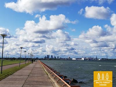
50-й этап. Пююнси (Püünsi) – Таллинн.
Самые красивые виды на Старый Таллинн
Лесная тропа проходит вдоль побережья Таллиннского залива, где в Пююнси открывается вид на башни Старого города, высотные здания и порт Таллинна. Приближаясь к Пирита (Pirita), Лесная тропа уводит в очаровательный сосновый лес, затем 2 километра по песчаному морскому пляжу. Путь от Пирита до Таллинна пролегает по прекрасному городскому променаду, откуда открываются виды на море и порт, а также культурно-исторические объекты. Лесная тропа завершает свой путь в Таллиннском порту, рядом с которым находится Старый город. На осмотр Старого города следует отвести один или два дня.
Этот участок лесной тропы проходит вдоль береговой линии, откуда открывается прекрасный вид на Таллин, порт и Старый город.
52-й этап. Veisiejai – Trikojis.
По Вейсеяйскому региональному парку
Оставив позади центр Вейсеяй, Лесная тропа пересекает проток Вейсеяйского озера, затем по улицам Витауто, Тургаус и Лепалингё (шоссе № 134) выходит на берег озера Снайгинас, где расположена обзорная башня и площадки для отдыха. После пересечения небольшого лесного массива возле Вейсеяй, Лесная тропа на протяжении 1,4 км пролегает по шоссе Вейсеяй–Барчяй (№ 2529), а затем сворачивает вправо. Далее маршрут проходит по красивейшему сосновому лесу рядом с озером Анча, окрестности которого славятся обилием грибов и ягод. Повернув на восток, Лесная тропа с южной стороны приближается к деревне Барчяй. Затем через засеянные хлебными злаками поля выводит к озеру Трикойис. Возле бухты озера Трикойис Лесная тропа пересекает лесистые площади, постоянно приближаясь к шоссе № 2517. Данный этап Лесной тропы находится на территории Вейсеяйского регионального парка.
Живописный и лесистый регион нагорья Судава с озерами, смотровой башней и широкими возможностями для исследования и отдыха, включая купание в чистых водах озера. Большая часть участка Лесной тропы вьется по небольшим тропам или небольшим дорогам.
54-й этап. Didžiasalis – Druskininkai – Žiogeliai.
Друскининкай – самый популярный курорт в Восточной Литве
Между деревней Диджясалис и курортом Друскининкай Лесная тропа петляет по хвойным лесам, отличающимся обилием ягод и грибов. Возле Друскининкай Лесная тропа совпадает с маршрутом вдоль реки Неман, огибает комплекс зимних развлечений Сноу Арена в Друскининкай, а затем по пешеходным и велосипедным дорожкам выходит к Парковому мосту через реку Неман. Миновав мост, Лесная тропа пролегает по улице Майронё и далее по небольшим улочкам и парковым аллеям исторического курорта Друскининкай, пересекает небольшую реку Ратнича и лесопарк на правом берегу Немана. За улицей Вейсею маршрут проходит по тротуару улицы Нераву и через приблизительно 1 км поворачивает налево на улицу Соджяус, которая на окраине деревни Неравай превращается в живописную лесную дорожку. Это граница Дзукийского национального парка. Лесная тропа огибает деревню Вечюнай, где перед пешими туристами открывается красивейшая панорама Лишкявского монастыря на противоположном берегу реки Неман. Далее до деревни Жиогяляй Лесная тропа пролегает по красивой и спокойной лесной дорожке.
Очень разнообразный участок Лесной тропы, включающий как небольшие тропы, так и небольшие проселочные дороги, а также популярный курорт Друскининкай с широкими возможностями для активного и пассивного отдыха, наслаждения историей, традициями и кулинарным наследием. Заключительная часть участка находится в Дзукийском национальном парке.
55-й этап. Žiogeliai – Merkinė.
Дзукийский национальный парк
До самого устья реки Мяркис, места её слияния с рекой Неман, Лесная тропа пролегает по берегам долины Немана, где в окрестностях Дайнавской равнины её окружают огромные и прекрасные Дзукийские леса. Местами в лесных массивах встречаются открытые участки, на которых разбросаны небольшие деревни. Возле деревни Чесукай Лесная тропа по большой дуге огибает место впадения реки Мяркис в реку Неман, так как ближайший мост расположен на шоссе А4. Здесь открываются впечатляющие виды на широкое и глубокое устье реки Мяркис. После пересечения реки Мяркис, Лесная тропа проходит по узкой сельской дорожке по левому берегу реки и выводит к Мяркинскому городищу, с которого открывается панорама одного из красивейших ландшафтов Восточной Литвы. По узким и извилистым улочкам Мяркине (Пилякалнё, В. Сладкявичяус, С. Даряус и С. Гирено) Лесная тропа приводит в центр городка. Данный этап маршрута проходит по территории Дзукийского национального парка.
Живописный участок Лесной тропы, который в основном вьется вдоль берегов долины Немана и через большие лесные массивы, расположенные в Дзукийском национальном парке.
56-й этап. Merkinė – Nemunaitis.
По долине реки Неман
В Мяркине Лесная тропа по улице Сейню пролегает в направлении реки Неман, сворачивает вправо и останавливается у обзорной башни, с которой открывается изумительный вид на широкую речную долину и остров Нямунас, служащий пастбищем для домашних животных. Далее на протяжении более 3 км Лесная тропа петляет вдоль крутых берегов реки Неман, затем резко поворачивает на север и по небольшим лесным дорожкам в западном направлении выводит к деревне Нятесос и курорту Друскининкай. За Друскининкай тропа пересекает крупнейшую на данном этапе открытую местность, которая подарит вам прекрасные виды. Далее Лесная тропа пролегает по долине Немана, однако сама река на данном участке пока не просматривается. Местами на пути встречаются холмы с крутыми склонами. У деревни Вангелонис Лесная тропа выходит на более открытое пространство, пересекает небольшой лесной массив и по улицам Вангелоню и Саулетякё приводит на главную улицу деревни Нямунайтис. Часть данного этапа от Мяркине до Друскининкай находится на территории Дзукийского национального парка.
Покрытый лесом, одинокий участок Лесной тропы, пролегающий вдоль долины Немана, включающий небольшие поселения и смотровую башню с обширным видом. Первая половина участка является частью Дзукийского национального парка.
69-й этап. Kirkšnovė – Kaulakiai.
По Дубисскому региональному парку
Приблизительно через 0,5 км от Киркшнове Лесная тропа сворачивает налево от шоссе Ариогала–Бетигала (№ 3504) и далее до конечной точки маршрута у шоссе Расейняй–Байсогала (№ 225) повторяет изгибы реки Дубиса, где заливные луга сменяют небольшие лесные массивы и маленькие деревеньки. Местами открываются впечатляющие виды на высокие берега и городища Дубисской долины. На данном этапе особенно чёткий рельеф – Лесная тропа петляет вверх и вниз по береговым откосам, обеспечивая пешим туристам незабываемые впечатления. Это этап для путешественников-гурманов!
Один из самых живописных и разнообразных участков Лесной тропы, богатый достопримечательностями, являющийся частью регионального парка «Дубисская долина».
73-й этап. Dengtiltis – Kurtuvėnai.
По Куртувенайскому региональному парку
Куртувенайский региональный парк – одна из самых лесистых местностей средней части Литвы с чёткими, сформированными ледником формами рельефа, простирающимися по восточной части Жемайтской возвышенности между Вентой и Дубисой. Из Денгтилтиса Лесная тропа по узким лесным дорожкам ведёт на Кельмеское шоссе (№ 2106), немного продвигается в северо-восточном направлении и через 0,4 км поворачивает налево. Затем маршрут петляет по лесным тропа в направлении Пагелувиса и озера Гелува. Описав петлю вокруг озёр Гелува, Барсукинас и Дубукас, Лесная тропа уходит в западном и северо-западном направлении, по виадуку пересекает магистральное шоссе А12 и далее по открытой местности, через небольшие деревни ведёт вдоль водоёма Дамба, затем поворачивает на улицу Ужтванкос. С западной стороны водоёма располагается городок Куртувенай. По главной улице П. Вишинскё Лесная тропа достигает конечной точки этапа.
Один из самых красивых участков Лесной тропы в Жемайтийском крае, где тропа проходит по небольшим лесным дорогам и тропам, среди которых много интересных природных и культурных памятников. Расположен в региональном парке Куртувенай.
74-й этап. Kurtuvėnai – Šaukėnai.
Чудеса природы в Куртувенайском региональном парке
По узким лесным тропинкам и небольшим дорожкам Лесная тропа проходит через Куртувенайский региональный парк, по территории которого проложены познавательные тропы. Миновав Куртувенай, маршрут пролегает по красивой аллее деревьев и приблизительно через 1 км, повернув налево, продолжает петлять между водоёмами для разведения рыбы и небольшими заросшими луговыми растениями холмами, пока снова не исчезнет в лесу. Лесная тропа по дуге огибает деревню Вайнагяй, по деревянным мосткам проводит через водно-болотное угодье и выводит к городищу, с которого открывается панорама озера Вайнагяй. Затем на протяжении 4 км до Шаукенай Лесная тропа петляет по лесной дорожке, а на подходе к городку Шаукенай огибает озеро Юодле по северо-восточному побережью. В городке Шаукенай тропа пролегает по улице Юодлес.
Один из самых красивых участков Лесной тропы в Жемайтийском крае, где тропа проходит по небольшим лесным дорогам и тропам, среди которых много интересных природных и культурных памятников. Расположен в региональном парке Куртувенай.
83-й этап. Paplatelė – Plateliai.
Среди крупнейших озёр Жемайтийского национального парка
Первые 3,5 км Лесная тропа ведёт через красивейшие хвойные леса. До Музея холодной войны тропа совпадает с познавательной тропой Плокштине, а 5 км от музея – с пешеходной и велосипедной дорожкой Плокштине. У шоссе № 3202 (улица Малуно) маршрут сворачивает налево на юго-запад и сразу, через 0,3 км, направо на юго-юго-запад. Приблизительно через 0,5 км выходит на улицу Ильгё эжеро. Затем на протяжении 5,5 км маршрут делает широкий круг вокруг озёр Ильгис и Бержорас, пока не выведет к деревне Бержорас. Через 2 км по улице Плунге Лесная тропа приводит в центр Плателяй и делает ещё один круг по улице Эжеро до познавательной тропы Шейре, открывая живописный ландшафт. Далее по улицам Эжеро, Науёйи и Жямайчю Калвариёс возвращается в центр города.
Участок Лесной тропы полностью находится на территории Жемайтийского национального парка, образуя полукруг вокруг озера Плателяй. Исключительно красивые места с ландшафтами холмов и озер Жемайтийской возвышенности. Здесь есть обширные возможности для отдыха - солнечные ванны, купание, дайвинг, катание на лодках, велосипедах, прогулки, сбор грибов, ягод, наблюдение за природой и наслаждение национальными блюдами. В начале участка можно увидеть бывшую советскую ядерную ракетную базу и экспозицию холодной войны.
95-й этап. Sabile – Kandava.
По одному из самых красивых природных парков Курземе
Лесная тропа проходит по левому берегу Абавы – по ул. Кр.Барона. Далее, переходя в небольшую тропку, она петляет через луга и леса долины старого русла Абавы, пока не достигает холма, называемого Шведской шапкой. За ним небольшая тропа ведёт к дороге Плости - Пуцес (V1471), пересекает Амулу и у Калнмуйжа поднимается на вершину старого русла Абавы, где продолжается 6 км до парка поместья Айздзире. В северном направлении маршрут протяженностью 1 км петляет по долине старого русла Абавы, откуда открываются одни из самых красивых видов на эту долину. Старое русло Абавы в этом месте достигает 40 метровой глубины. За Звейниекским мостом маршрут поднимается по северному берегу старого русла, где растут виноградники. Далее за лесом пересекает дорогу Кандава – Ренда (Р130) и по ул. Сабиле доходит до Кандавы. Улицы этого живописного городка - Лауку, Озола, Зилу, Сабилес и Пилс ведут к Рыцарскому городищу. Маршрут всё время петляет по старому руслу реки Абава.
Древняя долина реки Абавы — одна из самых широких речных долин в Латвии и Курземе, с видами на луга и пастбища на берегах и склонах, небольшими городами, такими как Ренда, Сабиле и Кандава, а также множеством исторических и современных культурных памятников, включая городища, руины средневековых замков, усадьбы и их парки, а также художественный парк Педвале.
99-й этап. Jāņukrogs – Bigauņciems.
По Кемерскому национальному парку
После пересечения территории с несколькими усадьбами, извилистая Лесная тропа проходит через красивые хвойные леса и еще 6,5 км по Чаукциемсу, пока не сворачивает к Зеленой дюне. Дальше идет по обочине дороги Антинциемс - Смарде. Местность ровная, так как маршрут пролегает по равнине Энгуре в прибрежной низменности. С Зеленой дюны открывается широкий вид на болото Заля (Зеленое) и Ведьмино болото. Небольшая извилистая лесная тропа проходит по нижней части дюны и в двух местах пересекает болото по деревянным мосткам. В Кемери маршрут пролегает по улицам партизану, Робежу, А. Упиша, Катедралес и E.Дарзина через информационный центр национального парка «Meža māja“ и Вершупите, в которую втекают воды серных источников. Маршрут пересекает улицу Туристу и дальше идет по дороге Дуну до озера Слокас. Дальше Лесная тропа доходит до болотистого леска Вершупите - одной из самых лучших сред обитания влажных лесов во всем Курземе. Возле озера Мелнэзерс маршрут сворачивает в сторону старой Кемерской дороги и через 2 км достигает Бигаунциемса. За трассой Слока-Талси (P128) маршрут Лесной тропы доходит до Рижского залива и соединяется с маршрутом тропы Балтийского взморья (E9). Весь этап пути Лесная тропа проходит через Кемерский национальный парк (КНП).
На этом участке Лесная тропа пересекает национальный парк Кемери, который был создан в первую очередь для защиты водно-болотных угодий и связанных с ними местообитаний и биоразнообразия. В парке есть несколько природных троп, некоторые из которых совпадают с Лесной тропой. Маршрут включает в себя центр для посетителей парка. Этот участок можно разделить и пройти пешком за два дня.