


Baltic Forest Hiking - Facts
The Forest Trail is a part of the European long-distance hiking route E11.
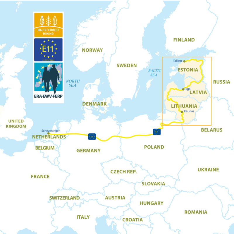
Route E11 takes its start by the North Sea in Scheveningen, in the surroundings of The Hague, the Netherlands, and ends in Tallinn, the capital of Estonia. It passes through six countries — the Netherlands, Germany, Poland, Lithuania, Latvia and Estonia — and cities such as Osnabrück (D), Potsdam (D), Frankfurt an der Oder (D) and Poznan (PL). At Ogrodniki, it crosses the Polish/Lithuanian border.
Name in Lithuania: Miško takas, in Latvia: Mežtaka; in Estonia: Metsa matkarada
Starting point: Polish - Lithuanian border, 7 km south of the town of Lazdijai, Lithuania.
End point: Port of Tallinn in Estonia. The route can be followed in both directions, so you can choose Tallinn as the starting point.
Two capital cities whose old towns have been awarded with the UNESCO World Heritage status: Riga, Tallinn. Kaunas has been approved by UNESCO as a City of Design.
Length: 2141 km
- 747 km in Lithuania
- 674 km in Latvia
- 720 km in Estonia
The Forest Trail passes through Dzūkija and Žemaitija National Parks and eight regional nature parks (Veisiejai, Nemunas Loop, Kaunas Reservoir, Dubysa, Tytuvėnai, Kurtuvėnai, Varniai and Salantai) in Lithuania, while in Latvia the route leads through Venta Valley Nature Reserve and Abava River Valley Nature Park, Ķemeri and Gauja National Parks, Northern Gauja and Veclaicene protected landscape area. In Estonia, it winds through the Haanja Upland, Setomaa (Land of Setos) and along the western shore of Lake of Peipus until it reaches the Gulf of Finland in North Estonia, where it turns westwards. From there, it follows along the North-Estonian coastline and many peninsulas of Lahemaa National Park, until it comes to its end point in Tallinn.
The route:
- In Lithuania: Lazdijai – Druskininkai – Merkinė – Alytus – Birštonas – Prienai – Kaunas – Vilkija – Ariogala – Tytuvėnai – Kurtuvėnai – Telšiai – Plateliai – Salantai – Skuodas
- In Latvia: Gramzda – Aizpute – Kuldīga – Sabile – Kandava – Tukums – Bigauņciems – Rīga – Sigulda – Cēsis – Valmiera – Strenči – Gaujiena – Trapene – Ape – Korneti;
- In Estonia: Haanja – Vana-Vastseliina – Värska – Räpina – Kallaste – Mustvee – Kauksi – Toila – Kunda – Loksa – Maardu – Tallinn.
Time required to complete the route: around 102-114 days
What to see: more than 870 natural, historical and cultural objects and monuments. The route runs through the historical Livonian and Setos territories with a living traditions nowadays.
The Forest Trail is divided into the southern and the northern part
The Southern part of the Forest Trail:
- The route starts from the Polish/Lithuanian border (Lazdijai) and goes through Lithuania and the Latvian region of Kurzeme to Riga.
- The length of the route is 1088 km, including 747 km in Lithuania, and 341 km in Latvia;
- The route is split into 52 sections of one-day- or two-day walk. Each section has a reasonable starting and endpoint and can be hiked as a stand-alone route in either direction.
- It takes 52–56 days to complete the Southern part of the Forest Trail.
- More than 470 various nature, historical and cultural sites and monuments can be seen on the route.
The Northern part of the Forest Trail:
- The route starts from Riga and finishes in Tallinn.
- The length of the route is 1060 km, including 333 km in Latvia and 720 km in Estonia.
- The route is split into 50 sections of one-day- or two-day walk. Each section has a reasonable starting and endpoint and can be hiked as a stand-alone route in either direction.
- It takes 50–58 days to complete the northern part of the Forest Trail.
- More than 400 various nature, historical and cultural sites and monuments can be seen on the route.