


Baltic Forest Hiking - Family pleasure

 8. päev. Caunītes‒Valmiera.
Teel Valmierasse, rohelisse linna
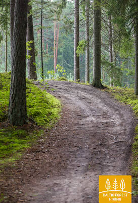
Metsa matkarada suundub läbi lummavate männimetsade ja märgalade, üle ja ümber küngaste ja mägede. Eriti ilus vaade Gauja jõele avaneb Sietiņiezise paljandilt ning tasub võtta aega ja rännata siinsel Sietiņiezise matkarajal. Edasi viib rada läbi külamaastike ja metsade Valmierasse. Pärast Valmiera ümbersõitu kulgeb metsa matkarada kõnniteedel. Viimane lõik, mis algab vana Dzelzītise raudteesilla juurest ja viib Cēsise tänavani, kulgeb Gauja jõe äärsel metsarajal.

Sietiņiezises (parkla kõrval, info olemas) on lastega peredele loodud spetsiaalne ringikujuline õpperada.
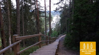
 10. päev. Strenči ‒ Spicu sild.
Läbi ilusate Vidzeme metsade
Selles lõigus langeb metsa matkarada kokku Gauja matkarajaga, mis kulgeb otse Gauja jõe kallastel. Kahes kohas ületab metsa matkarada A3 maantee (enne Seda linna keeramist ja enne Kaučit – ole ettevaatlik!) ning jätkub väikestel metsateedel liiva-kruusakarjäärini, keerates seejärel Oliņasse suunduvale kruusateele. 3,5 km pärast keerab rada taas paremale ja suundub väikeseid ja üksildasi metsateid pidi Spicu sillani, kus Zemā saare ehk Madala saare juures avanevad Põhja-Gauja (Ziemeļgauja) maastikukaitseala kõige ilusamad vaated. Päevateekonna lõpus, kus maantee P24 kulgeb Spicu silda pidi üle Gauja jõe, on telkimis- ja piknikuplats.
Strenčis, Gauja jõe paremkaldal mõlemal pool silda, on rajatud loodusrada kahe aasaga – 5 km ja 7 km pikk. Raja ääres on puhkekohad, infosildid ja tualett. Osale teest pääseb jalutuskäruga.
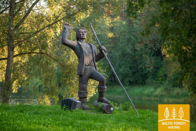
 20. päev. Kolodavitsa‒Värska.
Setomaa ajalooline pärand ja elav kultuur
Metsa matkarada viib teelise läbi Setomaa suurte metsade, piki rabasid ja nõmmesid, mis augustis ja septembris on kanarbikuõitest imeliselt lillaks värvunud. See on hõredasti asustatud piirkond ning matkajal on võimalik loodusega tõeliselt ühenduses olla. Õrsava järve ääres jäävad teele mitmed sillakesed. Rada teeb tiiru ümber Õrsava järve ja kulgeb Värska aleviku keskusesse. Võta aega ning tutvu seto kommete ja kohalike roogadega.
Sektsioonis on peresõbralikud atraktsioonid, sealhulgas Verska setu maamuuseum, lastele mõeldud programmid loomadega ja mänguväljakud. Rēgi majas on loomisel 3D programm lastega peredele.
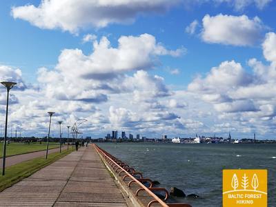
50. päev. Püünsi‒Tallinn.
Tallinna vanalinna pilgupüüdjad
Metsa matkarada kulgeb piki Tallinna lahe rannikut ning alates Püünsist avanevad kaunid vaated Tallinna tornidele, pilvelõhkujatele ja sadamale. Enne Piritat pöörab rada männimetsa, seejärel aga kahekilomeetrilisele Pirita liivarannale. Pärast Piritat kulgeb rada kuni Tallinna sadamani kenal rannaäärsel promenaadil, kust avaneb vaade linna kultuurilistele ja ajaloolistele vaatamisväärsustele ning merele ja sadamale. Metsa matkaraja lõpp-punkt asubki vanalinna kõrval asuvas Tallinna sadamas. Võta päev või paar, et põhjalikumalt tutvuda Tallinna arvukate vaatamisväärsustega.
Tallinnas on palju lapsesõbralikke ja huvitavaid muuseume nagu Eesti Vabaõhumuuseum ja Lennusadam. Linnas on hästi arenenud kõnniteede võrgustik, mis teeb lapsevanematele lapsekäruga lihtsaks.
63. päev. Vaišvydava – Kaunas.
Läbi Kaunase parkide
Kaunase veehoidla regionaalpargi külastuskeskusest viib Metsa matkarada läbi Rokų metsa ja piki Miškininkų, Kelmyno, Muraškinėse, Žarstose, Garšvėse ja Rokelių tänavaid Kaunase kesklinna suunas. Veidi aega tiirutab rada Kaunase eeslinnades, ületab Marijampolė maantee (nr 139) suundub Balčkalnio tänava kaudu Panemunė linnaosasse. Kaunase Tehnikaülikooli staadioni juurest laskub rada Vaidoto tänavale, jätkab teekonda Baterijose maantee ääres oleval kõnniteel, kuni keerab vasakule. Umbes kolmandik Kaunase linna pindalast on kaetud parkide ja teiste looduslike aladega. Metsa matkarada kulgeb läbi linna kõige rohelisemate alade. Umbes 2,5 km pikkuselt lookleb rada Panemunė männikus, kus on arvukalt teeradu, puhkealasid ja isegi supelrand. Nüüd ületab Metsa matkarada Kolme Neitsi silla kaudu Nemunase jõe, kulgeb läbi Gričiupise linnaosa, mööda Kaunase loomaaiast, läbib uhke Ąžuolynase tammiku ning jõuab Leedu Spordiülikooli taha asuvasse Vytauto parki. Pargist laskub rada mööda treppi Vabaduse puiesteele (Laisvės Alėja) ning suundub kindlalt Kaunase kesklinna.
TÄHTIS. Kaunase linna läbivatel lõikudel märgistus puudub.
Panemunese mets (Panemunės šilas), mis on ümbritsetud Nemunase jõe laia käänakuga, on Leedus vanuselt kolmas park, mis on tekkinud looduslikus metsas. Park on läbi põimunud asfaldi- ja looduslike radade ja radade võrgustikuga. Nii nagu Oak Park, sobib see erineva pikkusega jalutuskäikudeks.
78. päev. Biržuvėnai – Telšiai.
Teel Telšiaisse, Žemaitija piirkonna pealinna
Päeva esimesed 3 km mööduvad Biržuvėnai metsas. Kilomeeter enne Rudupiai külla jõudmist kulgeb Metsa matkarada Luokė–Viešvėnai teel (nr 4605), kuni pöörab paremale, loode suunas. Järgmised 11 km kulgevad põllumajandusmaastikul. Pärast Rainiai küla ühtib Metsa matkarada Telšiai suunas viiva kergliiklusteega. Linna jõudes keerab rada Kaunase tänavale ning jõuab Mastise järve kaldale. Seejärel lookleb matkarada läbi pargi, kus Zaksase mäelt avanevad kaunid vaated Mastise järve panoraamile. Lõpuks teeb Metsa matkarada looke ümber Mastise järve väikse lahesopi ja jõuab päevateekonna lõpp-punkti.
Telšu järve põhjaosa ümbritseb rannapromenaad, mis sobib erineva pikkusega jalutuskäikudeks ja lühikesteks matkadeks. Promenaad sobib ka käruga lapsevanematele.
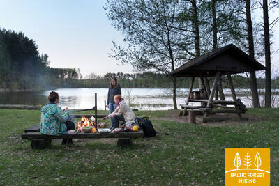
91. päev. Aizpute – Snēpele.
Parun von Manteuffeli jälgedel
Mööda Atmoda ja Jelgava tänavaid suundub Metsa matkarada Aizpute linnast välja, keerab pärast Laža veehoidlat paremale ja jõuab suure kaarega Kazdanga mõisaparki. Nüüd muutub matkarada väikseks teerajaks, mis kulgeb piki Dzirnavu järve kallast läbi mõisapargi, ümber mõisahoonete ja Zēnu tiigi, kuni jõuab Kazdanga–Cildi teele (V1200), kust keerab 0,7 km pärast Snēpele–Kazdanga teele (V1296). Kuni Zemturi puhkemajani tõuseb Metsa matkarada järk-järgult mööda Bandava mägesid kõrgemale, avades kauneid vaateid ümbritsevale Rietumkursa kõrgustikule. Küngaste kõrgused ulatuvad maksimaalselt 81 meetrini ü.m.p. Zemturi puhkemajast edasi suundudes kulgeb Metsa matkarada 12 km pikkuselt läbi hõredalt asustatud metsamassiivi, kuni jõuab viimaseks kolmeks kilomeetriks tagasi avamaastikule, kus valdavad põllud ja väiketalud. Teekonna lõpp-punkt asub Snēpele külas.
Läti suurimas pargis Kazdanga pargis on rajatud 9 km pikkune radade võrgustik. Rajad on tähistatud, saadaval on GPX-failid ja selleks on määratud puhkealad. Mõned sektsioonid sobivad neile, kellel on jalutuskärud. Lisateabe saamiseks külastage: https://www.kurzemesregions.lv/projekti/turisms/unigreen/dabas-takas/kazdangas-parka-dabas-taka/
95. päev. Sabile - Kandava.
Üks Kuramaa kaunimaid loodusparke
Metsa matkarada suundub Abava vasakkaldal kulgeva Kr. Barona tänava kaudu Sabilest välja. Väike rajake viib üle Abava ürgoru niitude ja läbi metsatukkade, kuni jõuab Rootsi Kaabu nimelise mäeni. Seejärel viib rada mööda väikest külateed Plosti–Pūcese teele (V1471), ületab Amula jõe ja naaseb Kalnmuižas Abava orgu, kust jõuab 6 km pärast Aizdzire mõisaparki. Nüüd keerab rada põhja suunas ja ületab kilomeetri pärast Abava jõe. Siin on Abava ürgorg oma täies ilus. Oru sügavus on ligi 40 meetrit. Pärast Kalamehe silda tõuseb Metsa matkarada Abava ürgoru põhjanõlvale, kus on arvukalt viinapuuistandusi. Läbi metsa loogeldes ristub matkarada Kandava–Renda teega (P130) ning saabub lõpuks piki Sabile tänavat Kandava linna. Teekond armsas väikelinnas kulgeb mööda Lauku, Ozola, Zīļu, Sabile ja Pilsi tänavaid, kuni jõuab sihtpunkti, Kandava ordulinnuse varemeteni. Kogu selle päeva teekond kulgeb Abava jõe ürgoru maastikukaitsealal.
Sektsioonis on lastele erinevaid atraktsioone ja tegevusi, nagu rootsi müts, kelgud, kärud jpm.
98. päev. Tukums - Jāņukrogs.
Läbi piirkonna parimate seenemetsade
Piki Melnezera tänavat lahkub Metsa matkarada Tukumsi linnast. Kuni Milzkalneni lookleb rada ilusas metsas, välja arvatud väike lõik Jaunūdru teel. Rada läheb mööda Raudase küngastiku järsupoolseid nõlvu muudkui üles ja alla. Üks siinseid kõrgemaid tippe on Milzkalnsi mägi, mis ulatub 113 meetrit üle merepinna. Pärast Tukumsi–Milzkalne–Smārde teed (V1446) viib Metsa matkarada läbi Šlokenbeka mõisa territooriumi, ületab Slocene jõe, teeb looke ümber Bērzāji küla ning suundub seejärel Slocene jõe vasakkallast pidi läbi ilusate metsade Tukumsi–Milzkalne–Smārde tee ääres asuva Kārniņi kalmistu suunas. Valguma järv, mille ümbruses on mitmeid majutuskohti, on siit umbes 2,5 km kaugusel. Veidi pärast Bērzāji küla on matkaja jõudnud Ķemeri rahvuspargi territooriumile.
Huvitav koht lastele on Slokenbekase mõis, kus on muuseum, kohvik ja võimalus lühendada marsruuti rongiga tagasi Tukumsisse. Teise võimalusena võite jätkata marsruudi lõppu, külastada Tagurpidi maja või jalutada Smārde jaama ja nautida rongireisi. Smārdes on ka atraktsioonid, mida saab seikluse põnevamaks muutmiseks kaasata.
99. päev. Jāņukrogs – Bigauņciems.
Läbi Ķemeri rahvuspargi
Veidi aega kulgeb Metsa matkarada kultuurmaastikul, jõudes seejärel ilusasse okasmetsa, mööda Čaukciemsi asulast kuni keerab Antiņciemsi–Smārde teele, et siirduda Rohelise Luite (Zaļā kāpa) poole. Maastik on tasane, sest rada on jõudnud Piejūrase madalikul asuvale Engre lammile. Roheliselt Luitelt avanevad ulatuslikud vaated Rohesoole (Zaļais purvs) ja Nõiasoole (Raganu purvs). Väike metsatee viib mööda luitejalamit, kahes kohas viivad purded üle soolappide. Ķemerisse jõudes kulgeb Metsa matkarada piki Partizāna, Robeža, A. Upīša, Katedrāle ja E. Dārziņa tänavaid, mööda rahvuspargi külastuskeskusest ja Vēršupīte jõest, kuhu suubuvad sulfaadirikkad allikad. Rada ületab Tūristi tänava ning viib mööda Dūņu teed edasi Sloka järve poole. Seejärel jõuab rada Vēršupīte lodumetsa, mis on üks omalaadsemaid metsatüüpe kogu Kuramaale jääval Metsa matkaraja osal. Melnezersis keerab matkarada Ķemeri vanale maanteele ning saabub 2 km pärast Bigauņciemsi. Õige pea ületab Metsa matkarada Talsi maantee ning jõuab Liivi lahe rannikule, kus kohtub Ranniku matkarajaga. Kogu päeva teekond möödub Ķemeri rahvuspargis.
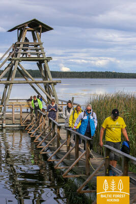
Ķemeri kuurordipark, mis ümbritseb Vēršupīte jõge koos arvukate jalgsillade ja Metsamaja lähedal asuva Musta lepa soo laudteega (0,6 km pikk), on peresõbralik ja jalutuskärudele ligipääsetav. Tagurpidi maja on samuti huvitav vaatamisväärsus.