


Baltic Forest Hiking - Cultural experience


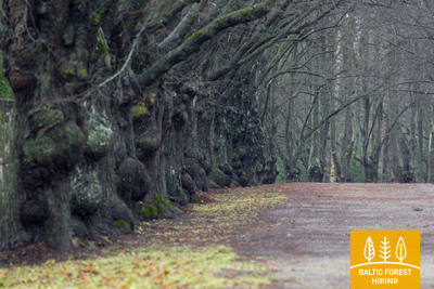
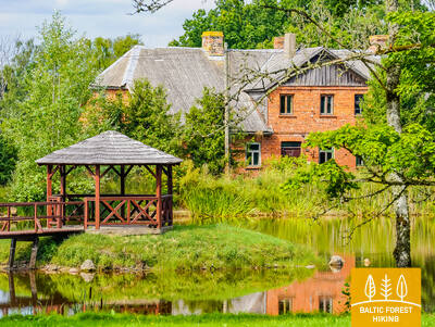
 1. posms. Vecrīga - Baltezers.
Cauri Rīgai – UNESCO Pasaules mantojuma vietai
Latvijā Mežtakas sākums atrodams Vecrīgas sirdī – Rātslaukumā. Maršruts ved pa Kaļķu ielu, garām Brīvības piemineklim, cauri Vērmanes dārzam un pa vēsturisko Tērbatas ielu. Tālāk tas izmet loku pa gājēju tiltu pāri Zemitānu dzelzceļa stacijai un turpinās pa Biķernieku un Šmerļa mežiem. Mežtaka vijas cauri Juglai, gar Latvijas Etnogrāfisko brīvdabas muzeju un pa gājēju un velosipēdistu celiņiem aizved līdz Baltezeram.
Rīgas vēsturiskais centrs ir UNESCO pasaules mantojuma piemineklis ar bagātīgu kultūras pieminekļu klāstu. Rīga ir vieta, kur ir vislielākā muzeju, izstāžu un dažādu ikgadējo pasākumu norises vieta. Rīgā ir pieejams visplašākais ēdināšanas uzņēmumu un restorānu klāsts, t.sk. latviskie ēdieni, suvenīri un pasākumi, kas saistīti ar valsts u.c. tradīcijām.
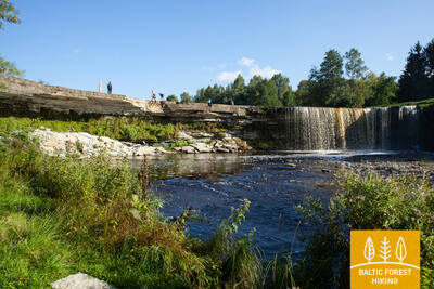
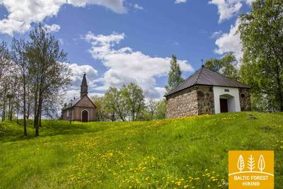
 4. posms. Rāmkalni - Sigulda.
Skaistākie Gaujas senlejas skati pie Siguldas
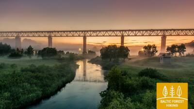
Aiz „Rāmkalniem” Mežtaka uzvijas augstajā Gaujas senlejas stāvkrastā un pa tā augšdaļu izved cauri Gaujas ciemam, līdz atkal nonāk lejā. Tālāk tā šķērso Lorupi un aizvijas gar Gaujas līkumiem līdz vienam no iespaidīgākajiem Gaujas atsegumiem – Velnalas klintīm, tad uzved Ķeizarskatā un apmet loku līdz Ķeizarkrēslam, Kaķīškalna „Mežakaķim” un Siguldas bobsleja un kamaniņu trasei, līdz sasniedz Siguldas centru.
Sigulda ir viens no populārākajiem Latvijas tūrisma galamērķiem. Ievērojama ar trīs viduslaiku pils drupām, muižām, Gūtmaņalu, Turaidas muzejrezervātu un ikgadējiem kultūras pasākumiem, t.sk. Siguldas Opermūzikas svētkiem u.c. pasākumiem un objektiem.
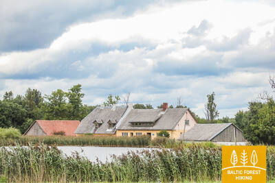
5. posms. Sigulda - Līgatne.
Gaujas Nacionālā parka sirdī
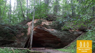
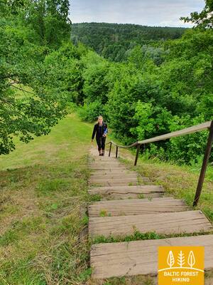
Izmetusi loku cauri Siguldai, Mežtaka gar Vējupītes gravas kreisā krasta augšdaļu nonāk līdz Paradīzes kalnam, no kura pa stāvām kāpnēm ved lejup Gaujas senlejā un Vējupītes gravā. Lielāko daļu no tālākā maršruta Mežtaka virzās pa mazām, vientuļām meža takām un cauri nelielām pļavām (jūnijā zied sveķenes), šķērsojot daudzu mazo upīšu gravas, kuru krastos slejas smilšakmens atsegumi. Posma pēdējie seši kilometri virzās pa nelielu ceļu gar Līgatnes dabas takām. Pirms Līgatnes Mežtaka paceļas augšup pa Gaujas senlejas nogāzi, bet Līgatnē atkal nolaižas Līgatnes upītes dziļajā gravā, kuras krastos izvietojies bijušās Līgatnes papīrfabrikas ciemats.
Līgatnē ir plašs ēdināšanas pakalpojumu piedāvājums, kur piedāvā ēdienus no vietējiem produktiem, latviskos ēdienus, kā arī Līgatnē ražotus dzērienus. Restorānam "Pavāru māja" ir ir piešķirta "Michelin" zaļā zvaigzne. Suvenīru tirgošanās vietās var iegādāties vietējos suvenīrus. Līgantes papīrfabrikas ciemats ir industriālā mantojuma piemineklis ar bijušām ražošanas un noliktavu ēkām, dzīvojamām ēkām (barakām), alām, kur glabāja dārzeņus, Līgatnes pārceltuvi. Netālu atrodas slepenais Līgatnes bunkurs.
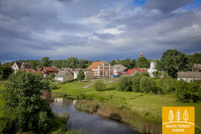
 9. posms. Valmiera - Strenči.
Gar Abula krastiem uz Strenčiem – plostnieku galvaspilsētu
Mežtaka izvijas cauri Valmieras vēsturiskajam centram un Atpūtas parkam, kurā ir vairāki pilsētas apkaimes kājāmiešanas un nūjošanas maršruti, šķērso Vanšu tiltu, ved gar Pauku priedēm un Baiļu kalnu. Pa Abula taku, kas izlokās pa stāvajiem un „mežonīgajiem” upes krastiem, tā aizlīkumo līdz Brenguļu alus darītavai un tālāk, aiz Pūpoliem, jau ved pa mazapdzīvotiem, plašiem mežu masīviem. Šī posma pirmās puses raksturīga iezīme ir mazie vasarnīcu ciemi – Enerģētiķis, Saulītes, Sprīdītis, Gaujmaļi, Pūpoli un Gaujaslāči, kas sāka veidoties padomju laikā kā Valmieras un apkaimes rūpniecības uzņēmumu vasarnīcu rajoni. Pie Ūdriņām Mežtaka izved cauri vecupju labirintam un pagriežas uz ziemeļiem, šķērsojot Gaujas tiltu, pie kura ir atpūtas un laivotāju pieturvieta. No šejienes līdz Strenču centram ir ~ 1,5 km. Daļa no posma atrodas Ziemeļgaujas aizsargājamo ainavu apvidū.
Valmieras vēsturiskais centrs ar Livonijas ordeņa pils drupām, Sv. Sīmaņa baznīcu, pilsētas mūru fragmentiem u.c. kultūras pieminekļiem. Valmiermuižas alus darītavā un restorānos var baudīt gardēžu tūres un apmeklēt ražotni. Brenguļos var nobaudīt Brenguļu alus darītavas produkciju. Strenči ir Latvijas plostnieku galvaspilsēta, kur plostnieku tradīcijas tiek saglabātas arī mūsdienās.
19. posms. Vanavastselīna (Vana-Vastseliina) – Kolodavitsa.
Gar straujākās Igaunijas upes Piuzas (Piusa) krastiem
Mežtakas posma pirmā trešdaļa izlokās pa skaistās Piuzas upes ielejas takām, bet pie Hermas (Härma) ciema pagriežas uz Obinitsu (Obinitsa), kas ir nozīmīgs Setu zemes jeb Setomā (Setomaa) kultūras centrs. Šeit ir vērts izbaudīt vietējās Setu tradīcijas. Aiz Obinitsas Mežtaka atkal vijas cauri skaistiem priežu mežiem ar virsājiem, vēlreiz nolaižas dziļajā Piuzas ielejā un pie Piuzas alām pagriežas austrumu virzienā. Tālāk tā seko Piuzas ielejas kreisā krasta nogāzei, līdz sasniedz nākamo orientieri – autoceļu un dzelzceļa līnijas pirms Koidulas dzelzceļa stacijas.
Mežtakas posms, kas reprezentē setu kultūrtelpu ar materiālā un nemateriālā mantojuma objektiem - muzejiem, sakrālām celtnēm un iespēju baudīt setu tradicionālos ēdienus, klausīties dziesmas, skatīties dejas u.c. Posma sākumā atrodas Vanavastselīnas bīskapa pilsdrupas ar muzeju, no kurām tālāk puse no posma maršruta ved pa Piuzas ieleju.
20. posms. Kolodavitsa – Verska (Värska).
Vēstures mantojums un dzīvās tradīcijas Setu zemē
Mežtaka ved cauri plašajiem Setu zemes jeb Setomā (Setomaa) mežiem, gar purvu malām un cauri virsājiem, kas septembrī iegūst pasakaini violetus krāsu toņus. Šis ir mazapdzīvots apvidus, kur gājējs sajutīs ciešu saikni ar savvaļas dabu. Pie Ersavas (Õrsava) ezera Mežtaka šķērso gājēju tiltiņus, apmetot loku ezeram, līdz nonāk Verskas centrā. Arī šajā posmā ir iespēja izbaudīt Setu zemes tradīcijas, ēdienu un dzērienus.
Verskā var baudīt Setu zemes tradīcijas - kulināro un nemateriālo mantojumu, kā arī izzināt minerālūdens kūrorta vēsturi.
Verskā t.s. Ziemeļu nometne (North camp) ir īpašs militārā mantojuma objekts Igaunijā, kas līdzīgā formā nekur citur nav saglabājies. Ir pieejami gidi, kas izvadā interesentus pa minētajām vietām.
21. posms. Verska (Värska) – Ristipalo.
Verska – vēsturiskais kūrorts
Pametusi Versku, Mežtaka pagriežas uz ziemeļrietumiem un īsu brīdi aizlokās netālu no Pleskavas ezera (Pihkva järv) Verskas līča. Izmetusi loku cauri lielākam mežu masīvam, tā iznāk pie Laosinas (Laossina) ciema, kur var iepazīt Setu reliģiskās tradīcijas. Mežtaka šajā posmā iet pa Peipusa (Peipsi) zemieni, tādēļ apkaime ir līdzena, un zemi šeit izmanto galvenokārt lauksaimniecībā. Šķērsojusi Vehandu (Võhandu) upi pie Vēpsu (Võõpsu) ciema, Mežtaka pagriežas uz Repinas (Räpina) pusi.
Verska ir populārs Dienvidaustrumu Igaunijas kūrorts, tādēļ šeit ir vērts uzturēties vismaz vienu papildus dienu un iepazīt apkaimes vēstures pieminekļus, sākot ar Ziemeļu nometni, Rēgi māju un Verskas setu māju un turpinot ar Verskas sanatoriju, apkaimes mežiem, izziņas takām un kapelām Mežtakas malās.
25. posms. Kavastu – Varnja.
Ceļā uz Varnjas vecticībnieku ciemu
Mežtaka jau trešo dienu met lielu loku apkārt Emajē-Sūrso (Emajõe-Suursoo) mitrājam (ietilpst dabas liegumā Peipsivēre (Peipsiveere)). Iešanai interesantākā ir šī posma daļa starp Vanausaija (Vanaussaia) un Varnju, kur Mežtaka iet pa maziem lauku ceļiem. Pirms Varnjas tā sasniedz Peipusa ezera (Peipsi järv) krastu, kur beidzot var apjaust ezera lielumu. Tālāk no Varnjas līdz Remniku seko nedēļu ilgs gājiens gar Peipusa piekrasti un tā tuvāko apkārtni, kura laikā gājējs iepazīst Austrumigaunijas tradicionālo kultūru – sīpolu audzēšanu un zvejniecību, kulināro mantojumu, amatniecību un vecticībnieku reliģiskās tradīcijas.
Viena no retajām vietām Eiropā, kur upes krastus savieno ar roku darbināma pārceltuve.
26. posms. Varnja – Alatskivi.
Ciemos pie Peipusa sīpolu audzētājiem
Ainavisks un tradīcijām bagāts Mežtakas posms, kura simbols ir sīpoli. Tie šajā reģionā nonāca līdz ar vecticībniekiem 17. gadsimtā. Par šejienes vizītkarti ir kļuvušas kundzes un kungi, kas ceļmalās pārdod pašdarinātas pašu audzēto sīpolu virtenes. 24 kilometrus garajā Varnjas (Varnja) – Kallastes (Kallaste) posmā Peipusa (Peipsi järv) ciemus apvieno “Sīpolu ceļš”. Ceļotājus priecē dažādās krāsās izkrāsotas koka dzīvojamās ēkas, nelieli zivju veikaliņi un restorāns, kurā var nobaudīt no patvāra ielietu tēju, ievērojot vecticībnieku tējas dzeršanas tradīcijas. Visa gada garumā var nobaudīt Peipusa repšus (igauniski – rääbis).
Interesants Peipusa piekrastes Mežtakas posms, kas īpaši vizuāli pievilcīgs kļūst rudenī, kad gar vecticībnieku ciemu ielām vietējie iedzīvotāji pārdod sīpolu virtenes un citus pašu audzētos lauku labumus. Iespējams apskatīt saimniecību, kur audzē sīpolus, baudīt tēju no patvāra, apmeklēt muzejus un ekspozīcijas, kas rāda vietējās tradīcijas. Posma noslēgumā atrodas Alatsikivi pils - dažādu kultūras pasākumu norises vieta.
27. posms. Alatskivi – Rannameiza (Rannamõisa).
Kūpinātas zivis un sīpolu pīrāgs – Peipusa kulinārais mantojums
Alatskivi ir lieliska vieta, kur nobaudīt Peipusa tradicionālos ēdienus, arī slaveno sīpolu pīrāgu. Aiz Alatskivi Mežtaka stiepjas pa reljefa pacēlumu, no kura paveras skaisti skati uz Peipusu (Peipsi järv), bet pie Kallastes (Kallaste) nolaižas līdz ezera krastam. Kallastē ir vērts uzmeklēt vietējo zivju restorānu un veikaliņu un nobaudīt kūpinātus Peipusa repšus (igauniski – rääbis) un zandartus. Mežtakas posma pēdējā trešdaļa iet gar ceļa malu, no kurienes atkal vērojami skaisti skati uz ezeru.
Vērts izstaigāt Kallastes ieliņas un Peipusa krastu iepretim Kallastei, pasēdēt kādā no piekrastes kafeinīcām un iebaudīt Peipusa sīgu, vai citu kūpinātu vai citādi sagatavotu zivi. Rudenī, tāpat kā citos Peipusa ciemos, te var iegādāties vietējo iedzīvotāju pašaudzētās sīpolu virtenes u.c. lauku labumus. Piemērota vieta fotografēšanai, filmēšanai, īpaši pie Kalastes smilšakmens atsegumiem. Alatsikivi pils ar parku - iecienīts galamērķis.
28. posms. Rannameiza (Rannamõisa) – Mustvē (Mustvee).
Cauri krāsainajiem Peipusa ciemiem uz Mustvē
Sīpoli, zivis, kilometriem gari ciemi, kur ēkas izvietojušās gar galveno ielu, izrotāti vecticībnieku dievnami, mazas ostiņas ar zvejnieku laivām un koka dzīvojamie namiņi – katrs savā krāsā! Kafejnīcas, veikaliņi un skats uz Peipusu (Peipsi järv), kas atgādina jūru, nevis ezeru. Tāda ir šī Mežtakas posma vizītkarte. 8 kilometru garumā no Kasepē (Kasepää) līdz Mustvē Mežtaka iet cauri mazajiem piekrastes ciemiem, piedāvājot patīkamu pārmaiņu tiem, kas jau gājuši ilgāku laiku pirms tam.
Pilsētvides ziņā - interesants Mežtakas posms, kas izved cauri mazajiem Peipusa piekrastes ciemiem ar savdabīgu mazstāvu arhitektūru, daudzām sakrālām celtnēm. Šejienes tradīcijas un vēsturi var iepazīt muzejos un izstādēs.
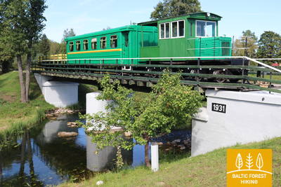
29. posms. Mustvē (Mustvee) – Avinurme.
Pa bijušo Sondas–Mustvē šaursliežu dzelzceļa līniju
Pametusi Mustvē promenādi un pludmali, Mežtaka izlīkumo cauri pilsētai un tālāk 16 km garumā ved pa bijušo Sondas–Mustvē šaursliežu dzelzceļa līniju, kuras vietā ir izveidots grants seguma ceļš – taisns kā bulta, kas savieno Mustvē ar Avinurmi. Informatīvi stendi gar bijušā dzelzceļa malām vēsta par kādreizējām apdzīvotajām vietām, kur tagad šalko mežs vai izcirtumi, kuros atkal ieaudzēs mežu.
Vienīgā vieta Mežtakā (E11), kur tik garā posmā (16 km garumā) maršruts iet pa bijušo šaursliežu dzelzceļa līniju. Avinurmē iespējams apskatīt arī rekonstruēto vilcienu. Avinurmē vērts apmeklēt Avinurmes dzīvesveida centru, kur var piedalīties meistarklasēs un iegādāties vietējo amatnieku suvenīrus, kā arī iemalkot garšīgu kafiju ar vietējām kūkām.
33. posms. Remniku – Kuremē (Kuremäe).
Cauri Igaunijas jaunākajam - Alutaguses nacionālajam parkam
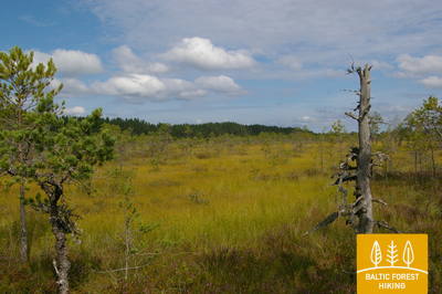
Mežtaka šajā un nākamajā dienā izvijas cauri jaunākajam Igaunijas nacionālajam parkam – Alutaguses Nacionālajam parkam (precīzāk – atsevišķām un plašākā apkārtnē izveidotām šī parka daļām), kas dibināts 2018. gadā. Parka svarīgākais mērķis ir Igaunijas lielāko skujkoku mežu un purvu apgabalu aizsardzība. Šis ir arī viens no mazapdzīvotākajiem ziemeļaustrumu Igaunijas apvidiem.
Kuremäe - nozīmīgs sakrālā tūrisma un svētceļojumu galamērķis.
35. posms. Vasavere - Toila.
Ceļā uz klinšaino Ziemeļigaunijas krastu pie Toilas
Aiz Vasaveres Mežtaka vēl īsu brīdi izlokās pa Kurtnas aizsargājamo ainavu apvidu, apjož kūdrā izstrādātu purvu masīvu, šķērso Oru pilsētu un, apmetusi loku apkārt Vokas upes ielejai, nonāk pie Baltijas jūras, kur pagriežas uz rietumiem. Šeit, Somu līča krastā, paceļas t. s. Ziemeļigaunijas glints – stāva, klinšaina un ar mežu apaugusi kāple, kas ar īsākiem vai garākiem pārtraukumiem stiepjas līdz Tallinai un tālāk līdz Rietumigaunijas salām. Mežtaka iet pa glinta augšpusi, nolaizdamās upju ielejās. Toilas-Oru parkā tā šķērso dziļo un plašo Pihajegi (Pühajõgi) ieleju un nonāk Toilā – populārā piekrastes kūrortā.
Ziemeļigaunijas vēsturei nozīmīgs ir Oru parks ar kādreiz iespaidīgo muižu, dārzu, terasēm un ainavām uz Pehahegi upi un Somu līci. Pili nopostīja Otrā pasaules kara laikā, bet parks ar dārziem mūsdienās tiek kopts.
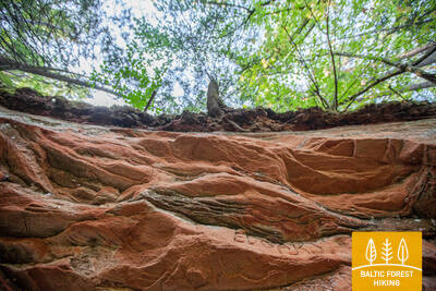
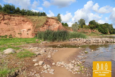
37. posms. Saka - Aseri.
Miljoniem gadu veci pārakmeņojumi jūras krastā
Pie Sakas muižas Mežtaka pa stāvām kāpnēm nolaižas līdz jūras krastam, kur tālāk nepilnu 6 km garumā stiepjas pa pludmali. Pie Moldovas un Jabaras ciemiem Mežtaka atkal paceļas Ziemeļigaunijas glintā (plašas ainavas no Viru pacēluma), caur Purtses ciemu apmet loku Purtses upei un tālāk pa glinta apakšpusi gar šauro jūras krastu ved uz Aseri. Īsi pirms pilsētiņas tā atkal uzved augšup pa glinta nogāzi. Jūras krastā, lejpus Ziemeļigaunijas glintam, var redzēt dzīvnieku fosilijas, kuru vecums ir vairāki simti miljonu gadu.
Mežtakas posms, kurā ir liela dažādu tipu un vēsturisko periodu liecības, sākot ar dzelzs laikmeta senkapiem un svētvietām, turpinot viduslaiku cietokšņiem, māla ieguves karjeriem un spirta kontrabandas tūrisma centru.
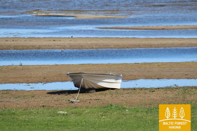
39. posms. Mahu - Kunda.
Kundas industriālo mantojumu pieredzot
Pie Mahu Mežtaka iet pa maziem piekrastes ceļiem tuvu jūrai. Ir vērts izmest 2 km garu līkumu (turp un atpakaļ) līdz Ehalkivi dižakmenim. No Simunamē (Simunamäe) 3 kilometru garumā Mežtaka ved pa ceļu Ziemeļigaunijas glinta piekājē, ko klāj primārais mežs. Jūras krasts šeit atrodas aptuveni kilometra attālumā. Lontovas muižas apkaimē izvietotas informatīvas plāksnes par Kundas vēsturi. Savukārt, Kundas upes krastos un pilsētā ieteicams iepazīt objektus, kas saistīti ar pilsētas cementa ražotnes vēsturisko attīstību.
Mežtakas posma finišā atrodas Kunda - pilsēta ar senu industriālo vēsturi, kas saistīta ar cementa ieguvi un Baltijas valstīs pirmo hidroelektrostaciju.
46. posms. Tsitre – Kabernēme (Kaberneeme).
Smilšainie liedagi un salas Kolgas līcī
Pie Tsitres ciema jau vikingu laikā atradusies osta. Mežtakas šī posma pirmie 4 km atrodas Lahemā (Lahemaa) Nacionālā parka teritorijā. Starp Mūksi (Muuksi) un Sorinnas (Soorinna) ciemiem ceļš šķērso ovālu platoveida pauguru – Ziemeļigaunijas glinta pacēlumu, ko klāj ainaviski kadiķu lauki. Pie Pihja (Põhja) ciema taka apmet loku piekrastes mitrājam un aiz Salmistu laivu ostas iznāk jūras krastā. No šejienes ziemeļaustrumos labi redzama 1,3 km attālā Pedasāres (Pedassaar) sala, bet ziemeļaustrumos – mazā Umblu un nedaudz lielākā Rohusi sala. Pie Valklas pludmales gājējus priecē jauks pludmales restorāns. Hāpses (Haapse) pludmalē ir peldvieta, kur jūra strauji kļūst dziļa.
Mežtakas posms, kur var iepazīt vietējās tradīcijas, piedalīties radošajās darbnīcās u.c.: Lahemā kultūras mantojuma nams, kalēju darbnīca, Tomani lauku sēta - muzejs, kā arī bagātīgs vēstures objektu klāsts - senkapi, svētozols un militārais mantojums.
47. posms. Kabernēme (Kaberneeme) – Jēlehtme (Jõelähtme).
Gar Jegalas (Jägala) upes krastiem
No Kabernēmes maršruts ved pa mežu, kur vērojami akmeņu krāvumi, kas radušies pēdējā ledus laikmetā. Tālāk Mežtaka uzvijas 20 m augstumā un ved gar bijušo Ancilus ezera krastu. Pirms ierašanās Kalevi-Līvas (Kalevi-Liiva) holokausta memoriālā, taka šķērso Kaberlas–Kabernēmes ceļu un ved pa Kaberlas strauta ieleju. Tālāk Mežtaka turpinās līdz Linnamē (Linnamäe) HES un trošu tiltam, gar seno Linnamē pilskalnu maršruts ved gar Jegalas upes labo krastu līdz Jegalas ūdenskritumam. 500 metrus uz augšu no ūdenskrituma atrodas Suka tilts, kuru šķērsojot, nonāk upes pretējā krastā. Tālāk Mežtaka izved cauri Kogi ciemam un nonāk Jēlehtmē.
Mežtakas posms ar daudzveidīgu kultūras un industriālo mantojumu: spēcīgākā Igaunijas hidroelektrostacija, Rebalas kultūrvēsturiskā teritorija ar apmeklētāju centru un senkapiem, sakrālas celtnes, hololaustam veltītais piemineklis.
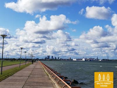
50. posms. Pūnsi (Püünsi) – Tallina.
Skaistākie skati uz Tallinas vecpilsētu
Mežtaka iet gar Tallinas līča krastu, kur jau no Pūnsi paveras skaisti skati uz vecpilsētas torņiem, ostu un pilsētas augstceltnēm. Pirms Piritas (Pirita) Mežtaka izlokās pa skaistu priežu mežu un tālāk ved gar jūras krastu pa 2 km garu smilšainu pludmali. Aiz Piritas līdz pat Tallinas ostai Mežtaka aizved pa skaisto pilsētas krasta promenādi, no kuras redzami nozīmīgi pilsētas kultūras un vēstures objekti un baudāmi jūras un ostas skati. Mežtakas finišs atrodas Tallinas ostā, kurai blakus atrodas Tallinas vecpilsēta. Tās apskatei vēlams atlicināt vismaz vienu vai divas atsevišķas dienas.
Bagātīgs kultūras mantojums piekrastes ciemos, Piritā un Tallinā - muzeji, sakrālas celtnes, pieminekļi, pilis un piekrastes parki. Tallinas vēsturiskais centrs - UNESCO mantojuma objekts.
Tallina ir kultūras pasākumiem bagātākā pilsēta, kur var iepazīt Igaunijas kulināro mantojumu, tradīcijas u.c.
54. posms. Didžiasalis – Druskininkai – Žiogeliai.
Druskininkai – populārākais Dienvidlietuvas kūrorts
Starp Didžiasalis ciemu un Druskininkai kūrortpilsētu Mežtaka ved pa skujkoku mežu ar bagātīgām ogu un sēņu vietām. Pirms Druskininkai Mežtaka iznāk uz Nemuno ceļa, apmet loku Druskininkai Sniega arēnai un tālāk pa gājēju/velo celiņu aizved līdz Parko tiltam pāri Nemunas upei. Šķērsojusi tiltu, Mežtaka turpina gaitu pa Maironio gatvi. Tālāk tā izlīkumo pa Druskininkai vēsturiskā kūrorta mazajām ieliņām un parka celiņiem, šķērso Ratnyčia upīti un mežaparku Nemunas ielejas labajā krastā. Aiz Veisiejų ielas tā turpinās pa Neravų ielas gājēju ietvi un pēc aptuveni 1 km nogriežas pa kreisi uz Sodžiaus ielas, kas Neravai ciema beigās turpinās kā skaists meža ceļš. Šeit sākas Dzūkijas nacionālais parks. Mežtaka apmet loku Viečiūnai ciemam, atklājot skaistas ainavas un skatu uz Liškiava klosteri pretējā Nemunas krastā. Līdz pat Žiogeliai ciemam Mežtaka ved pa skaistu, vientuļu meža ceļu
Posms šķērso Druskininkus - populārāko Dienvidlietuvas kūrortpilsētu ar senām kūrortoloģiskām tradīcijām un daudziem kultūras pieminekļiem - sanatorijām, parkiem, avotiem, muzejiem u.c. Druskininki ir dažādu ikgadējo kultūras pasākumu norises vieta. Posma otrajā daļā pie Nemunas ir skaists skats uz Liškiavas klosteri.
57. posms. Nemunaitis – Alytus.
Pāri augstākajam gājēju tiltam uz Alītu
No Nemunaitis pa Vytauto ielu un Kaniūkai – Einorai – Nemunaitis ceļu (Nr. 1102) Mežtaka atpuveni 1,5 km ved ziemeļaustrumu virzienā, tad pagriežas pa kreisi uz ziemeļiem un pēc 3 km sasniedz Gečialaukis ciemu. Tālāk Mežtaka pagriežas pa labi uz austrumiem un pēc 3,3 km vēlreiz satiekas ar ceļu Nr. 1102. Vēl pēc 3,3 km Mežtaka sasniedz ceļu Nr. 128 un pa gājēju ietvi nolaižas Nemunas ielejā. No šejienes vairāk kā 3 km gara, skaista Nemunas ielejas taka cauri mežam aizved līdz gājēju tiltam pāri upei. Pēc krietna kāpiena Lietuvas augstākajā gājēju tiltā skatam paveras plašā un varenā Nemunas ainava. Aiz tilta Mežtaka virzās pa bijušā dzelzceļa dambi, izlīkumo pa Alytus kūrorta parka mazajiem celiņiem un pilsētas centrā pa S. Dariaus un S. Girėno ielām sasniedz Vecpilsētas (Senamiesčio) skvēru, kura dienvidu pusē atrodas Alītas tūrisma informācijas centrs.
Posma galā atrodas Alīta - populārs Dienvidlietuvas kūrorts ar liecībām - interesantiem apskates objektiem, kas stāsta par kūrorta attīstības vēsturi - parkiem, skvēriem, dārziem, skulptūrām, muzeju, vecā dzelzceļa vietu un augstāko gājēju - velosipēdu tiltu Lietuvā. Alīta - populāra dažādu ikgadējo kultūras pasākumu norises vieta.
58. posms. Alytus – Panemunis.
Pa Dzūkijas augstienes pakalniem
No Alītas Mežtaka izved pa Vilniaus ielu, šķērso Nemunu pa A. Juozapavičiaus tiltu, tad pa Jiezno ielu pagriežas pa kreisi uz ziemeļiem un tālāk pa Miškininkų ielu šķērso Normandijos–Nemuno ceļu (Nr. 1134). Pa taku cauri mežam pēc gandrīz 2 km Mežtaka iznāk uz neliela lauku ceļa un pa to 8 km turpinās ziemeļu virzienā. Šajā apkaimē ir plašas un atklātas Dzūkijas augstienes ainavas. Aiz Staniava ciema Mežtaka pa skaistu meža ceļu noved lejā pie Nemunas un pēc tam pa stāvu nogāzi uzved Punia pilskalnā, no kura paveras skats uz upi. Gar Puņas baznīcu pa Kauno, Šilo un Birštono ielām pēc nepilniem 4 km Mežtaka sasniedz lielāku meža masīvu. To šķērsojot, pēc 5 km Mežtaka iznāk pie Nemajūnu ciema. 3,5 km tālāk ir šī posma galamērķis.
Posmā apmeklējami daudzi kultūras un vēstures pieminekļi - sakrālās celtnes, pilskalns ar plašu skatu uz Nemunas ieleju, avots u.c. Maršruta otra daļa ietilpst Nemunas loku reģionālajā parkā.
59. posms. Panemunis – Birštonas.
Nemunas loki un etnogrāfiskas viensētas
Sekojot Nemunas loku līkumiem, Mežtaka izmet vairāk kā 20 km garu cilpu Nemunas loku reģionālajā parkā, izvijoties cauri atklātām ainavām un maziem ciemiem ar raksturīgām, dažādos toņos krāsotām koka ēkām. Lielāks meža masīvs ir tikai starp Sipoņu un Puzonys ciemiem, kuram cauri Mežtaka izved pa nelieliem meža ceļiem. Šķērsojusi Vilnius–Marijampolė ceļu (A16), Mežtaka nolaižas nākamajā Nemunas lokā (upes platums šaurākajā vietā – 1,2 km), kur atrodas iecienītais Birštonas kūrorts. Pa B. Sruogos ielas ietvi Mežtaka sasniedz Birštonas tūrisma informācijas centru.
Mežtakas posms ved cauri Nemunas lokiem, kur upes krastos izvietojušies nelieli, etnogrāfiska izskata ciemi ar interesantu koka arhitektūru. Maršruta noslēgumā atrodas Birštonas - viens no populārākajiem Dienvidlietuvas kūrortiem ar daudzām kultūras un vēstures liecībām: parkiem, skvēriem, dārziem, avotu ūdens ņemšanas vietām - buvetēm, paviljoniem, ārstniecības iestādēm, promenādēm. Kūrorta un Nemunas loku apskates nolūkā ir uzbūvēts Lietuvā augstākais skatu tornis.
64. posms. Kaunas – Lampėdis.
Cauri Kaunas vēsturiskajam centram
Kauņa ir otrā lielākā Lietuvas pilsēta. 1621 m garajā Laisvės jeb Brīvības alejā redzama izcila modernisma arhitektūra – 1914.–1940. g. būvētās ēkas ir Eiropas kultūras mantojums. Vilniaus iela ir “vārti” uz Kaunas viduslaiku pilsētu, kurā saimniekoja Hanzas tirgotāji. Mežtaka virzās pa Laisvės ielu, šķērso Kaunas vecpilsētu ar dievnamiem, Rātslaukumu un vēsturiskajām ēkām un izmet loku pa Sateces parku, kur ir Lietuvas lielākās upes Nemunas un Neris upes satekas vieta. Šķērsojusi Neris upi, Mežtaka pa gājēju celiņiem un veloceliņu ietvēm turpina gaitu līdz 4 km attālajam bijušajam Lampēdžu grants karjeram, kas ir appludināts un šobrīd – iecienīta iedzīvotāju atpūtas vieta un peldvieta.
SVARĪGS. Kauņas pilsētu šķērsojošajos posmos marķējuma nav.
Kauņa ir viena no bijušām Lietuvas galvaspilsētām, pilsētas vēsturiskais centrs ir UNESCO pasaules kultūras mantojuma objekts ar daudziem kultūras pieminekļiem, parkiem, skulptūrām, sakrālām celtnēm, muzejiem, laukumiem un skvēriem, kultūras iestādēm, Laisves aleju (gājēju ielu), tiltiem, krasta promenādēm u.c. Plašas iespējas iepazīt tradīcijas, piedalīties dažādos ikgadējos kultūras pasākumos.
66. posms. Kulautuva – Vilkija.
Gar Nemunas palieņu pļavām
Visā šī posma garumā Mežtaka ved pa takām un nelieliem grantētiem lauku ceļiem līdztekus Nemunas upes labajam krastam. Skaistas ainavas ar skatiem uz upi, krastmalas pļavām un maziem ciematiņiem. Posma galamērķis – Vilkijas pārceltuve redzama jau iztālēm Nemunas krasta ielokā. Iepretī pārceltuvei atrodas mazpilsētas centrs ar baznīcu. Vasaras otrajā pusē Nemunas pļavas slīgst dzeltenās un zilās ziedu krāsās. Ir vērts izmēģināt pārceltuvi braucienam turp un atpakaļ, jo šāds transporta līdzeklis Baltijas valstīs ir saglabājies tikai dažās vietās.
Ainavisks Nemunas ielejas posms ar daudziem kultūras pieminekļiem - Kulautuvas kūrortu ar minerālūdens buveti, parku un takām, skulptūrām, sakrālām celtnēm, Vilkijas pilsētu (fantastisks skats uz Nemunu), pilskalnu un pārceltuvi pār Nemunu, kas darbojas vēl mūsdienās.
70. posms. Kaulakiai – Šiluva.
Dubīsas ieleja un augstākais dzelzceļa tilts Lietuvā
Virzoties gar Raseiniai–Baisogala ceļu (Nr. 225) un pa tā gājēju ietvi, Mežtaka šķērso dziļo Dubīsas ieleju un pie Ginčaičiai ciema pagriežas pa labi. Izmetusi plašu loku pa apkaimes laukiem, pēc 6 km tā izved uz Raseiniai–Šiluva ceļa (Nr. 148) un pēc aptuveni 3 km, atkal šķērsojot Dubīsa ieleju, nonāk Kušeliškė ciemā. Tālākos 5,5 km Mežtaka virzās gar Kušeliškė–Lyduvėnai (Nr. 3516) ceļu, kur jau iztālēm redzams slavenais un ainaviskais Līduvēnu dzelzceļa tilts. Ceļa līkumā pirms Dubīsas autoceļa tilta Mežtaka pagriežas pa labi uz ziemeļaustrumiem un pa ceļu Nr. 3544 pēc 9 km sasniedz Šiluva, bet vēl pēc 0,8 km – pilsētas centru. Šajā posmā apkaimes reljefs pamazām kļūst aizvien izteiktāks, jo tas ved pa apvidu, kur Dubīsa ieleja mijas ar Austrumžemaitijas augstienes dienvidu daļu. Maršruta posms līdz Līduvēniem ved pa vai gar Dubīsas reģionālo parku, bet Šiluva ietilpst jau nākamajā – Tītuvēnu reģionālajā parkā.
Posma vidusdaļā atrodas Baltijas valstīs augstākais dzelzceļa tilts (industriālā mantojuma objekts), bet noslēgumā - Šiluva ar daudzām sakrālām celtnēm un reliģiskām tradīcijām - ikgadēja tradīciju norises vieta.
71. posms. Šiluva – Tytuvėnai – Aukštiškiai.
Cauri Tītuvēnu reģionālajam parkam
No Šiluva līdz Tītuvēnu pilsētai līdztekus ceļam ved asfaltēta gājēju/velosipēdistu josla 7 km garumā. Mežtaka šķērso Tītuvēnu centru pa Šiluvos un Mairionio ielām un tālāk kā ainaviska taka aizvijas gar Ģiļus ezera rietumu krastu. Ezera ziemeļdaļā tā pagriežas uz austrumiem pa veco dzelzceļa dambi, pēc aptuveni 1,4 km sasniedz Kuršių ielu (Nr. 148) un, virzoties pa tās gājēju ietvi, pēc 0,6 km iepretī Budraičiai ciemam pagriežas pa kreisi uz rietumiem. Noejot vēl 4 km pa grantētu lauku ceļu, ir sasniegts šī posma galamērķis - Aukštiškiai.
Tītuvenos savijas dabas un kultūras mantojums. Tītuvenu pilsēta pazīstama ar sakrālajām tradīcijām, klosteri un ikgadējiem kultūras pasākumiem. Teritorija atrodas Tītuvēnu reģionālajā parkā (Tītuvēnos - apmeklētāju centrs). Apkaimē plašas rekreatīvās iespējas - ezeri, peldvietas, parki, takas, izziņas taka u.c.
77. posms. Pavandenė – Biržuvėnai.
Cauri Varņu reģionālajam parkam
Mežtaka no Pavandenė ciema turpinās ziemeļrietumu virzienā gar ceļu Nr. 4609, pēc 7,5 km pagriežas pa labi un apmet ap 4 km garu, plašu loku nelielam meža pudurim, kurā ieslēpies Baltežeris ezers. Pie Kuršai tā šķērso Luokė–Janopolės ceļu (Nr. 4611), nolaižas Virvītes upes ielejā, izved cauri Baltininku ciemam un vēlreiz šķērso Virvītes upi, ko iecienījuši ūdenstūristi. Pēc aptuveni 5 km, izlocīdamās gar Virvītes upes labo krastu, Mežtaka sasniedz Biržuvēnu ciemu dzirnavu ezera krastā. Posms ietilpst Varņu reģionālajā parkā un Žemaitijas augstienes vidusdaļā, kur skaistas pauguraiņu ainavas sadala plašās upju ielejas.
Pilskalniem bagāts Mežtakas posms.
78. posms. Biržuvėnai – Telšiai.
Ceļā uz Žemaitijas galvaspilsētu – Telšiem
Aiz Biržuvēniem Mežtaka turpmāko 3 km garumā šķērso Biržuvēnu mežu. 1 km līdz Rudupiai ciemam tā seko Luokė–Viešvėnai ceļam (Nr. 4605), līdz pagriežas pa labi uz ziemeļiem-ziemeļrietumiem. Turpmākos 11 km tā virzās pa lauksaimniecības apvidu, līdz izved Raiņu ciemā. No Raiņiem Mežtaka sākumā kā no ceļa atdalīta josla un pēc tam kā gājēju/veloceliņš aptuveni 3 km garumā turpinās līdz Telšiem, kur iegriežas Kauno ielā un pa to nonāk līdz Masča ezera krastam. Tālāk tā izlokās cauri parkam, no Zakso kalna atklādama skaistus skatus uz Masča ezera panorāmu. Apmetusi loku nelielam Masča ezera līcim, Mežtaka sasniedz šī posma galamērķi.
Telšu pilsētā - daudz interesantu vēsturisku un mūsdienu vēstures pieminekļu.
81. posms. Plinkšės – Žemaičių Kalvarija.
Uz svētceļnieku galamērķi
No Plinkšēm Mežtaka turpina virzīties uz rietumiem, šķērso meža puduri un pēc 2 km sasniedz Seda–Gaudikaičiai ceļu (Nr. 161). Pēc 1,8 km Mežtaka no šī ceļa nogriežas pa kreisi uz dienvidiem. Nākamos 7,4 km tā šķērso lauksaimniecības zemes un lielāku mežu apgabalu, līdz pagriežas pa labi, rietumu virzienā uz Bertuliai ciemu. Vēl pēc 3,8 km Mežtaka šķērso Seda–Plungė (Nr. 164) ceļu, kur no apkaimes pakalniem redzami svētceļnieku galamērķa – Žemaišu Kalvarijas baznīcas torņi. Īsi pirms ciema Mežtaka šķērso Žemaitijas Nacionālā parka robežu.
Žemaišu Kalvarija - viens no ievērojamākajiem svētceļojumu centriem Lietuvā ar sakrālām celtnēm un ikgadējām tradīcijām.
82. posms. Žemaičių Kalvarija – Paplatelė.
Pa skaistajiem Žemaitijas augstienes pakalniem
No Žemaišu Kalvarija ciema Mežtaka iziet pa Pagardinio, Alsėdžių un Plateliu ielām. Apmēram 6,5 km no ciema centra Mežtaka pa ainavisku un pauguriem ieskautu ceļu (Nr. 3210) nonāk stāvlaukumā. Pie stāvlaukuma tā pagriežas pa kreisi uz dienvidiem, ieved mežā un šķērso Gegrēnu arheoloģisko kompleksu. Iznākot no meža, Mežtaka turpinās pa Ežero ielu, pēc īsa brīža šķērso Dvaro ielu, nogriežas uz Paežerės ielu un pēc 5 km sasniedz Žemaičių Kalvarijos ceļu (Nr. 2302). Šeit Mežtaka atkal nogriežas pa kreisi un seko gājēju/veloceliņiem. Pēc 1,7 km tā sasniedz krustojumu ar Plokštinės ielu un pagriežas pa labi uz dienvidiem. Pēc 1,8 km Mežtaka nonāk Paplateles ciemā. Šis posms atrodas Žemaitijas Nacionālajā parkā un iepazīstina ar Žemaitijas augstienes ziemeļrietumdaļas ainavām un dabas daudzveidību.
Kultūras pieminekļu un ainavas ziņā - bagātīgs posms. Tā sākumā ir Žemaišu Kalvarija ar sakrālajām tradīcijām, vidusdaļā - Gegrēnu arheoloģiskais komplekss ar pilskalniem, bet noslēgumā (ietilpst Žemaitijas Nacionālā parka teritorijā) - Plateļu ezera rekreatīvā zona.
85. posms. Salantai – Mosėdis.
Cauri Salantu reģionālajam parkam
No Salantu mazpilsētas Mežtaka izved pa M. Valančiaus, Padvaralio un Ilgoji ielām. 100 m pirms ceļa Nr. 169 Mežtaka pagriežas pa kreisi uz lauku ceļa, pēc 3,5 km sasniedz Erlos ielu un pagriežas pa kreisi uz rietumiem. Pēc 0,4 km tā pagriežas pa labi uz ziemeļiem un sasniedz Šatramiņu ciemu. Šatramiņos tā pagriežas pa labi – uz dienvidrietumiem, pēc 2,9 km šķērso Salantai–Skuodas ceļu (Nr. 169) un Šaukļu ciemā pagriežas pa kreisi uz ziemeļiem, pēc 3,8 km sasniedzot posma galamērķi – Mosēdi. Posma lielākā daļa, izņemot Šatramiņu apkaimi, ietilpst Salantu reģionālajā parkā.
Mežtakas posms savieno divas apdzīvotas vietas - Salantus un Mosēdi. Salantos var apmeklēt Orvida sētu - muzeju, bet Mosēdē - Vaclova Inta veidoto "Akmeņu galvaspilsētu" un Akmeņu muzeju, tādējādi abas mazpilsētas padarot par sava veida cilvēka radītiem "pieminekļiem".
86. posms. Mosėdis – Skuodas.
Uz Skodu Lietuvas un Latvijas pierobežā
No Mosēdes mazpilsētas pa Salantų un Skuodo ielām Mežtaka dodas Skuodas virzienā un pēc nepilniem 8 km izved uz Salantai–Skuodas ceļa (Nr. 169). Maršruts iet caur lauksaimniecības zemēm. Ainava mainās, nonākot Bārtas upes ielejā. 0,5 km garumā Mežtaka iet gar Salantai–Skuodas ceļu, tad pagriežas pa kreisi un nākamos 6,7 km, mezdama “zig-zagus” pa maziem lauku ceļiem un ciemiem, sasniedz Skuodas pievārti. Tālāk tā virzās pa Kretingos, Laisvės un Krantinės ielām, šķērso Skodas parku un pa Gedemino, Vytauto un J. Basanavičiaus ielām (ceļš Nr. 169) sasniedz valsts robežu.
Mosēdē - Vaclova Inta veidoto "Akmeņu galvaspilsētu" un Akmeņu muzeju, tādējādi abas mazpilsētas padarot par sava veida cilvēka radītiem "pieminekļiem".
Atkarpa 90. Kalvenė–Aizputė.
Į Aizputę – vieną seniausių Latvijos miestų
Mežtaka pa Kalvenes mazajām ieliņām izlīkumo līdz Aizputes – Kalvenes (P115) ceļam, 1,4 km ved gar tā malu un tad nogriežas pa labi. Tālāk Mežtaka šķērso Jelgavas–Liepājas dzelzceļu un tad līdz pat Boju ciemam izlokās pa mazu lauku ceļu. Apkārtnē redzami daudzi bijušie zivju dīķi. Klajo ainavu atdzīvina pa kādai lauku viensētai, kur dažkārt var nopirkt uz vietas audzētu un gatavotu pārtiku. Aiz Kazdangas–Mazboju ceļa (V1299) Mežtaka šķērso Grantnieku karjeru. Posmā no Kalvenes līdz Bojām Mežtaka ved pa Rietumkursas augstienes Bandavas pauguraini, kur augstākie reljefa punkti nedaudz pārsniedz 100 m vjl. Aiz Bojām Mežtaka šķērso Lažas upīti un pie Tebrām atkal iznāk uz Aizputes – Kalvenes ceļa, gar kuru tālāk aizved līdz Aizputei. Pa Kalvenes ielu un Atmodas ielu Mežtaka sasniedz pilsētas centru.
Aizpute - viena no senākajām Latvijas pilsētām. Interesants pilsētas vēsturiskais centrs ar 19.gs. koka arhitektūru, Aizputes pilsmuižu, pilskalnu, baznīcu, tiltu, atjaunoto ūdenstorni.
Atkarpa 92. Snėpelė–Kuldyga.
Į Kuldygą – žaviausią viduramžių Kuržemės miestą
Pa Snēpeles galveno ielu Mežtaka izved uz ceļa V1294 un jau pēc 0,3 km iepretī Ķepšu ezeram nogriežas pa labi uz neliela lauku ceļa. Pa šo ceļu Mežtaka aizlīkumo līdz Slipiņciemam, pirms tā pa dambi šķērsojot Sprincupi, uz kuras izveidots dīķis. Tālāk Mežtaka dodas Pelču virzienā. Pelču apkaimē taka izlokās gar Dambu dīķiem, izved uz Kuldīgas–Pelču ceļa (V1293) un tālāk stiepjas cauri Kuldīgas dārziņu rajoniem – Kurzemītei un Rumbai, līdz sasniedz Ventas krastu un Kuldīgas apvedceļu. No tā līdz pat Senajam ķieģeļu tiltam Mežtaka 2,4 km garumā ved pa skaistu Ventas krasta taku, kur mitrākās vietās un pāri strautiem ir koka tiltiņi un laipas.
Kuldīgas vecpilsēta - 2023. g. ieguvusi UNESCO pasaules kultūras mantojuma statusu. Vēsturiskais centrs ar Alekšupīti ir viens no interesantākajiem Latvijas kultūras pieminekļiem. Ventas rumba ar Seno ķieģeļu tiltu pār Ventu ir viens no Kurzemes ainaviskajiem simboliem. Var apmeklēt Snēpeles un Pelču muižu ar parku.
Atkarpa 94. Renda–Sabilė.
Į Sabilę – vyno ir sidro miestą
Mežtaka Rendā īsu gabaliņu izlokās gar Īvandes upītes klinšainajiem krastiem un tad izved uz Kroju ceļa. Sākumā redzamas atklātas ainavas, bet vēlāk taka turpinās cauri mežam. Vietām paveras skati uz Abavas senleju. Pamazām nomainās dabas ainavas, jo Mežtaka pamet Kursas zemienes Pieventas līdzenumu un lēzeni paceļas pa Austrumkursas augstienes Vānes nolaidenumu, sasniedzot 50–60 m vjl. Pirms Valgales ciema tā apmet loku apkārt dziļajai Valgales upītes gravai un līdz pat Sabilei virzās pa Abavas senlejas pamatkrasta augšdaļu, tikai pie Sabiles nolaižoties lejā līdz Abavas tiltam (Lāčplēša, Kuldīgas ielas). Sabiles apkaimē jau atkal nomainās dabas apvidus un te vērojamas Austrumkursas augstienes Saldus pauguraines ainavas. Abavas senlejas dziļums starp Rumbciemu un Sabili sasniedz aptuveni 40 m. Mežtaka šajā un nākamajā dienā šķērso dabas parku “Abavas senleja”.
Sabile kopš Kurzemes hercogistes un hercoga Jēkaba laikiem ir pazīstama ar savām vīna darīšanas tradīcijām. Sabilē ilgu laiku atradās arī Eiropas ziemeļos tālākais vīna dārzs. Arī mūsdienās Sabiles vīna ražošanas tradīcijas tiek turpinātas. Sabilē ir arī sidra ražotne, kur iespējams degustēt produkciju. Sabilē var ieturēt maltīti no vietējiem produktiem, latviešu tradicionāliem un mūsdienu ēdieniem.
Atkarpa 97. Jaunmuokos–Tukumas.
Į Tukumą - miestu pasigrožėti!
Jaunmoku pils apkaimē priecē Austrumkursas augstienes Vanemas pauguraines skaistās ainavas. Mežtaka nolīkumo lejup līdz Bēru ūdensdzirnavām un tālāk līdz pat Vecmokām trīs kilometru garumā paceļas par aptuveni 50 m, atklādama skaistas ainavas uz plašo Slocenes ieleju dienvidos. Aiz Vecmoku muižas alejas Mežtaka šķērso Tukuma–Lazdas ceļu (V1442), apmet loku viensētu pudurim un pa taisnu meža stigu dodas dienvidaustrumu virzienā gar Sekļa ezeru. Ezeram var piekļūt pa mazām taciņām. "Sveikuļu" apkaimē maršruts turpinās pa skaistām meža takām un pie Ozoliņu kapiem iznāk uz Tukuma–Ķesterciema–Kolkas ceļa (P131), kur sākas Tukuma pilsēta. Pa Raudas, Kurzemes, Meža un Melnezera ielām Mežtaka sasniedz Saules kalnu.
Vērts izstaigāt Tukuma vēsturisko centru, Rožu maršrutu, apmeklēt Tukuma mākslas muzeju, Vēstures muzeju, mākslas galeriju "Durvis", Tukuma tirgu, kā arī Durbes pili - vienu no interesantākajām klasicisma pilīm Kurzemē.

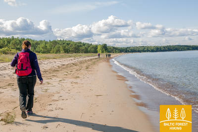
Atkarpa 101. Dubulti - Lielupe - Bulduri.
Populiariausi paplūdimiai Latvijoje
Maršruts piemērots ikviena vecuma un fiziskās sagatavotības gājējam. Starp Dubultiem un Lielupi plešas Rīgas jūras līča platākais smilšu liedags – Jūrmalas kūrorta nozīmīgākā vērtība ar daudzām pludmales kafejnīcām, dažādām atpūtas iespējām. Piekrastes kāpu mežus caurvij blīvs taku tīkls, kas piemērots iešanai un nūjošanai. Jūrtakas daļa starp Lielupes pludmali un Jūrmalas brīvdabas muzeju ietilpst Ragakāpas dabas parkā. No šejienes atpakaļ uz Bulduriem var ērti nokļūt pa Bulduru prospektu un 5. līniju.
Jūrmalas kūrortam ir senas kūrortoloģiskās tradīcijas. Interesanta ir pilsētas vēsturiskā koka apbūve un tās elementi. Apskatāmi daudzi vēsturiski un mūsdienu pieminekļi - muzeji, piemiņas vietas, Jomas iela, vēsturiskās Jūrmalas daļas. Dzintaru koncertzāle - populāra pasākumu norises vieta.