


Baltic Forest Hiking - Valley Dubysa river

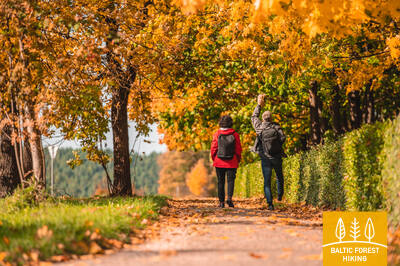
Along the banks of the Dubysa river valley
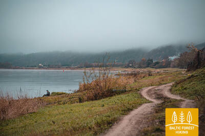
Multicoloured meadows of Lithuania’s most picturesque river valley
Vilkija – Padubysys – Ariogala – Kirkšnovė – Kaulakiai – Šiluva – Tytuvėnai – Aukštiškiai – Dengtiltis: 141 km, 6 days or 7 days.
For a-day-and-a-half walk, the Forest Trail passes through Dubysa Regional Park (Dubysos regioninis parkas), where castle-mounds, historical churches and other testimonies of culture and history dot the riverbanks. The Dubysa is a beautiful river favoured by nature lovers because of its rapid flow. The Dubysa is shallow, water in the river is clear, and campsites and camps have been established on its sandy banks. The Forest Trail passes through the historic settlements of Betygala, Ugionius and Šiluva and finally reaches Tytuvėnai Regional Park. The most valuable natural asset of the park is lakes surrounded by wetlands — an important habitat for many animals and birds, including thousands of cranes. The town of Tytuvėnai is renowned for the Baroque-style Bernardine monastery and church, built in the 17th century. Šiluva is an important Catholic-pilgrimage site.
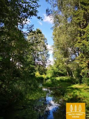
 Section 67. Vilkija – Padubysys.
Between the valleys of two rivers – the Nemunas and the Dubysa
The first kilometre the Forest Trail leads along the very bank of the Nemunas, then turns off the Kaunas–Jurbarkas road (No. 141) and continues on a pedestrian / bicycle path to Ringovė mound. Turning to the right to the north, the Forest Trail crosses a small forest massif (entomological nature reserve for insect protection) and further follows the road No. 1929. After 2 km, the Forest Trail turns left and travels through agricultural lands. Before Lazduoniai village, it crosses the deep valley of the Lazduona river, follows the road No. 1917 for 0.2 km and then turns right to the northwest until it reaches the deep and wide Dubysa river valley. In the next 2 km, the Forest Trail winds along a country road on the left bank of the Dubysa, where you can see rare farmsteads. The river water is clear in summer, the flow is calm and it is interrupted only by the remnants of the former mill dam. Finally, the Forest Trail winds up on the steep bank of the Dubysa river valley and reaches the destination of this section.
 Section 68. Padubysys – Ariogala – Kirkšnovė.
On the way to one of the oldest settlements in Lithuania – Ariogala
Winding on the steep bank of the Dubysa valley, the Forest Trail crosses a small forest for 2.5 km and further 4 km up to Čekiškė through an area where large corn fields bloom in summer. A similar landscape can be seen for the next 9 km, until the Forest Trail crosses the Kaunas–Klaipėda highway (A1) along the bridge. About 1.5 km further, before Gėluva village, the Forest Trail descends into the deep Dubysa valley and winds along small paths and quiet country roads along the bends of the river, revealing wide views of the town of Ariogala at the top of the valley. Along Dubysos and Gedimino streets, it winds up to the town's central street, Vytauto street. Further along Plento street, the Forest Trail 5 km from the centre reaches the point where you have to turn to the end of the section – Krikšnovė pond (another 0.2 km).
Section 69. Kirkšnovė – Kaulakiai.
Through Dubysa Regional Park
About 0.5 km after Kirkšnovė the Forest Trail turns left from the Ariogala–Betygala road (No. 3504) and then up to the destination at the Raseiniai–Baisogala road (No. 225) winds along the bends of the Dubysa river, where floodplain meadows alternate with small forest massifs and little villages. In some places there are vast views of the high banks of the Dubysa valley and the castle mounds. There is a pronounced land relief in this section – the Forest Trail winds up and down the steep slopes of the shores, ensuring a memorable hiking experience. This is a section for hikers – “gourmets”!

Section 70. Kaulakiai – Šiluva.
Dubysa valley and the highest railway bridge in Lithuania
Moving along the Raseiniai–Baisogala road (No. 225) and along its pedestrian sidewalk, the Forest Trail crosses the deep Dubysa valley and turns right at the village of Ginčaičiai. After throwing a wide circle through the surrounding countryside, after 6 km it leads to the Raseiniai–Šiluva road (No. 148) and after about 3 km, crossing the Dubysa valley again, it reaches the Kušeliškė village. For the next 5.5 km, the Forest Trail runs along the Kušeliškė–Lyduvėnai (No. 3516) road, where the famous and scenic Lyduvėnai railway bridge can be seen in the distance. On the bend of the road before the Dubysa motorway bridge, the Forest Trail turns right to the northeast and along the road No. 3544 after 9 km reaches Šiluva, but after another 0.8 km – the centre of the town. At this section, the terrain of the neighbourhood is gradually becoming more pronounced, as it leads to the area where the Dubysa valley alternates with the southern part of the East Žemaitija Upland. The section of the route to Lyduvėnai leads along or nearby the Dubysa Regional Park, but Šiluva is part of the next section – Tytuvėnai Regional Park.
Section 71. Šiluva – Tytuvėnai – Aukštiškiai.
Through the Tytuvėnai Regional Park
From Šiluva to Tytuvėnai, a 7 km long paved pedestrian / bicycle lane leads along the road. The Forest Trail crosses the centre of Tytuvėnai along Šiluvos and Maironio streets, turns to Miško street and continues as a scenic trail along the western shore of Gilius lake. In the northern part of the lake, it turns east along the old railway dam, after about 1.4 km reaches Kuršių street (No. 148) and, following its pedestrian sidewalk, after 0.6 km opposite Budraičiai village turns left to the west. Another 4 km trail leads along a gravel country road until it reaches the final destination of this section – Aukštiškiai.
Section 72. Aukštiškiai – Dengtiltis.
Through the picturesque Šimša Forest
The section of the route leads to the East Žemaitija Upland (also known as East Samogitian Upland). The Forest Trail bends through for 5 km between cultivated fields, crosses the Šiauliai – Tauragė railway line and reaches Kiaunoriai village through small forest roads in Šimša Forest in Tytuvėnai Regional Park. It leads through the village along the main street – Draugystės street, and after 0.5 km turns left to the northwest (road No. 2122); after 4 km it reaches Pašiaušė village. After another 4 km, the Forest Trail descends into the Dubysa valley and turns left, where it meanders along the right bank of the river. After 0.5 km, the route reaches the final destination of the section. Dengtiltis and the next section of the Forest Trail are located in Kurtuvėnai Regional Park.