


Baltic Forest Hiking - North Gauja

Northern Gauja Forestland
MOST UNTOUCHED FOREST REGION OF VIDZEME
Valmiera – Trapene: 123 km, Day 9 – 13
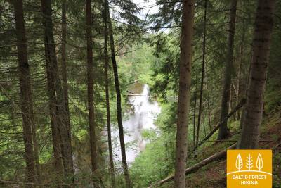
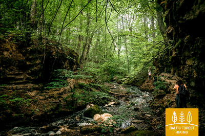
One of the least populated and most densely forested areas on Forest trail. The forests are abundant in mushrooms and berries, birds and wild animals. Here Gauja, the longest river in Latvia, curves along inland dune ranges which are covered in scarce, transparent pine forests. The land is covered in white reindeer moss which enchants the forest with a bright, sun-lit hue. Climb to the peaks of the hills to take in the panorama in its full splendour: river bends, vast meadows and ancient, majestic oak trees. Here you can see the typical Latvian landscape with individual farmsteads enclosed by forests and fields.
Highlights: Park of Senses on the bluffs of the Gauja River – trail in the trees and barefoot trail in Valmiera city, The bridge over the Gauja River next to Strenči, Strenči – a town with ancient rafter traditions, Seda – a town built in socialist urban style, featuring classical architecture of Stalin’s era, Cirgaļi inland dunes and a viewing tower, Castle of Zvārtava – a Neogothic castle built in 1881, Trapene larch alley, Kalamecu - Markūzu ravines – magnificent ravines with waterfalls and a cave-like niche.
 Section 9. Valmiera - Strenči.
Along Abuls to Strenči, the capital of rafters
The trail passes through the historical centre of Valmiera and the Atpūtas Park, which is a popular place among hikers and Nordic walkers, then crosses the suspension bridge, passes Pauku priedes pine forest and Baiļu kalns. From there it follows the Abuls Trail, curving along the banks of the river until reaching the Brenguļi Brewery, and further down, beyond Pūpoli, enters vast, unpopulated forest areas. The first part of this section passes by numerous small summer cottage villages with names such as Enerģētiķis, Saulītes, Sprīdītis, Gaujmaļi, Pūpoli and Gaujaslāči, which were initially established during the Soviet period as summer cottage neighbourhoods of the people of Valmiera and the surrounding territories. Near Ūdriņas, the Forest Trail leads through a labyrinth of the riverbeds and turns north, crossing the Gauja Bridge, where a resting and boating stop is located. The centre of Strenči is located at a 1.5 km distance. Part of the section passes through the Northern Gauja protected landscape area.
Section 10. Strenči - Spicu Bridge.
Through the beautiful forests of Vidzeme
The beginning of the Forest Trail at this section coincides with the Gauja Nature Trail, which runs along the very bank of the river. The Forest Trail crosses the A3 in two places (before the turn to Seda and before Kauči) (be careful!) and continues along small forest roads, a sand-gravel quarry, then continues down a gravel road at the turn to Oliņas. After 3.5 km, turn right again and follow the route to Spicu Bridge via small and remote forest roads where some of the most beautiful sights of the Northern Gauja (“Ziemeļgauja”) protected landscape area can be seen by the so called Zemā sala (Low Isle). A picnic area and a camp are located at the end of this section, where the P24 crosses the Spicu Bridge.
Section 11. Spicu Bridge - Zaķi.
Through the magnificent Cirgaļi dunes
The Forest Trail crosses Spicu Bridge and leads to the four Kokši lakes (about 4 km), which are interconnected by a small stream. Here you will find a picnic area, tent spots and a nature trail for travellers. The surrounding nature is beautiful, and the forests are rich in edible mushrooms. After passing the last of the Kokši lakes, Lake Dibena, in an hour or two you will reach the Cirgaļi dune massif, which you will cross towards north-south. The further section of the Forest Trail crosses a large forested area, and a lone homestead or a smaller lake can be seen here and there. The section ends in a small village named Zaķi. The village provides no services, so be sure to consider the necessary arrangements and accommodation options as you plan your hike. The section is located in the Northern Gauja (“Ziemeļgauja”) protected landscape area.
 Section 12. Zaķi - Gaujiena.
Along Zvārtava Castle to Gaujiena
1.5 km after Zaķi the Forest Trail turns off the Sēļi–Vireši road (P23) and continues on a small rural road all the way to Zvārtava, where Zvārtava Castle awaits at the end of a long alley. Having passed through Zvārtava, the Forest Trail returns to P23 and after a 2 km walk goes up a steep hill, reaching the centre of Gaujiena. A part of the section is located in the Northern Gauja (“Ziemeļgauja”) protected landscape area.
Section 13. Gaujiena - Trapene.
Along Latvia’s longest larch alley to Trapene
The stretch of road between Gaujiena and Līzespasts leads through remote forests, surrounded by large swamps. Mežciems is the only settlement here, and there are no solitary homesteads. Further along, the 5 km walk from Līzespasts to Trapene features open agricultural landscapes with lush meadows and landscapes typical of western Alūksne hillocks. About half of these 5 km lead through the breath-taking Trapene larch alley.