


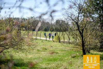
Baltic Forest Hiking - Easy hike


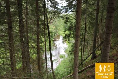
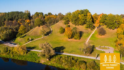
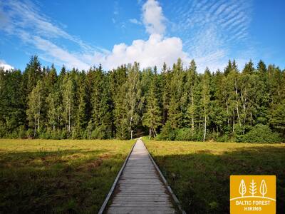
 1-й этап. Старая Рига – Балтэзерс.
Сквозь Ригу – объект Всемирного наследия ЮНЕСКО
В Латвии Лесная тропа начинается в самом сердце Старой Риги – на Ратушной площади. Тропа идет по улице Калькю, мимо Памятника Свободы, через Верманский парк и по исторической улице Тербатас. Далее она устремляется к пешеходному мосту, пересекает железнодорожную станцию «Земитану» и продолжается в Бикерниекском лесу и лесном массиве Шмерлис. Лесная тропа проходит через Юглу, мимо Латвийского этнографического музея под открытым небом и по пешеходно-велосипедным дорожкам приводит в Балтэзерс.

В лесах Бикерниеки и Шмерлиса создан маркированный альтернативный маршрут тропы Межтака длиной 8 км, имеющий форму символа бесконечности. Объединяя его с другими тропами, каждый может выбрать себе легкий маршрут подходящей длины.
 9-й этап. Валмиера – Стренчи.
Вдоль берегов реки Абула – в Стренчи, город плотогонов
Заглянув в исторический центр Валмиеры и Парк отдыха, где созданы трассы для пеших прогулок и скандинавской ходьбы, Лесная тропа пересекает Вантовый мост и уводит к соснам Пауку и горе Байлю. По тропе Абула, пролегающей вдоль крутых первозданных речных берегов, Лесная тропа ведет к пивоварне Бренгелю, и далее, миновав Пуполи, – к малонаселенным местам и обширным лесным массивам. Первая половина этапа представлена небольшими дачными поселками Энергетик, Саулитис, Спридитис, Гауймали, Пуполи и Гауяслачи, созданными в советское время для работников промышленных предприятий Валмиеры и ее окрестностей. В районе Удрини Лесная тропа проходит через лабиринты старых речных долин, поворачивает на север, пересекает мост через Гаую, возле которого находится база отдыха и лодочного спорта. Расстояние отсюда до центра Стренчи составляет около 1,5 км. Часть пути находится в заповедной зоне Северной Гауи.
От так называемого «Дзелзитиса» (бывший узкоколейный железнодорожный мост через Гаую в Валмиере) по правому берегу Гауи до моста на улице Цесу (1,3 км) и далее по обоим берегам до моста Ваншу через Гаую (петля около 3 км) можно совершать короткие походы вдоль берегов Гауи. В парке Атпутас также имеется густая сеть троп для легких прогулок и коротких походов.
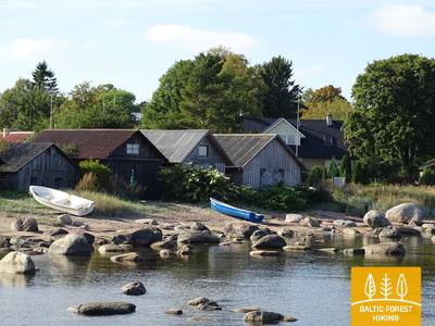
42-й этап. Оанду – Кясму (Käsmu).
Кясму – поселок капитанов и строительства парусников
На участке от Оанду до Вызу (Võsu) Лесная тропа проходит 9 км по территории внутриматериковых, поросших лесом дюн. На некоторых соснах можно видеть надрезы, оставленные сборщиками смолы. В странах Балтии смолу таким способом добывали вплоть до 60-70-х годов 20-го века. Деревья густо покрыты лишайником, что свидетельствует о чистоте воздуха. Осенью вдоль тропы растут грибы и черника. Заглянув в Вызу (популярный курорт), Лесная тропа по прекрасному прибережному лесному променаду приводит в поселок Кясму. Стоит пройти один километр, чтобы посмотреть на камни Вана-Йюри (Vana-Jüri), находящиеся на краю полуострова, а также совершить прогулку по историческим местам Кясму.
Между деревнями Вызу и Кясму, а также в их окрестностях пролегает густая сеть троп, где каждый может выбрать прогулку или поход желаемой продолжительности с возможностью вернуться в исходную точку.
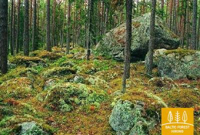
 43-й этап. Кясму (Käsmu) – Вийнисту (Viinistu).
В царстве валунов полуострова Кясму
Первая треть этого этапа Лесной тропы проходит через полуостров Кясму, сказочное место с лесистыми дюнами и заросшими мхом валунами. Возле поселка Эру Лесная тропа преодолевает 2-километровый участок дороги Вызу (Võsu) – Котка, проходит через поселок Вихасоо и выводит на обочину дороги, откуда можно видеть залив Эру и полуостров Кясму. На этом этапе перед путниками предстают величественные ледниковые, входящие в число крупнейших в Национальном парке Лахемаа, – Таммиспеа и Яаани-Тоома Сууркиви (Jaani-Tooma Suurkivi), напоминающие обломки огромной скалы. С побережья в районе Вийнисту хорошо виден остров Мохни с маяком.
Полуостров Кясму испещрен сетью небольших троп, позволяющих совершать прогулки и походы различной продолжительности в зависимости от предпочтений и способностей.
54-й этап. Didžiasalis – Druskininkai – Žiogeliai.
Друскининкай – самый популярный курорт в Восточной Литве
Между деревней Диджясалис и курортом Друскининкай Лесная тропа петляет по хвойным лесам, отличающимся обилием ягод и грибов. Возле Друскининкай Лесная тропа совпадает с маршрутом вдоль реки Неман, огибает комплекс зимних развлечений Сноу Арена в Друскининкай, а затем по пешеходным и велосипедным дорожкам выходит к Парковому мосту через реку Неман. Миновав мост, Лесная тропа пролегает по улице Майронё и далее по небольшим улочкам и парковым аллеям исторического курорта Друскининкай, пересекает небольшую реку Ратнича и лесопарк на правом берегу Немана. За улицей Вейсею маршрут проходит по тротуару улицы Нераву и через приблизительно 1 км поворачивает налево на улицу Соджяус, которая на окраине деревни Неравай превращается в живописную лесную дорожку. Это граница Дзукийского национального парка. Лесная тропа огибает деревню Вечюнай, где перед пешими туристами открывается красивейшая панорама Лишкявского монастыря на противоположном берегу реки Неман. Далее до деревни Жиогяляй Лесная тропа пролегает по красивой и спокойной лесной дорожке.
Город Друскининкай с его парками и прилегающими лесными массивами является подходящим местом для прогулок и коротких походов различной продолжительности.
57-й этап. Nemunaitis – Alytus.
В Алитус по самому высокому пешеходному мосту
Из Нямунайтисa по улице Витауто и шоссе Канюкай–Эйнорай–Нямунайтис (№ 1102) Лесная тропа на протяжении около 1,5 км пролегает в северо-восточном направлении, затем сворачивает влево на север и ещё через 3 км приводит в деревню Гечялаукис. Далее Лесная тропа поворачивает направо в восточном направлении и через 3,3 км снова выходит на шоссе № 1102. Через 3,3 км Лесная тропа достигает шоссе № 128 и по пешеходному тротуару спускается в долину реки Неман. Отсюда, миновав через чуть более 3 км, красивейшая тропа, протянувшаяся в долине Немана, через лес выводит к пешеходному мосту через реку. После значительного подъёма на самый высокий в Литве пешеходный мост, перед глазами открывается широкая и ошеломляющая панорама реки Неман. Миновав мост, Лесная тропа петляет по насыпи бывшей железной дороги, по небольшим дорожкам Курортного парка Алитуса, и в центре города, по улице С. Даряус и С. Гирено, приводит в скверу Старого города, в южной части которого находится туристический информационный центр Алитуса.
Парки и скверы Алитуса подходят для прогулок различной продолжительности, а набережные Немана — для коротких походов.
59-й этап. Panemunis – Birštonas.
Вдоль излучин реки Неман через этнографические хутора
Повторяя излучины реки Неман, Лесная тропа на территории Регионального парка излучин Немана образует изгиб длиной более 20 км, петляя по красивейшим природным уголкам и небольшим деревням с характерными для данной местности деревянными постройками, выкрашенными в разные цвета. Единственный на данном этапе крупный лесной массив, в котором маршрут пролегает по небольшим лесным дорожкам, расположен между деревнями Сипонис и Пузонис. После пересечения шоссе Вильнюс–Мариямполе (A16), Лесная тропа выходит к следующей излучине реки Неман, где располагается бальнеологический курорт Бирштонас. По улице Б. Сруогос тропа приводит к туристическому информационному центру Бирштонаса.
Парки и набережная Бирштонаса, тянущиеся вдоль берега реки Неман, подходят для прогулок разной продолжительности, походов и для родителей с колясками.
60-й этап. Birštonas – Alksniakiemis.
По курорту Бирштонас и городу Пренай
Миновав туристический информационный центр Бирштонаса, Лесная тропа на протяжении более 1 км пролегает по променаду набережной реки Неман, затем сворачивает на улицу Альгирдо, пересекает парк имени Витаутаса Юргиса Мяшки, снова возвращается на набережную и через 0,6 км сворачивает на пешеходную и велосипедную дорожку, на протяжении около 5 км петляющую по лесу Жверинчюса. Вынырнув из леса, маршрут выходит к городу Пренай и к обустроенной рядом с рекой Неман рекреационной зоне. После перехода на другой берег реки Неман по ближайшему мосту, Лесная тропа продолжает петлять по улицам Витауто, Нямуно, Й. Здебскё, Кястучё, Й. Басанавичяус и Кястучё (№ 3306), покидая центральную часть Пренай. По улице Паупё Лесная тропа повторяет излучину реки Неман и через 7 км от центра Пренай сворачивает влево в восточном направлении, на Алкснякемис. Практически весь данный этап проходит по территории Регионального парка дельты Немана.
Набережная реки Нямунас и велопешеходная дорожка, соединяющая Бирштонас с городом Пренай и пересекающая лес Жверинчюс, подходят для прогулок и походов различной продолжительности, а также для родителей с колясками. Она расположена в региональном парке излучин Нямунаса.
64-й этап. Kaunas – Lampėdžiai.
По историческим улицам города Каунаса
Каунас – второй по величине город Литвы, временная столица государства в 1919–1940 гг., культурная столица Европы 2022 г. Лесная тропа пролегает по самой известной улице города, предназначенной только для пешеходов и велосипедистов – обсаженной липами аллее Лайсвес. Аллея протяжённостью более 1,5 м и окрестные улицы отличаются уникальной архитектурой в стиле модернизма. Зданиям, возведённым в 1914–1940 гг., присвоен Знак европейского культурного наследия. Затем маршрут приводит на улицу Вильняус – главную улицу средневекового Каунаса, на которой некогда хозяйничали ганзейские купцы. В старой части города Лесная тропа проходит через Ратушную площадь, мимо различных исторических зданий и костёлов, а затем выводит на побережье Немана в месте слияния крупнейших литовских рек Немана и Нярис, в расположенный здесь парк. Миновав Каунасский замок и перейдя на другой берег реки Нярис, Лесная тропа ещё на протяжении 4 км пролегает по пешеходным и велосипедным дорожкам до бывшего щебневого карьера Лампеджяй. Сейчас карьер заполнен водой, рядом оборудованы пляж и кемпинг, так что в тёплое время года он становится любимым местом отдыха жителей и гостей Каунаса.
ВАЖНЫЙ. На участках, пересекающих город Каунас, разметки нет.
Городские парки, проспект Лайсвес и набережные Немана подходят для прогулок и коротких походов различной продолжительности с удобным использованием городского общественного транспорта.
83-й этап. Paplatelė – Plateliai.
Среди крупнейших озёр Жемайтийского национального парка
Первые 3,5 км Лесная тропа ведёт через красивейшие хвойные леса. До Музея холодной войны тропа совпадает с познавательной тропой Плокштине, а 5 км от музея – с пешеходной и велосипедной дорожкой Плокштине. У шоссе № 3202 (улица Малуно) маршрут сворачивает налево на юго-запад и сразу, через 0,3 км, направо на юго-юго-запад. Приблизительно через 0,5 км выходит на улицу Ильгё эжеро. Затем на протяжении 5,5 км маршрут делает широкий круг вокруг озёр Ильгис и Бержорас, пока не выведет к деревне Бержорас. Через 2 км по улице Плунге Лесная тропа приводит в центр Плателяй и делает ещё один круг по улице Эжеро до познавательной тропы Шейре, открывая живописный ландшафт. Далее по улицам Эжеро, Науёйи и Жямайчю Калвариёс возвращается в центр города.
Вокруг озера Плателяй густая сеть троп. Каждый может выбрать подходящую тропу, небольшую тропинку или тротуар для прогулок и походов разной длины и сложности.
91-й этап. Aizpute – Snēpele.
Тропами барона фон Мантейфеля
Маршрут Лесной тропы улочками Атмодас и Елгава проходит через Айзпуте, за прудом Лажа сворачивает вправо и большой дугой приближается к парку поместья Казданга с южной стороны. Маленькими тропками вдоль озера Дзирнаву ведёт по парку вокруг строений поместья и пруда Зену, 0,7 км проходит дорогой Казданга - Цилду (V1200) и сворачивает вправо на дорогу Снепеле – Казданга (V1296). К усадьбе «Земтури» лесная тропа понемногу поднимается на Бандавские холмы Западно – Куршской возвышенности, откуда открывается красивейший вид окрестностей. Это место находится на высоте 81 м над уровнем моря. От усадьбы 12 км маршрута пролегают через малонаселённые лесистые места, и лишь последние 3 км выводят на открытую местность и фермерские земли, пока не дойдут до Снепеле.
В парке Казданга, который является крупнейшим в Латвии, созданы тропы протяженностью 9 км. Тропы маркированы, доступны файлы GPX, оборудованы места для отдыха. Подробнее: https://www.kurzemesregions.lv/projekti/turisms/unigreen/dabas-takas/kazdangas-parka-dabas-taka/
92-й этап. Snēpele – Kuldīga.
Кулдигa – самый очаровательный средневековый город Курземе
Лесная тропа ведёт по главной улице Снепеле к дороге V1294 и через 0,3 км перед озером Кепшу сворачивает вправо на деревенскую дорогу. По этой дороге маршрут достигает Слипинциемса, перед этим пересекая плотину Спринцупе, и проходит вдоль пруда. Далее маршрут поворачивает по направлению к Пелчи, где петляет вдоль Дамбовых прудов, ведет к дороге Кулдига – Пелчи (V1293) и продолжается через сады Кулдиги «Курземите» и «Румба», до реки Вента и Кулдигской объездной дороги. Этап маршрута длиной 2,4 км от объездной дороги до Старинного кирпичного моста ведёт по красивой прибрежной тропе реки Венты, где во влажных местах и через ручьи проложены деревянные мостки.
Пешеходная тропа вдоль реки Вента в Кулдиге на участке между Рижской объездной дорогой и старым кирпичным мостом через Венту совпадает с тропой Межтака. Ее длина составляет 2,4 км. На маршруте обустроены места для отдыха, информационные стенды и дощатые настилы.
99-й этап. Jāņukrogs – Bigauņciems.
По Кемерскому национальному парку
После пересечения территории с несколькими усадьбами, извилистая Лесная тропа проходит через красивые хвойные леса и еще 6,5 км по Чаукциемсу, пока не сворачивает к Зеленой дюне. Дальше идет по обочине дороги Антинциемс - Смарде. Местность ровная, так как маршрут пролегает по равнине Энгуре в прибрежной низменности. С Зеленой дюны открывается широкий вид на болото Заля (Зеленое) и Ведьмино болото. Небольшая извилистая лесная тропа проходит по нижней части дюны и в двух местах пересекает болото по деревянным мосткам. В Кемери маршрут пролегает по улицам партизану, Робежу, А. Упиша, Катедралес и E.Дарзина через информационный центр национального парка «Meža māja“ и Вершупите, в которую втекают воды серных источников. Маршрут пересекает улицу Туристу и дальше идет по дороге Дуну до озера Слокас. Дальше Лесная тропа доходит до болотистого леска Вершупите - одной из самых лучших сред обитания влажных лесов во всем Курземе. Возле озера Мелнэзерс маршрут сворачивает в сторону старой Кемерской дороги и через 2 км достигает Бигаунциемса. За трассой Слока-Талси (P128) маршрут Лесной тропы доходит до Рижского залива и соединяется с маршрутом тропы Балтийского взморья (E9). Весь этап пути Лесная тропа проходит через Кемерский национальный парк (КНП).
Курортный парк Кемери, окружающий реку Вершупите многочисленными мостиками, дощатая набережная Черноольхового болота (длиной 0,6 км) возле Лесного дома и тропа озера Слокас (3,1 км) подходят для легких и коротких прогулок на природе.

101-й этап. Дубулти – Лиелупе – Булдури.
Самые популярные пляжи Латвии
Между Дубулти и Лиелупе раскинулся самый широкий пляж на побережье Рижского морского залива – главнейшая ценность города-курорта Юрмалы – с многочисленными пляжными кафе и разнообразными возможностями отдыха. Леса в прибрежных дюнах пронизаны плотной сетью тропинок, которые подходят для обычной и скандинавской ходьбы. Часть Тропы Балтийского взморья между пляжем Лиелупе и Юрмальским музеем под открытым небом проходит по территории природного парка «Рагакапас». Отсюда обратно в Булдури можно легко попасть по проспекту Булдуру и 5-й линии.
Юрмала идеально подходит для легких и коротких походов по песчаному пляжу, по дюнам, покрытым сосновым лесом (сеть троп) или по пешеходным улицам и паркам города. Вы можете выбрать различную продолжительность пеших прогулок, совмещая их с поездками на поезде (расстояние между остановками: 1,5 - 2 км) или городскими автобусами.