


Baltic Forest Hiking - Veclaicene Forestland

Veclaicene Forestland
MOST BEAUTIFUL NORTH LATVIAN HIGHLANDS
Trapene – Korneti: 44 km, Day 14 – 15
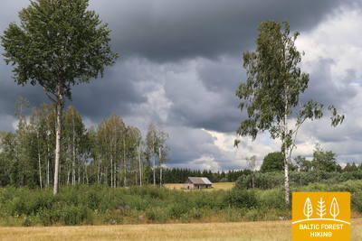
Forest trail stretches over the hillocks of Alūksne. This is one of the most difficult hiking sections, since the area is hilly. There are many glacial ravines and hills featuring panoramic views stretching all the way to Estonia and Munamägi. The highest hills are castle hills with thousands of years of history, which were purposefully selected for their high ground so that any hostile armies could be seen far away. In this section, Forest trail takes a small detour through Paganamaa or Devil’s Land in Estonia, where hikers will find a viewing tower overlooking the picturesque forest lakes. The scenery is most beautiful in spring, when dandelions are in bloom, and in autumn, as leaves turn red.
Highlights: Landscapes of Alūksne hillocks with hills and lakes, Historical centre of Ape – dolomite buildings and cobblestones, Kornetu - Peļļu subglacial bed – one of the most impressive in Latvia, Drusku castle mound and Dzērve hill watchtower, Witches’ Cliffs on the bank of the Vaidava River.
 Section 14. Trapene - Ape.
Towards Ape, where witches used to reside on the banks of Vaidava River
The first 6 kilometres of the Forest Trail lead along P44 until it turns North on the Ādams–Ape road. 4 km before the Riga–Pskov motorway (A2), the Forest Trail passes through a magnificent, dense forest, which is a popular spot for foraging berries and mushrooms in Autumn. After the Riga–Pskov highway, the Forest Trail runs through agricultural lands until it reaches the centre of Ape, one of the smallest towns in Latvia, after crossing the former Ape–Valka narrow-gauge railway line.
 Section 15. Ape – Paganamaa – Korneti – Latvian/Estonian border.
Through the Korneti-Peļļi Furrow and the Paganamaa or Devil's Land
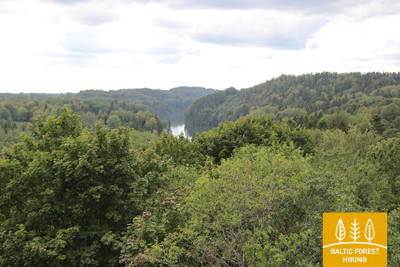
After leaving Ape, the Forest Trail winds through a hilly farmland landscape, then enters a dark forest massive, occasionally interrupted by the blue surfaces of lakes. After Peļļi, the Forest Trail moves down the same path as Peļļi trail, crosses the Latvian/Estonian border and winds along the shores of Lakes Smilšājs, Sūneklis and Ilgājs for 2 km on the Estonian side, known as Paganamaa (translation: Devil's Land). There it descends and enters the Korneti-Peļļi subglacial depression, one of the most impressive ravines in Latvia. The Forest Trail returns to Latvia at Ilgājs and, after a steep climb, takes you through a hilly area to the Drusku castle mound. The Forest Trail descends in Korneti. It is less than 3 km from the centre of Korneti to the Latvian/Estonian border. Features beautiful landscapes on the banks of Lake Lielais Baltiņš and Lake Mazais Baltiņš along the route. The section is located in the protected landscape area “Veclaicene”.