


Section 70. Kaulakiai – Šiluva. Along the banks of the Dubysa river valley.
Section 70. Kaulakiai – Šiluva.
Kaulakiai – Šiluva Dubysa valley and the highest railway bridge in Lithuania
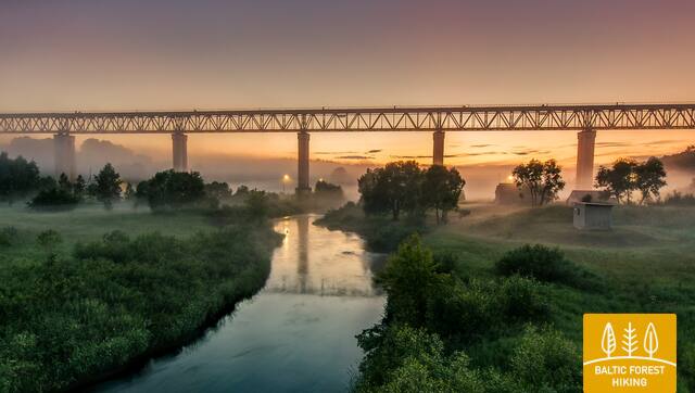
Moving along the Raseiniai–Baisogala road (No. 225) and along its pedestrian sidewalk, the Forest Trail crosses the deep Dubysa valley and turns right at the village of Ginčaičiai. After throwing a wide circle through the surrounding countryside, after 6 km it leads to the Raseiniai–Šiluva road (No. 148) and after about 3 km, crossing the Dubysa valley again, it reaches the Kušeliškė village. For the next 5.5 km, the Forest Trail runs along the Kušeliškė–Lyduvėnai (No. 3516) road, where the famous and scenic Lyduvėnai railway bridge can be seen in the distance. On the bend of the road before the Dubysa motorway bridge, the Forest Trail turns right to the northeast and along the road No. 3544 after 9 km reaches Šiluva, but after another 0.8 km – the centre of the town. At this section, the terrain of the neighbourhood is gradually becoming more pronounced, as it leads to the area where the Dubysa valley alternates with the southern part of the East Žemaitija Upland. The section of the route to Lyduvėnai leads along or nearby the Dubysa Regional Park, but Šiluva is part of the next section – Tytuvėnai Regional Park.


