


Baltic Coastal Hiking trail - For visually impaired

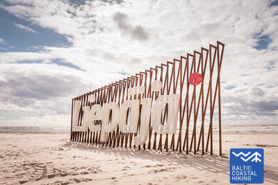
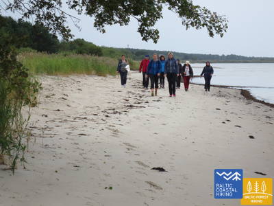
 Section 3. Bernāti - Liepāja - Karosta (The War Port).
The City Where The Wind Is Born
From Bernāti to Liepāja, the Baltic Coastal Hiking Route leads through a wide beach where initially the coast is formed by washed away shores, but as you approach Liepāja high foredunes covered in sand ryegrass and marram grass appear in sight. Later the trail winds through the old town of Liepāja and “New Liepāja”, crossing the Naval Port Canal to reach the Naval Port: a complex of military and fortification buildings the visitation of which is likely to take a half day. You should certainly try the special dish of Liepāja called Liepājas menciņi made of smoked cod according to an ancient recipe from Southern Kurzeme.
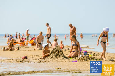
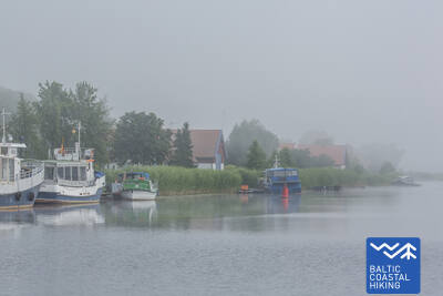
Liepāja Beach near the Central Rescue Station
At Liepāja Beach near the Central Rescue Station (GPS: 56.504199, 20.991922), a facility for people with disabilities has been set up. It includes showers, changing rooms, and wooden boardwalks that extend to the sea, allowing wheelchair users to reach the shoreline. Special wheelchairs suitable for swimming in the sea are available. For blind and visually impaired individuals, audio buoys are placed in the sea to provide information via signals on how far one can swim.


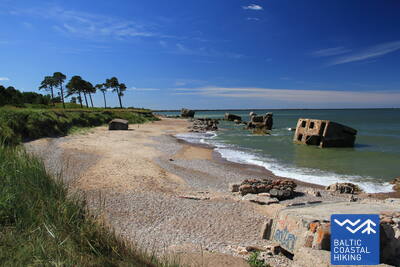
 Section 4. Karosta (The War Port) - Ziemupe.
Karosta - Military Heritage On The Coast Of The Baltic Sea
The first four kilometers of the Baltic Coastal Hiking Route may interest military history enthusiasts with the remains of many forts and coastal defense batteries, but in terms of walking, this is technically the most complicated section of Kurzeme seacoast. After crossing the Fortress Canal, the Baltic Coastal Hiking Route winds through a coastal meadow for a short while, then darts onto a beach and continues as far as Ziemupe. The beach is wide, in times of stronger winds it gets narrower between the Lenkupe and Kārļupīte Rivers. In some places, there are small bluffs, the rest of the section is composed of high, occasionally washed away foredunes. It is said that a lot of ships have sunk in the depths of the Ziemupe River, one of them even had bronze cannons.
Paths at Dvēseles Veldzes Dārzs
The Dvēseles Veldzes Garden (GPS: 56.728534, 21.092676) features two short nature trails designed for visually impaired and blind individuals—the Barefoot Trail (530 m), the Sensory Park, and a Labyrinth. The surface of the Barefoot Trail changes every 10 meters and includes obstacles of varying difficulty. The site offers a designated parking lot, an accessible restroom, tactile objects, audio information, and information in Braille. It is located approximately 2.5 km from the Coastal Trail.


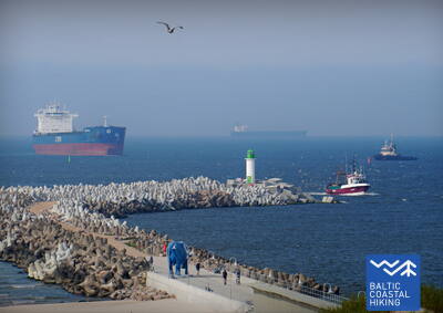
 Section 10. Ventspils - Staldzene.
Through Ventspils
The itinerary goes through Ventspils and its surrounding forests. The Baltic Coastal Hiking Route winds from the South Pier through the historic Ostgals and the Old Town, crosses the Venta River and continues through the Pārventa District via a pedestrian and cyclist path in the direction of Staldzene where it circles the Ventspils Port and then returns to the seacoast. It is worth taking one “day off” and get to know the most interesting places in the city, as well as visit the Seaside Open-Air Museum.
Lake Būšnieki Nature Trail
The trail around Lake Būšnieki is a 9 km loop, accessible for wheelchair users and parents with strollers. It features an audio guide, tactile information, and a parking area for people with mobility impairments. A recommended starting point is the parking lot on the southeast side of the lake (GPS: 57.437632, 21.656062). The trail is located approximately 1 km from the Jūrtaka trail.


Section 17. Ģipka - Kaltene.
The Rocky Beach of Kurzeme
A sandy beach that is not too wide and has beautiful dunes and coastal pine forests stretches from Ģipka to Roja, but before reaching Roja it is overgrown with reeds. Conversely, the section between Roja and the Kaltene Church is one of the most extraordinary parts of the seashore of Latvia, where the coast is notched by small capes and coves with a very narrow beach. All over the coast, there are piles of boulders of different sizes with the green foliage of black alders hanging over them. In some places, the large gnarled root systems of the trees washed ashore rise before your eyes. In some places, an unpaved road goes right along the coast and a lot of former fishermen homesteads are aligned next to it.
Walking Path at Roja Beach
The wooden boardwalks are designed for wheelchair users and parents with strollers. There is an information stand in Braille and a tactile beach map. Facilities include an adapted WC and a parking lot (GPS: 57.510088, 22.799207). The boardwalk is 0.5 km long in one direction. While wheelchair users can use the boardwalks, they cannot reach the sea due to the lack of a ramp. The boardwalks are wide, with guardrails on the sides and passing areas.
Section 21. Ragaciems - Dubulti.
The Historic Resort of Jūrmala
In Ragaciems village, you can clearly see the whole length of the Jūrmala coast. The first third of this day's itinerary is part of the Ķemeri National Park where you can get to know historic fishing villages, the Ragaciems village fishing area with net huts and a fish market, dune habitats, as well as watch birds in the estuary of the Starpiņupe River. Starting from Jaunķemeri to Dubulti, the walk takes you across the widest sandy beach of the Gulf of Riga through the historic resort in Jūrmala and the longest city in Latvia. Keep in mind that on warm and sunny summer days there will be a lot of beachgoers.
The Dubulti Coastal Dunes Trail
Along the Jūrmala coastline, in the dune zone from Baznīcas Street in Dubulti to Amatas Street in Pumpuri, a nature trail about two kilometres long has been created. It is intended for peaceful recreation, getting to know the surrounding environment, and various movement activities.
The trail is convenient for walking enthusiasts, Nordic walkers, and runners alike. Along the route you can experience the characteristic coastal dune landscape and its changing terrain.
Along the way, there are boundary elements, three rest benches, a wooden-deck area with a picnic table and seating, a viewing platform, and a terrace with a stretched net. There is also a special sensory section where you can feel different natural materials — sand, pebbles, and pinecones. Two outdoor exercise machines are placed along the trail, offering the opportunity to move and work out. The route is equipped with signs, as well as information stands about local nature, healthy lifestyles, and the importance of physical activity for human well-being.
The information stands on the Wellness Nature Trail include tactile maps for people with visual impairments. Using touch, they allow visitors to understand the trail, its placement in relation to the surrounding streets, and the maps also include information in Braille.
The map design and production were created by the company Socintegra, which specialises in providing a wide range of environmental accessibility services.
An audio guide about the trail is available in the Izi.Travel app (“Labsajūtas dabas taka / Wellness Nature Trail”) in Latvian and English, allowing users to listen to the information from the trail’s info stands in audio format.


Section 22. Dubulti - Lielupe - Bulduri.
The Most Popular Beaches in Latvia
The widest sandy beach of the Gulf of Riga stretches from Dubulti to the Lielupe River. It is the main asset of the Jūrmala resort offering many beach cafés and different recreational possibilities. The coastal dune forests are permeated with a dense web of trails suitable for walking and stick-walking. The part of the Baltic Coastal Hiking Route located between the beach of the Lielupe River and Jūrmala beach is part of the Ragakāpa Nature Park. From here, you can easily get back to Bulduri by taking Bulduri prospekts and the 5th line.
The Dubulti Coastal Dunes Trail
Along the Jūrmala coastline, in the dune zone from Baznīcas Street in Dubulti to Amatas Street in Pumpuri, a nature trail about two kilometres long has been created. It is intended for peaceful recreation, getting to know the surrounding environment, and various movement activities.
The trail is convenient for walking enthusiasts, Nordic walkers, and runners alike. Along the route you can experience the characteristic coastal dune landscape and its changing terrain.
Along the way, there are boundary elements, three rest benches, a wooden-deck area with a picnic table and seating, a viewing platform, and a terrace with a stretched net. There is also a special sensory section where you can feel different natural materials — sand, pebbles, and pinecones. Two outdoor exercise machines are placed along the trail, offering the opportunity to move and work out. The route is equipped with signs, as well as information stands about local nature, healthy lifestyles, and the importance of physical activity for human well-being.
The information stands on the Wellness Nature Trail include tactile maps for people with visual impairments. Using touch, they allow visitors to understand the trail, its placement in relation to the surrounding streets, and the maps also include information in Braille.
The map design and production were created by the company Socintegra, which specialises in providing a wide range of environmental accessibility services.
An audio guide about the trail is available in the Izi.Travel app (“Labsajūtas dabas taka / Wellness Nature Trail”) in Latvian and English, allowing users to listen to the information from the trail’s info stands in audio format.
Section 31. Ikla - Kabli.
Along the Paths of the Historic Resort
Ikla is the start of the Baltic Coastal Hiking Route in Estonia. In the section connecting Ikla and Treimani, the route leads you along the old Pärnu–Riga road as meadows and reeds stretch across the seashore. After passing Treimani, the trail turns towards the sea and the next 2,8 km are covered across a narrow, sandy or rocky and occasionally thickly overgrown beach. After bypassing the Orajõe Brook, next to the parking lot the trail returns to the beach followed by a hike of ~ 4 km to Hotel Lepanina. There you will have to return to the old Pärnu–Riga road leading you to Kabli. Several good birdwatching sites are located on the itinerary. The coastal area up to Pärnu is a popular relaxation and swimming area.
Kabli
In 2024/2025, a trail with informational stands and an audio guide tailored for individuals with visual impairments is planned to be created in Kabļi. It will be located along the Coastal Trail.
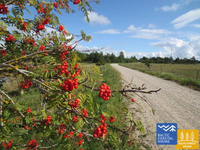
Section 38. Tõstamaa - Matsi.
Pastoral Idyll of Estonia
In this section of the Baltic Coastal Hiking Route, you will see a traditional rural landscape. The littoral is notched by shallow coves, peninsulas and capes surrounded by coastal meadows, reeds, shallow lagoons, marshes, as well as hard to access islands. When walking along the small country roads, overhung by red rowans in autumn, you can see ethnographic-like individual farmsteads and farms with cows and goats. The landscapes of farmsteads interchange with the remains of rock fences, farmland and juniper forests. Access to the sea and rest areas are located south of Ranniku and near Kastna village.
Matsi Port
The trail introduces visitors to the former Matsi fishing port. It is 500 meters long (round trip). The trail starts at the parking lot (GPS: 58.360251, 23.746683). The surface includes asphalt, concrete, and gravel. In windy conditions, the trail may be covered with sand, so wheelchair users might need assistance. The trail features tactile objects and information in Braille. An accessible WC is available. It is located next to the Jūrtaka.


Section 39. Matsi - Varbla.
Beaches and Forests
Matsi beach is one of the rare sandy beaches in the subsequent section of the trail leading to Haapsalu. The Baltic Coastal Hiking Route takes you on a small stroll through Kulli village and for the next 5 km leads you along small trails surrounded by wide forests and dunes. In autumn, their surroundings are rich in berries and mushrooms. After bypassing Uue-Varbla Manor, the trail reaches Varbla village.
Matsi Port
The trail introduces visitors to the former Matsi fishing port. It is 500 meters long (round trip). The trail starts at the parking lot (GPS: 58.360251, 23.746683). The surface includes asphalt, concrete, and gravel. In windy conditions, the trail may be covered with sand, so wheelchair users might need assistance. The trail features tactile objects and information in Braille. An accessible WC is available. It is located next to the Jūrtaka.
Section 70. Rusnė – Šilutė.
Šilutė – a charming authentic town
In the Village of Rusnė, the Baltic Coastal Hiking Route follows Taikos Street and Kuršmarių Street, crossing the Atmata River, a distributary of the Nemunas Delta, over the Rusnė Bridge. Then the trail follows the side of the road as a separate lane, continuing on to Šilutė. Shortly before reaching Šilutė, hikers will have to walk on the side of the road. In Šilutė, you will cross the historical bridge over the Šyša River. Rusnė Street, which connects Rusnė Island and Šilutė, brings you right into the center of the town. Up until Šilutė, the Baltic Coastal Hiking Route leads through the Nemunas Delta Regional Park where vast areas of the lower reaches of the Nemunas River flood in springtime — today these areas are agricultural land and swamp forests (Žalgiriai Forest).
Šilute
The two central city streets—Lietuvininkų Street and Tilžės Street—are equipped with tactile guidance lines for people with visual impairments. This allows for a route through the city of approximately 1.5 kilometers. It is located near the Coastal Trail.
Section 71. Šilutė – Ventė.
Through Nemunas Delta Regional Park
Along Klaipėdos Street and Aukštumalės Street, the Baltic Coastal Hiking Route leaves the town of Šilutė in the direction of Kintai (Road No. 4217), briefly following the top of the polder dike (offering a good view of the Nemunas Delta lowland which floods in springtime), it then snakes along a rural road and returns back on to Aukštmalės Street (Road No. 4217). After less than 6 km, at the intersection in the Village of Rūgailiai the Baltic Coastal Hiking Route loops leftward towards Minija, and after 1.5 km it bears right, returning back on to the Šilutė–Kintai road. The Baltic Coastal Hiking Route crosses the Minija River and the Kintai Carp Lakes over a high and long bridge. From here, you will have one of the most spectacular views of the Lithuanian coastline with an expansive panorama of lowlands and waters. Before reaching the Village of Povilai, the trail turns left, leading through agricultural land for about 5 km where birds can be observed during migration season. Then the Baltic Coastal Hiking Route turns on to a beachside road (Marių Street, Road No. 2201) which leads to the Ventė Cape 5 km away. This scenic section of the route offers expansive views of the Curonian Spit across the Curonian Lagoon (the width of the gulf here is 8–9 km). Hikers can also enjoy the former fishing villages with their colourful, decorated buildings. This section of the trail is part of the Nemunas Delta Regional Park.
Šilute
The two central city streets—Lietuvininkų Street and Tilžės Street—are equipped with tactile guidance lines for people with visual impairments. This allows for a route through the city of approximately 1.5 kilometers. It is located near the Coastal Trail.