


Jūrtaka - Pielāgots redzes ierobežojumiem

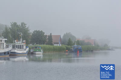
 3. posms. Bernāti - Liepāja - Karosta.
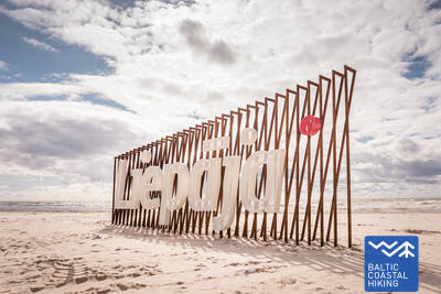
Pilsēta, kurā piedzimst vējš
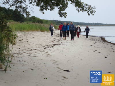
No Bernātiem līdz Liepājai Jūrtaka ved pa platu liedagu, kur sauszemes pusē sākotnēji ir vērojami noskaloti krasti, bet, tuvojoties Liepājai, augstas priekškāpas, apaugušas ar smiltāju kāpukviešiem un kāpuniedrēm. Tālāk tā izlīkumo cauri Liepājas vecpilsētai un Jaunliepājai un, šķērsojot Karostas kanālu, nonāk līdz Karostai - militāro un fortifikācijas būvju kompleksam, kuras apskatei ir vērts ieplānot vismaz pusi dienas. Noteikti jānogaršo Liepājas īpašais ēdiens – ”Liepājas menciņi”, kas gatavots no kūpinātas mencas pēc senas Dienvidkurzemes receptes.
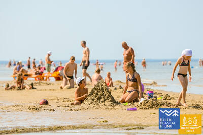
Liepājas pludmale pie Centrālās glābšanas stacijas
Liepājas pludmalē pie Centrālās glābšanas stacijas (GPS: 56.504199, 20.991922) ir izveidots komplekss cilvēkiem ar funkcionaļiem traucējumiem - ierīkotas dušas, pārģērbšanās telpas, koka laipas ved līdz pašai jūrai, tādēļ cilvēki ar ratiņkrēsliem var nokļūt līdz pašai jūrai. Ir pieejami īpaši ratiņkrēsli, kas piemēroti peldēm jūrā. Neredzīgiem un vājredzīgiem cilvēkiem jūrā ir izvietotas audiobojas, kas ar signāla palīdzību sniedz informāciju - cik tālu var peldēt.


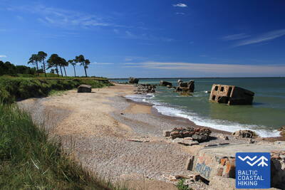
 4. posms. Karosta - Ziemupe.
Karosta - militārais mantojums pie Baltijas jūras
Pirmie četri Jūrtakas kilometri ar daudzu fortu un krasta aizsardzības bateriju paliekām var interesēt militārās vēstures entuziastus, taču no iešanas viedokļa tas ir tehniski sarežģītākais Kurzemes piekrastes posms. Aiz Cietokšņa kanāla Jūrtaka īsu brīdi izlokās pa piekrastes pļavu, tad izskrien liedagā un turpinās līdz pat Ziemupei. Liedags ir plats, stiprāka vēja laikā - ar sašaurinājumu starp Lenkupi un Kārļupīti. Dažviet nelieli stāvkrasti, pārējās vietās – augstas, vietām noskalotas priekškāpas. Stāsta, ka Ziemupes selgā nogrimuši daudzi kuģi, viens pat ar bronzas lielgabaliem.
Dvēseles veldzes dārzs
Dārzā ir izveidotas 2 īsas dabas takas, kas pielāgotas vājredzīgajiem un neredzīgajiem - Baso pēdu taka (530 m), Sajūtu parks un Labirints. Baso pēdu takā ik pēc 10 m mainās segums, kas mijas ar dažādu grūtības pakāpju šķēršļiem. Izveidota speciāla autostāvvieta, pielāgota WC, pieejami taktilie objekti, audioinformācija un informācija Braila rakstā. Atrodas ap 2,5 km no Jūrtakas.


 10. posms. Ventspils - Staldzene.
Cauri Ventspilij!
Maršruts ved cauri Ventspilij un tās apkārtnes mežiem. Jūrtaka no Dienvidu mola izlīkumo cauri vēsturiskajam Ostgalam un Vecpilsētai, šķērso Ventu un tālāk cauri Pārventai pa gājēju – veloceliņu turpinās Staldzenes virzienā, kur, apmetusi loku ap Ventspils ostu, atkal atgriežas jūras krastā. Ir vērts paņemt vienu "brīvdienu" un iepazīt pilsētas interesantākās vietas, kā arī apmeklēt Piejūras brīvdabas muzeju.
Būšnieku ezera dabas taka
Veidota apkārt Būšnieku ezeram 9 km garumā. Taka ir pielāgota cilvēkiem ar ratiņkrēsliem un vecākiem ar bērnu ratiem Ir izveidots audiogids, taktīlā informācija un autostāvvieta cilvēkiem ar kustību traucējumiem. Piemērota vieta uzsākšanai ir autostāvlaukums Būšnieku ezera DA pusē (GPS: 57.437632, 21.656062). Līdz Jūrtakai (tuvākā vieta) ir aptuveni 1 km.


17. posms. Ģipka - Kaltene.
Kurzemes akmeņainā jūrmala
No Ģipkas līdz Rojai stiepjas smilšaina, ne pārāk plata pludmale ar skaistām kāpām un piekrastes priežu mežiem, bet pirms Rojas – tā ir aizaugusi ar niedrēm. Savukārt, posms starp Roju un Kaltenes baznīcu ir savdabīgākais visā Latvijas piekrastē, kur jūras krasts ir izrobots ar maziem zemesragiem un līcīšiem ar ļoti šauru pludmali, kuru viscaur klāj dažādu izmēru laukakmeņu krāvumi, virs kuriem līkst melnalkšņu zaļā lapotne. Dažviet krastā slejas izskaloto koku plašās sakņu rozetes. Vietām gar pašu krastu iet zemes ceļš, gar kuru rindojas daudzas bijušās zvejnieku sētas. Maršruts piemērots aktīviem un izveicīgiem gājējiem!
Lībiešu valodā Ģipka senais nosaukums Gipk.
Laipas Rojas kāpās
Koka laipas ir pielāgotas cilvēkiem ratiņkrēslos un vecākiem ar bērniem. Ir izveidots informatīvais stends Braila rakstā un pludmales taktīlā karte, pielāgota WC un autostāvvieta (GPS: 57.510088, 22.799207). Laipu garums vienā virzienā - 0,5 km. Cilvēki ratiņkrēslos var izmantot laipas, bet līdz jūrai nevar tikt, jo nav nobrauktuves. Laipas ir platas, ar aizsargvalnīti malās un samainīšanās laukumiem.
21. posms. Ragaciems - Dubulti.
Vēsturiskais Jūrmalas kūrorts
No Ragaciema labi redzams Jūrmalas krasts visā tā garumā. Šīs dienas posma pirmā trešdaļa ietilpst Ķemeru Nacionālajā parkā, kur var iepazīt vēsturiskos zvejniekciemus, Ragaciema sedumu un zivju tirdziņu, kāpu biotopus, kā arī vērot putnus Starpiņupītes grīvā. No Jaunķemeriem līdz pat Dubultiem gājiens norit pa Rīgas jūras līča platāko smilšu pludmali, cauri Jūrmalas vēsturiskajam kūrortam un Latvijas garākajai pilsētai. Skaistās un siltās vasaras dienās jārēķinās ar daudzajiem pludmales apmeklētājiem.
Labsajūtas dabas taka
Jūrmalas piekrastē, kāpu joslā no Baznīcas ielas Dubultos līdz Amatas ielai Pumpuros, aptuveni divu kilometru garumā izveidota dabas taka, kas paredzēta mierīgai atpūtai, iepazīšanai ar apkārtējo vidi un dažādām kustību aktivitātēm.
Taka ir ērti izmantojama gan pastaigu cienītājiem, gan nūjotājiem un skrējējiem. Maršrutā var izjust piejūras kāpu raksturīgo ainavu un mainīgo reljefu.
Ceļā izvietoti norobežojoši elementi, trīs atpūtas soliņi, koka seguma laukums ar piknika galdu un sēdvietām, skatu platforma un terase ar izstieptu tīklu. Ir arī īpašs sensorais posms, kurā var sajust dažādus dabas materiālus — smiltis, oļus un čiekurus. Takas vidē izvietoti divi trenažieri, kas dod iespēju izkustēties un izvingroties. Maršruts aprīkots ar norādēm, kā arī informatīviem stendiem par vietējo dabu, veselīgu dzīvesveidu un fizisko aktivitāšu nozīmi cilvēka pašsajūtai.
Labsajūtas dabas takā esošie informatīvie stendi ir papildināti ar taktilām kartēm cilvēkiem ar redzes traucējumiem. Izmantojot tausti, tie ļaus iegūt priekšstatu par taku, tās izvietojumu attiecībā pret apkārtnes ielām un uz kartes ir izvietota informācija braila rakstā.
Karšu dizainu veidoja un kartes izgatavoja kompānija "Socintegra", kas specializējas plaša spektra vides pielāgošanas pakalpojumu sniegšanā.
Par taku ir pieejams audio gids aplikācijā Izi.Travel. (Labsajūtas dabas taka / Wellness nature trail) latviešu un angļu valodās un ar tā palīdzību ir iespējams audio formātā noklausīties informāciju, kas izvietota uz takas informatīvajiem stendiem.


22. posms. Dubulti - Lielupe - Bulduri.
Populārākās Latvijas pludmales
Maršruts piemērots ikviena vecuma un fiziskās sagatavotības gājējam. Starp Dubultiem un Lielupi plešas Rīgas jūras līča platākais smilšu liedags – Jūrmalas kūrorta nozīmīgākā vērtība ar daudzām pludmales kafejnīcām, dažādām atpūtas iespējām. Piekrastes kāpu mežus caurvij blīvs taku tīkls, kas piemērots iešanai un nūjošanai. Jūrtakas daļa starp Lielupes pludmali un Jūrmalas brīvdabas muzeju ietilpst Ragakāpas dabas parkā. No šejienes atpakaļ uz Bulduriem var ērti nokļūt pa Bulduru prospektu un 5. līniju.
Labsajūtas dabas taka
Jūrmalas piekrastē, kāpu joslā no Baznīcas ielas Dubultos līdz Amatas ielai Pumpuros, aptuveni divu kilometru garumā izveidota dabas taka, kas paredzēta mierīgai atpūtai, iepazīšanai ar apkārtējo vidi un dažādām kustību aktivitātēm.
Taka ir ērti izmantojama gan pastaigu cienītājiem, gan nūjotājiem un skrējējiem. Maršrutā var izjust piejūras kāpu raksturīgo ainavu un mainīgo reljefu.
Ceļā izvietoti norobežojoši elementi, trīs atpūtas soliņi, koka seguma laukums ar piknika galdu un sēdvietām, skatu platforma un terase ar izstieptu tīklu. Ir arī īpašs sensorais posms, kurā var sajust dažādus dabas materiālus — smiltis, oļus un čiekurus. Takas vidē izvietoti divi trenažieri, kas dod iespēju izkustēties un izvingroties. Maršruts aprīkots ar norādēm, kā arī informatīviem stendiem par vietējo dabu, veselīgu dzīvesveidu un fizisko aktivitāšu nozīmi cilvēka pašsajūtai.
Labsajūtas dabas takā esošie informatīvie stendi ir papildināti ar taktilām kartēm cilvēkiem ar redzes traucējumiem. Izmantojot tausti, tie ļaus iegūt priekšstatu par taku, tās izvietojumu attiecībā pret apkārtnes ielām un uz kartes ir izvietota informācija braila rakstā.
Karšu dizainu veidoja un kartes izgatavoja kompānija "Socintegra", kas specializējas plaša spektra vides pielāgošanas pakalpojumu sniegšanā.
Par taku ir pieejams audio gids aplikācijā Izi.Travel. (Labsajūtas dabas taka / Wellness nature trail) latviešu un angļu valodās un ar tā palīdzību ir iespējams audio formātā noklausīties informāciju, kas izvietota uz takas informatīvajiem stendiem.
31. posms. Ikla - Kabli.
Pa vēsturiskā kūrorta takām!
Ikla ir Jūrtakas sākums Igaunijā. Ikla – Treimani posmā tā ved pa tā saukto veco Rīgas ceļu, jo jūras krastā plešas pļavas un niedrāji. Aiz Treimani maršruts pagriežas uz jūras pusi un turpmākie 2,8 km ved pa šauru, smilšainu, vai akmeņainu un vietām stipri aizaugušu liedagu. Apmetot loku apkārt Orajõe strautam, pie autostāvvietas tā atkal atgriežas liedagā, pa kuru seko gājiens ~ 4 km garumā līdz Lepanina hotelim, kur atkal jāatgriežas uz vecā Rīgas ceļa, kas aizved līdz Kabli. Maršrutā labas putnu vērošanas
vietas. Piekrastes posms līdz Pērnavai ir populāra atpūtas un peldvieta. Maršruts piemērots ikviena vecuma un sagatavotības gājējam, kam interesē piekrastes kūrorta, zvejniecības un kuģniecības vēsture.
Kabli
2024./2025.g. Kabļos plānots izveidot taku ar informācijas stendiem un audiogidu, kas pielāgoti cilvēkiem ar redzes traucējumiem. Atrodas uz Jūrtakas.
38. posms. Tõstamaa - Matsi.
Igaunijas lauku idille
Šajā Jūrtakas posmā redzama tradicionāla lauku ainava. Piekrasti izrobo daudzi sekli līči, pussalas, zemesragi, kurus ieskauj piejūras pļavas, niedrāji, seklas lagūnas, purvāji, kā arī grūti pieejamas salas. Ejot pa mazajiem lauku ceļiem, pār kuriem rudeņos nolīkuši sarkanie pīlādži, redzamas etnogrāfiska izskata viensētas, lauku saimniecības ar govīm un kazām. Lauku sētas ainavā mijas ar akmens žogu paliekām, lauksaimniecības zemēm un kadiķu audzēm. Pieeja jūrai un atpūtas vietas ir uz dienvidiem no Ranniku un pie Kastna ciema.
Matsi ostas taka
Taka iepazīstina ar kādreizējo Matsi zvejas ostu. Garums - puskilometrs (turp - atpakaļ). Tās sākums ir autostāvlaukums (GPS: 58.360251, 23.746683). Segums: asfalts, betons, grants šķembu segums. Vējainā laikā taka var būt appūsta ar smiltīm, tādēļ cilvēkam ar ratiņkrēslu var būt nepieciešama asistenta palīdzība. Takā ir izvietoti taktīlie objekti un informācija Braila rakstā. Ir pielāgota WC. Atrodas blakus Jūrtakai.


39. posms. Matsi - Varbla.
Pludmale un meži!
Matsi pludmale ir viena no retajām smilšainajām pludmalēm takas turpmākajā posmā līdz Hāpsalai. Jūrtaka izmet loku caur Kulli ciemu un turpmākos 5 km ved pa maziem, plašu mežu un kāpu ieskautiem ceļiem, kuru apkaime rudeņos ir bagāta ar ogām un sēnēm. Apmetusi loku apkārt Uue-Varbla muižai, taka sasniedz Varbla ciemu.
Matsi ostas taka
Taka iepazīstina ar kādreizējo Matsi zvejas ostu. Garums - puskilometrs (turp - atpakaļ). Tās sākums ir autostāvlaukums (GPS: 58.360251, 23.746683). Segums: asfalts, betons, grants šķembu segums. Vējainā laikā taka var būt appūsta ar smiltīm, tādēļ cilvēkam ar ratiņkrēslu var būt nepieciešama asistenta palīdzība. Takā ir izvietoti taktīlie objekti un informācija Braila rakstā. Ir pielāgota WC. Atrodas blakus Jūrtakai.
70. posms. Rusnė – Šilutė.
Šilute – autentiska mazpilsēta ar šarmu
Rusnė ciemā pa Taikos un Kuršmarių ielām Jūrtaka šķērso Rusnes tiltu pāri Atmatas upei, kas ir viena no Nemunas deltas attekām. Tālāk Jūrtaka stiepjas gar ceļa malu kā atsevišķi atdalīta josla un turpinās līdz Šilutei. Īsi pirms Šilutes ir jāiet gar ceļa malu. Šilutē ir jāšķērso vēsturiskais tilts pār Šīšas upi. Rusnė iela, kas savieno Rusnes salu ar Šiluti, ieved tieši pilsētas centrā. Līdz pat Šilutei Jūrtaka ietilpst Nemunas deltas reģionālajā parkā, kur plašā apkārtnē pavasaros applūst Nemunas lejteces līdzenumi – mūsdienās lauksaimniecības zemes un dumbrāju meži (Žalgirių miškas).
Šilute
Divas centrālās pilsētas ielas - Lietuvininkų gatve un Tilžės gatve ir labiekārtotas ar taktīlo vadlīniju (vadjoslu) cilvēkiem ar redzes traucējumiem. Tā ir iespēja iziet cauri pilsētai apmēram pusotra kilometra garumā. Atrodas pie Jūrtakas.
71. posms. Šilutė – Ventė.
Cauri Nemunas reģionālajam parkam
Pa Klaipėdos un Aukštumalės ielām Jūrtaka iziet no Šilutes pilsētas Kintu virzienā (ceļš Nr. 4217), īsu brīdi virzās pa polderu dambja augšpusi (labi redzama Nemunas deltas zemiene, kas pavasaros applūst), izlokās pa lauku ceļu un atkal atgriežas uz Aukštmalės ielas (Nr. 4217). Pēc nepilniem 6 km Rūgailiai ciemā ceļa krustojumā Jūrtaka izmet loku pa kreisi Minijas virzienā, un pēc 1,5 km virzās pa labi, atkal atgriežoties uz Šilutė–Kintai ceļa. Pa augstu un garu tiltu Jūrtaka šķērso Minijas upi un Kintu dīķus. No šejienes paveras viena no neparastākajām Lietuvas piekrastes ainavām ar plašu zemienes un ūdeņu panorāmu. Pirms Poviliai ciema Jūrtaka nogriežas pa kreisi un turpmākos nepilnus 5 km virzās cauri lauksaimniecības zemēm, kur migrāciju laikā var vērot putnus. Tālāk Jūrtaka nogriežas uz piekrastes ceļa (Marių gatve, ceļš Nr. 2201), pa kuru pēc 5 km sasniedz Ventes ragu. No šī ainaviskā ceļa posma paveras plaši skati pāri Kuršu jomai (līča platums šeit ir 8–9 km) uz Kuršu kāpu. Gājējus priecē arī bijušie zvejniekciemi un dažādu krāsu, ar dekoratīviem elementiem rotātās ēkas. Posms ietilpst Nemunas deltas reģionālajā parkā.
Šilute
Divas centrālās pilsētas ielas - Lietuvininkų gatve un Tilžės gatve ir labiekārtotas ar taktīlo vadlīniju (vadjoslu) cilvēkiem ar redzes traucējumiem. Tā ir iespēja iziet cauri pilsētai apmēram pusotra kilometra garumā. Atrodas pie Jūrtakas.