


Baltic Coastal Hiking trail - City hikes

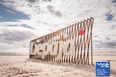
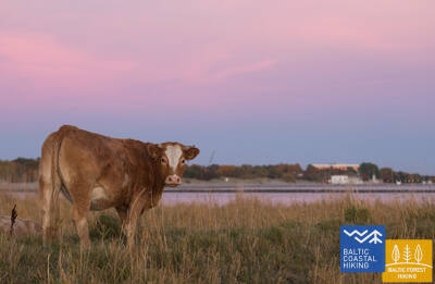
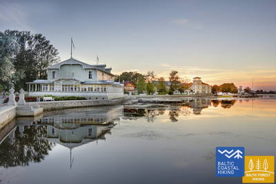
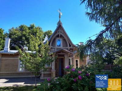
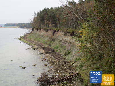
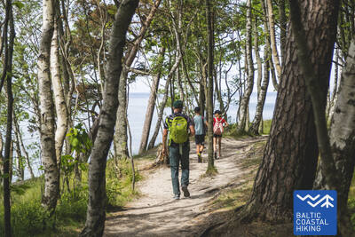
 Section 3. Bernāti - Liepāja - Karosta (The War Port).
The City Where The Wind Is Born
From Bernāti to Liepāja, the Baltic Coastal Hiking Route leads through a wide beach where initially the coast is formed by washed away shores, but as you approach Liepāja high foredunes covered in sand ryegrass and marram grass appear in sight. Later the trail winds through the old town of Liepāja and “New Liepāja”, crossing the Naval Port Canal to reach the Naval Port: a complex of military and fortification buildings the visitation of which is likely to take a half day. You should certainly try the special dish of Liepāja called Liepājas menciņi made of smoked cod according to an ancient recipe from Southern Kurzeme.
It's worth dedicating at least 1-2 days to explore Liepāja's historic center, including the Trade Canal banks, Horse Island, the Liepāja forts, and Karosta. Karosta is one of Latvia's most impressive military heritage sites, featuring landmarks such as the Karosta Prison, Northern Forts, and the Oskars Kalpaks Bridge, which have witnessed various eras of power. The area is ideal for photoshoots, photography, filming, and exploration.
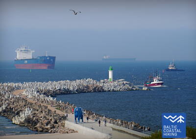
 Section 10. Ventspils - Staldzene.
Through Ventspils
The itinerary goes through Ventspils and its surrounding forests. The Baltic Coastal Hiking Route winds from the South Pier through the historic Ostgals and the Old Town, crosses the Venta River and continues through the Pārventa District via a pedestrian and cyclist path in the direction of Staldzene where it circles the Ventspils Port and then returns to the seacoast. It is worth taking one “day off” and get to know the most interesting places in the city, as well as visit the Seaside Open-Air Museum.
Ventspils historic center, its neighborhoods, and the coastline are rich in both cultural and industrial heritage, as well as military history. This includes coastal defense batteries, former missile storage bunkers, launch sites, and other significant sites. The area offers intriguing opportunities for urban hikes, exploration, and photo and video sessions.
Section 23. Bulduri - Riga City Center.
Through the Forests To Riga
The itinerary is an alternative way to get from Jūrmala to Riga by going through the forest. After passing the bridge across the Lielupe River, the Baltic Coastal Hiking Route snakes through Priedaine with its wooden buildings, goes along the right bank of the Lielupe River, then turns towards the Southern part of Bolderāja Dune and crosses Kleisti forest past Lāčupe Cemetery. Next, it goes along the historic roads of Pārdaugava on the West bank of the Daugava River, namely, Buļļu and Daugavgrīvas iela, through Dzegužkalns Hill, passing the Zunda Canal and Āgenskalns bay until reaching the Daugava River, which the route crosses via the Stone bridge and then stops at Town Hall Square.
An interesting section between Jūrmala and central Riga includes: Priedaine's historic buildings, Spilves Meadows and Kleisti Forest with Latvian Riflemen World War I battle sites, Pārdaugava's development, the former Iļģuciems industrial zone (19th-20th centuries) with Dzegužkalns, the Zunda Embankment, Ķīpsala's development and museums, and Āgenskalns Bay and the Daugava bridges as examples of industrial heritage.
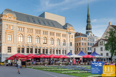
Section 24. Riga City Center - Vecāķi.
Riga Old Town – a UNESCO World Heritage site
Initially, the itinerary takes you on a small stroll around Riga City Center, Riga Old Town, leads along the City Canal through Kronvalds Park, via Alberta iela (Art Nouveau buildings) and further on via Miera iela through the Lielie kapi Cemetery, via Kokneses and Ostas prospekts through Mežaparks and then it reaches Jaunmīlgrāvis and crosses Mīlgrāvis . Then it meanders along Vecāķu prospekts up to Ziemeļblāzma and the banks of the Old Daugava River (Vecdaugava) separated by only a couple of kilometers from Vecāķi. After a two-day hike through Riga, the Baltic Coastal Hiking Route leads you out to the beach again.
Old Riga (a UNESCO World Heritage Site), the historic center of Riga with its churches, the Canal Embankment, the Freedom Monument, and Alberta Street (noted for Art Nouveau architecture). Also interesting are Riga's "green areas"—the Biķernieki and Šmerli forests.
Izeja uz Vecāķu pludmali

There is easy access to Vecāķi Beach from Selgas Street in Vecāķi. There is a parking lot, an access path to the sea, and a changing cabin.

Section 34. Uulu - Pärnu.
Along the Wetlands to Pärnu
First, the Baltic Coastal Hiking Route takes the old coastal roads surrounded by pine forests, but after passing Lottemaa Park it turns towards the sea and comes out at Reiu beach. Next, the hike continues across an overgrown beach (wide shoals when the winds create an outflow of water) and after a little less than 4 km you have to turn inland, cross a golf course and turn in the direction of Pärnu. Near the Raeküla district, it snakes along a small trail forming the border between the large coastal wetland and the forest. Having looped around the wetland for ~ 6 km, the Baltic Coastal Hiking Route emerges at Pärnu beach. Further on, the road goes through the western part of Pärnu Old Town, crosses the Pärnu River and the Sauga River and ends in the Vana-Pärnu district.
The areas around Pärnu, the coastline, the resort with modern SPA hotels and old wooden buildings, the city center, and the old town - a suitable place for urban hikes, photo, and video sessions.
Section 48. Rohuküla - Haapsalu - Uuemõisa.
The Most Popular Resort in Estonia - Haapsalu
A multifarious section of the Baltic Coastal Hiking Route. The first three kilometres of the itinerary go along the former Haapsalu – Rohuküla broad-gauge railway line, takes you on a stroll along Haapsalu Bay through Pullapää cape, crosses coastal forests, which contain health trails, and continues via coastal promenades and small streets around Haapsalu Town. After crossing a small wetland beyond the town, this section of the trail ends in the beautiful Uuemõisa Park.
The history of Haapsalu city can be explored across a wide timeline - starting with the medieval castle ruins, continuing with the streets of the historic Haapsalu resort and its wooden buildings, and concluding with modern architecture.
Section 55. Padise - Paldiski.
Paldiski: The Former Closed and Top Secret Town
Starting from Padise up to Karilepa, the Baltic Coastal Hiking Route winds through small country roads, while further on to Madise it goes along the side of the road. From the ancient seacoast of the Madise church hill, you will have magnificent views of Paldiski Bay and the Pakri Islands. From Madise to Paldiski, the itinerary continues along the side of the abovementioned road up to the South Harbour and, by going along it, the route reaches the railway station located in the southern part of Paldiski. During Soviet times, Paldiski was a closed town with a military port and a nearby nuclear submarine training base at the Pakri Peninsula that operated using a small nuclear reactor.
The city of Paldiski and its surroundings (industrial environment, cultural monuments from earlier centuries, railway), the remains of former fortification systems, and former military areas from the 20th century are suitable for urban hikes and photo-video sessions. During the Soviet era, the Pakri Peninsula was a closed military area.
Section 60. Tabasalu - Tallinna sadam.
Tallinn – A UNESCO World Heritage Site
Near Tabasalu, the Baltic Coastal Hiking Route crosses the boundary of Tallinn and goes through the Tiskre and Vismeistri districts to reach Kakumäe beach, where it takes you on a stroll around the wooded upper part of the Kakumäe Peninsula surrounded by cliffs. Here, you will have a vista of the Port of Tallinn across Kopli Bay. Opposite the Õismäe district, an excellent promenade goes along the seashore. After bypassing the Estonian Open-Air Museum, the Baltic Coastal Hiking Route winds along the coastal promenade up to Stroomi beach and after passing the Pelguranna district it takes pedestrian sidewalks to the Estonian Maritime Museum, where it leads you, via the coastal promenade, to the Port of Tallinn, marking the end of the Baltic Coastal Hiking Route. You have covered ~ 620 km in Estonia.
A very interesting section - both the surroundings of Tallinn city and the central part (Seaplane Harbour, Patarei Sea Fortress, promenades) and the historic center of Tallinn - a UNESCO heritage site, which are suitable for urban walks at any time of the year and photo-video sessions.
 Section 67. Klaipėda – Palanga.
Through the Seaside Regional Park
Following H. Manto Street, the Baltic Coastal Hiking Route leads out of the center of Klaipėda, traverses the Klaipėda Recreation Park, crosses a railway line by bridge and comes out onto the coast of the Baltic Sea in the southern part of Melnragė. The trail then winds through the dunes, for the protection of which wooden walkways have been installed, and continues on along a beautiful path through the coastal forest, following at a distance of about 10–20 m the pedestrian/cyclist lane through Antroji Melnragė to Giruliai. At Giruliai, it briefly comes out onto the beach, but from Kukuliškiai to the southern part of Karklė Village, the Baltic Coastal Hiking Route first passes along the incredibly beautiful coastline of the former Littorina Sea covered in primeval forest, and later, along a scenic bluff, created by the washing of waves; there are several viewing points along the way (including the Dutchman's Cap). From the Village of Karklė for the next 11 km to the Palanga Botanical Park, the Baltic Coastal Hiking Route leads across sandy and pebbly, occasionally rocky beaches. Through the coastal pathways in the western part of the Palanga Botanical Park, the trail leads over to Meilės avenue and then to the Palanga pedestrian bridge. Most of this section of the trail leads through the Seaside Regional Park.
The historic center of Klaipėda, with its various periods of military heritage in the city, the northern part of the Curonian Spit (Kuršių nerija) (Kopgalis), and the Giruliai area, is a suitable place for exploring various urban objects, sightseeing, photo, and video sessions.
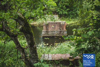
Section 73. Dreverna – Klaipėda.
Along King Wilhelm Canal to Klaipėda
From the Village of Dreverna, the Baltic Coastal Hiking Route follows the Priekulė Road (No. 2206) to cross the Dreverna River, the Klišupė River and the King Wilhelm Canal, after which it turns off to the left, and for the next 9 km it leads through a lush tree-lined lane along the eastern bank of the historical canal. Along the way there are various rest spots and tourist information stands explaining the diversity of the local natural environment. The trail reaches Kairių Street 4 km later, and the next section of the trail leads through an urban area. From Jūrininkų Prospektas to Baltijos Prospektas, the Baltic Coastal Hiking Route leads through city parks, crossing the footpaths of Reform Movement (Sąjūdžio), Reykjavík, Friendship (Draugystės) and other parks. Having crossed Baltijos Prospektas, the trail follows the pedestrian lanes of Taikos Prospektas, reaching Birža Bridge 3 km later.
The Wilhelm Canal, the suburbs of Klaipėda with its surroundings, and a walk through the city are suitable for enthusiasts of urban landscapes and industrial heritage.