


Baltic Forest Hiking - Kaunas

Kaunas and Kaunas district
Picturesque towns surrounded by greenery and interwar architecture at the confluence of two rivers
Pakuonis – Kaunas – Lampėdis – Kulautuva – Vilkija: 79 km, 5 days.
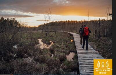
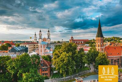
Kaunas, one of the most beautiful Lithuanian cities, is located at the confluence of the Nemunas and the Neris. It is Lithuania’s second largest city, the capital of the former Kovno Governorate of the Russian Empire (1842–1915) and the interim capital of Lithuania (1919–1940). Panemunės šilas is the largest park in Kaunas, with beaches on the bank of the Nemunas, bicycle lanes and footpaths. Lampėdis quarry (125 ha) used to be a gravel extraction site. Its banks serve as a popular recreational and bathing area for townspeople. Making a loop through the resort town of Kulautuva, a footpath and a bicycle lane stretches along the Nemunas as far as to Vilkija and offers beautiful views over the river. On the way to Vilkija, a diverse landscape with small settlements, castle-mounds and forests can be enjoyed.
 Section 62. Pakuonis – Vaišvydava.
Through the Kaunas Lagoon Regional Park
From Pakuonis town the Forest Trail continues along Kauno street (No. 1901) in the northwest and northern direction and after 7 km reaches Piliuona town. After Piliuona, it runs along Nemuno street and after about 1.6 km turns left in the direction of Dubravai. After crossing the forest massif, after about 2.4 km the Forest Trail leads to Dubravai village, winds along its main street and after 3 km (Klonio street, No. 1937) reaches Vaišvydava village, where the visitor centre of Kaunas Lagoon Regional Park is located.
Section 63. Vaišvydava – Kaunas.
Through Kaunas parks
From the Kaunas Lagoon Regional Park Visitor Centre, the Forest Trail leads through the Rokų forest and along the Miškininkų, Kelmyno, Muraškinės, Žarstos, Garšvės and Rokelių streets, circles the Kaunas suburbs, crosses the Marijampolė road (No. 139) and continues in the direction of Balčkalnio street to Panemunė district. At the stadium of Kaunas University of Technology Engineering Lyceum, it descends to Vaidoto street, then continues along the sidewalk to Baterijos highway, where it turns left. About a third of Kaunas city area is occupied by parks and other nature territories. The Forest Trail crosses the city through its greenest parts. About 2.5 km long the Forest Trail passes through the Panemunė pinewood, which has a dense network of trails, recreation areas and a beach. The Forest Trail crosses the Nemunas along the Three Virgin Bridge, leads through Gričiupis district, runs along Kaunas Zoo, crosses the vast Oak-Wood Park (Ąžuolynas) and leads through Vytauto Park behind the Lithuanian Sports University. Down the park stairs, the path descends to the beginning of the Avenue of Freedom (Laisvės Alėja) and continues to the destination of the section in Kaunas center.
IMPORTANT. There are no markings where itineraries are crossing the territory of Kaunas city.
Section 64. Kaunas – Lampėdžiai.
Through the historical centre of Kaunas
Kaunas is the second largest city in Lithuania. The 1621 m long Avenue of Freedom (Laisvės Alėja) stands out for its unique modernist architecture – its 1914–1940 buildings has received the European Heritage Label. Vilniaus street is the “gateway” to the medieval city of Kaunas, run by Hanseatic merchants. The Forest Trail runs along Avenue of Freedom (Laisvės Alėja), crosses the Old Town of Kaunas with churches, the Town Hall Square and historical buildings, and throws a circle along Confluence Park (Santakos parkas), where Lithuania's largest rivers, the Nemunas and the Neris, meet. After crossing the Neris river, the Forest Trail continues along the footpaths and bicycle paths to the 4 km distant former Lampėdis gravel quarry, which is flooded and now is a popular place for recreation and swimming.
IMPORTANT. There are no markings where itineraries are crossing the territory of Kaunas city.
Section 65. Lampėdžiai – Kulautuva.
Along the bank of the Nemunas
The first 2 km the Forest Trail winds along the northern shore of the Lampėdis quarry and leads to the highway in front of the cemetery. Continuing its journey along the sidewalk in the direction of Raudondvaris, the Forest Trail crosses the Nevėžis river. After 0.6 km, the Forest Trail turns left onto Pakalnės street and, in front of the confluence of the Nevėžis and Nemunas, continues along small paths on the right bank of the Nemunas. Old mounds can be seen on the banks of the Nemunas valley. Beyond Šilelis village, the Forest Trail continues along a pedestrian / bicycle path to the small-town of Kulautuva, in front of which it throws a circle along a small forest path. Then the trail moves along Pušyno and V. Augustausko street until it reaches the destination of this section.
IMPORTANT. There are no markings where itineraries are crossing the territory of Kaunas city.
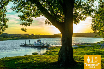
Section 66. Kulautuva – Vilkija.
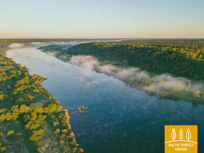
Along the meadows of the floodplains of Nemuna
Throughout this section, the Forest Trail leads along paths and small country gravel roads on the right bank of the Nemunas. Beautiful landscapes with views of the river, riverside meadows and small villages. The destination of the section – the Vilkija ferry can be seen from afar on the banks of the Nemunas. Opposite the ferry there is a centre of the small-town with a church. In the second half of the summer, the Nemunas meadows bloom in yellow and blue flowers. It is worth trying a round-trip ferry, because such a vehicle is preserved in only a few places in the Baltic States.