


Baltic Coastal Hiking trail - Canoeing

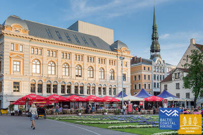
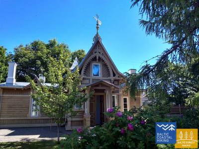
 24. päev. Riia kesklinn – Vecāķi.
Riia vanalinn – UNESCO maailmapärandi hulka arvatud paik
Ranniku matkarada teeb alguses väikese tiiru Riia kesklinnas – vanalinnas ja kanali ääres, jätkub läbi Kronvaldsi pargi, mööda juugendstiilis Alberti tänavat kuni Miera tänavani, liikudes edasi läbi suure kalmistu (Lielie kapi) ning piki Koknese ja Osta puiesteid. Läbides Mežaparksi linnaosa jõuab rada Jaunmīlgrāvisesse ja ületab Mīlgrāvise kanali. Edasi lookleb rada mööda Vecāķi puiesteed kuni Ziemeļblāzma kultuurikeskuseni ja Vecdaugava jõe kallasteni, millest mõne kilomeetri kaugusele jääb Vecāķi asula. Pärast kahepäevast teekonda läbi Riia linna jõuab matkarada tagasi randa.

Riia kanal ja Daugava – populaarne süsta- või kanuusõidu koht.
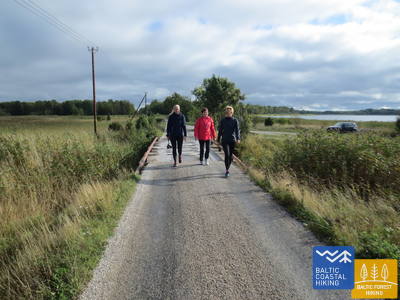
 41. päev. Pivarootsi - Virtsu.
Eesti saarte värav
Ranniku matkaraja Pivarootsi – Virtsu lõigul kulgeb rada umbes 3,7 km mööda kunagist Virtsu – Rapla kitsarööpmelise raudteetammi. Kirsiks tordil on Puhtulaiu poolsaar, mis kunagi oli saar, kuid on tänaseks maismaaga kokku kasvanud. Poolsaarel kasvab laialehine, huvitava taimestiku ja põlispuudega mets, kus on mitmeid mälestusmärke. Virtsu sadamast läheb praam Muhu saarele, mis on tammiga ühendatud Saaremaaga.
Virtsust saab teha meresüstamatkasid läbi mandrit Muhu saarega ühendava väina, aga ka külastada teisi väiksemaid saari, näiteks Kesselaidi.
47. päev. Tuuru - Rohuküla.
Teine värav Lääne-Eesti saarestikku
Ranniku matkaraja Tuuru – Rohuküla lõiku iseloomustab maastiku vaheldusrikkus – pisikesed külad vahelduvad põllu- ja karjamaadega, talumajapidamiste ning lubjakivikarjääridega. Rannikul liikumist takistavad märgalad ja eramaad. Rada jõuab mereni Kivikülas ja Puskus, kus avanevad vaated Väinamerele ja selle saartele.
Rohuküla sadamast saab sõita meresüstaga 9 km kaugusel asuvale Vormsi saarele, aga ka teistele väiksematele saartele. Samast sadamast pääseb parvlaevaga Eesti suuruselt teisele saarele Hiiumaale, mis pakub laialdasi aktiivse turismi võimalusi.
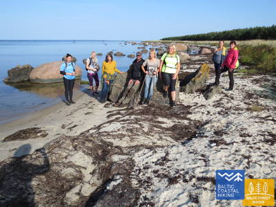
51. päev. Riguldi - Dirhami.
Meteoriidijälgedega paik
Ranniku matkaraja Riguldi – Dirhami lõigust enamus kulgeb mööda liivaranda. Randa võib olla uhutud vetikaid ja kohati on luited kaetud tiheda taimestikuga. Rooslepa küla lähedal võib meres silmata bretšasid ehk kivimeid, mis on moodustunud meteoriidiplahvatuse tagajärjel. Teekonna lõpus saab jalgu puhata kohvikus, mille terrassilt avaneb kena vaade merele ja sadamale.
Dirhami sadamast saab minna meresüstamatkale (teenuse ette broneerides ja kokku leppides) 8,7 km kaugusel asuvale Osmussaarele.
55. päev. Padise - Paldiski.
Paldiski – salapärane, kunagi suletud linn
Ranniku matkaraja Padise – Paldiski lõik kulgeb Padiselt Karilepani mööda pisemaid kruusateid, aga edasi Madiseni juba piki maanteed. Madise kabelimäelt, ammuselt merekaldalt, avaneb suurepärane vaade Paldiski lahele ja Pakri saartele. Madiselt Paldiskisse kulgeb teekond maanteepervel kuni Lõunasadamani, jõudes sadamaterritooriumi serva mööda Paldiski lõunaosas paiknevasse raudteejaama. Paldiski oli nõukogude ajal suletud linn, kus asusid sõjasadam ja Pakri poolsaarel tuumareaktoril töötav tuumaallveelaevade koolitusbaas.
Paldiskist saab minna meresüstamatkale Pakri saartele. Lisainfot vaata https://retked.ee/et/trips/sea-kayaking-trips/pakri-saared/
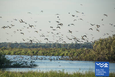
69. päev. Rusnė Island.
Rusnė Island — excellent location for wildlife observation
Balti ranniku matkatee saab alguse Rusnė külast Rusnė saarel. Rada viib läbi Neringose tänava ja K. Jukštaičio tänava Rusnė küla rannaäärsele kõnniteele, mis kulgeb mööda Pakalnė jõge – Nemunase delta üht suurimat jaotikku. Läänemere ranniku matkatee viib edasi läbi väikese Rusnė sadama, uidates läbi Rusnė poldritammide kuni Pakalnė külani, pakkudes imelisi vaateid saare värvilisele arhitektuurile ja Pakalnė vete üle ulatuvatele pajupuudele. Peale Pakalnė küla kuni Uostadvarise tuletornini kulgeb marsruut valdavalt Rusnė poldritammidele, mis ümbritsevad ja põimivad madalat saart (saarel on koht, mis asub allpool merepinda), et kaitsta seda üleujutuste eest. Tuletornist Rusnė külani kulgeb Balti ranniku matkatee mööda kõvakattega teed (välja arvatud Uostadvarise külas, kus rada kulgeb Atmata jõe kaldal asuval poldritammil). Rusnė külas kulgeb rada mööda Kuršmarių tänavat ja Taikose tänavat tagasi alguspunkti. Rusnė saar asub Nemunase delta regionaalpargis. Poldritammid sobivad suurepäraselt madalate tasandike metsloomade vaatlemiseks – siin võib näha metskitsi, põtru ja linde kevad- ja sügisrändel.
Nemunase delta ja Minija on põnevad kohad kanuumatkadeks.