Baltic Coastal Hiking trail - Canoeing
 24. Etappe. Stadtzentrum Rīga - Vecāķi.
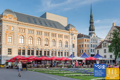
Die Altstadt - Teil des UNESCO-Weltkulturerbe
Der Routenabschnitt verläuft durch das Stadtzentrum von Rīga - die Altstadt, den Stadtkanal entlang, durch den Kronvalda-Park, die Alberta-Straße (Jugendstilbauten) und dann weiter durch die Miera-Straße über den Großen Friedhof, die Alleen Kokneses prospekts und Ostas prospekts und den Mežaparks (Kaiserwald) hindurch erreicht man den Stadtteil Jaunmīlgrāvis und passiert den Stadtteil Mīlgrāvis. Über die Allee Vecāķu prospekts führt der Weg weiter bis nach Ziemeļblāzma und zum Ufer der Vecdaugava, wovon Vecāķi nur wenige Kilometer entfernt ist. Nach einer zweitägigen Wanderung durch die Stadt Rīga führt der Pfad Jūrtaka wieder zum Strand zurück.
Rigaer Kanal und Daugava – ein beliebter Ort zum Kajak- oder Kanufahren.
 41. Etappe. Pivarootsi - Virtsu.
Das Tor zu den estnischen Inseln
Auf dieser Strecke verläuft ein ~ 3,7 km langer Wegabschnitt der ehemaligen Schmalspurbahnlinie Virtsu-Rapla entlang. Der interessanteste Ort dieser Strecke ist die Halbinsel-Insel Puhtulaiu, die heutzutage mit dem Festland zusammengewachsen ist. Die Insel ist von einem breitblättrigen Laubwald bedeckt, unter dessen Kronen sich interessante Pflanzen- und Pilzarten, Jahrhundertbäume und Gedenkstätte bedeutender Menschen verbergen. Zwischen dem Hafen von Virtsu und der Insel Muhu verkehrt die Fähre. Muhu ist mit der Insel Saarema durch einen Damm verbunden.
Von Virtsu aus können Sie Kajaktouren durch die Meerenge unternehmen, die das Festland mit der Insel Muhu verbindet, und auch andere kleinere Inseln wie Kesselaid besuchen.
 47. Etappe. Tuuru - Rohuküla.
Das zweite Tor zum Archipel der Moonsund-Inseln
Auf dieser Stecke des Baltischen Küstenwanderweges ist die Landschaft sehr abwechslungsreich. Kleine Dörfer werden von bearbeiteten Feldern, Weiden, Einzelhöfen und Steinbrüchen zur Kalksteingewinnung abgelöst. Das Wandern der Meeresküste entlang wird durch Feuchtgebiete und Privatgrundstücke eingeschränkt. Aus diesem Grund führt der Pfad lediglich in den Dörfern Kiviküla und Pusku zum Meer, wo sich ein Blick auf die Väinameri-Meeresenge und die zahlreichen Inseln sowie den Rohuküla-Hafen eröffnet.
Vom Hafen Rohuküla aus können Sie mit dem Seekajak zur 9 km entfernten Insel Vormsi sowie zu anderen kleineren Inseln fahren. Vom selben Hafen aus können Sie mit der Fähre nach Hiiumaa, der zweitgrößten Insel Estlands, fahren, die umfangreiche Möglichkeiten für Aktivtourismus bietet.
 51. Etappe. Riguldi - Dirhami.
Ein Ort mit Meteoritenspuren
Mit Ausnahme der ersten drei Kilometer verläuft der Routenabschnitt der Meeresküste entlang. Vorwiegend erstreckt sich hier ein sandiger Strand mit herrlichen Vordünen, Graudünen und Feldsteinen im Meereswasser. Am Strand können zusammengetriebene Wasserpflanzen liegen; stellenweise ist er mit dichter Vegetation bewachsen. Gegenüber dem Dorf Rooslepa, aber auch im Meer und an der Küste kommen verwitterte Steine bzw. Brekzien zum Vorschein, die infolge einer alten Meteoritenexplosion zusammengeschmolzen und verwittert sind. Zum Abschluss kann man eine Kneipe besuchen, von deren Terrasse aus sich ein schöner Blick auf die Meeres - und Hafenlandschaft offenbart.
Vom Hafen Dirhami aus können Sie (nach vorheriger Buchung und Vereinbarung) eine Kajaktour zur 8,7 km entfernten Insel Osmussaar unternehmen.
 55. Etappe. Padise - Paldiski.
Paldiski – die einst geschlossene und verbotene Stadt
Von Padise bis Karilepa windet sich der Baltische Küstenwanderweg auf kleinen Landwegen. Danach verläuft er bis Madise der Landstraße entlang. Vom Kirchberg des Dorfes Madise aus, der an der Altküste liegt, eröffnet sich ein hervorragender Blick auf die Paldiski-Bucht und die Pakri-Inseln. Von Madise bis Paldiski folgt man dem Pfad entlang der vorher genannten Landstraße bis zum Südhafen der Stadt. Am Rand des Hafens entlang erreicht man den im südlichen Teil der Stadt Paldiski gelegenen Bahnhof. Während der Sowjetzeit war Paldiski eine geschlossene Stadt mit einem Militärhafen und einem Trainingszentrum für atomgetriebene U-Boote auf der Pakri-Halbinsel. Dort wurde mit ein kleiner Kernreaktor betrieben.
Von Paldiski aus können Sie eine Seekajaktour zu den Pakri-Inseln unternehmen. Weitere Informationen finden Sie unter https://retked.ee/en/trips/sea-kayaking-trips/pakri-islands/
 69. Etappe. Insel von Rusnė (dt. Ruß).
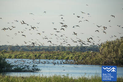
Insel von Rusnė ist ein großartiger Ort zum Beobachten der Wildtiere
Hier in der Stadt Rusnė, auf der Insel Rusnė beginnt der Meeresweg (lt. Jūrų takas). Er führt durch die Straßen Neringos und K. Jukštaičio zur Küstenpromenade des Flüsschens Rusnė (dt. Ruß) - die sich entlang des Flusses Pakalnė, einem der Zweige des Nemunas-Deltas, erstreckt. Danach schlängelt der Meeresweg über den Hafen von Rusnė, durch die Böschungen der Polder - bis zum Dorf Pakalnė und schenkt uns schöne Ausblicke auf die farbenfrohe Bebauung der Insel und die Weiden, die über das Wasser der Pakalne lauern. Außerhalb des Dorfes Pakalnė führt der Weg weiter durch die Polder zu der niedrigsten Stelle Litauens (Rusnė ist ein Ort unter dem Meeresspiegel). Die Böschungen der Polder schützen diesen Ort vor Überschwemmungen. Anschließend präsentiert sich hocherhaben der Leuchtturm von Uostadvaris. Von dem Leuchtturm aus, bis zur Stadt Rusnė (mit Ausnahme von Uostadvaris selbst), wo der Weg am Ufer des Atmata-Flusspolders verläuft, führt der Meeresweg an dem Rand einer Asphaltstraße. In der Stadt Rusnė, den Ausgangspunkt der Route, ist über die Straße, Kuršmarių und Taikos zu erreichen. Die Insel Rusnė liegt im Regionalpark von Nemunas-Delta. Die Böschungen der Polder sind wunderbare Plätze um die Wildtiere, Hirsche, Elche und Vögel während der Frühjahrs- und Herbstwanderungen auf der Ebenen der Insel zu beobachten.
Das Nemunas-Delta und Minija sind interessante Orte für Kanufahrten.


