


Baltic Forest Hiking - City hikes


 1. päev. Riia vanalinn ‒ Baltezers.
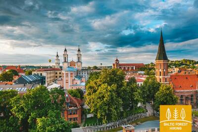
Läbi Riia ‒ UNESCO maailmapärandi meistriteos
Metsa matkaraja alguspunkt Lätis asub Riia vanalinnas, Raekoja platsil. Rada kulgeb piki Kaļķu tänavat, mööda Vabadussambast, läbi Vērmane aia ja jätkub Tērbata (Tartu) maanteel, ületab Zemitāni raudteejaama jalakäijate silla ning suundub Biķernieki ja Šmerlise metsadesse. Tee läbib Läti etnograafilise vabaõhumuuseumi ja kulgeb mööda kergliiklusteed Baltezersi külani.

Riia vanalinn (UNESCO maailmapärandi nimistus), Riia ajalooline keskus oma kirikute, kanalipiirkonna, vabadussamba ja Alberta tänava (juugendstiilis) abil. Huvitavad on ka Riia rohelised alad, näiteks Biķernieki ja Šmerlise metsad
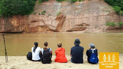
 6. päev. Līgatne‒Cēsis.
Piki vana Cēsise teed läbi Amata jõe oru
Metsa matkaraja üks kõige maalilisemaid lõike kulgeb läbi Līgatne paberivabriku ajaloolise töölisküla, möödub Spriņģi paljandist, tiirutab mööda Skaļupe matkarada ja mütoloogilist rada, põikab läbi ühest Nõukogude aja kõige salajasemast kohast – suurest maa-alusest punkrist ‒ siinpool raudset eesriiet ning suundub edasi Roči looduskaitsealale, ületab Amata jõe (selles lõigus on Amata kõige ilusam ja paljandirohkem) ning jõuab lõpuks välja Zvārte paljandini. Järgmiseks kulgeb metsa matkarada Amata oru kõrgetel kallastel ning suundub mööda ajaloolist Cēsise–Riia “maanteed” (praegu väike külavahetee, mille ääres on vanad teetähised) Rakšisse, tõuseb üles Vāļukalni mägedele ja Ozolkalnsi. Gauja jõe kaldaid pidi edasi suundudes kohtub metsa matkarada Cīrulīši loodusradadega. Päeva teekond lõpeb Gauja tänaval, kuid matkajad võivad kõndida rada mööda edasi Cēsisesse (2,8 km), veeta seal öö ning jätkata sealt järgmisel päeval teekonda.
Cēsise ajalooline keskus, kus asuvad Liivi ordulinnuse varemed, Uuslinnus, Jaani luteri kirik, selle väikesed tänavad, Cēsise muuseum ning paljud kultuuri- ja ajaloomälestised, on ideaalne koht kohalikeks matkadeks. See pakub võimalust tutvuda kohalike traditsioonide, erinevate iga-aastaste sündmuste, kulinaarse pärandi ja muuga.
39. päev. Mahu‒Kunda.
Tutvudes Kunda tööstuspärandiga
Mahult Letipeani kulgeb metsa matkarada väikestel merelähedastel teedel ja väiksemas lõigus ka mööda rannikut. Letipea neeme lähedal on tihe kadakavõsa. Kel käimata, tasub ette võtta kokku 1,5-kilomeetrine retk Ehalkivi juurde. Simunamäelt 3 km edasi liikudes kulgeb rada Põhja-Eesti paekalda jalamil, mis on kaetud vana loodusmetsaga. Mereni on siit umbes kilomeeter. Lontova mõisa ümbruses on infotahvlid Kunda ajalooga. Kundas, eriti Kunda jõe ääres on mitmeid põnevaid vaatamisväärsusi, mis on seotud linnas asuva tsemenditehasega.
Selle metsaraja lõigu lõpus on Kunda – linn, millel on tsemenditootmisega seotud rikkalik tööstusajalugu ja esimene hüdroelektrijaam Balti riikides. See on ideaalne koht linnas jalutamiseks ja fotosessioonideks.
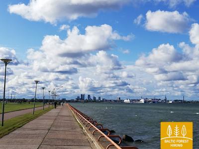
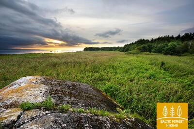
50. päev. Püünsi‒Tallinn.
Tallinna vanalinna pilgupüüdjad
Metsa matkarada kulgeb piki Tallinna lahe rannikut ning alates Püünsist avanevad kaunid vaated Tallinna tornidele, pilvelõhkujatele ja sadamale. Enne Piritat pöörab rada männimetsa, seejärel aga kahekilomeetrilisele Pirita liivarannale. Pärast Piritat kulgeb rada kuni Tallinna sadamani kenal rannaäärsel promenaadil, kust avaneb vaade linna kultuurilistele ja ajaloolistele vaatamisväärsustele ning merele ja sadamale. Metsa matkaraja lõpp-punkt asubki vanalinna kõrval asuvas Tallinna sadamas. Võta päev või paar, et põhjalikumalt tutvuda Tallinna arvukate vaatamisväärsustega.
Tallinna vanalinn, kesklinn, äärelinnad ja rannajoon sobivad ideaalselt linnamatkadeks igal aastaajal, pildistamiseks ning ajaloo, sealhulgas sadama ja militaarpärandiga tutvumiseks.
63. päev. Vaišvydava – Kaunas.
Läbi Kaunase parkide
Kaunase veehoidla regionaalpargi külastuskeskusest viib Metsa matkarada läbi Rokų metsa ja piki Miškininkų, Kelmyno, Muraškinėse, Žarstose, Garšvėse ja Rokelių tänavaid Kaunase kesklinna suunas. Veidi aega tiirutab rada Kaunase eeslinnades, ületab Marijampolė maantee (nr 139) suundub Balčkalnio tänava kaudu Panemunė linnaosasse. Kaunase Tehnikaülikooli staadioni juurest laskub rada Vaidoto tänavale, jätkab teekonda Baterijose maantee ääres oleval kõnniteel, kuni keerab vasakule. Umbes kolmandik Kaunase linna pindalast on kaetud parkide ja teiste looduslike aladega. Metsa matkarada kulgeb läbi linna kõige rohelisemate alade. Umbes 2,5 km pikkuselt lookleb rada Panemunė männikus, kus on arvukalt teeradu, puhkealasid ja isegi supelrand. Nüüd ületab Metsa matkarada Kolme Neitsi silla kaudu Nemunase jõe, kulgeb läbi Gričiupise linnaosa, mööda Kaunase loomaaiast, läbib uhke Ąžuolynase tammiku ning jõuab Leedu Spordiülikooli taha asuvasse Vytauto parki. Pargist laskub rada mööda treppi Vabaduse puiesteele (Laisvės Alėja) ning suundub kindlalt Kaunase kesklinna.
TÄHTIS. Kaunase linna läbivatel lõikudel märgistus puudub.
Huvitav jalutuskäik kulgeb läbi Kaunase eeslinnade, mikrorajoonide, metsaparkide ja parkide, ületades Nemunase jõe.
64. päev. Kaunas – Lampėdžiai.
Läbi Kaunase ajaloolise kesklinna
Kaunas on Leedu suuruselt teine linn. 1621 meetri pikkune Vabaduse puiestee (Laisvės Alėja) paistab silma omapärase modernistliku arhitektuuri poolest: siinsed 1914.–1940. aastail ehitatud hooned on pälvinud Euroopa Pärandi märgi. Vilniuse tänav on „värav“ keskaegsesse Kaunasesse, mida juhtisid Hansa Liidu kaupmehed. Metsa matkaraja äärde jäävad Kaunase vanalinna kirikud, Raekoja plats ja arvukad ajaloolised hooned. Rada teeb looke Santakose pargis, kus kohtuvad Leedu kaks suurimat jõge, Nemunas ja Neris. Matkarada ületab Nerise jõe ning suundub kergliiklusteid pidi 4 km kaugusel asuva Lampėdise kruusakarjääri juurde. Karjääri on rajatud tehisjärv ning see on kohalike seas armastatud puhke- ja supluskoht.
TÄHTIS. Kaunase linna läbivatel lõikudel märgistus puudub.
Linna ajalooline keskus, vanalinn ja Nemunase kaldad koos promenaadidega sobivad lühemateks või pikemateks linnajalutuskäikudeks, sh öisel ajal, samuti foto- ja videosessioonideks. Lõigu lõpus asuvad endised kruusakarjäärid, mis on muudetud puhkealaks.
92. päev. Snēpele – Kuldīga.
Kuldīga – Kuramaa võluvaim keskaegne linn
Snēpele peatänavalt suundub Metsa matkarada teele nr V1294 ja 300 meetri pärast, Ķepšu järve kohal, keerab rada paremale, väiksele külateele. Tee viib Slipiņciemsi ning ületab seejärel tammi kaudu Sprincupe jõe. Siis võtab rada suuna Pelči poole. Pelči küla lähedal lookleb Metsa matkarada Pelči tammitiikide kallastel, viib Kuldīga–Pelči teele (V1293) ja sealt edasi Kuldīga aianduspiirkondadesse, mis kannavad nimesid “Kurzemīte” ja “Rumba”, kuni jõuab Venta jõe kallastele ja Kuldīga ringteele. Järgmised 2,4 km, kuni vana kivisillani, mööduvad ilusal Venta jõe äärsel kallasrajal, kus väiksed puust sillakesed ja purded viivad üle ojade ja niiskemate kohtade.
Kuldīga ajalooline keskus (UNESCO) oma kirikute, elu- ja taluhoonete, arhitektuursete elementide (nagu valgusaknad), Alekšupite jõe kallaste ja ainulaadse pakkumisega kahlata läbi väikese jõe, mis voolab läbi kesklinna. kummikutega hooned, vana tellissild, Venta juga jpm.
 102. päev. Bulduri – Riia kesklinn.
Läbi metsade Riia poole
Ranniku matkaraja lõik kulgeb Jūrmalast läbi metsaste alade Riia suunas. Pärast Lielupe jõe silda lookleb rada läbi puithoonestusega Priedaine linnaosa, piki Lielupe jõe paremkallast ja keerab Bolderāja luite lõunaosa suunas. Põigates läbi Kleistu metsa ja kulgedes paralleelselt Lāčupe kalmistuga jätkub matkarada ajaloolises Pārdaugava linnaosas – mööda Buļļi ja Daugavgrīva tänavaid ning läbides Dzegužkalnsi. Möödudes Zunda kanalist ja Āgenskalnsi lahest jõuab matkaja Daugava jõeni, ületab vana kivisilla ja on matkapäeva lõpuks jõudnud Riia raekoja platsile.
Huvitav lõik Jūrmala ja Riia keskosa vahel: Priedaine ajaloolised hooned, Spilve heinamaad ja Kleiste mets I maailmasõja aegsete läti laskurvõitluste paikadega, Pārdaugava piirkond, endine Iļģuciemsi tööstustsoon (19. 20. sajand), kus Dzegužkalns, Zunda rannapiirkond, Ķīpsala hooned ja muuseumid, Āgenskalnsi laht ning Daugava ületavad sillad on tööstuspärandi objektid.