


Mežtaka - Cauri pilsētai


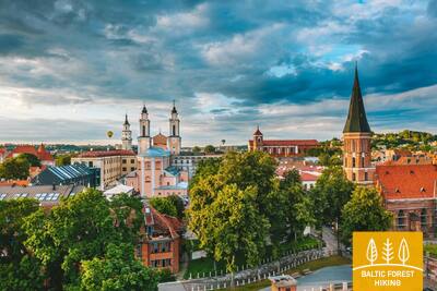
 1. posms. Vecrīga - Baltezers.
Cauri Rīgai – UNESCO Pasaules mantojuma vietai
Latvijā Mežtakas sākums atrodams Vecrīgas sirdī – Rātslaukumā. Maršruts ved pa Kaļķu ielu, garām Brīvības piemineklim, cauri Vērmanes dārzam un pa vēsturisko Tērbatas ielu. Tālāk tas izmet loku pa gājēju tiltu pāri Zemitānu dzelzceļa stacijai un turpinās pa Biķernieku un Šmerļa mežiem. Mežtaka vijas cauri Juglai, gar Latvijas Etnogrāfisko brīvdabas muzeju un pa gājēju un velosipēdistu celiņiem aizved līdz Baltezeram.
Vecrīga (UNESCO pasaules mantojuma objekts), Rīgas vēsturiskais centrs ar baznīcām, Kanālmalu, Brīvības pieminekli, Alberta ielu (Jūgendstils). Interesantas ir Rīgas "zaļās zonas" - Biķernieku un Šmerļa mežs.
 6. posms. Līgatne - Cēsis.
Pa veco Cēsu ceļu cauri Amatas ielejai
Viens no ainaviski skaistākajiem Mežtakas posmiem ved cauri vēsturiskajam Līgatnes papīrfabrikas ciematam, gar Spriņģu iezi izlīkumo pa Skaļupes takām un Mitoloģisko taku, iegriežoties vienā no Dzelzs priekškara slepenākajiem objektiem – Padomju bunkurā, tad turpinās pa ceļu gar Roču rezervātu, šķērso Amatu, pa kuras ģeoloģisko taku (skaistākais un klinšainākais Amatas posms) nonāk līdz Zvārtes iezim. Tālāk Mežtaka uzskrien Amatas ielejas augstajā krastā un pa vēsturisko Cēsu–Rīgas „lielceļu” (tagad – mazs lauku un meža ceļš ar vecajiem ceļa stabiem) aiziet līdz Rakšiem, atkal paceļas Vāļukalnos un no Ozolkalna gar Gaujas krastu izlīkumo Cīrulīšu dabas takās, kas bagātas ar smilšakmens klintīm un avotiem. Pie Gaujas ielas tas beidzas, taču ceļinieki pa šo ielu var aiziet līdz 2,8 km attālajai Cēsu vecpilsētai, vēl vienu dienu pavadīt Cēsīs un tad turpināt maršrutu.
Cēsu vēsturiskais centrs ar Livonijas ordeņa pilsdrupām, Jauno pili, Sv. Jāņa luterāņu baznīcu, mazajām ieliņām, Cēsu muzeju un daudziem kultūras un vēstures pieminekļiem ir piemērota vide lokāliem pārgājieniem, iepazīstot arī vietējās tradīcijas, dažādus ikgadējos notikumus, kulināro mantojumu u.c.
39. posms. Mahu - Kunda.
Kundas industriālo mantojumu pieredzot
Pie Mahu Mežtaka iet pa maziem piekrastes ceļiem tuvu jūrai. Ir vērts izmest 2 km garu līkumu (turp un atpakaļ) līdz Ehalkivi dižakmenim. No Simunamē (Simunamäe) 3 kilometru garumā Mežtaka ved pa ceļu Ziemeļigaunijas glinta piekājē, ko klāj primārais mežs. Jūras krasts šeit atrodas aptuveni kilometra attālumā. Lontovas muižas apkaimē izvietotas informatīvas plāksnes par Kundas vēsturi. Savukārt, Kundas upes krastos un pilsētā ieteicams iepazīt objektus, kas saistīti ar pilsētas cementa ražotnes vēsturisko attīstību.
Mežtakas posma finišā atrodas Kunda - pilsēta ar senu industriālo vēsturi, kas saistīta ar cementa ieguvi un Baltijas valstīs pirmo hidroelektrostaciju. PIemērota vieta pilsētas pastaigām ar fotosesijām.
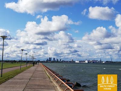
50. posms. Pūnsi (Püünsi) – Tallina.
Skaistākie skati uz Tallinas vecpilsētu
Mežtaka iet gar Tallinas līča krastu, kur jau no Pūnsi paveras skaisti skati uz vecpilsētas torņiem, ostu un pilsētas augstceltnēm. Pirms Piritas (Pirita) Mežtaka izlokās pa skaistu priežu mežu un tālāk ved gar jūras krastu pa 2 km garu smilšainu pludmali. Aiz Piritas līdz pat Tallinas ostai Mežtaka aizved pa skaisto pilsētas krasta promenādi, no kuras redzami nozīmīgi pilsētas kultūras un vēstures objekti un baudāmi jūras un ostas skati. Mežtakas finišs atrodas Tallinas ostā, kurai blakus atrodas Tallinas vecpilsēta. Tās apskatei vēlams atlicināt vismaz vienu vai divas atsevišķas dienas.
Tallinas vecpilsēta, centrs un piepilsētas, kā arī piekraste ir piemērota vieta urbāniem pārgājieniem visos gadalaikos, fotosesijām un vēstures (t.sk. - ostas, militārā mantojuma) izziņai.
63. posms. Vaišvydava – Kaunas.
Cauri Kaunas parkiem
No Kauņas jūras reģionālā parka apmeklētāju centra Mežtaka ved cauri Rokai mežam un pa Miškininkų, Kelmyno, Muraškinės, Žarstos, Garšvės un Rokelių ielām apmet loku Kauņas priekšpilsētai, šķērso Marijampolė ceļu (Nr. 139) un tālāk dodas Balčkalnio ielas virzienā uz Panemunes rajonu. Pie Kauņas Tehniskās universitātes inženierijas vidusskolas stadiona tā nolaižas līdz Vaidoto ielai, pa ietvi tālāk virzās līdz Baterijos šosejai, kur pagriežas pa kreisi. Apmēram trešdaļu no Kauņas pilsētas platības aizņem parki un citas dabas teritorijas. Mežtaka pilsētu šķērso cauri tās zaļākajām daļām. Aptuveni 2,5 km garumā Mežtaka ved cauri Panemunes silam, kurā ir blīvs taku tīkls, atpūtas vietas un pludmale. Mežtaka pa Trīs jaunavu tiltu šķērso Nemunas upi, tālāk ved cauri Gričiupis dzīvojamam rajonam, virzās gar Kauņas ZOO, šķērso plašo Ozolu parku un aiz Lietuvas Sporta universitātes izved cauri Vītauta parkam. Pa parka kāpnēm tā nolaižas līdz Laisvės alejas sākumam un turpinās līdz posma galamērķim Kauņas centrā.
SVARĪGS. Kauņas pilsētu šķērsojošajos posmos marķējuma nav.
Interesants būs gājiens pa Kauņas priekšpilsētas apkaimēm, mikrorajoniem, mežparkiem un parkiem, šķērsojot Nemunas upi.
64. posms. Kaunas – Lampėdis.
Cauri Kaunas vēsturiskajam centram
Kauņa ir otrā lielākā Lietuvas pilsēta. 1621 m garajā Laisvės jeb Brīvības alejā redzama izcila modernisma arhitektūra – 1914.–1940. g. būvētās ēkas ir Eiropas kultūras mantojums. Vilniaus iela ir “vārti” uz Kaunas viduslaiku pilsētu, kurā saimniekoja Hanzas tirgotāji. Mežtaka virzās pa Laisvės ielu, šķērso Kaunas vecpilsētu ar dievnamiem, Rātslaukumu un vēsturiskajām ēkām un izmet loku pa Sateces parku, kur ir Lietuvas lielākās upes Nemunas un Neris upes satekas vieta. Šķērsojusi Neris upi, Mežtaka pa gājēju celiņiem un veloceliņu ietvēm turpina gaitu līdz 4 km attālajam bijušajam Lampēdžu grants karjeram, kas ir appludināts un šobrīd – iecienīta iedzīvotāju atpūtas vieta un peldvieta.
SVARĪGS. Kauņas pilsētu šķērsojošajos posmos marķējuma nav.
Pilsētas vēsturiskais centrs, vecpilsēta un Nemunas krasti ar promenādēm ir piemērota vieta īsiem vai garākiem urbāniem gājieniem, t.sk. diennakts tumšajā laikā, foto un video sesijām. Posma nobeigumā ir bijušie grants karjeri, kur izveidota rekreatīvā zona.
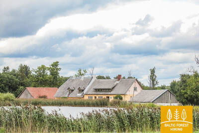
92. posms. Snēpele – Kuldīga.
Uz Kuldīgu – šarmantāko Kurzemes viduslaiku pilsētu
Pa Snēpeles galveno ielu Mežtaka izved uz ceļa V1294 un jau pēc 0,3 km iepretī Ķepšu ezeram nogriežas pa labi uz neliela lauku ceļa. Pa šo ceļu Mežtaka aizlīkumo līdz Slipiņciemam, pirms tā pa dambi šķērsojot Sprincupi, uz kuras izveidots dīķis. Tālāk Mežtaka dodas Pelču virzienā. Pelču apkaimē taka izlokās gar Dambu dīķiem, izved uz Kuldīgas–Pelču ceļa (V1293) un tālāk stiepjas cauri Kuldīgas dārziņu rajoniem – Kurzemītei un Rumbai, līdz sasniedz Ventas krastu un Kuldīgas apvedceļu. No tā līdz pat Senajam ķieģeļu tiltam Mežtaka 2,4 km garumā ved pa skaistu Ventas krasta taku, kur mitrākās vietās un pāri strautiem ir koka tiltiņi un laipas.
Kuldīgas vēsturiskais centrs (UNESCO) ar baznīcām, saimniecības un dzīvojamām ēkām, arhitektūras elementiem (gaismas lodziņi), Alekšupītes krasti un īpašs piedāvājums ar gumijas zābakiem izbrist pa mazo upīti, kas šķērso pilsētas centru starp ēkām, vecais ķieģeļu tilts, Ventas rumba u.c.

 102. posms. Bulduri - Rīgas centrs.
Cauri mežiem uz Rīgu!
Maršruts ir alternatīvs veids, kā no Jūrmalas nokļūt līdz Rīgai, ejot pa mežu. Aiz Lielupes tilta Jūrtaka izlīkumo cauri Priedainei ar skatiem uz tās koka apbūvi, iet līdztekus Lielupes labajam krastam, tad nogriežas gar Bolderājas kāpas dienviddaļu un šķērso Kleistu mežu, virzoties gar Lāčupes kapiem. Tālāk pa vēsturiskajiem Pārdaugavas ceļiem – Buļļu un Daugavgrīvas ielām cauri Dzegužkalnam, garām Zunda kanālam un Āgenskalna līcim nonāk līdz Daugavai, kur pa Akmens tiltu šķērso Daugavu un apstājas Rīgas Rātslaukumā.
Interesants posms starp Jūrmalu un Rīgas centrālo daļu: Priedaines vēsturiskā apbūve, Spilves pļavas un Kleistu mežs ar latviešu strēlnieku 1. Pasaules kara cīņu vietām, Pārdaugavas apbūve, bijusī Iļģuciema industriālā zona (19.-20.gs.) ar Dzegužkalnu, Zunda krastmala, Ķīpsalas apbūve un muzeji, Āgenskalna līcis un tilti pār Daugavu kā industriālā mantojuma objekti.