


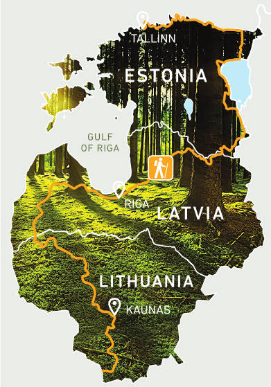
The Forest Trail is a long distance hiking route, part of E11, in the Baltic States that leads through the most forested lands, regional, nature and national parks of Lithuania, Latvia and Estonia. The route starts from the Polish - Lithuanian border near the town of Lazdijai, leads through Latvia, turning into Riga, and finishes in Tallinn, Estonia.
Name in Lithuania: Miško takas
Name in Latvia: Mežtaka
Name in Estonia: Metsa matkarada
Length: 2141 km, duration: 102-114 days
- in Lithuania – 747 km, 36-38 days
- in Latvia – 674 km, 31-38 days
- in Estonia – 720 km, 35-38 days
The route is divided into ~ 20 km long one-day or two-day sections with accommodation and transport options.
Road surface: asphalt road, gravel road, dirt road, trail, sidewalks, wooden path, sandy, pebble and rocky beaches. More detailed description see here.
Highest points and valleys: Nemunas Valley and Samogitian (Žemaitija) Highlands in Lithuania, Rietumkursa upland, ancient valley of Abava and Gauja Rivers, Veclaicene upland in the northern Latvia, Suur Munamägi - the highest peak of the Baltic States (318 m above sea level), Piusa ancient valley and northern coast in Estonia.
Highlights:
In Lithuania: Dzūkija and Žemaitija National Parks, Nemunas Loop Regional Park, Kaunas.
In Latvia: Kuldiga, Abava River Valley Nature Park, Kemeri National Park, Gauja National Park, Veclaicene protected landscape area, Riga Old Town.
In Estonia - Lahemaa National Park, Alutaguse National Park, Suur Munamägi, Lake Peipus - the fourth largest lake in Europe, Tallinn Old Town.


The contents of this web page are the sole responsibility of the project partners and can under no circumstances be regarded as reflecting the position of the European Union.