


Baltic Coastal Hiking trail - Easy hike

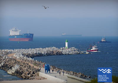
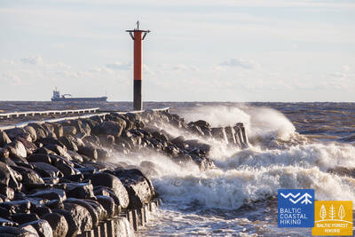
 Section 10. Ventspils - Staldzene.
Through Ventspils
The itinerary goes through Ventspils and its surrounding forests. The Baltic Coastal Hiking Route winds from the South Pier through the historic Ostgals and the Old Town, crosses the Venta River and continues through the Pārventa District via a pedestrian and cyclist path in the direction of Staldzene where it circles the Ventspils Port and then returns to the seacoast. It is worth taking one “day off” and get to know the most interesting places in the city, as well as visit the Seaside Open-Air Museum.
Places suitable for short walks and hikes include Seaside Park, the Seaside Open-Air Museum, the Southern Mole, Ventspils Beach, and the Old Town.
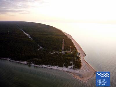
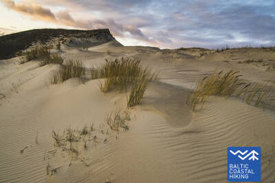
Section 15. Saunags village – Kolka.
The Heart Of Europe: Cape Kolka
The Baltic Coastal Hiking Route winds through small country and forest roads from Saunags village to Vaide village where it returns to the seacoast again. Wide sandy beaches stretch up to Cape Kolka turning into low sparse foredunes; wooded seaside dunes continue behind them. For around 2 km, there are washed away dunes followed by the Dumbrkalni Hills. Cape Kolka, the point where the Great Sea meets the Little Sea, is one of the most popular bird-watching sites on the Baltic seacoast.
The Kolkasrags area, specifically the coastal stretch between Kolka and Kolkasrags, features the Pine Nature Trail, which is suitable for walks and short hikes that return to the starting point.

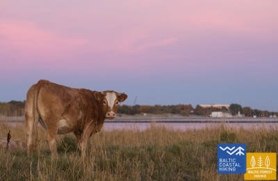
Section 22. Dubulti - Lielupe - Bulduri.
The Most Popular Beaches in Latvia
The widest sandy beach of the Gulf of Riga stretches from Dubulti to the Lielupe River. It is the main asset of the Jūrmala resort offering many beach cafés and different recreational possibilities. The coastal dune forests are permeated with a dense web of trails suitable for walking and stick-walking. The part of the Baltic Coastal Hiking Route located between the beach of the Lielupe River and Jūrmala beach is part of the Ragakāpa Nature Park. From here, you can easily get back to Bulduri by taking Bulduri prospekts and the 5th line.
Jūrmala is convenient for easy and short hikes along its sandy beach, through pine forest-covered dunes (with a network of trails), or along the city's pedestrian streets and parks. You can choose walks of varying lengths, combining them with train rides (with stops spaced 1.5 - 2 km apart) or city buses.
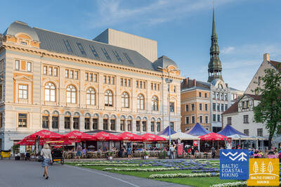
 Section 24. Riga City Center - Vecāķi.
Riga Old Town – a UNESCO World Heritage site
Initially, the itinerary takes you on a small stroll around Riga City Center, Riga Old Town, leads along the City Canal through Kronvalds Park, via Alberta iela (Art Nouveau buildings) and further on via Miera iela through the Lielie kapi Cemetery, via Kokneses and Ostas prospekts through Mežaparks and then it reaches Jaunmīlgrāvis and crosses Mīlgrāvis . Then it meanders along Vecāķu prospekts up to Ziemeļblāzma and the banks of the Old Daugava River (Vecdaugava) separated by only a couple of kilometers from Vecāķi. After a two-day hike through Riga, the Baltic Coastal Hiking Route leads you out to the beach again.
In Mežaparks, which is traversed by the Coastal Trail, there is a dense network of paths suitable for parents with strollers. Everyone can choose a walking or hiking route according to their preferences and abilities.
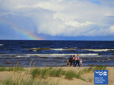
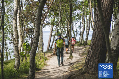
Section 25. Vecāķi - Carnikava.
Between The Estuaries Of Two Rivers: The Daugava River And The Gauja River
This sections of the Baltic Coastal Hiking Route is a comparatively short hike across a beautiful sandy beach, the coastal side of which is bounded by brightly colored pine forests with spectacular dunes and dams of dunes. To get from the beach to Carnikava, the Baltic Coastal Hiking Route will take you through a forest via a promenade. Then it takes a stroll around the Old Gauja River via a levee and reaches the pedestrian bridge over the Gauja River. Both as you start and end the hike, it is nice to sit in one of the pubs and summer cafés located on Vecāķi beach and in Carnikava.
The areas of Vecāķi, Kalngale, and Carnikava (including the Carnikava Promenade) are suitable for walks and short hikes of varying lengths, both along the coastline and through the light pine forests. The railway is conveniently accessible, with stations located approximately every 2.5 - 3.5 km.
Section 27. Saulkrasti – Lauči.
The Gate To The Rocky Seashore Of Vidzeme
The first kilometers leading up to Zvejniekciems can be covered via the beach or via a trail meandering through the dune forest with old pines whose bark looks like crocodile skin. Here you can also see an old wooden hut with fishing nets and tools. Before reaching the port of Skulte, the first rocks appear on the beach of Zvejniekciems. After making a detour around the estuary of the Aģe River and the port, the Baltic Coastal Hiking Route returns to the beach where you can already see Cape Ārņi from afar, while beyond it the brown back of the Big Lauči Sea Boulder comes into view. Varied coastal landscapes.
Saulkrasti - both the pine-covered dunes and the beach - are suitable for walks and short hikes of varying lengths, which can be combined with the city’s public transportation.
Section 34. Uulu - Pärnu.
Along the Wetlands to Pärnu
First, the Baltic Coastal Hiking Route takes the old coastal roads surrounded by pine forests, but after passing Lottemaa Park it turns towards the sea and comes out at Reiu beach. Next, the hike continues across an overgrown beach (wide shoals when the winds create an outflow of water) and after a little less than 4 km you have to turn inland, cross a golf course and turn in the direction of Pärnu. Near the Raeküla district, it snakes along a small trail forming the border between the large coastal wetland and the forest. Having looped around the wetland for ~ 6 km, the Baltic Coastal Hiking Route emerges at Pärnu beach. Further on, the road goes through the western part of Pärnu Old Town, crosses the Pärnu River and the Sauga River and ends in the Vana-Pärnu district.
The parks and coastal promenades and beach in Pärnu are suitable for hikes and walks of various lengths.
Section 48. Rohuküla - Haapsalu - Uuemõisa.
The Most Popular Resort in Estonia - Haapsalu
A multifarious section of the Baltic Coastal Hiking Route. The first three kilometres of the itinerary go along the former Haapsalu – Rohuküla broad-gauge railway line, takes you on a stroll along Haapsalu Bay through Pullapää cape, crosses coastal forests, which contain health trails, and continues via coastal promenades and small streets around Haapsalu Town. After crossing a small wetland beyond the town, this section of the trail ends in the beautiful Uuemõisa Park.
Trails have been created in the forests around Haapsalu. The city is interwoven with a network of pedestrian sidewalks and coastal promenades. Here, you can go for walks and hikes of various lengths.
Section 57. Kersalu - Laulasmaa.
Beaches, Swimming Areas and a Resort
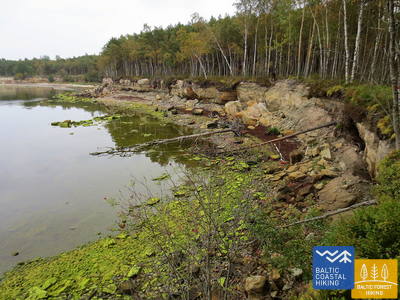
The itinerary leads along the seashore and small coastal villages. Near Kersalu, the Baltic Coastal Hiking Route approaches a rocky shore, where among the trees you will see cliffs rising several meters. When approaching Kloogaranna, wide sandy beaches and dunes appear. Near Kloogaranna beach, the Baltic Coastal Hiking Route turns towards a village, takes you on a stroll of ~ 3 km through the inland and then returns to the seashore.
A short section with beaches and pedestrian paths, wooden boardwalks, where everyone, depending on their abilities, can choose walks or hikes of various lengths.
Section 58. Laulasmaa - Vääna-Jõesuu.
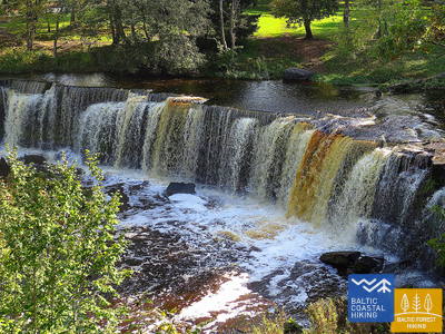
The Most Beautiful Waterfall in Estonia
A multifaceted section of the Baltic Coastal Hiking Route in terms of landscape that is suitable for hardy hikers. There are both rocky and sandy beaches and good swimming areas, fascinating coastal pine forests, the astounding Türisalu Cliff wall and giant sea boulders. By taking the trails of the vast Keila forest park, you can go to the Keila waterfall, near which some fragments of the popular Latvian feature film Vella kalpi (Devil’s servants) were shot, and you can also get to know the exhibition dedicated to the life of coastal fishermen in Lohusalu village.
Keila Park is suitable for walks of various lengths.
Section 59. Vääna - Jõesuu - Tabasalu.
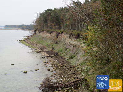
The Fabled Suurupi Peninsula
One of the most complicated sections of the Baltic Coastal Hiking Route, suitable only for experienced hikers. The itinerary circles the Suurupi Peninsula where the dense forests conceal the military heritage of different eras. The Baltic Coastal Hiking Route meanders through overgrown and rocky seacoasts, birch groves, along former pioneer camps and sand-stone cliffs protecting coves with sharp capes. In some places, the sea uncovers its dolomite base, while in other places you can see boulder “islands”. At the end of the itinerary, one of the most astounding outcrops of the Estonian littoral rises before your eyes – the Rannamõisa Cliffs, which gives views of Kakumäe Bay and Peninsula and the towers of Tallinn’s Old Town.
The area has a dense network of trails and small paths, as well as pedestrian sidewalks, which are suitable for short hikes and walks.
Section 60. Tabasalu - Tallinna sadam.
Tallinn – A UNESCO World Heritage Site
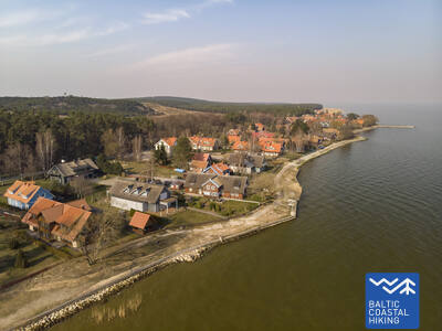
Near Tabasalu, the Baltic Coastal Hiking Route crosses the boundary of Tallinn and goes through the Tiskre and Vismeistri districts to reach Kakumäe beach, where it takes you on a stroll around the wooded upper part of the Kakumäe Peninsula surrounded by cliffs. Here, you will have a vista of the Port of Tallinn across Kopli Bay. Opposite the Õismäe district, an excellent promenade goes along the seashore. After bypassing the Estonian Open-Air Museum, the Baltic Coastal Hiking Route winds along the coastal promenade up to Stroomi beach and after passing the Pelguranna district it takes pedestrian sidewalks to the Estonian Maritime Museum, where it leads you, via the coastal promenade, to the Port of Tallinn, marking the end of the Baltic Coastal Hiking Route. You have covered ~ 620 km in Estonia.
The Harku health trail, the Estonian Open Air Museum, the "Rocca al Mare" promenade, and the old town are suitable places for walks and hikes of various lengths.
Section 64. Nida – Pervalka.
Along the coast of the Curonian Lagoon
The Baltic Coastal Hiking Route starts in the center of Nida, by the port. In Nida, the trail winds along the Curonian Lagoon walkway which offers beautiful views of the expansive waters all the way to Rusnė Island on the east coast of the Curonian Lagoon. Nida features the typical architecture of the Curonian Spit region — one-storey wooden buildings with tile or reed roofs and window shutters painted blue and white. From Nida to Bulvikis Cape (shortly before the cape there is an abandoned runway), the Baltic Coastal Hiking Route winds through single-track forest trails up and down the pine-covered dunes, occasionally coming out onto beachside meadows with scarce vegetation. Rest spots and bird watching towers are available along the trail. The next section features unique open seaside meadows covered in lichens and vegetation characteristic to the Curonian Spit. The Baltic Coastal Hiking Route follows the coastal walkway in the village of Preila. It then winds through forest trails, briefly also following a pedestrian/cyclist lane and coastal paths, eventually reaching Pervalka. This section leads through the Curonian Spit National Park.
The Curonian Lagoon (Kuršių marios) promenade in Nida is suitable for short walks.
Section 65. Pervalka – Juodkrantė.
Along the most majestic sand dunes in Northern Europe
Having departed Pervalka, the Baltic Coastal Hiking Route follows a pedestrian path to cross the Curonian Spit in an east–western direction, arriving at the coast of the Baltic Sea. The next section of 13 km leads along a beautiful, sandy beach protected by high and steep sand dunes on the east. It is called the protective dune ridge and it has been man-made in order to protect the inland from the movement of sand. Entering Juodkrantė, the Baltic Coastal Hiking Route turns eastward and crosses the Curonian Spit once again over wooded and steep dunes, to reach the Curonian Lagoon coast. The Baltic Coastal Hiking Route briefly coincides with the Hill of Witches trail. It then follows the Juodkrantė beachside walkway to the port. This section leads through the Curonian Spit National Park.
Jodkrantė's Curonian Lagoon (Jodkrantės Kuršių marių ) promenade and the Witch's Hill (Raganų kalnas) trails are suitable for short walks.
 Section 67. Klaipėda – Palanga.
Through the Seaside Regional Park
Following H. Manto Street, the Baltic Coastal Hiking Route leads out of the center of Klaipėda, traverses the Klaipėda Recreation Park, crosses a railway line by bridge and comes out onto the coast of the Baltic Sea in the southern part of Melnragė. The trail then winds through the dunes, for the protection of which wooden walkways have been installed, and continues on along a beautiful path through the coastal forest, following at a distance of about 10–20 m the pedestrian/cyclist lane through Antroji Melnragė to Giruliai. At Giruliai, it briefly comes out onto the beach, but from Kukuliškiai to the southern part of Karklė Village, the Baltic Coastal Hiking Route first passes along the incredibly beautiful coastline of the former Littorina Sea covered in primeval forest, and later, along a scenic bluff, created by the washing of waves; there are several viewing points along the way (including the Dutchman's Cap). From the Village of Karklė for the next 11 km to the Palanga Botanical Park, the Baltic Coastal Hiking Route leads across sandy and pebbly, occasionally rocky beaches. Through the coastal pathways in the western part of the Palanga Botanical Park, the trail leads over to Meilės avenue and then to the Palanga pedestrian bridge. Most of this section of the trail leads through the Seaside Regional Park.
Palanga Botanical Park is suitable for short walks and hikes.