


Baltic Coastal Hiking trail - Harjumaa & Tallinn

Cliffs and waterfalls of Northwestern Estonia
The littoral of the Gulf of Finland
Nõva – Tallinn: 158 km, Day 53 – Day 60
The most multifaceted section of the Baltic Coastal Hiking Route in Estonia where you can feel the Northern nature. Here you can see boulders, sandy beaches, grassy coastal meadows and the so-called breccias: pieces of rocks that have resulted from an ancient meteorite explosion. Pakri Cliff is located here: it is the most spectacular coastal cliff wall in the Baltic States reaching a height of 24 m. The itinerary goes near the seacoast, occasionally taking forest and country roads. Manors, churches and lighthouses appear in the landscape, as well as Pakri windpark. You can visit the picturesque Keila-Joa waterfall and mysterious Pakri islands. A lot of military heritage sites have been preserved around Tallinn: coastline fortifications and coastal protection batteries. During the Soviet times, city of Paldiski was a closed town and a top secret military site with a specially built nuclear submarine reactor: a training centre for military specialists. The Baltic Coastal Hiking route ends in the centre of Tallinn, the Medieval Old Town which is a UNESCO World Heritage Site.
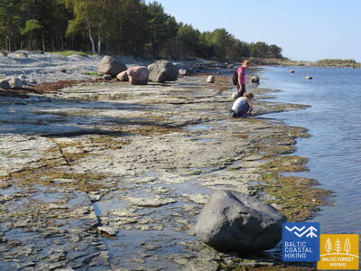
 Section 53. Nõva - Vihterpalu.
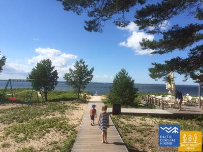
Along the Gulf of Finland
Starting from Rannaküla and after bypassing the wetland, the Baltic Coastal Hiking Route crosses the small Nõva River and leads you to the beach at Keibu Bay (overgrown at the beginning) where a sandy seashore with dunes stretches before your eyes. Near Keibu Brook, it turns inland where its continuation coincides with the trail marked by the Estonian State Forest Management Centre: Peraküla – Aegviidu – Ähijärve. The trail snakes through the small Keibu village and emerges at the beach opposite Alliklepa village with beautiful juniper fields. Further on, the trail leads you between the sea and two small lakes that used to be coves. Opposite them, you will see dolomite outcrops in the seabed. Next, the trail takes a small road along the seacoast (you can see the Pakri Islands) until reaching Vintse village and then it turns towards Vihterpalu.
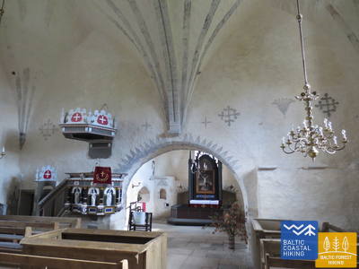
Section 54. Vihterpalu - Padise.
A Seven Centuries Old Church and Monastery
The south shore of the Kurkse Strait is covered in wetlands, so the Baltic Coastal Hiking Route turns inland. The greatest part of the Baltic Coastal Hiking Route leads you through large, sparsely inhabited tracts of forest (corresponding with the trail created by the Estonian State Forest Management Centre: Peraküla – Aegviidu – Ähijärve) and sometimes takes you to a more open space or a village.
Section 55. Padise - Paldiski.
Paldiski: The Former Closed and Top Secret Town
Starting from Padise up to Karilepa, the Baltic Coastal Hiking Route winds through small country roads, while further on to Madise it goes along the side of the road. From the ancient seacoast of the Madise church hill, you will have magnificent views of Paldiski Bay and the Pakri Islands. From Madise to Paldiski, the itinerary continues along the side of the abovementioned road up to the South Harbour and, by going along it, the route reaches the railway station located in the southern part of Paldiski. During Soviet times, Paldiski was a closed town with a military port and a nearby nuclear submarine training base at the Pakri Peninsula that operated using a small nuclear reactor.
Section 56. Paldiski - Kersalu.
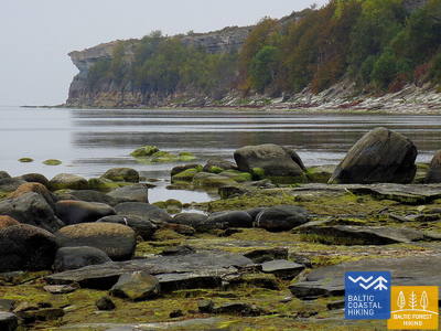
Cliffs, a Lighthouse and Military Heritage
The Baltic Coastal Hiking Route leads around the Pakri Peninsula, from whose rocky shores you will discover the most beautiful coastal landscapes in northwest Estonia. It goes through the centre of Paldiski and, after having reached the fortress bastions of Peter I, it turns towards the Pakri Lighthouse going across the upper part of the impressive Pakri Cliffs. Further on up to Kersalu, there are both ups in the shape of rocks and downs where the Baltic Coastal Hiking Route meanders along a sandy and rocky seacoast and a beautiful pine forest. Pakri Cliffs are alluring both in cold winters, when impressive icefalls are formed here, and during the time of colourful leaves in autumn.
 Section 57. Kersalu - Laulasmaa.
Beaches, Swimming Areas and a Resort
The itinerary leads along the seashore and small coastal villages. Near Kersalu, the Baltic Coastal Hiking Route approaches a rocky shore, where among the trees you will see cliffs rising several meters. When approaching Kloogaranna, wide sandy beaches and dunes appear. Near Kloogaranna beach, the Baltic Coastal Hiking Route turns towards a village, takes you on a stroll of ~ 3 km through the inland and then returns to the seashore.
Section 58. Laulasmaa - Vääna-Jõesuu.
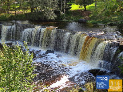
The Most Beautiful Waterfall in Estonia
A multifaceted section of the Baltic Coastal Hiking Route in terms of landscape that is suitable for hardy hikers. There are both rocky and sandy beaches and good swimming areas, fascinating coastal pine forests, the astounding Türisalu Cliff wall and giant sea boulders. By taking the trails of the vast Keila forest park, you can go to the Keila waterfall, near which some fragments of the popular Latvian feature film Vella kalpi (Devil’s servants) were shot, and you can also get to know the exhibition dedicated to the life of coastal fishermen in Lohusalu village.
Section 59. Vääna - Jõesuu - Tabasalu.
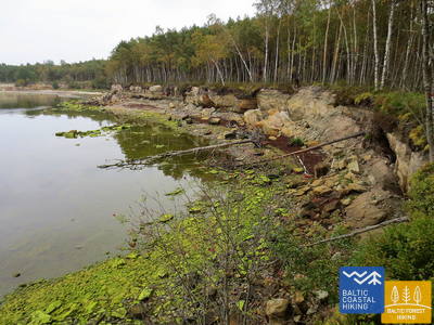
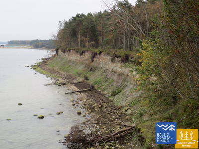
The Fabled Suurupi Peninsula
One of the most complicated sections of the Baltic Coastal Hiking Route, suitable only for experienced hikers. The itinerary circles the Suurupi Peninsula where the dense forests conceal the military heritage of different eras. The Baltic Coastal Hiking Route meanders through overgrown and rocky seacoasts, birch groves, along former pioneer camps and sand-stone cliffs protecting coves with sharp capes. In some places, the sea uncovers its dolomite base, while in other places you can see boulder “islands”. At the end of the itinerary, one of the most astounding outcrops of the Estonian littoral rises before your eyes – the Rannamõisa Cliffs, which gives views of Kakumäe Bay and Peninsula and the towers of Tallinn’s Old Town.
Section 60. Tabasalu - Tallinna sadam.
Tallinn – A UNESCO World Heritage Site
Near Tabasalu, the Baltic Coastal Hiking Route crosses the boundary of Tallinn and goes through the Tiskre and Vismeistri districts to reach Kakumäe beach, where it takes you on a stroll around the wooded upper part of the Kakumäe Peninsula surrounded by cliffs. Here, you will have a vista of the Port of Tallinn across Kopli Bay. Opposite the Õismäe district, an excellent promenade goes along the seashore. After bypassing the Estonian Open-Air Museum, the Baltic Coastal Hiking Route winds along the coastal promenade up to Stroomi beach and after passing the Pelguranna district it takes pedestrian sidewalks to the Estonian Maritime Museum, where it leads you, via the coastal promenade, to the Port of Tallinn, marking the end of the Baltic Coastal Hiking Route. You have covered ~ 620 km in Estonia.