


Baltischer Wald-Wanderweg - Kaunas

Kaunas und Bezirk Kaunas
Von grün Umgebene malerische Kleinstädte und die Zwischenkriegsarchitektur am zusammenfluss zweier Flüsse
Pakuonis – Kaunas – Lampėdis – Kulautuva – Vilkija: 79 km, 5 Tage.
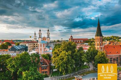
Kaunas, eine der schönsten Städte Litauens, liegt am Zusammenfluss der Flüsse Nemunas und Neris. Es ist die zweitgrößte Stadt Litauens, die Hauptstadt der Provinz Kaunas während des Russischen Reiches (1842–1915) und im Zeitraum 1919– 1940 – die zeitweilige Hauptstadt Litauens. Panemunė Heide ist der größte Park in Kaunas mit Stränden am Ufer des Nemunas, Radwegen und Pfaden für Spaziergänge. Der Lampėdis-See mit einer Fläche von 125 ha entstand auf dem Gelände des ehemaligen Kiesbruchs. An seinen Ufern befinden sich die von den städtischen Bewohnern beliebten Erholungs- und Badeorte. Nach Vilkija führt ein Fußgänger- und Radweg entlang des Ufers des Nemunas mit schöner Aussicht über den Fluss, mit einem Bogen durch den Kurort Kulautuva. Auf dem weiteren Weg nach Vilkija ist eine abwechslungsreiche Landschaft mit kleinen Siedlungen, Burghügeln und Wäldern zu genießen.
 62. Etappe. Pakuonis – Vaišvydava.
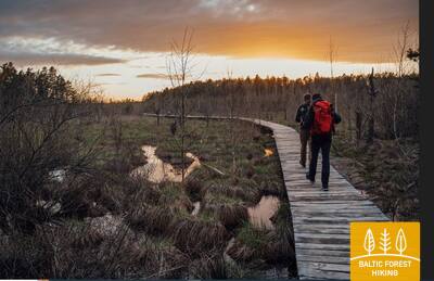
Durch den Regionalpark des Kaunasser Meeres (Stausee)
Vom Stadt Pakuonis geht der Wald-Wanderweg weiter auf der Kauno Straße (Nr. 1901) in nordwestlicher, nördlicher Richtung und erreicht nach 7 km das Stadt Piliuona. Nach Piliuona geht es die Nemuno Straße entlang und nach ca. 1,6 km biegt er links in Richtung Dubravai ab. Nach der Durchquerung des Waldmassivs führt der Wald-Wanderweg nach etwa 2,4 km zum Dorf Dubravai, windet sich entlang seiner Hauptstraße und erreicht nach 3 km (Klonio-Straße, Nr. 1937) das Dorf Vaišvydava, wo sich das Besucherzentrum des Regionalparks Kaunas befindet.
63. Etappe. Vaišvydava – Kaunas.
Durch die Parks von Kaunas
Vom Besucherzentrum des Regionalparks vom Kaunasser Meer führt der Wald-Wanderweg durch den Wald Rokų und entlang der Straßen Miškininkų, Kelmyno, Muraškinės, Žarstos, Garšvės und Rokelių, macht ein Bogen um die Vororte von Kaunas, überquert die Marijampolė- Straße (Nr. 139) und geht weiter in Richtung Balčkalnio-Straße zum Stadtteil Panemunė. Am Stadion der Technischen Schule für Ingenieurwesen der Technischen Universität Kaunas geht es bergab zur Vaidoto-Straße, dann weiter auf dem Bürgersteig zur Baterijos-Schnellstraße, wo er nach links abbiegt. Etwa ein Drittel der Stadtfläche von Kaunas wird von Parks und anderen Naturgebieten eingenommen. Der Wald-Wanderweg durchquert die Stadt durch ihre grünsten Teile. Auf einer Länge von etwa 2,5 km führt der Wald-Wanderweg durch den Panemunės Hain, der über ein dichtes Netz von Wegen, Rastplätzen und einen Strand verfügt. Der Wald-Wanderweg überquert den Fluss Nemunas über die Drei-Mädchen-Brücke, führt dann durch das Wohngebiet Gričiupis, führt entlang des Zoos von Kaunas, durchquert den riesigen Ozolu-Park und führt durch den Vytauto-Park hinter der litauischen Sportuniversität. Es geht die Treppe im Park hinunter zum Anfang der Laisvės Allee und führt weiter zum Ziel des Abschnitts im Zentrum von Kaunas.
WICHTIG. Auf den Abschnitten, die die Stadt Kaunas durchqueren, gibt es keine Markierungen.
64. Etappe. Kaunas – Lampėdžiai.
Durch das historische Zentrum von Kaunas
Kaunas ist die zweitgrößte Stadt Litauens. Auf der 1621 m langem Laisvės- oder Freiheits-Straße ist ausgezeichnete modernistische Architektur der Zeitperiode 1914 –1940 zu sehen, die zum europäischen Kulturerbe gehört. Die Vilniaus-Straße ist das „Tor“ zur mittelalterlichen Stadt Kaunas, die von hanseatischen Kaufleuten bewirtschaftet wurde. Der Wald-Wanderweg verläuft entlang der Laisvės-Straße, durchquert die Altstadt von Kaunas mit Kirchen, dem Rathausplatz und historischen Gebäuden und beschreibt einen Bogen entlang des Santakos-Parks, wo Litauens größter Fluss, die Nemunas und die Neris, zusammenfließen. Nachdem er den Fluss Neris überquert hat, führt der Wald-Wanderweg über Fuß- und Radwege weiter zum 4 km entfernten ehemaligen Kiesbruch Lampėdis, der überflutet worden ist und heute ein beliebter Erholungs- und Badeplatz für die Anwohner ist.
WICHTIG. Auf den Abschnitten, die die Stadt Kaunas durchqueren, gibt es keine Markierungen.
65. Etappe. Lampėdžiai – Kulautuva.
Entlang dem Ufer der Nemunas
Die ersten 2 km schlängelt sich der Wald-Wanderweg am Nordufer des Lampėdis-Kiesbruchs entlang und führt zur Schnellstraße gegenüber dem Friedhof. Weiter der Straße entlang in Richtung Raundondvaris überquert der Wald-Wanderweg nach 1,7 km den Fluss Nevėžis. Nach 0,6 km biegt der Wald-Wanderweg links in die Pakalnės-Straße ab und verläuft auf kleinen Wegen am rechten Ufer des Flusses Nemunas gegenüber der Mündung des Flusses Nevėžis entlang. An den Ufern des Nemunas-Tals sind die Orte alter Burghügel zu sehen. Hinter dem Dorf Šilelis geht der Wald-Wanderweg auf einem Fuß-/Radweg weiter bis zum Städtchen Kulautuva, vor dem wieder ein Bogen auf einen kleinen Waldweg geworfen wird. Dann bewegt sich der Wald-Wanderweg durch die Straßen Pušyno und V. Augustausko, wo er das Ziel dieses Abschnitts erreicht.
WICHTIG. Auf den Abschnitten, die die Stadt Kaunas durchqueren, gibt es keine Markierungen.
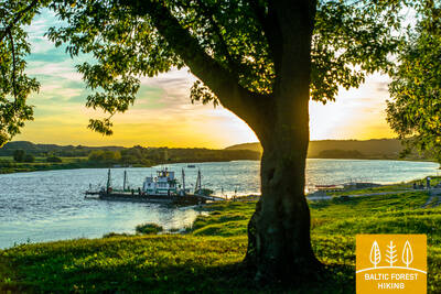
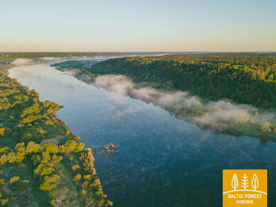
66. Etappe. Kulautuva – Vilkija.
Entlang der Auewiesen von Nemunas
Auf der ganzen Länge von diesem Abschnitt führt der Wald-Wanderweg über Pfade und kleine Schotterwege entlang des rechten Ufers des Flusses Nemunas. Schöne Landschaften mit Blick auf den Fluss, Uferwiesen und kleine Dörfer. Das Ziel des Abschnitts - die Vilkija-Fähre ist schon von weitem am Ufer der Nemunas zu sehen. Gegenüber der Fähre befindet sich das Zentrum der Kleinstadt mit einer Kirche. In der zweiten Sommerhälfte versinken die Wiesen der Nemunas in gelber und blauer Farbe von Blumen. Es lohnt sich, eine Fahrt mit der Fähre hin und zurück auszuprobieren, da ein solches Fahrzeug nur an wenigen Orten im Baltikum erhalten geblieben ist.