


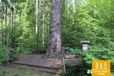
Metsa matkarada - Ratastooliga läbitav


 1. päev. Riia vanalinn ‒ Baltezers.
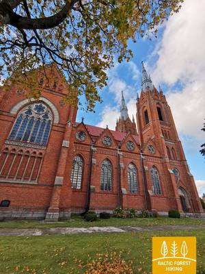
Läbi Riia ‒ UNESCO maailmapärandi meistriteos
Metsa matkaraja alguspunkt Lätis asub Riia vanalinnas, Raekoja platsil. Rada kulgeb piki Kaļķu tänavat, mööda Vabadussambast, läbi Vērmane aia ja jätkub Tērbata (Tartu) maanteel, ületab Zemitāni raudteejaama jalakäijate silla ning suundub Biķernieki ja Šmerlise metsadesse. Tee läbib Läti etnograafilise vabaõhumuuseumi ja kulgeb mööda kergliiklusteed Baltezersi külani.
The "Feel Jugla" Walking Trail

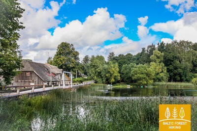
Jugla järve kirdeossa Juglas on rajatud 250-meetrine puidust laudtee (üks suund) vaateplatvormiga Jugla järvele, pink, 20 kombatavat ruumireljeefi, mis kujutavad järve ja selle ümbruse iseloomulikke loomaliike ning teave punktkirjas. See on ligipääsetav ratastoolis inimestele. Koht asub Mežtaka rajast 0,5 kilomeetri kaugusel.


 4. päev. Rāmkalni‒Sigulda.
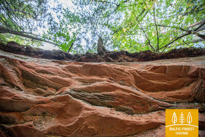
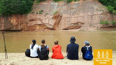
Maaliline Gauja jõe ürgorg Sigulda lähedal
Metsa matkarada kulgeb sel päeval Gauja jõe ürgoru järskudel nõlvadel, läbib Gauja küla ja suundub seejärel oru põhja, kus ületab Lorupe jõe ja jätkub Gauja jõe käänulistel kallastel. Rada möödub Velnala paljandist, ühest kauneimast liivakivipaljandist Gauja jõel. Seejärel suundub matkarada Ķeizarskatsi vaateplatvormile ja keerleb siis allapoole Ķeizarkrēslsi külla, möödudes Sigulda seikluspargist „Tarzan“ ja Sigulda bobi- ja kelgurajast.
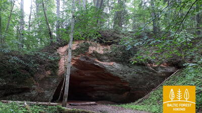
Trail to Gutman's cave
Gūtmaņala külastuskeskuse parklast (GPS: 57.176245, 24.846747) viib rada ühe Gauja rahvuspargi populaarseima vaatamisväärsuse – Gūtmaņala juurde. Raja katteks on killustik, asfalt laiusega 1,15 kuni 2 meetrit. Rada on 0,5 kilomeetri pikkune (edasi-tagasi) ja sinna pääsevad ratastoolis inimesed koos kaaslasega. Tunnelis olev lift ei tööta! Vaja on ületada tänav, kus on väike äärekivi! Olemas on kohandatud tualettruum. Rada asub Mežtaka rajast 2,7 kilomeetri kaugusel.


5. päev. Sigulda‒Līgatne.
Gauja rahvuspargi südames
Pärast Siguldat suundub metsa matkarada piki Vējupīte jõge Maalilise mäeni, kus järsk trepp viib alla Gauja jõe ürgorgu ja Vējupīte jõe sügavasse orgu. Seejärel lookleb rada üle niitude, ületades mõned väiksemad jõed, mille kallastel kõrguvad liivakivipaljandid. Teekonna viimased 6 km kulgevad mööda Līgatne loodusrada. Līgatnele lähenedes suundub metsa matkarada Gauja oru kõrgematele kallastele, kuni laskub taas alla, Līgatne jõe sügavasse orgu, kus asub endine Līgatne paberitööstus.
Trail to Paradise Hill
Miera tänava parklast (GPS: 57.170624, 24.862061) saate Gleznotājkalnsiga tutvuda mööda umbes 2 kilomeetri pikkust ringmarsruuti. Rada on ligipääsetav ratastoolis inimestele ja käruga lapsevanematele. Pinnas on asfalt, kruus ja laudteed (sillad). Rada on märgistamata, kuid ristmikel on viidad. Lõik parklast Gleznotājkalnsini langeb kokku Mežtaka rajaga.
Līgatne Nature Trails
Līgatne loodusrajad on Gauja rahvuspargi üks populaarsemaid vaatamisväärsusi, kus Läti metsadele omased loomad elavad oma looduslikule elupaigale lähedastes tingimustes. Ratastooliga inimestele on ligipääsetavad kaks rada "Pauguri" külastuskeskuse juurest: üks viib karude aedikuni (300 meetrit üks suund) ja teine rebaste aedikuni (600 meetrit üks suund). Külastuskeskuses on kohandatud tualetid ja määratud parkla (GPS: 57.248149, 25.014735). See asub Mežtaka raja kõrval.


 6. päev. Līgatne‒Cēsis.
Piki vana Cēsise teed läbi Amata jõe oru
Metsa matkaraja üks kõige maalilisemaid lõike kulgeb läbi Līgatne paberivabriku ajaloolise töölisküla, möödub Spriņģi paljandist, tiirutab mööda Skaļupe matkarada ja mütoloogilist rada, põikab läbi ühest Nõukogude aja kõige salajasemast kohast – suurest maa-alusest punkrist ‒ siinpool raudset eesriiet ning suundub edasi Roči looduskaitsealale, ületab Amata jõe (selles lõigus on Amata kõige ilusam ja paljandirohkem) ning jõuab lõpuks välja Zvārte paljandini. Järgmiseks kulgeb metsa matkarada Amata oru kõrgetel kallastel ning suundub mööda ajaloolist Cēsise–Riia “maanteed” (praegu väike külavahetee, mille ääres on vanad teetähised) Rakšisse, tõuseb üles Vāļukalni mägedele ja Ozolkalnsi. Gauja jõe kaldaid pidi edasi suundudes kohtub metsa matkarada Cīrulīši loodusradadega. Päeva teekond lõpeb Gauja tänaval, kuid matkajad võivad kõndida rada mööda edasi Cēsisesse (2,8 km), veeta seal öö ning jätkata sealt järgmisel päeval teekonda.
The trail to Zvanu Cliff
900 meetri pikkune rada viib Gauja oru peakalda nõlvale, kus kõrguvad Zvanu kaljud ja kus asub vaateplatvorm. Rada on 1,5 meetri laiune puidust laudteekattega. Rada on ratastoolis inimestele ligipääsetav kaaslase abiga, kuna rajale pääsemiseks tuleb ületada äärekivi ning kalle on kohati liiga järsk. Parkida ega tualettruumi pole. Selle kõrval tee servas on liivane "tasku", kuhu saab auto jätta. Rada asub Metsaraja kõrval.


7. päev. Cēsis‒Caunītes.
Muljetavaldavad liivakivipaljandid Gauja jõel
Metsa matkarada kulgeb väikestel metsateedel kuni „Lenči“ kämpinguni, tiirutab läbi muutuva maastiku Ērģeļu paljandini ja laskub siis Gauja jõe ürgorgu. Pärast Ērģeļu paljandit suundub rada tagasi Cēsise suunas, kuid keerab Pieškalnsis ära Rāmnieki suunas, ületades Gauja jõe. Olles möödunud Jāņrāmise kämpingust, jõuab metsa matkarada ilusasse valgusrikkasse männimetsa ning kulgeb läbi metsa Caunītese turismitaluni. See on üks kõige ilusamaid kohti Gauja jõe kallastel.
Ērgļu (Ērģeļu) Cliffs Nature Trail
Rada tutvustab külastajatele Läti üht muljetavaldavamat liivakivipaljandit. See ühendab kaljud parklaga (GPS: 57.357495, 25.262360). 460 meetri pikkune rada (ühesuunaline) kulgeb mööda metsarada ja sobib abiga ratastoolis liikujatele. Rada on väga järsk! Olemas on kohandatud tualettruum. Rada ühtib Mežtaka rajaga.


9. päev. Valmiera‒Strenči.
Piki Abulsi jõe kallast Strenčisse, parvepoiste pealinna
Matkarada suundub läbi Valmiera ajaloolise südame ja Atpūtase pargi, mis on matkajate ja kepikõndijate meelispaik. Seejärel ületab rada jalakäijate silla ning möödub Pauku männikust ja Baiļu mägedest. Siit alates langeb metsa matkarada kokku Abulsi matkarajaga, mis tiirutab jõe kallastel kuni jõuab Brenguļi pruulikojani. Sealt edasi, pärast Pūpoli suvilarajooni, viib rada matkaja läbi ulatuslike inimasustuseta metsade. Raja esimene pool kulgeb läbi väikeste suvilarajoonide (nt Enerģētiķis, Saulītes, Sprīdītis, Gaujmaļi, Pūpoli ja Gaujaslāči), mis rajati nõukogude ajal Valmiera ja ümbruskonna inimeste suvitusaladeks. Ūdriņase lähedal läbib matkarada jõesängide labürindi ning keerab põhja poole, ületades Gauja jõe paatide vettelaskmis- ja puhkekoha juures. Strenči keskus on siit 1,5 km kaugusel. Osa päevateekonnast kulgeb Põhja-Gauja maastikukaitsealal.
Strenči Nature Trail and Wooden Sculpture Park
Raja teemaks on Gauja parvetajad, millel on umbes 30 skulptuuri. Rada saab alustada Ozolu tänava parklast (GPS: 57.623436, 25.690133). Sellel on kaks, 5 ja 7 kilomeetri pikkust aasat, kuid ratastoolis inimestele koos abiga sobiv lõik on suhteliselt lühike. See asub 0,7 km kaugusel Metsarajast.


10. päev. Strenči ‒ Spicu sild.
Läbi ilusate Vidzeme metsade
Selles lõigus langeb metsa matkarada kokku Gauja matkarajaga, mis kulgeb otse Gauja jõe kallastel. Kahes kohas ületab metsa matkarada A3 maantee (enne Seda linna keeramist ja enne Kaučit – ole ettevaatlik!) ning jätkub väikestel metsateedel liiva-kruusakarjäärini, keerates seejärel Oliņasse suunduvale kruusateele. 3,5 km pärast keerab rada taas paremale ja suundub väikeseid ja üksildasi metsateid pidi Spicu sillani, kus Zemā saare ehk Madala saare juures avanevad Põhja-Gauja (Ziemeļgauja) maastikukaitseala kõige ilusamad vaated. Päevateekonna lõpus, kus maantee P24 kulgeb Spicu silda pidi üle Gauja jõe, on telkimis- ja piknikuplats.
The rest area by Spicu Bridge
Metsaraja ääres asuv puhkeala on ligipääsetav ratastooliga inimestele. Paigaldatud on spetsiaalsed lauad ja tualettruum on kohandatud.


11. päev. Spicu sild ‒ Zaķi.
Üle võimsate Cirgaļi luidete
Metsa matkarada kulgeb üle Spicu silla ja viib nelja Kokši järve juurde, mis on omavahel ühendatud väikese ojaga. Siin on telkimis- ja piknikuplats ning loodusrada. Ümbritsev loodus on väga kaunis ning metsad on täis häid söögiseeni. Pärast viimast Kokši järve, Dibenat, jõuab rada tunni või paari pärast Cirgaļi luitemassiivini ning ületab selle põhja-lõunasuunaliselt. Ülejäänud osa metsa matkarajast kulgeb läbi suure metsamassiivi, siin-seal on näha mõned üksiktalud või väikejärved. Päevateekond lõpeb väikeses Zaķi külas. Külas puuduvad teenused, seega mõtle oma matka kavandades hoolikalt läbi kõik, mida vajad ning tee vastavad kokkulepped. Rada kulgeb Põhja-Gauja (Ziemeļgauja) maastikukaitsealal.
The rest area by Spicu Bridge
Metsaraja ääres asuv puhkeala on ligipääsetav ratastooliga inimestele. Paigaldatud on spetsiaalsed lauad ja tualettruum on kohandatud.
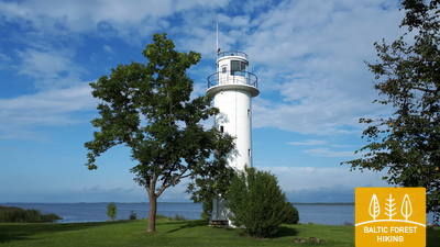
22. päev. Ristipalo‒Mehikoorma.
Peipsi järve-äärsetel poldritel
Umbes pool päevateekonnast möödub Räpina poldri nöörsirgetel teedel. Peipsi järve rannikumadalikul asuv polder on rajatud nõukogude ajal ümbritsevate rohumaade kuivandamiseks. Kõrge tamm kaitseb kevadiste üleujutuste eest. Poldritel on põllud ja karjamaad. Nahast Mehikoormani kulgeb matkarada Räpina-Mehikoorma maantee ääres, Mehikoorma tuletornist avaneb kena vaade Lämmijärvele. See on Peipsi ja Pihkva järvede vahel asuv kitsam järveosa. Teisel pool Lämmijärve, 1,7 km kaugusel on Venemaa.
Mehikorma Harbor Shore Promenade
Mehikorma sadama ja tuletorni vahele on loodud loodusrada ja promenaad, mis tutvustab 1,3 km ulatuses Peipsi järve rannajoont. Osa sellest, sealhulgas promenaad ja laudtee, on ratastooliga inimestele ligipääsetavad kaaslase abiga. See asub metsaraja kõrval.
23. päev. Mehikoorma‒Lääniste.
Läbi Emajõe Suursoo
See lõik õigustab täielikult metsa matkaraja nime, kuna järgmise kolme päeva jooksul kulgeb teekond läbi ühe Eesti suurima märgala, Emajõe-Suursoo, mida ümbritsevad suured metsamassiivid. Ainus asustatud koht Jõepera ja Lääniste vahel on metsade vahel asuv Järvselja. Maapind on tasane, kuna rada kulgeb Peipsi järve rannikumadalikul. Lõpp-punkt asub Ahja jõe ääres, mis on tuntud oma maaliliste Devoni liivakivipaljandite poolest. Ahja on populaarne veespordijõgi.
Mehikorma Harbor Shore Promenade
Mehikorma sadama ja tuletorni vahele on loodud loodusrada ja promenaad, mis tutvustab 1,3 km ulatuses Peipsi järve rannajoont. Osa sellest, sealhulgas promenaad ja laudtee, on ratastooliga inimestele ligipääsetavad kaaslase abiga. See asub metsaraja kõrval.
25. päev. Kavastu‒Varnja.
Vanausuliste külade poole
Metsa matkarada on nüüd juba kolm päeva Emajõe Suursoo ümbruses tiirutanud. Tänase päevateekonna kõige põnevam osa on Vanaussaia ja Varnja vaheline teelõik, kus rada kulgeb väikestel külavaheteedel. Enne Varnjat jõuab matkarada Peipsi rannikule, siit järvele vaadetes saad aru, kui suur see järv tegelikult on. Järgnev teekond Varnjast Remnikule piki Peipsi järve kallast võtab terve nädala. Selle nädala jooksul õpib matkateeline tundma Peipsi järve äärsete elanike kombeid, tutvub kohaliku käsitöö, toidu, kalanduse ja sibulakasvatustraditsioonidega ning vanausuliste kultuuriga.
Emajõe-Suursoo trail
Emajegi-Suursoo keskuse juurest saab alguse 3 km pikkune rada, mis kulgeb läbi metsase maastiku ja märgalade mööda Emajegi kallast. Raja puidust laudtee osa algusest teise lõkkekohani on 700 meetrit pikk ja ligipääsetav ratastoolis inimestele. Raja laius sellel lõigul on 1,2 meetrit. Parkla asub siin: GPS: 58.382315, 27.105629. See on umbes 2,6 km kaugusel Metsarajast.


35. päev. Vasavere‒Toila.
Põhja-Eesti kivise ranniku suunas
Vasaverest edasi kulgeb metsa matkarada jätkuvalt Kurtna maastikukaitsealal, tiirutab üle raba, läbib Oru töölisasunduse, keerab Voka jõe orgu ning jõuab välja Soome lahe äärde, kus keerab läände. Siin kõrgub majesteetlik Põhja-Eesti paekallas: järsk, kivine ja metsane klindiastang, mis ulatub Tallinnani ja jätkub sealt Balti klindina edasi Lääne-Eesti saarteni. Metsa matkarada lookleb paekalda serval, aeg-ajalt orgudesse laskudes. Toila-Oru pargis suundub rada läbi laia ja sügava Pühajõe oru ning saabub lõpuks Toilasse, populaarsesse rannakuurorti.
Toila - Oru Park
Parki saab osaliselt ratastooliga uudistada pärnakate äärsest Karu värava parklast. Pargis on peamiselt kruusateede võrgustik. Kohaliku maastiku tõttu on vaja abilist. Tiigile ja Hebeallika (Hõbeallika) allikakoopasse ei pääse ratastooliga. Metsarada läbib Toila - Oru parki. Parkla asub GPS-i juures: 59.418662, 27.531208.


36. päev. Toila‒Saka.
Maaliline Põhja-Eesti paekallas Toila ja Saka vahel
Üks metsa matkaraja kõige omapärasemaid lõike Põhja-Eestis. Hea ilmaga saab matkata Põhja-Eesti paekalda all oleval rannikumadalikul, seejärel ronib rada Valaste ja Saka külades klindipealsele, kust avanevad imelised vaated Soome lahele. Saka-Ontika-Toila lõigus ulatub paekalda kõrgus 55 meetrini. Kui ilm on selge, näeb pangapealselt 50 km kaugusel asuvaid Suurt ja Väikest Tütarsaart, mis kuuluvad Venemaale.
Toila - Oru Park
Parki saab osaliselt ratastooliga uudistada pärnakate äärsest Karu värava parklast. Pargis on peamiselt kruusateede võrgustik. Kohaliku maastiku tõttu on vaja abilist. Tiigile ja Hebeallika (Hõbeallika) allikakoopasse ei pääse ratastooliga. Metsarada läbib Toila - Oru parki. Parkla asub GPS-i juures: 59.418662, 27.531208.
41. päev. Eisma‒Oandu.
Lahemaa rahvuspargi radadel
Pärast Vainupead jõuab Metsa matkarada Lahemaale, Eesti vanimasse rahvusparki. Järgmised viis ja pool päeva kulgebki matkarada piki Lahemaa sopilist rannikut ja tutvustab matkajale siinse kandi olulisemaid kultuuri- ja loodusväärtusi. Järgi rahvuspargi reegleid ja käitu vastutustundlikult! Tänasel teekonnal viib metsa matkarada läbi ilusate ja vaiksete rannametsade, kus sügiseti kasvab rikkalikult seeni. Rada jõuab Altjale, maalilisse kalurikülla ning sealt edasi RMK Oandu külastuskeskusesse, kus matkajad saavad tutvuda metsa elupaigatüüpide ning traditsiooniliste metsamajandusviisidega.
Sagadi - Oandu Forest Fairy Tale Trail
5,6 km pikkune rada ühendab Oandu külastuskeskust Sagadi mõisaga Lahemaa rahvuspargis. Raja esimesed 3 km on ligipääsetavad ratastooliga inimestele. Rada algab Oandu Külastuskeskuse juurest, kus on parkla (GPS: 59.565440, 26.099671) ja kohandatud tualett. See asub metsaraja lähedal.


42. päev. Oandu‒Käsmu.
Käsmu kapteniküla ja laevaehitustraditsioonid
Järgmise 9 km ulatuses Oandu ja Võsu vahel langeb metsa matkarada kokku RMK matkarajaga, seega jälgi hoolega rajatähistust. Rada kulgeb ilusal, metsaga kaetud sisemaaluidete alal. Tee ääres võib näha sisselõigetega mände: jälgi kunagistest vaigutamistöödest. Männivaiku saadi sel viisil Balti riikides kuni 1960.‒1970. aastateni. Puude küljes on rohkelt samblikke, mis näitab, et õhk on puhas. Suvel ja sügisel on tee ääres rohkesti mustikaid ja seeni. Pärast Võsu kulgeb metsa matkarada piki ilusat metsast rannapromenaadi Käsmuni. Siin tasub kõndida üks lisakilomeeter Vana-Jüri kivide ja Käsmu poolsaare tipus asuvate ajalooliste paikade juurde.
Sagadi - Oandu Forest Fairy Tale Trail
5,6 km pikkune rada ühendab Oandu külastuskeskust Sagadi mõisaga Lahemaa rahvuspargis. Raja esimesed 3 km on ligipääsetavad ratastooliga inimestele. Rada algab Oandu Külastuskeskuse juurest, kus on parkla (GPS: 59.565440, 26.099671) ja kohandatud tualett. See asub metsaraja lähedal.
45. päev. Loksa‒Tsitre.
Läbi Juminda poolsaare metsade ja soode
Sel lõigul kulgeb metsa matkarada üle Juminda poolsaare. Peale Loksat möödub rada 7 km kaugusel nõukogudeaegsest Hara allveelaevabaasist. Selle külastamiseks tuleb teha kahekilomeetrine kõrvalepõige ja osta pilet. Seejärel viib metsa matkarada läbi ilusa metsase ja soise ala. Poolsaare lääneosas kasvab liivaluidetel kõrge ja tihe mets. Teekond jätkub Pedaspealt Tsitre suunas ja möödub vahetult enne Tsitret Põhja-Eesti paekalda klindiastangul olevast Muuksi linnamäest. Lõpp-punkt ‒ Tsitre telkimisala ‒ asub merest 200 m kaugusel.
Viru Bog Nature Trail
3,5 km pikkune rada uurib kõrgsoot ning sellele iseloomulikku maastikku ja elurikkust. Tornini ulatuv 1,3 km pikkune lõik on ratastoolis inimestele ligipääsetav koos abiga. Pääsetakse ka vaatetorni esimesele platvormile ja kuivkäimlasse. Asub Metsarajast ca 10 km kaugusel.


Tsitre Tree Trail
1 km pikkune rada tutvustab külastajatele Tsitre Suvemõisapargi ja selle ümbruse ajalugu ja elurikkust. See on varustatud 29 teabepunktiga. Ligikaudu 150 meetrit rada koosneb kuni 1 meetri laiustest laudteedest, mis on ligipääsetavad ratastooliga inimestele. Olemas on kohandatud tualettruum. Rada algab parklast (GPS: 59.518268, 25.510726). See asub metsaraja lähedal.


46. päev. Tsitre‒Kaberneeme.
Kolga lahe rannad ja saarekesed
Tsitre külla rajati juba viikingiajal sadam. Metsa matkaraja esimesed 4 km kulgevad Lahemaa rahvuspargi territooriumil. Muuksi ja Soorinna külade vahel viib rada üle kadakaste karjamaadega kaetud klindineemiku, mis on osa Põhja-Eesti paekaldast. Põhja küla lähedal möödub rada roostikust ja jõuab Salmistu sadama juures taas mere äärde. Siit avaneb vaade 1,3 km kaugusel kirdes asuvale Pedassaarele ning loodes asuvatele Umblu ja Rohusi saartele. Valkla rannas ootab matkajaid kena rannarestoran, jalutada võiks ka Valkla külas. Haapse poole suundudes näeb tee ääres Augu Suurkivi. Haapse rannas on hea ujuda, sest seal läheb vesi kiiresti sügavaks.
Tsitre Tree Trail
1 km pikkune rada tutvustab külastajatele Tsitre Suvemõisapargi ja selle ümbruse ajalugu ja elurikkust. See on varustatud 29 teabepunktiga. Ligikaudu 150 meetrit rada koosneb kuni 1 meetri laiustest laudteedest, mis on ligipääsetavad ratastooliga inimestele. Olemas on kohandatud tualettruum. Rada algab parklast (GPS: 59.518268, 25.510726). See asub metsaraja lähedal.
49. päev. Muuga‒Püünsi.
Läbi maalilise Viimsi poolsaare
Metsa matkarada suundub läbi Viimsi poolsaare kõige metsasema ala, kuhu on rajatud mitu kaitseala. Rohuneemes viib rada läbi endise nõukogude sõjaväeosa territooriumi. Sel päeval kulgeb rada peamiselt kõnniteedel ja poolsaare arvukatel autoteedel. Püünsi küla juures pöördub rada lõunasse ning kaugel üle lahe on näha Tallinna tornid, pilvelõhkujad ja sadam.
Tedu (Tädu) Nature Trail.
3,1 km pikkune rada tutvustab külastajatele metsandustraditsioone. Kogu raja pind on kruusane ja ratastoolis inimestele ligipääsetav. Olemas parkla (GPS: 59.520475, 24.895883). See asub metsaraja lähedal.


50. päev. Püünsi‒Tallinn.
Tallinna vanalinna pilgupüüdjad
Metsa matkarada kulgeb piki Tallinna lahe rannikut ning alates Püünsist avanevad kaunid vaated Tallinna tornidele, pilvelõhkujatele ja sadamale. Enne Piritat pöörab rada männimetsa, seejärel aga kahekilomeetrilisele Pirita liivarannale. Pärast Piritat kulgeb rada kuni Tallinna sadamani kenal rannaäärsel promenaadil, kust avaneb vaade linna kultuurilistele ja ajaloolistele vaatamisväärsustele ning merele ja sadamale. Metsa matkaraja lõpp-punkt asubki vanalinna kõrval asuvas Tallinna sadamas. Võta päev või paar, et põhjalikumalt tutvuda Tallinna arvukate vaatamisväärsustega.
Pirita Promenade
Ligikaudu 3 km pikkune heakorrastatud promenaad ühendab Tallinna sadamaala Piritaga, kulgedes mööda mererannikut. Sellel on jalgratturitele ja aktiivse vaba aja harrastajatele sobiv pind ning see on kogu pikkuses ligipääsetav ratastoolis inimestele. Pirita rannas on ujumisvahendid, riietumisvõimalused, vette pääseb puidust kaldtee. Teenused tuleb eelnevalt broneerida: +372 5425 0424. Pirita promenaad ühtib metsarajaga.


59. päev. Panemunis – Birštonas.
Nemunase looked ja traditsiooniline talumaastik
Nemunase jõe lookeid järgides teeb Metsa matkarada Nemunase loogete regionaalpargis üle 20 km pikkuse looke, käänutades üle kultuurmaastike, mida ilmestavad traditsiooniline arhitektuur ja eri tooni värvitud puithooned. Rada on metsasem vaid Siponiai ja Puzoniai külade vahelisel lõigul, kus rada kulgeb väikestel metsateedel. Pärast Vilniuse–Marijampolė maantee (A16) ületamist laskub Metsa matkarada taas Nemunase loogetele, kus paikneb tuntud Birštonase kuurort. Mööda B. Sruogose tänava kõnniteed suundub rada Birštonase turismiinfokeskuse juurde.
Birštonas Nemunas krasta promenāde un gājēju celiņš
Birštonase turismiinfokeskuse taga kulgeb Mežtaka rada enam kui 1 kilomeetri ulatuses mööda Nemunase jõe promenaadi. Seejärel keerab see Algirdo tänavale, ületab Vytautas Jurgis Meška pargi, pöördub tagasi promenaadile ja 0,6 kilomeetri pärast pöörab jalg- ja jalgrattateele. Ligikaudu 5 kilomeetri pikkune rada läbib Žvėrinčiuse metsa, seejärel kulgeb jalakäijate rada läbi Papriene puhkeala, jõudes üle Nemunase jõe ületava Greimų sillani. Promenaad ja jalakäijate tee on ratastoolis inimestele ligipääsetavad peaaegu kogu pikkuses. Pinnas on enamasti asfalt ja Prienais kruus. Rada ühtib Mežtaka marsruudiga.
83. päev. Paplatelė – Plateliai.
Ümber Žemaitija rahvuspargi suurimate järvede
Esimesed 3,5 km mööduvad kaunites okasmetsades, mis katavad Žemaitija kõrgustiku nõlvu. Kuni Külma sõja muuseumini kulgeb Metsa matkarada Plokštinė tundmusrajal. Pärast muuseumi suundub rada Plokštinė tee kõrval kergliiklusteele. Plateliai järvele lähenedes laskub matkarada järvemadalikule. Teel nr 3202 (Malūno tänaval) keerab Metsa matkarada vasakule, kagu suunas ning 300 m hiljem paremale, jõudes u poole kilomeetri pärast Ilgio Ežero tänavale. Järgmise 5,5 km jooksul teeb matkarada laia kaare ümber Ilgise ja Beržorase järvede, kuni saabub Beržorase külla. Külast väljudes kulgeb tee 2 km mööda Plungėse tänavat ja jõuab seejärel Plateliai alevisse. Rada teeb nüüd hoogsa looke, siirdudes Ežero tänava ja Šeirė õpperaja kaudu Plateliai järve ranna suunas. Rannast suundub Metsa matkarada piki Ežero, Naujoji ja Žemaičių Kalvarijose tänavaid tagasi alevi keskusesse.
Šeire's Educational Trail
Rada on ligikaudu 7 kilomeetrit pikk, kuid seal on ratastoolis inimestele ligipääsetav vaateplatvorm, kust avaneb vaade Plateliai järvele ja selle saartele. Plateliai asub Žemaitija rahvuspargis. Infotahvlil on puutetundlik kaart järvest koos saartega, mis võimaldab nägemispuudega inimestel seda uudistada. Parkla asub siin: GPS 56.048355, 21.826901. See asub Mežtaka raja kõrval.


84. päev. Plateliai – Salantai.
Pajūrise madaliku poole
Metsa matkarada kulgeb 6 km Plateliai–Salantai tee (nr 2302) ääres. Siit avanevad hurmavad vaated Pajūrise madalikule ja sellega piirnevale Žemaitija kõrgustiku lääneosale. Gintališkė külas keerab rada vasakule, et suunduda edelasse viivale teel nr 3216. 2,4 km pärast teeb matkarada pöörde paremale, kust rada viib metsa. Nõukogude ajal oli siin raketibaas, sellest ajast annab tunnistust ka betoonplaatidega kaetud tee. Nüüd keerab Metsa matkarada 1,4 kilomeetriks Plungė–Salantai teele (nt 169), kuni keerab vasakule. Seejärel viib rada mööda väikest külateed Salantai suunas. Alevikeskusesse kulgeb matkarada piki Žemaitėse ja M. Valančiause tänavaid. Selle päeva teekonna esimene pool möödub Žemaitija rahvuspargis, teine aga Salantai regionaalpargis.
Šeire's Educational Trail
Rada on ligikaudu 7 kilomeetrit pikk, kuid seal on ratastoolis inimestele ligipääsetav vaateplatvorm, kust avaneb vaade Plateliai järvele ja selle saartele. Plateliai asub Žemaitija rahvuspargis. Infotahvlil on puutetundlik kaart järvest koos saartega, mis võimaldab nägemispuudega inimestel seda uudistada. Parkla asub siin: GPS 56.048355, 21.826901. See asub Mežtaka raja kõrval.
85. päev. Salantai–Mosėdis.
Salantai regionaalpargis
Salantai alevist suundub Metsa matkarada mööda M. Valančiause, Padvaralio ja Ilgoji tänavaid Läti piiri poole. 100 meetrit enne teed nr 169 pöörab Metsa matkarada vasakule, külateele ning jõuab 3,5 km pärast Erlose tänavale, kust see keerab taas vasakule, lääne suunas. 400 meetri pärast on pööre paremale, põhja suunas, kust rada kulgeb Šatraminiai suunas. Šatraminiai külas käänab matkarada paremale ja ristub 2,9 km pärast Salantai–Skuodase teega (nr 169). Šaukliai külas keerab Metsa matkarada vasakule ja jõuab 3,8 km pärast Mosėdise alevisse, päevateekonna lõpp-punkti. Suurem osa selle päeva teekonnast, välja arvatud Šatraminiai ümbruses, kulgeb Salantai regionaalpargi territooriumil.
The Šauklių Nature Trail
2,7 kilomeetri pikkune rada tutvustab Salantai regionaalpargi maastikku, mis on kaetud rändrahnude ja kadakatega, demonstreerides selle elurikkust. Raja pind koosneb korralikult sissetallatud rajast ja laudteedest. Osale laudteest pääsevad ratastoolis inimesed. Külastajatel tuleb eelnevalt teavitada pargi juhtkonda, et värav saaks avada. Parkla asub siin: GPS 56.125202, 21.592115 ja on 1,2 kilomeetri kaugusel Mežtaka rajast.

87. päev. Leedu-Läti piir – Gramzda.
Lainjal Vārtāja tasandikul
Läti-Leedu piiri tähistab looduses Apše jõgi. Ka Metsa matkarada ületab Apše jõe, kui siseneb Skuodase–Priekule maanteed kaudu Lätti. Mõnda aega kulgeb matkarada piki teed, kuid keerab 1,7 km järel kruusateele, et võtta suund Kalēti poole. Ozoli külast alates avanevad pikad ja avarad vaated Rietumkursa kõrgustikul asuvale Vārtāja lainjale tasandikule. 500 meetrit kulgeb matkarada teel V1217, keerab seejärel paremale ning jõuab 2 km pärast Bārta–Kalēti–Gramzda teele (V1218). Möödudes Kalšu järvest, saabub Metsa matkarada peagi selle päeva teekonna lõpp-punkti Gramzda külas.
Gramzdas mežaparka taka
Gramzda metsaparki on rajatud ligikaudu 2 kilomeetri pikkune rada. See ei ole märgistatud ja pind koosneb kruusast, asfaldist ja lihtsatest hästi sissetallatud radadest. Rada on osaliselt ligipääsetav ratastoolis inimestele ja käruga lapsevanematele. Sobiv alguspunkt on parkla "Aibe" kaupluse juures (GPS: 56.369134, 21.604151). Gramzda vallavalitsuse majas on kohandatud tualettruum. Mežtaka rada läbib Gramzda metsaparki.


88. päev. Gramzda – Priekule.
Luguderikka Priekule poole
Gramzdast lahkudes tiirutab Metsa matkarada mööda väikseid teeradu liiva- ja kruusakarjääride vahel ning seejärel suundub põldudevahelist sirget teed pidi kirde suunas. Lejasbunči talu juurest keerab rada Mazgramzda poole, läbides oma teekonnal sügava ja hämara Ruņupe oru. Pärast Mazgramzdat kulgeb Metsa matkarada Gramzda–Priekule teel (P114), kus avanevad maalilised vaated Rietumkursa kõrgustiku Vārtāja lainjale tasandikule. Rada pöörab teisele poole teed, viib mööda kunagist lennuvälja edasi Priekule–Purmsāti–Kalēti teeni (V1211), ületab selle ning teeb siis väikse looke väikses metsatukas. Virga jõe käänulisi kaldaid järgides läbib matkarada Priekules Priediensi nimelise metsapargi, kus juba paistab päevateekonna lõpp-punkt.
Gramzdas mežaparka taka
Gramzda metsaparki on rajatud ligikaudu 2 kilomeetri pikkune rada. See ei ole märgistatud ja pind koosneb kruusast, asfaldist ja lihtsatest hästi sissetallatud radadest. Rada on osaliselt ligipääsetav ratastoolis inimestele ja käruga lapsevanematele. Sobiv alguspunkt on parkla "Aibe" kaupluse juures (GPS: 56.369134, 21.604151). Gramzda vallavalitsuse majas on kohandatud tualettruum. Mežtaka rada läbib Gramzda metsaparki.
91. päev. Aizpute – Snēpele.
Parun von Manteuffeli jälgedel
Mööda Atmoda ja Jelgava tänavaid suundub Metsa matkarada Aizpute linnast välja, keerab pärast Laža veehoidlat paremale ja jõuab suure kaarega Kazdanga mõisaparki. Nüüd muutub matkarada väikseks teerajaks, mis kulgeb piki Dzirnavu järve kallast läbi mõisapargi, ümber mõisahoonete ja Zēnu tiigi, kuni jõuab Kazdanga–Cildi teele (V1200), kust keerab 0,7 km pärast Snēpele–Kazdanga teele (V1296). Kuni Zemturi puhkemajani tõuseb Metsa matkarada järk-järgult mööda Bandava mägesid kõrgemale, avades kauneid vaateid ümbritsevale Rietumkursa kõrgustikule. Küngaste kõrgused ulatuvad maksimaalselt 81 meetrini ü.m.p. Zemturi puhkemajast edasi suundudes kulgeb Metsa matkarada 12 km pikkuselt läbi hõredalt asustatud metsamassiivi, kuni jõuab viimaseks kolmeks kilomeetriks tagasi avamaastikule, kus valdavad põllud ja väiketalud. Teekonna lõpp-punkt asub Snēpele külas.
Kazdangas parka dabas takas
Kazdanga park on dendroloogilise mitmekesisuse poolest üks rikkalikumaid Läti mõisaparke. Pargis on tihe radade võrgustik, mis ulatub kuni 9 kilomeetrini. Raja pinnad hõlmavad kruusa, sissetallatud radu ja puidust laudteid. Viidad suunavad külastajaid erinevatesse huvipunktidesse. Pargiga tutvumise lähtekohaks on rajatud parkla (GPS: 56.732242, 21.733626). Pargi rajad on abistaja abiga ligipääsetavad ratastoolis inimestele ning on mugavad ka käruga lapsevanematele. Olemas on kohandatud tualettruum. Kazdanga parki läbib Mežtaka rada.


92. päev. Snēpele – Kuldīga.
Kuldīga – Kuramaa võluvaim keskaegne linn
Snēpele peatänavalt suundub Metsa matkarada teele nr V1294 ja 300 meetri pärast, Ķepšu järve kohal, keerab rada paremale, väiksele külateele. Tee viib Slipiņciemsi ning ületab seejärel tammi kaudu Sprincupe jõe. Siis võtab rada suuna Pelči poole. Pelči küla lähedal lookleb Metsa matkarada Pelči tammitiikide kallastel, viib Kuldīga–Pelči teele (V1293) ja sealt edasi Kuldīga aianduspiirkondadesse, mis kannavad nimesid “Kurzemīte” ja “Rumba”, kuni jõuab Venta jõe kallastele ja Kuldīga ringteele. Järgmised 2,4 km, kuni vana kivisillani, mööduvad ilusal Venta jõe äärsel kallasrajal, kus väiksed puust sillakesed ja purded viivad üle ojade ja niiskemate kohtade.
The walking trail along the Venta River in Kuldīga
Rada kulgeb mööda Venta jõe vasakut kallast Kuldīga linnaaiast kuni uue Kuldīga sillani, läbides 2,4 kilomeetrit. Raja äärde on paigutatud puhkekohad ja infotahvlid. See on ratastoolis inimestele ligipääsetav tänu oma siledale pinnale, mis koosneb peenest kõvast kruusast, kuigi mõned lõigud võivad kallakute tõttu abi vajada. Rada on lai ning väikeste ojakurgude ristuvatele kohtadele on rajatud puidust laudteed ja sillad. See Mežtaka raja lõik kulgeb mööda Kuldīga promenaadi rada. Saadaval on kohandatud tualetid. GPS-i juurde on rajatud parkla: 56.973354, 21.977798.


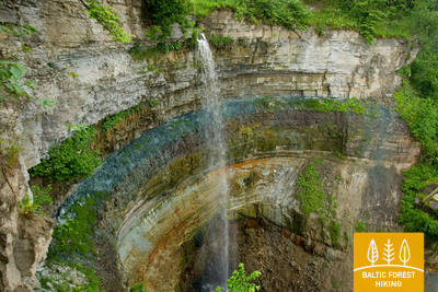
The Mārtiņsala Nature Trail
Ligikaudu 1 kilomeetri pikkune rada asub Mārtiņsalal ja tutvustab külastajatele Ventas Rumba juga. Pind koosneb kruusast (laius 1,60 meetrit) või laudteest (laius 95 cm) ilma läbisõidualadeta. Mõned osad on ligipääsetavad ratastoolis inimestele. Saadaval on kohandatud tualetid. Parkla on GPS-i juures: 56.970622, 21.980747. Mārtiņsala loodusrada asub Mežtaka raja kõrval.


93. päev. Kuldīga – Renda.
Venta jõe org ja Riežupe looduspark
Pärast pikka kivisilda, mis viib matkaja üle Venta jõe, kulgeb Metsa matkarada lühikest aega Venta jõe paremkaldal, mida liigestavad jäärakud, keerab seejärel Krasta tänavale ja Vetklīnika–Paleja teele, ning viib läbi Kalnmuiža metsa, Riežupe ja suure Renda metsa edasi Mazrenda küla poole. Maastik on siin tasane, sest tegemist on Kursa madalikul asuva Pieventa tasandikuga. Mazrendas kulgeb Metsa matkarada üle liiva-kruusakarjääri ning jõuab Kuldīga tänavat kaudu Renda külla. Selle päeva teekond kulgeb esiti Venta jõe oru looduskaitsealal ja hiljem Riežupe looduspargi territooriumil.
The Mārtiņsala Nature Trail
Ligikaudu 1 kilomeetri pikkune rada asub Mārtiņsalal ja tutvustab külastajatele Ventas Rumba juga. Pind koosneb kruusast (laius 1,60 meetrit) või laudteest (laius 95 cm) ilma läbisõidualadeta. Mõned osad on ligipääsetavad ratastoolis inimestele. Saadaval on kohandatud tualetid. Parkla on GPS-i juures: 56.970622, 21.980747. Mārtiņsala loodusrada asub Mežtaka raja kõrval.
95. päev. Sabile - Kandava.
Üks Kuramaa kaunimaid loodusparke
Metsa matkarada suundub Abava vasakkaldal kulgeva Kr. Barona tänava kaudu Sabilest välja. Väike rajake viib üle Abava ürgoru niitude ja läbi metsatukkade, kuni jõuab Rootsi Kaabu nimelise mäeni. Seejärel viib rada mööda väikest külateed Plosti–Pūcese teele (V1471), ületab Amula jõe ja naaseb Kalnmuižas Abava orgu, kust jõuab 6 km pärast Aizdzire mõisaparki. Nüüd keerab rada põhja suunas ja ületab kilomeetri pärast Abava jõe. Siin on Abava ürgorg oma täies ilus. Oru sügavus on ligi 40 meetrit. Pärast Kalamehe silda tõuseb Metsa matkarada Abava ürgoru põhjanõlvale, kus on arvukalt viinapuuistandusi. Läbi metsa loogeldes ristub matkarada Kandava–Renda teega (P130) ning saabub lõpuks piki Sabile tänavat Kandava linna. Teekond armsas väikelinnas kulgeb mööda Lauku, Ozola, Zīļu, Sabile ja Pilsi tänavaid, kuni jõuab sihtpunkti, Kandava ordulinnuse varemeteni. Kogu selle päeva teekond kulgeb Abava jõe ürgoru maastikukaitsealal.
The "Fairy Tale Forest" play trail
Kohviku "Plostkrogs" (GPS: 57.020908, 22.645401) juurde on loodud "Muinasjutumetsa" mängurada, kus on erinevad metsaloomade kujud, puumajakesed ja muud lastele mõeldud mängud. Raja pikkus on 1,6 km. On mõningaid takistusi, näiteks puujuured ja sissepääs läbi puumaja, kuid koos abilisega saavad ratastoolis inimesed uudistada "Muinasjutumetsa". See asub 1,2 km kaugusel Mežtaka rajast.
96. päev. Kandava - Jaunmokas.
Pūre – koht, kus valmistatakse šokolaadi
Piki Jelgava tänavat suundudes ületab Metsa matkarada vana kivisilla kaudu Abava jõe, kulgeb mõnda aega Daigonese tänaval, kust järgmised 5 km Daigone poole mööduvad kruusateel. Seejärel laskub matkarada mööda Dziļkalnsi–Pūre teed (V1464) Abava ürgorgu. Ületanud taas kord Abava jõe, keerab Metsa matkarada paremale ning siirdub mööda väikest teerada Pūre poole. Rada teeb kaare ümber Pūre mõisa ning kulgeb järgmised 5 km Galciemsi Zemeņu tänaval ja Pūre–Jaunsāti teel (C004). Piirkonna karjääridest kaevandatakse liiva ja kruusa. Galciemsis pöörab Metsa matkarada vasakule väiksele kruusateele (C003), mis 3,5 km pärast jõuab Jaunmoku–Jaunsāti teele (V1444). Veel 3 km hiljem ristub Metsa matkarada Riia–Ventspilsi maanteega ning saabub piki alleesid Jaunmoka lossi juurde. Jaunsāti poolt lossile lähenedes avanevad Metsa matkarajalt avarad vaated Spārnene ümbrusele, kus Austrumkursa lainjad tasandikud vahelduvad Vanema küngastikuga.
Čužu Marsh Nature Trail
Čužu raba ringrada tutvustab külastajatele ainulaadset metsikut võsa jõhvika esinemist, lubjarikast sood ja kunagist mineraalveekuurorti. Ligikaudu 1 km pikkune puidust laudteeosa koos ääristusega on kohandatud ratastoolis inimestele. Laudtee ühendub 0,5-kilomeetrise kruusateega, kus on spetsiaalselt projekteeritud parkla (GPS: 57.026431, 22.785473) ja kohandatud tualettruumid. Mõne piirkonna kalde tõttu võib vaja minna abi. Rada asub Mežtaka rajast ca 0,8 kilomeetri kaugusel.


Jaunmoku Castle Trail
Rada tutvustab külastajatele ligikaudu 1,5 kilomeetri pikkust mõisakompleksi ja parki. See on ligipääsetav ratastoolis inimestele. Raja katteks on asfalt, sillutis ja kruus. Parkla on GPS-i juures: 56.982423, 23.053098. Helistamisnupu abil saavad külastajad kutsuda töötajad, kes aitavad hoonesse siseneda ja seda seestpoolt vaadata. Rada asub Mežtaka raja kõrval. Saadaval on kohandatud tualetid.


97. päev. Jaunmokas - Tukums.
Kaunis Tukumsis
Jaunmoka lossi ümbruses paelub matkajaid Austrumkursa kõrgustikul asuvate Vanema mägede mitmekesine reljeef. Metsa matkarada laskub Bēru vesiveski juurde, seejärel tõuseb Vecmokase poole suundudes kolme kilomeetri jooksul 50 meetri võrra kõrgemale, et avada vaated lõunasse jäävale laiale Slocene orule. Pärast Vecmoka mõisaalleed ristub Metsa matkarada Tukumsi–Lazdasi teega (V1442), teeb looke ümber trobikonna talude ja möödub siis sirget metsateed pidi Sekļa järvest. Järve äärde viivad mitmed väiksed teekesed. Sveikuli puhkeküla lähedal jätkub rada ilusatel metsateedel, kuni jõuab Ozoliņi kalmistu juures Tukumsi–Kesterciemsi–Kolka teele (P131). Siin on Tukumsi linnapiir. Mööda Raudase, Kurzeme ja Melnezera tänavaid jõuab Metsa matkarada päeva lõpuks Päiksemäele (Saules kalns).
Jaunmoku Castle Trail
Rada tutvustab külastajatele ligikaudu 1,5 kilomeetri pikkust mõisakompleksi ja parki. See on ligipääsetav ratastoolis inimestele. Raja katteks on asfalt, sillutis ja kruus. Parkla on GPS-i juures: 56.982423, 23.053098. Helistamisnupu abil saavad külastajad kutsuda töötajad, kes aitavad hoonesse siseneda ja seda seestpoolt vaadata. Rada asub Mežtaka raja kõrval. Saadaval on kohandatud tualetid.
99. päev. Jāņukrogs – Bigauņciems.
Läbi Ķemeri rahvuspargi
Veidi aega kulgeb Metsa matkarada kultuurmaastikul, jõudes seejärel ilusasse okasmetsa, mööda Čaukciemsi asulast kuni keerab Antiņciemsi–Smārde teele, et siirduda Rohelise Luite (Zaļā kāpa) poole. Maastik on tasane, sest rada on jõudnud Piejūrase madalikul asuvale Engre lammile. Roheliselt Luitelt avanevad ulatuslikud vaated Rohesoole (Zaļais purvs) ja Nõiasoole (Raganu purvs). Väike metsatee viib mööda luitejalamit, kahes kohas viivad purded üle soolappide. Ķemerisse jõudes kulgeb Metsa matkarada piki Partizāna, Robeža, A. Upīša, Katedrāle ja E. Dārziņa tänavaid, mööda rahvuspargi külastuskeskusest ja Vēršupīte jõest, kuhu suubuvad sulfaadirikkad allikad. Rada ületab Tūristi tänava ning viib mööda Dūņu teed edasi Sloka järve poole. Seejärel jõuab rada Vēršupīte lodumetsa, mis on üks omalaadsemaid metsatüüpe kogu Kuramaale jääval Metsa matkaraja osal. Melnezersis keerab matkarada Ķemeri vanale maanteele ning saabub 2 km pärast Bigauņciemsi. Õige pea ületab Metsa matkarada Talsi maantee ning jõuab Liivi lahe rannikule, kus kohtub Ranniku matkarajaga. Kogu päeva teekond möödub Ķemeri rahvuspargis.
The Melnalkšņu Swamp Boardwalk
Ķemeru rahvuspargi külastuskeskuse lähedal asuv rada tutvustab külastajatele üht pargile iseloomulikku elupaika: märgasid metsi. 0,6-kilomeetrine laudtee rada on kõrgendatud puitvaiadele ja läbib kevadel üleujutavat soo. Laudtee on 1,2 meetrit lai ilma läbisõidualadeta, seega on oluline järgida ettenähtud sõidusuunda. See on ligipääsetav ratastoolis inimestele abiga. Raja alguses ja lõpus on katteks kruus ja asfalt. Saadaval on kohandatud tualettruum ja parkla on GPS-i 56.951980, 23.512914 juures. Rada asub Mežtaka raja lähedal ja seda taastatakse pärast 2024. aasta suvetormi.


100. päev. Bigauņciems - Dubulti.
Jūrmala ajaloolises kuurordis
Bigauņciemsi külast paistab kogu Jūrmala rannik justkui peopesal. Päeva esimene pool möödub Ķemeri rahvuspargi territooriumil. Jaunkemeri ja Dubulti vahelisel lõigul on võimalik kõndida Liivi lahe kõige laiemal liivarannal. Rada viib läbi Jūrmala ajaloolise kuurordi, mis on Läti pikim linn. Tasub arvestada, et ilusatel suvepäevadel on Jūrmala rannas väga palju rahvast.
Kupskalni Nature Trail
Rada ulatub pool kilomeetrit mööda Siliņupe jõe paremkallast ja viib Sloka-Talsi maanteelt mere äärde. See on osaliselt ligipääsetav abistamisega ratastoolis inimestele, kuna raja alguses võivad puujuured takistada. Raja edasine lõik (laiad laudteed läbipääsualadega) on ligipääsetav. Tualettruumi osaline juurdepääs on saadaval. Jalutuskäiku saab alustada lähedal asuvast tanklast (GPS: 56.992203, 23.522736).


Jūrmalas pilsētas pludmales
Jurmala linnarandadesse pääsevad funktsionaalse puudega inimesed, sealhulgas ratastoolis ja pensionärid. Jūrmalas on ratastoolidele 14 kohandatud juurdepääsupunkti merele: liin 36, Vienības prospekts (2 juurdepääsupunkti), Turaidas iela (2 juurdepääsupunkti), Pilsonu iela, Baznīcas iela, Kļavu iela, Līgatnes iela, Dzimtenes iela, Vēju iela iela, Atbalss iela, Kapteiņa Zolta iela ja Jaunķemeri tee. Need juurdepääsupunktid on loodud nii, et need sobiksid pinnast ja maastikku arvestades nii funktsionaalse puudega inimestele kui ka jalutuskäruga inimestele. Lisaks on neljas kohas – Vaivari, Kaugguri, Jaunķemeri ja Jaundubulti –, kus on saadaval laiendatud ja mugavamad riietuskabiinid.

101. päev. Dubulti - Lielupe - Bulduri.
Läti populaarseimad supelrannad
Ranniku matkaraja lõigul Dubulti ja Lielupe vahel paikneb Liivi lahe kõige laiem liivarand – oma lugematute rannakohvikute ja puhkamisvõimalustega on see Jūrmala kuurortlinna suurim väärtus ja tõmbenumber. Rannaäärsetes luitemetsades on tihe rajavõrgustik, mis sobib hästi jalutamiseks ja kepikõnni harrastamiseks. Lielupe ranna ja Jūrmala vabaõhumuuseumi vaheline matkaraja lõik kulgeb Ragakāpa looduspargi territooriumil. Buldurisse saab mugavalt tagasi kõndida mööda Bulduri avenüüd või 5. liini.
Jūrmalas pilsētas pludmales
Jurmala linnarandadesse pääsevad funktsionaalse puudega inimesed, sealhulgas ratastoolis ja pensionärid. Jūrmalas on ratastoolidele 14 kohandatud juurdepääsupunkti merele: liin 36, Vienības prospekts (2 juurdepääsupunkti), Turaidas iela (2 juurdepääsupunkti), Pilsonu iela, Baznīcas iela, Kļavu iela, Līgatnes iela, Dzimtenes iela, Vēju iela iela, Atbalss iela, Kapteiņa Zolta iela ja Jaunķemeri tee. Need juurdepääsupunktid on loodud nii, et need sobiksid pinnast ja maastikku arvestades nii funktsionaalse puudega inimestele kui ka jalutuskäruga inimestele. Lisaks on neljas kohas – Vaivari, Kaugguri, Jaunķemeri ja Jaundubulti –, kus on saadaval laiendatud ja mugavamad riietuskabiinid.
102. päev. Bulduri – Riia kesklinn.
Läbi metsade Riia poole
Ranniku matkaraja lõik kulgeb Jūrmalast läbi metsaste alade Riia suunas. Pärast Lielupe jõe silda lookleb rada läbi puithoonestusega Priedaine linnaosa, piki Lielupe jõe paremkallast ja keerab Bolderāja luite lõunaosa suunas. Põigates läbi Kleistu metsa ja kulgedes paralleelselt Lāčupe kalmistuga jätkub matkarada ajaloolises Pārdaugava linnaosas – mööda Buļļi ja Daugavgrīva tänavaid ning läbides Dzegužkalnsi. Möödudes Zunda kanalist ja Āgenskalnsi lahest jõuab matkaja Daugava jõeni, ületab vana kivisilla ja on matkapäeva lõpuks jõudnud Riia raekoja platsile.
Babīte Rhododendron Nursery
Rajatud on 1,9 kilomeetri pikkune rada, kuhu pääsevad ratastoolis inimesed ja käruga lapsevanemad. Raja katteks on asfalt. Olemas on määratud parkla (GPS: 56.962330, 23.952280) ja kohandatud tualettruum. Rada asub Jūrtaka rajast ca 2,7 kilomeetri kaugusel.
Daugavgrīva Nature Trail
Rada algab parklast (GPS: 57.036769, 24.018166), Valentīna Pikuļa tänava lähedalt ning viib üle Daugavgrīva soo luidete ja mereni. Mereäärne rajapind on asfalteeritud ning asfalteeritud lõik on ligipääsetav ratastooliga inimestele. Raja äärde on ehitatud linnuvaatlustorn, mille esimene korrus on ligipääsetav ratastoolis inimestele. Rada asub Daugavgrīvas mere rannikul asuvast Jūrtaka rajast ligikaudu 12,5 kilomeetri kaugusel.

Jūrmalas pilsētas pludmales
Jurmala linnarandadesse pääsevad funktsionaalse puudega inimesed, sealhulgas ratastoolis ja pensionärid. Jūrmalas on ratastoolidele 14 kohandatud juurdepääsupunkti merele: liin 36, Vienības prospekts (2 juurdepääsupunkti), Turaidas iela (2 juurdepääsupunkti), Pilsonu iela, Baznīcas iela, Kļavu iela, Līgatnes iela, Dzimtenes iela, Vēju iela iela, Atbalss iela, Kapteiņa Zolta iela ja Jaunķemeri tee. Need juurdepääsupunktid on loodud nii, et need sobiksid pinnast ja maastikku arvestades nii funktsionaalse puudega inimestele kui ka jalutuskäruga inimestele. Lisaks on neljas kohas – Vaivari, Kaugguri, Jaunķemeri ja Jaundubulti –, kus on saadaval laiendatud ja mugavamad riietuskabiinid.