


Baltic Coastal Hiking trail - Seaside resorts

Seaside resorts
Sandy beaches and light-filled pine forests
Klaipėda – Palanga – Lithuanian-Latvian border: 48 km, 2 or 3 days.
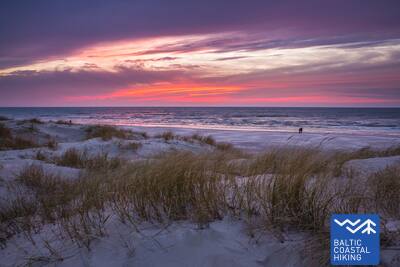
Klaipėda and Palanga are popular seaside cities with the atmosphere of a resort: with taverns, hotels, street-side cafes and musicians. Klaipėda is the only port city and the third largest city in Lithuania. The town of Šventoji located on the coast, where the Šventoji River runs into the Baltic Sea, is also a popular resort. Between Šventoji and Palanga, the Baltic Coastal Hiking Route leads through the Seaside Regional Park. The Park was established in order to protect the coastal and maritime landscape, biodiversity and local cultural heritage. The best-known tourist attraction on the coast is the Dutchman’s Cap, a bluff reaching more than 20 m that once served as a navigation mark for seafarers and fishermen. Historical heritage sites in the Park include authentic homesteads, as well as coastal defence batteries of the German army from World War II.
 Section 67. Klaipėda – Palanga.
Through the Seaside Regional Park
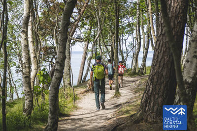
Following H. Manto Street, the Baltic Coastal Hiking Route leads out of the center of Klaipėda, traverses the Klaipėda Recreation Park, crosses a railway line by bridge and comes out onto the coast of the Baltic Sea in the southern part of Melnragė. The trail then winds through the dunes, for the protection of which wooden walkways have been installed, and continues on along a beautiful path through the coastal forest, following at a distance of about 10–20 m the pedestrian/cyclist lane through Antroji Melnragė to Giruliai. At Giruliai, it briefly comes out onto the beach, but from Kukuliškiai to the southern part of Karklė Village, the Baltic Coastal Hiking Route first passes along the incredibly beautiful coastline of the former Littorina Sea covered in primeval forest, and later, along a scenic bluff, created by the washing of waves; there are several viewing points along the way (including the Dutchman's Cap). From the Village of Karklė for the next 11 km to the Palanga Botanical Park, the Baltic Coastal Hiking Route leads across sandy and pebbly, occasionally rocky beaches. Through the coastal pathways in the western part of the Palanga Botanical Park, the trail leads over to Meilės avenue and then to the Palanga pedestrian bridge. Most of this section of the trail leads through the Seaside Regional Park.
 Section 68. Palanga – Latvia-Lithuania border (Šventoji).
Through the most popular seaside resorts of Lithuania
Having crossed the small Rąžė River, the Baltic Coastal Hiking Route follows the Labrytys pedestrian/runners’ lane and exits out onto the beach at Kontininkų Street. For the next 9 km to the old Šventoji Pier, the trail leads across the sandy, sea-washed beach. Then it loops around the mouth of the Šventoji River, leads through the resort town, and at the end of Kopų Street it crosses the Šventoji River over a hanging footbridge to come back out onto the beach. At the Žemaičių Alka parking lot, the Baltic Coastal Hiking Route makes another small loop “inland” and then follows the sandy beach to the Latvia-Lithuania border 3 km away.