


Section 61. Vormsi Island and Kihnu Island. Matsalu national park and the West Estonian islands.
Section 61. Vormsi Island and Kihnu Island.
Vormsi Island and Kihnu Island Get to know the fourth largest island in Estonia – Vormsi – by foot or by bicycle. Kihnu Island is the largest island in the Gulf of Riga and the seventh largest island in Estonia.
Vormsi Island
The island is an excellent place for a several days hiking trip enjoying the untouched and peaceful nature. Rare plants and bird species inhabit the coastal meadows, reeds and bays. Walking along the hiking trail which is 7 km long and crosses Rumpo Peninsula (No. 2, GPS: 58.970218, 23.265418) you will be able to see rare species of lichens and watch seabirds.
The Swedes founded Vormsi island in the 13th century. The Swedish coastal cultural heritage – red houses and interesting names of villages characteristic to Sweden – makes Vormsi one of the most original islands in the Baltic Sea. You can get a great overview about the Swedish lifestyle in the Sviby Country Life Museum (Sviby talumuuseum) (No. 3, GPS: 58.985012, 23.301669) – this is a completely reconstructed coastal Swedish country estate using photographs and memories of the Swedes who lived in the coastal areas. There are more than 330 different ring crosses in the Vormsi Cemetery (No. 4, GPS: 58.999338, 23.232949) making this the largest collection of this type of crosses in the world. The main historical and cultural monument of the island – the 14th century St. Olavi Church (Püha Olavi kirik) (No. 4, GPS: 58.999338, 23.232949) is unique in that it doesn’t have a tower. During the summer
you can purchase local handicrafts at Relbi Windmill (Rälby tuulik) (No. 5, GPS: 59.011983, 23.283609).
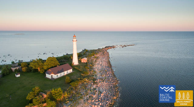
The Saxby seacoast with its limestone outcrops, allows you to see fossilized sea creatures that lived in the shallow tropical waters millions of years ago. The Saxby Lighthouse (Saxby tuletorn) is also located
here, offering a beautiful view of the sea and the island (No. 6, GPS: 59.027647, 23.117274). One of the most attractive places on Vormsi is the Huitbergi limestone hill in the sprucetree forest which is located in the centre of the island and the 3 km long Huitbergi Hiking Trail (Huitbergi matkarada) (No. 7, GPS: 58.993161,23.181986).
Kihnu Island
Its total area is 16.9 km², the island is 7 km long and up to 3.3 km wide. Kihnu is a great destination for one or two days of hiking or a cycling trip, as you can conveniently rent a bicycle on the island. Ferry traffic to Kihnu Port (No. 1, GPS: 58.14095, 24.01846.) takes place from Munalaiu Port. A great experience during the cold winter is walking to the island via the ice road.
The former seal hunter and fishermen island, with around 600 inhabitants currently, is eager to maintain its identity in spite of everything. The unique characteristics of the Kihnu cultural space, like the lifestyle of the community, the diverse cultural traditions, the kihnu language, music, national costumes and nature, are included in the UNESCO cultural heritage list. We can still meet Kihnu women dressed in long, striped skirts, carrying a wicker basket and riding a motorcycle.
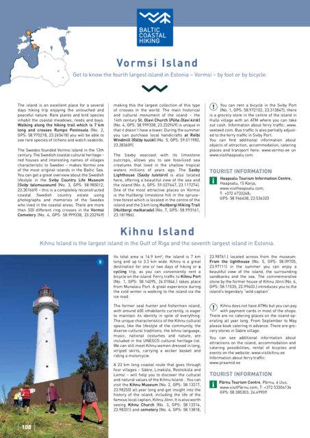
A 23 km long coastal route that goes through four villages – Sääre, Linaküla, Rootsiküla and Lemsi – will help you to discover the cultural and natural values of the Kihnu Island. You can visit the Kihnu Museum (No. 2, GPS: 58.13317, 23.98255) all year long and get insight into the history of the island, including the life of the famous local captain, Kihnu Jõnn. It is also worth seeing Kihnu Church (No. 3, GPS: 58.13314, 23.98331) and cemetery (No. 4, GPS: 58.13818, 23.98761.) located across from the museum. From the lighthouse (No. 5, GPS: 58.09705, 23.97111) in the summer you can enjoy a beautiful view of the island, the surrounding sandbanks and the sea. The commemorative stone by the former house of Kihnu Jõnn (No. 6, GPS: 58.11535, 23.99403.) introduces you to the island’s legendary “wild captain”.