


Baltic Coastal Hiking - Practical info
Coastal nature
- The coastal terrain is mostly flat, and for the most part, the Baltic Coastal Hiking Route is close to sea level.
- More distinctive terrain is at the Curonian Spit in Lithuania, where the height of the dunes reaches 50 m, and the highest peak is Vecekrugas dune with an altitude of 67 m above sea level. In order to stop sand from migrating, mountain pines Pinus mugo have been planted in many places and now cover a large part of the Curonian Spit.
- On the Baltic Coastal Hiking Route hikers can see various dune biotypes that are rare and protected at the European level, such as embryonic shifting dunes, white or foredunes, grey dunes and wooded seaside dunes.
- Seaside cliffs in Lithuania are located near the Karklė Village, reaching a height of 24 meters. In Latvia, seaside bluffs stretch along the coast from Strante to Ošvalki (12–16 m high) and near Staldzene (up to 8 m, with the height of the coastline reaching up to 29 m in the northern direction) and along the rocky seacoast in Vidzeme, while cliffs can be seen in Harju County situated near Tallinn in Estonia.
- The main obstacles on the Baltic Coastal Hiking Route are mouths of rivers (Šventoji River, Pape River, the Liepāja and Naval Port canals, Saka, Užava, Venta, Irbe and Roja rivers, Mērsrags Canal, Engure, Liepāja and Daugava rivers, Gauja, Salaca and Pärnu, etc) and ports. The Baltic Coastal Hiking Route bypasses these obstacles by the nearest pedestrian bridge or road.
- Smaller rivers and streams can be crossed on foot during low water season. Pedestrian bridges or plankways will often be found near the mouths of small rivers.
- The Baltic Sea coast does not feature dangerous natural elements. Severe storms are rare and usually occur during autumn and winter. During storms, waves crash against the coastal bluffs and they may collapse, therefore at such times the bluff sections of the trail must be bypassed inland.
- Sections of the Baltic coastal hiking trail beaches are not walkable during storms
- The dominant winds in Estonia, Latvia and Lithuania are west winds. These are significantly stronger on the Baltic Sea coast of Latvia, therefore if you are planning a one-day or multiday hike during heavy winds, the Baltic Coastal Hiking Route can be done in the opposite direction — with a tailwind.
- There are no high or low tides on the Baltic Coastal Hiking Route that would restrict or compromise the safety of walking along the coastline. Be careful during thunder and lightning — seek safe shelter.
- The coastline changes and the same place may look completely different every time you visit. The coastal bluffs are washed off during storms, the beaches change — sandy beaches may be replaced with pebbles or even rocks, while at other times the pebbles and rocks may be covered in sand washed out by the sea or blown in by the wind.
- The Baltic Coastal Hiking Route and its surrounding forests are excellent places to observe wildlife. The second largest animal in Europe — the moose — can be seen here. If you walk quietly, you may be able to see roe deer, red deer, foxes, hares, martens, otters, red squirrels, and hedgehogs in the coastal forests. You may even see footprints left by wolves and lynx.
- The coast, the wetlands, marshes, shallow coastal lakes and seaside meadows are a bird watcher’s paradise. Mērsrags, Cape Kolka, Liepāja and Pape lakes, the Nemunas Delta and Vente Cape are excellent birdwatching locations during spring and autumn migration.
- On the coast you will see various plant species, the most easily recognisable being Sea-Rocket, Sea Sandwort, Lyme grass, European Marram Grass, the purple Marram, the Petasites spurius, Breckland Thyme, Goldmoss Stonecrop, Beach Pea, dark-red Helleborine, Meadow Pasqueflower, Sand pink. The latter four are protected species.
- Lithuanians, Latvians and Estonians enjoy going to the coastal woods to gather the natural goods of the forest — mushrooms (chanterelles, russulas, boletus, etc.) and wild berries (bilberries, lingonberries, raspberries; in wet forests and marshes — cloudberries and cranberries). Wild plants are used for preparing herbal teas.
Trail surface
- In Lithuania, the Baltic Coastal Hiking Route mainly goes along sandy beaches, sidewalks and trails. In some places, the trail goes along asphalt and gravel roads. For short distances, the trail goes on dirt roads, wooden paths, seaside meadows and pebble beaches.
- In Latvia, the Baltic Coastal Hiking Route mainly goes along sandy beaches, in some places, rocky beaches, and for short stretches, through coastal meadows. There are well-trodden trails and small roads in the seaside forests. In some areas, the sand may be soft, which makes walking difficult.
- In Estonia, the Baltic Coastal Hiking Route goes along the very seashore for around 100 km, mainly between Haapsalu and Tallinn. In other places, crossing the coastline becomes difficult as it is shaped by numerous capes, peninsulas, wetlands with reeds, floodplains, lagoons and shallow coves, which is why the remaining distance of around 500 km has to be covered via seaside trails, roads and along motor roads.
- In cities and populated areas, the Baltic Coastal Hiking Route goes along pedestrian sidewalks.
The seasons in the Baltic States
The route can be done throughout the year. Each season offers certain benefits, as well as disadvantages:
In summer (June-August) is tourist season in Lithuania, Latvia and Estonia, so there are more people on the beach than during other seasons, and therefore accommodation near the seaside may be booked for quite some time ahead. In summer, the water temperature in the sea can reach +20°C, max +26°C, so it is possible to go swimming. However, depending on the direction of the wind, even on the hottest summer day, the water in the sea could be icy cold. The sandy sections of the beach are nice to walk barefoot, easily crossing small rivers and streams flowing into the sea. There may also be longer periods of rain and lower temperatures (~+13 °C), so it is definitely a good
idea to check the weather report ahead of time.
In autumn (September - November) nature becomes more colourful with the leaves of trees turning, and the forest full of mushrooms, berries and nuts. Birds migrate. There are storms, during which amber is washed out from the sea. Some accommodation and catering establishments may be closed at this time, so book ahead.
The route may also be done in winter (December — February), however, hikers must take into consideration that some services will not be available during this time. In case of prolonged periods of ice and snow, some sections, such as the Kurzeme (Courland) coast of the Gulf of Riga, can be done on skis. However, lasting snow cover is quite rare on the coast of the Baltic Sea, occurring only once or twice a decade. During cold winters, various ice formations and ice ridges can be observed. During autumn and winter, especially when snow is melting, the small rivers that can be easily crossed on foot during the summer will have a much higher water level. Hikers will thus need to find the nearest footbridge or road crossing the river.
During the spring (March — May) hikers can witness nature awakening with the colour green taking over, lilacs perfuming the air and birds returning. Small rivers and streams that are easily crossed on foot during the summer may run high waters in spring, meaning hikers will have to search for the nearest bridge. The range of accommodation and catering services in spring is still limited. In spring, it is usually colder on the coast than further inland, as the sea has cooled during the winter and it takes longer for it to warm up.
Sections of the Baltic coastal hiking trail beaches are not walkable during storms
If you plan to go hiking in WINTER:
- Do not step on bodies of water covered by ice - rivers, streams, lakes, swamps or the sea. The ice can be fragile and there is always a possibility to break in, even if the ice layer is thick in most places! To cross rivers in winter that flow into the sea, you have to go to the nearest bridge or crossing. In this case, additional distance must be taken into account.
- If the air temperature is low, it is not advisable to hike in areas where there are long distances between service providers or public buildings, as prolonged exposure to low temperatures can lead to body hypothermia.
- On winter hikes, it is recommended not to rely on one set of clothing, but to bring extra clothing that can be worn if it gets cold or if the existing clothing gets wet.
- When the trails are covered with snow, it is advisable to use footwear gaiters, which will protect your feet from moisture. Also take into account that it is more difficult to walk on snow and it will take more time.
- It gets dark earlier in the winter, so hikes have to be planned shorter and should be started with the first rays of light, otherwise you have to take into account that part of the section will have to be covered in the dark.
- Take a flash-light with you! This will be useful if there are delays and it is necessary to clear parts of the route in the dark, as well as in extreme cases when it could be necessary to report your location to rescuers.
- Slopes of river valleys, ravines, steep banks and other forms of terrain, as well as any other place of the route can be slippery in winter! Be aware of the chance of falling and getting injured!
- At low temperatures, especially during stronger winds, it is easy to get frostbite.
- Take lighters or other ways to light a fire with you on the hike so that you can warm up or dry your clothes if necessary.
- You will also be able to warm up by hot tea or food, so for this purpose we recommend using a thermos suitable for low temperatures or bringing a hiking stove to prepare a hot drink / food.
- For safety reasons, it would be recommended not to go on winter hikes alone, but at least in pairs.
- However, if you have decided to go hiking alone, be sure to inform your family and friends about your planned route and possibilities to contact you to make sure everything is in order.
- Be sure to bring a phone and an extra rechargeable battery. Remember that batteries discharge faster in cold weather. Keep them as close as possible to yourself – near something warm, which will prolong their service life.
- In winter (and during the off-season) many service providers have stopped working, so the hike needs to be planned more carefully by calling the necessary service providers in advance and making sure of their working hours.
- Snow is cleared from the route only in populated areas.
Services and infrastructure
The availability of accommodation, including camp sites, differs by section of the Baltic Coastal Hiking Route. Information on accommodation is provided in the description of each section. It includes the name of the accommodation establishment, GPS coordinates and phone number. It is recommended to book accommodation in advance as establishments may be fully-booked during the summer (June–August). In turn, in winter some accommodation establishments may be closed for the season. On the map, accommodations are marked with  , while campsites are represented by the symbol
  .
.
 Availability of catering establishments differs by section of the trail. There are no such services available on some sections of the trail. Keep in mind that some places only work during the summer or at specific times, so check ahead by telephone before visiting.
 More than 85 free public rest areas have been created along the Baltic Coastal Hiking Route. These can be equipped with shelters, picnic tables, benches, rubbish bins, firepits and toilets (not available everywhere). Rest spots are also available next to accommodation sites, however, permission
to use them has to be obtained from the owner. In the descriptions of the sections, signs show if tents , bonfires  , and grills are permitted.
 Stores are available in populated areas. Keep in mind that there are some sections of the Baltic Coastal Hiking trail where stores are not available for one or more days of hiking. This information is provided in the description of each section.
 To find out the current weather conditions in trails, more than 50 live cameras located on the trail routes have been added to the maps of both trails. Cameras are located on beaches, ports, populated areas, near tourist accommodation, in cities. Coating – on average, one camera for every 40km – allows you to judge the weather conditions and choose the most suitable equipment for the day of hiking. - open the map, mark the option "Webcam" to see all the cameras located on the trail, click on the link to open the camera on the section of the trail you are interested in, evaluate the weather conditions and choose what to take with you on the hike - raincoat or suntan cream!
Public transport is available in direct proximity or close by the Baltic Coastal Hiking trail (mostly buses, sometimes trains), however, timetables should be checked in advance.
For Lithuania, visit www.autobusubilietai.lt/ (buses) and www.traukiniobilietas.lt (trains).
For Latvia, visit www.autoosta.lv (buses), www.pv.lv (trains), and www.1188.lv (public transport).
For Estonia, visit www.peatus.ee (buses), www.tpilet.ee (buses), and www.elron.ee (trains).
City public transport is accessible in Klaipėda, Liepāja, Ventspils, Jūrmala, Riga, Pärnu, Haapsalu and Tallinn. You can get to the Estonian islands by ferry: Kihnu, Vormsi (www.veeteed.com), Saaremaa, Hiiumaa (www.praamid.ee). Pre-booking is required to Osmussaare (www.osmussaar.ee - in Estonian, +372 5866 9980 Osmussaare Reisid).
Doctor’s offices, medical practices and pharmacies are available in the cities and the more populated areas. In case of an emergency situation: 112!
How to complete Baltic Coastal Hiking route?
- The Baltic Coastal Hiking trail is divided into # 73 separate sections which are described in the guidebook and website.
- The sections have been numbered in the order of their creation. From Nida to the Lithuanian/Latvian border go from # 64 to 73. From the Lithuanian/Latvian border to Riga go from # 1 to 23. From Riga to Latvian/Estonian border go from # 24 to 30. From Latvian/Estonian border to Tallinn go from # 31 to 60. On some of the Estonian islands, you can find sections # 61-63.
- Each section can be done as a stand-alone route. In the guidebook and website,
 marks the recommended starting and end point of each section. By linking several sections according to the time available to you, you can plan a route for several weeks or even months.
 - The Baltic Coastal Hiking trail can be started at any point and done in either direction. The trail is marked in both directions.
- Based on interests and preferences, some sections of the Baltic Coastal Hiking trail can be travelled using public transport rather than on foot. With some accommodation hosts it is possible to arrange transport services or sending luggage ahead to the next stop.
- Descriptions of each section of the Baltic Coastal Hiking trail can be printed and their GPX files can be downloaded from www.baltictrails.eu/en/coastal/itinerary.
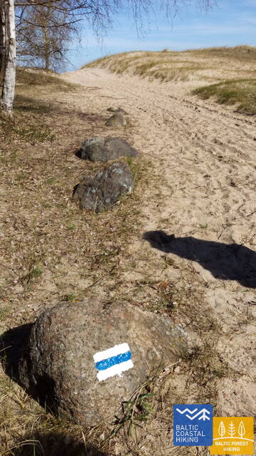
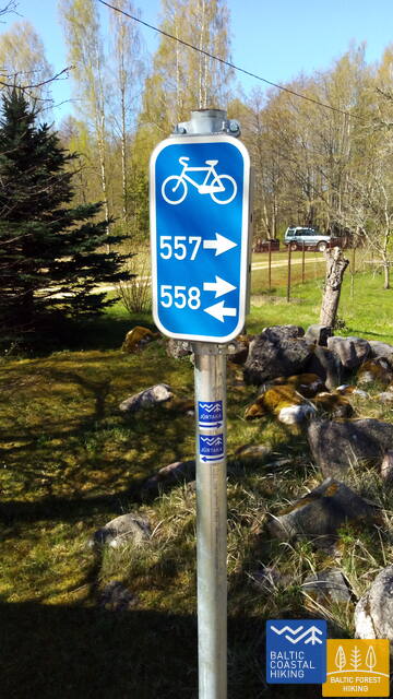
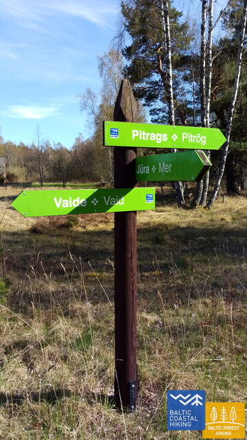
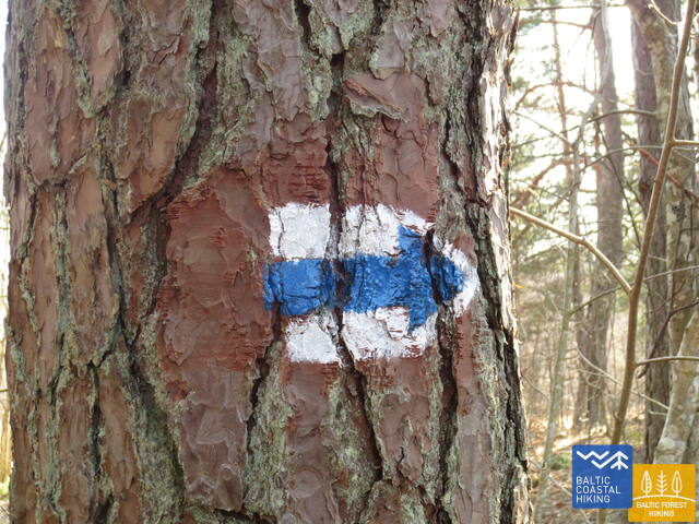
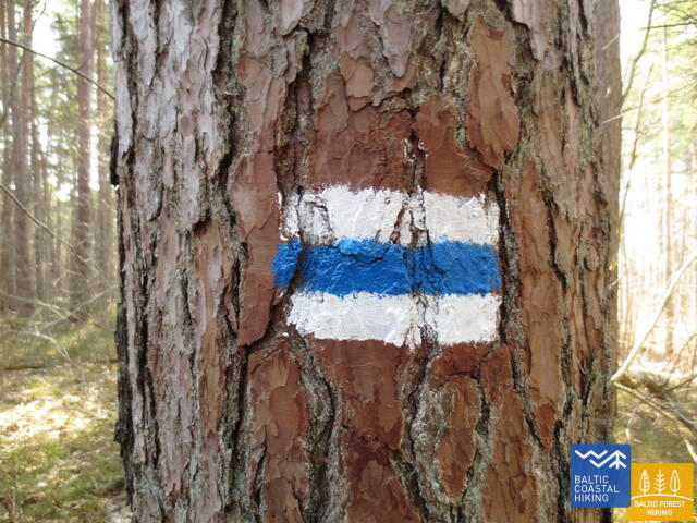
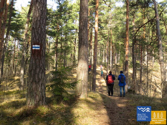
- In nature the Baltic Coastal Hiking trail is easily followed by the markings (white-blue-white) on trees and other objects. In populated areas, the trail is marked with Baltic Coastal Hiking stickers on signposts and other objects. In the Curonian Spit, Slītere and Ķemeri National Parks, the Baltic Coastal Hiking trail occasionally coincides with other pedestrian and cycling routes which are also marked with coloured markings on trees and other objects. Be careful to follow the Baltic Coastal Hiking trail markings here and use the GPX files.
- Information posters have been placed at some spots along the Baltic Coastal Hiking trail, and these will help you navigate the surroundings.
- On the Curonian Spit the Baltic Coastal Hiking trail follows single-track trails along the Curonian Lagoon, while on the Baltic Sea side it mostly runs along the sandy beach or seaside forest trails. The branch of the Baltic Coastal Hiking trail on Rusnė Island runs along polder dikes, small gravel and paved roads. On the eastern coast of the Curonian Lagoon the route follows small coastal roads, sometimes trails.
- Along the coast of the Baltic Sea in Kurzeme, the Baltic Coastal Hiking trail mostly runs along the shore and its sandy beaches. Occasionally may also follow small forest roads. In cities, the Baltic Coastal Hiking trail follows pedestrian lanes. The coast of the Gulf of Riga is diverse, therefore the Baltic Coastal Hiking trail runs along sandy beaches, which sometimes turn into a rocky shoreline, and briefly also — coastal meadows. As it approaches Riga, the trail follows small forest roads and pedestrian lanes.
- In Estonia, the Baltic Coastal Hiking Route goes along the very seashore for around 100 km, mainly between Haapsalu and Tallinn. In other places, crossing the coastline becomes difficult as it is shaped by numerous capes, peninsulas, wetlands with reeds, floodplains, lagoons and shallow coves, which is why the remaining distance of around 500 km has to be covered via seaside trails, roads and along motor roads.
- In places, where the Baltic Coastal Hiking Route goes along the beach and continues straight forward for a long distance, it is not marked. Along the shore of the Great Sea (the Kurzeme coast of the Baltic Sea) and the Little Sea (the Kurzeme coast of the Gulf of Riga), big wooden signs are placed in the dunes near populated areas providing information about the specific populated area, as well as indicating the distance to the closest village in both directions.
How to navigate the Baltic Coastal Hiking trail if you leave your vehicle at the starting point?
- It is possible to arrange transport services with the host of your accommodation in advance. Namely, the host can take you back to the starting point, drive out to meet you or transport your luggage if necessary.
- Hikers can also organise their own logistics by taking one car to the end point and leaving the other at the starting point. Having reached the end point, you can then drive back to get the other car from the starting point. Where available, public transport can also be used for this purpose.
-
If you are doing the Baltic Coastal Hiking trail in full, you will have to plan any use of public transport within one country or cross-border transport in advance. Buses run regularly between Tallinn and Riga and between Riga and Klaipėda. A bus can be taken from Klaipėda to the Curonian Spit and Nida at the Lithuanian–Russian border. Two ferries run between Klaipėda and the Curonian Spit.
Information about types of surfaces can be found here: baltictrails.eu/en/coastal/surfaces
The information compiled in this website and the content of the GPX files correspond to the situation in 2020 and 2021. When using the GPX files, keep in mind that in forests, cities and populated areas, by bluffs, etc., the itinerary of the Forest Trail is/may be shifted (there might be an error).
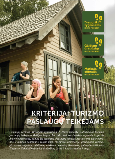
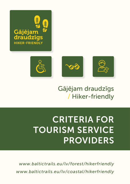
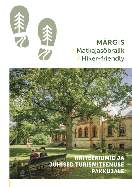
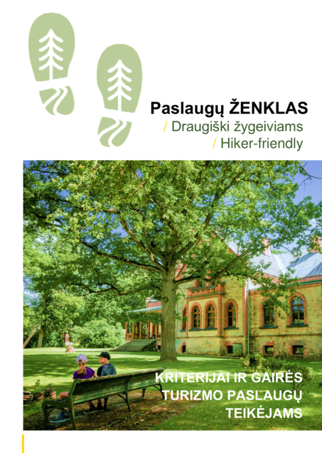
Hiker-friendly
The “Hiker-Friendly” sign is available to any service providers for tourists in the Baltic States that want to be “friendly” toward hikers and to offer the relevant services to the target audience. The label is not linked to any specific pathway or route. The “Hiker-Friendly” criteria are guidelines for service providers. Some of them are mandatory, while others are recommended. A company which wants to get the sign must satisfy at least 75% of the mandatory criteria.
More information below:
Hiker-Friendly


Useful advice
Money and ID Documents
- It is recommended that you take some cash (EUR) with you on the trip, as in some places credit cards are not accepted and ATMs are not available.
- When crossing a country border or when you are near a border, you have to carry identity documents valid for travel.
Equipment
- When going through stony and rocky sections, you should avail yourself of closed footwear, while in places with an overgrown coast, water-resistant footwear will come in handy. Water and wind resistant clothing will also prove useful.
- Bringing a first-aid kit, band-aids, especially for novice hikers, is certainly recommended.
- You will need a power bank for your phone as there are several long sections where it is not possible to charge electrical devices.
Tents and Campfires
- Tents can be set up and campfires can be lit:
- In Lithuania: only in specially designated areas. It is prohibited to pitch tents and burn bonfires on the beach.
- In Latvia:
- in specially protected conservation areas (SPCA
 ) like national parks, nature parks and nature reserves, tents and campfires are allowed only in public rest areas designed for this purpose;
 - in locations outside SPCAs, it is allowed to set up tents and make campfires on the beach (in the territory between the edge of the water up to the first dune where the terrestrial vegetation starts), except when it is prohibited by the laws of the local municipality. You can learn these regulations in the nearest
 .
.
- in specially protected conservation areas (SPCA
- In Estonia: camping and campfires are allowed in specially prepared and designated places only. Camping is prohibited on the beach.
- If there is no firewood, you will have to collect fallen, dry wood. You must make sure the fire is completely out when you are done.
- Use a portable grill only in prepared and designated campfire sites.
- Bonfires are prohibited during periods of high-risk for wildfires, usually — in summer. Information about the level of fire hazard in Lithuania is available at: www.emhi.ee; Latvia is available at: www.lvgmc.lv; in Lithuania: www.meteo.lt/lt/misku-gaisringumo-klases-prognozes. Make sure that going out into the forest is not prohibited based on the level of fire hazard (in Latvia, check www.vmd.gov.lv, in Lithuania: www.vivmu.lt). On the Curonian Spit, Lithuania, in places where bonfires are permitted there are information posters with the phone numbers to call in case of a fire.
- In case of fire, call 112 in Latvia. In Estonia, call the Rescue Board information telephone 1524 or the nearest State Forest Management Centre (RMK) information point www.rmk.ee .
-
In Lithuania, Latvia and Estonia, in accordance with safety regulations, it is permitted to use a portable Primus stove for making food, coffee or tea. Gas cylinders can be purchased at the following stores near the Baltic Coastal Hiking route (contact in advance):
Rīga
Shop “Gandrs”, Rīga, Kalnciema street 28, +371 25445223
Shopping Center "Alfa", TP "Alfa", Brīvības gatve 372, +371 22018137
Tallinn
Tools market, Pärnu mnt 238, Tallinn, +372 53440330
“MatkaSport store”, Järve shopping Center, Pärnu mnt 234, +372 6813140
Safety And Communication
- In case of queries about the Baltic Coastal Hiking Route, contact information is available at www.baltictrails.eu and the local .
- Network coverage may not be available in some places along the Baltic Coastal Hiking trail.
- Most accommodation and catering establishments offer Wi-Fi.
- The coastal cliffs, bluffs and outcrops are made of unstable sediments. They are prone to landslides and landfall.
- In times of strong winds, it is not safe to approach places where the bluffs are washed against by waves; they should be bypassed.
- In warm weather, bug spray (against mosquitos/ticks) may be useful. There can be ticks in the grass and bushes.
- There are no poisonous or dangerous plants and animals (incl. jellyfish) in the salt and fresh waters of the Baltics. The common European viper is the only poisonous snake found in the Baltic States. It will usually not attack unless threatened. The common European viper lives in clearings overgrown with grass and bushes, as well as on the edges of the forest, in swamps, sparse pine forests where heathers and forest berries grow. The snakes may sunbathe out on trails.
- So-called “phosphorus” may be washed onto the seashore: these are the remains of Soviet chemical weapons which look like amber and are very dangerous. You must notify the police about them by calling: 110 or 112.
- Former military objects which are not accessible to visitors may be unsafe.
- To reach the police, call 112.
- Bears do not attack people - to scare away bears, you have to make noise (talk, sing).
Eco-friendly Travelling
- The symbol of specially protected conservation areas and nature objects is

- It is perfectly safe to drink tap water in Lithuania, Latvia and Estonia. It is recommended to use a refillable water bottle.
- While out in nature, behave quietly so as not to disturb the animals living there or other travellers and holidaymakers.
- Try to buy products with less packaging and bring your rubbish with you to the closest bin.
- Please pay attention to environment protection notices in SPCAs. In Estonia, also see the principles of freedom to roam loodusegakoos.ee/rules-of-conduct/freedom-to-roam
- The relevant rules of conduct must be adhered to while inside specially protected nature areas. More information available here: www.daba.gov.lv. Tips for eco-friendly travelling through protected nature areas are available.
Travelling with a dog
- If you have a dog with you, make sure it does not disturb nesting and resting birds and wild animals and that it does not harm baby seals in the spring. Bringing a dog may be prohibited at city beaches. In SPCAs, a dog must be on a leash.
- Each municipality has its own rules as to where dogs are permitted — on or off-leash. These rules may change over time, so it is recommended to check with each municipality ahead of time, by calling the local information center.
- In most cities and villages dogs must be on-leash when outside any confined area. The dog owner must ensure that their dog will not cause harm or damages to other people, animals or property.
- It is prohibited to bring dogs into children’s playgrounds, sports grounds and entertainment sites, specially established beaches and anywhere where such a prohibition is indicated by signs (with the exception of guide-dogs).
- In the rest spots noted in the guidebook, dogs must be kept on-leash.
- On ferries, dogs must be on-leash and muzzled.
- On the beach and surrounding areas, the dog must be on a leash and the owner must make sure that their dog doesn’t disturb birds’ nests, resting birds and other wildlife, including seals and seal pups on the beach.
- Beaches near populated areas have specially designated areas where animals are permitted. It is prohibited to take dogs to certain areas of the beach, it is advisable to bypass these in summer. Locations of dog-friendly beaches in:
Nida (GPS: 55.32511, 20.99223),
Juodkrantė (GPS: 55.54094, 21.09848),
Smiltynė (GPS: 55.71176, 21.09525),
Nemirseta (GPS: 55.86966, 21.06346),
Ventspils (GPS: 57.378839, 21.517392 to GPS: 57.382166, 21.520697),
Liepāja (GPS: 56.509326, 20.990846 to GPS: 56.520494, 20.9826140).
NaviCup

NaviCup mobile app takes hiking experience to a new level. Download: Google Play or App Store.
More information available on the NaviCup website.
The information and GPX files are up to date for 2020-2021. When using GPX files, take into consideration that in forests, cities and populated areas, near bluffs and elsewhere, there may be a certain margin of error from the actual route of the Baltic Coastal Hiking trail.