


Baltic Coastal Hiking trail - Matsalu

Matsalu national park and the West Estonian islands
Matsalu Bay, Saaremaa, Muhu, Hiiumaa, Vormsi islands
Virtsu – Puise: 100 km, Day 42 – Day 46
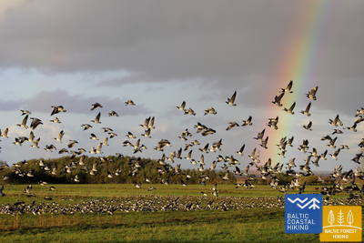
The Baltic Coastal Hiking Route leads you through Matsalu National Park, which is the largest wetland in Northern Europe. It includes the shallow Matsalu Bay, the lower reaches of the Kasari River, littoral reeds, the overflowing floodplains of the Kasari, coastal pastures, forest meadows and around 50 sea islands. Matsalu National Park has nature trails and 7 birdwatching towers. The territory is crossed by the migration routes for birds travelling from the White Sea to the Baltic Sea. Here you can see deer, elk, foxes and other animals. The Baltic Coastal Hiking Route takes gravelled country roads and goes through Lihula town. By taking a ferry from the port of Virtsu or Rohuküla, you can get to the islands of the West Estonian archipelago: Saaremaa, Vormsi and Hiiumaa.
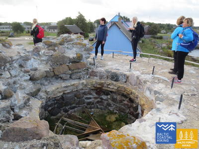
 Section 42. Virtsu - Kuke.
Through Orchid and Juniper Fields
The Baltic Coastal Hiking Route snakes through Virtsu village after which it goes along a motorway for 3 km and then it takes a 90 degree turn towards the northwest, meandering through a wind farm and a former Soviet military airfield, in the surroundings of which orchids bloom beautifully during the summertime. Next, you will see the Suur Väin Strait and beautiful juniper fields. Before reaching the Jõeoja Brook, for ~ 1 km the road goes along the upper part of the ancient seacoast.
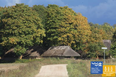
 Section 43. Kuke - Meelva.
Along the Islands of the Baltic Ice Lake
The Baltic Coastal Hiking Route goes along small country roads where individual farmsteads and cultivated fields appear in sight. When approaching Matsalu Bay, you will see wetlands: overgrown lakes that have once separated from the sea as bays and coastal meadows ruined by grazing cattle. Near Mõisaküla (the beginning of Matsalu National Park) and Salevere villages, distinct hillocks appear that used to be islands in the Baltic Ice Lake more than 10 000 years ago.
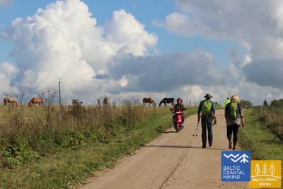
Section 44. Meelva - Penijõe.
Following the Trail of the Livonian Chronicle of Henry
For this day, the start and end point for the current section of the Baltic Coastal Hiking Route are located in Matsalu National Park, but the major part of it lies outside the park’s territory. Travellers will have their attention captured by the small villages and country roads with beautiful individual farmsteads and rural landscapes with cows and sheep grazing in the grass, as well as Lihula, the first see of the Bishopric of Saare-Lääne (Ösel–Wiek), which is indirectly mentioned in the Livonian Chronicle of Henry in relation to the events of 1211 when Abbot Theoderich of the Daugavgrīva (near Riga) monastery was ordained as the first Bishop of Estonia.
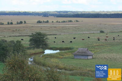
Section 45. Penijõe - Laiküla.
Around the Largest Wetland in Northern Europe
The Baltic Coastal Hiking Route takes you on a stroll around the Kasari River delta where it flows into Matsalu Bay and where one of the largest wetlands in Northern Europe has taken shape with large reedy fields, coastal meadows, oxbow lakes and water from the shallow bay, being a notable nesting and stopover site for migratory birds. The itinerary mainly leads through farmland landscapes and small villages. In the surroundings of Kirbla, you can see an elevation of the terrain, which is a former Baltic Ice Lake Island with its ancient coast in the north.
Section 46. Haeska - Puise.
Observing Birds and Nature in Matsalu National Park
One of the most beautiful sections of the Baltic Coastal Hiking Route in Matsalu National Park, which leads through the agricultural lands and coastal meadows located near Matsalu Bay, where thousands of migrating cranes and geese gather in autumn. There are excellent birdwatching sites with towers near Haeska village (coastal meadows, shallow coves, small islets, cattle pastures) and at Cape Puise (coastal meadows with pastures, shoals). The most panoramic views of the sea and strings of islands can be seen in the surroundings of Põgari-Sassi and Puise nina.
Section 61. Vormsi Island and Kihnu Island.
Get to know the fourth largest island in Estonia – Vormsi – by foot or by bicycle. Kihnu Island is the largest island in the Gulf of Riga and the seventh largest island in Estonia.
Vormsi Island
The island is an excellent place for a several days hiking trip enjoying the untouched and peaceful nature. Rare plants and bird species inhabit the coastal meadows, reeds and bays. Walking along the hiking trail which is 7 km long and crosses Rumpo Peninsula (No. 2, GPS: 58.970218, 23.265418) you will be able to see rare species of lichens and watch seabirds.
The Swedes founded Vormsi island in the 13th century. The Swedish coastal cultural heritage – red houses and interesting names of villages characteristic to Sweden – makes Vormsi one of the most original islands in the Baltic Sea. You can get a great overview about the Swedish lifestyle in the Sviby Country Life Museum (Sviby talumuuseum) (No. 3, GPS: 58.985012, 23.301669) – this is a completely reconstructed coastal Swedish country estate using photographs and memories of the Swedes who lived in the coastal areas. There are more than 330 different ring crosses in the Vormsi Cemetery (No. 4, GPS: 58.999338, 23.232949) making this the largest collection of this type of crosses in the world. The main historical and cultural monument of the island – the 14th century St. Olavi Church (Püha Olavi kirik) (No. 4, GPS: 58.999338, 23.232949) is unique in that it doesn’t have a tower. During the summer
you can purchase local handicrafts at Relbi Windmill (Rälby tuulik) (No. 5, GPS: 59.011983, 23.283609).
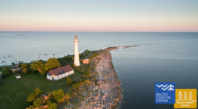
The Saxby seacoast with its limestone outcrops, allows you to see fossilized sea creatures that lived in the shallow tropical waters millions of years ago. The Saxby Lighthouse (Saxby tuletorn) is also located
here, offering a beautiful view of the sea and the island (No. 6, GPS: 59.027647, 23.117274). One of the most attractive places on Vormsi is the Huitbergi limestone hill in the sprucetree forest which is located in the centre of the island and the 3 km long Huitbergi Hiking Trail (Huitbergi matkarada) (No. 7, GPS: 58.993161,23.181986).
Kihnu Island
Its total area is 16.9 km², the island is 7 km long and up to 3.3 km wide. Kihnu is a great destination for one or two days of hiking or a cycling trip, as you can conveniently rent a bicycle on the island. Ferry traffic to Kihnu Port (No. 1, GPS: 58.14095, 24.01846.) takes place from Munalaiu Port. A great experience during the cold winter is walking to the island via the ice road.
The former seal hunter and fishermen island, with around 600 inhabitants currently, is eager to maintain its identity in spite of everything. The unique characteristics of the Kihnu cultural space, like the lifestyle of the community, the diverse cultural traditions, the kihnu language, music, national costumes and nature, are included in the UNESCO cultural heritage list. We can still meet Kihnu women dressed in long, striped skirts, carrying a wicker basket and riding a motorcycle.
A 23 km long coastal route that goes through four villages – Sääre, Linaküla, Rootsiküla and Lemsi – will help you to discover the cultural and natural values of the Kihnu Island. You can visit the Kihnu Museum (No. 2, GPS: 58.13317, 23.98255) all year long and get insight into the history of the island, including the life of the famous local captain, Kihnu Jõnn. It is also worth seeing Kihnu Church (No. 3, GPS: 58.13314, 23.98331) and cemetery (No. 4, GPS: 58.13818, 23.98761.) located across from the museum. From the lighthouse (No. 5, GPS: 58.09705, 23.97111) in the summer you can enjoy a beautiful view of the island, the surrounding sandbanks and the sea. The commemorative stone by the former house of Kihnu Jõnn (No. 6, GPS: 58.11535, 23.99403.) introduces you to the island’s legendary “wild captain”.
Section 62. Hiiumaa Island.
Only a one hour trip by ferry from the Estonian continental part, there is an island where time passes differently.
The pleasant humour of the locals adds some zest to the peaceful lifestyle. Hiiumaa appeared 455 million years ago due to a meteorite explosion and is one of the oldest islands in the world.
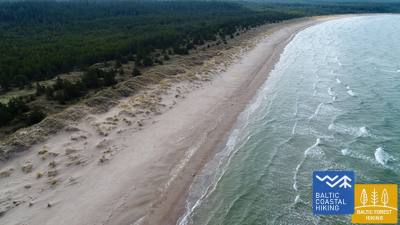
Estonia’s second largest island’s characteristic wild nature is perfect for the lovers of hiking and cyclists. Hiiumaa is like one big SPA – lots of sun, the peaceful sounds of the sea, tiny pebbles on the beach massaging your feet and the salty sea water healing both the body and soul. Long sandy beaches are a great place for active recreation. Windy and gusty Ristna is a real surfer’s paradise. You can take a romantic walk on the Sääretirp Horn where sheep graze leisurely among the junipers of Kassari peninsula.
The lighthouses are the main attractions on this island. Kõpu is one of the three oldest lighthouses in the world that is still operating. The office of the world-renowned Gustav Eiffel designed the Ristna and Tahkuna lighthouses. Climbing to the top of the lighthouse, there is a wonderful view of most forested part of Estonia.
On Hiiumaa the boats are still made of wood and the men from steel. A trip on the sailing ship “Lisette” or the “Hiiu Ingel” is also worth experiencing. During the cold winter months one can use Europe’s longest 26 km long ice road, which connects the island with the continental part of Estonia, instead of a ferry. The island’s capital, Kärdla, is one of the greenest towns in Estonia. Here you can escape from the city noise and spend your leisure time in a pleasant coastal holiday house or local pub enjoying Hiiu beer and smoked fish.
Section 63. Saaremaa, Muhu and Ruhnu Islands.
The largest island in Estonia, Saaremaa, is surrounded by thousands of smaller islands, thus its name is well deserved.
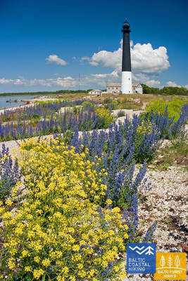
When you reach Muhu Island after a half hour trip by ferry, you get the feeling that time has stopped – nature and traditions have not changed over the course of time. Muhu island is renowned for its beautiful handicrafts. The blooming island in summer has inspired bright colours and flower embroidery. More than 25 protected orchids species grow here. The outcrops and precipice of the Northern beaches of Saaremaa allows you to see Silurian period fossils formed almost 440 million years ago.
The small strait dam connecting Muhu island and Saaremaa is a popular place for birdwatchers. Thousands of water birds and sparrow species fly across this place during the birds’ migration. The western part of Saaremaa offers you adventures in Vilsandi National Park. When the water level is low, you can walk through the sea to Vilsandi island on foot. There is also a great possibility to see seals.
Along with the beautiful nature it’s also worth visiting the seaside resort of Kuressaar. Here you can spend several days – enjoy SPA treatments and walk around the cosy old town. Today the Saaremaa museum is located in the most popular attraction in the town – the magnificent 14th century bishop’s castle. Saaremaa will greet you with a historical town and lovely cafes serving local foods, Saaremaa smoked fish and home-made beer, as well as a wide selection of SPA hotels or small farmsteads.
If you get tired of the city’s noise and long for nature and want to meet singing Livs, then a few hours distance from Roomassaar Port awaits the pearl of the Gulf of Riga – Ruhnu island.