


Baltischer Wald-Wanderweg - For visually impaired


 1. Etappe. Altstadt von Riga – Baltezers.
Durch Altstadt von Riga – UNESCO-Weltkulturerbe
Der Baltische Wald-Wanderweg (lettisch Mežtaka) beginnt am Rathausplatz im Herzen der Rigaer Altstadt. Die ersten Kilometer verläuft der Weg entlang der Kaļķu Straße und am Freiheitsdenkmal vorbei, durch den Vērmanes-Garten und die historische Tērbatas Straße. Weiter führt die Strecke über eine Fußgängerbrücke am Zemitānu-Bahnhof und durch den städtischen Biķernieku-Wald und den Šmerļa-Wald. Der Wanderweg durchquert den Stadtbezirk Jugla, vorbei am ethnographischen Freilichtmuseum Lettlands und erreicht über Fußgänger- und Fahrradwege die Ortschaft Baltezers.
The "Feel Jugla" Walking Trail
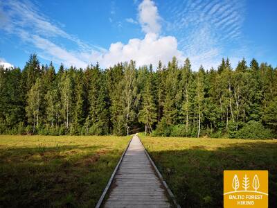
Im nordöstlichen Teil des Jugla-Sees in Jugla wurde ein 250 Meter langer Holzsteg (einfache Strecke) mit einer Aussichtsplattform mit Blick auf den Jugla-See, einer Bank, 20 taktilen Raumreliefs mit Darstellungen charakteristischer Tierarten des Sees und seiner Umgebung sowie Informationen in Blindenschrift angelegt. Der Weg ist für Rollstuhlfahrer zugänglich. Der Standort liegt 0,5 Kilometer vom Mežtaka-Pfad entfernt.


Taktilais Brīvības piemineklis
Enthüllt an Lettlands Geburtstag – dem 18. November 2022 – im Brīvības laukums gegenüber dem von Kārlis Zāles geschaffenen und am 18. November 1935 enthüllten Original. Diese besondere Bronzeminiatur wurde vom Bildhauer Ivars Miķelsons im Maßstab 1:50 geschaffen.


83. Etappe. Paplatelė – Plateliai.
Rund um die größten Seen im Nationalpark Žemaitija
Die ersten 3,5 km führt der Wald-Wanderweg durch wunderschöne Wälder, die die Hänge des Hochlandes Žemaitija bedecken. Bis zum Museum des Kalten Krieges fällt er mit dem Erkenntnispfad Plokštinė zusammen. 5 km vom Museum folgt der Wald-Wanderweg der Landstraße Plokštinė, wo ein Fußgänger- / Fahrradweg angelegt wurde und bei der Annäherung zum Platelių-See in die Seesenke hinabsteigt. An der Straße Nr. 3202 (Malūno-Straße) biegt der Wald-Wanderweg links nach Südosten ab und gleich nach 0,3 km folgt eine Rechtskurve nach Süd-Südwest. Nach ca. 0,5 km erreicht er die Ilgio Ežero Straße. Die nächsten 5,5 km legt der Wald-Wanderweg einen weiten Bogen um die Seen Ilgis und Beržoras und erreicht dann das Dorf Beržoras. Nach dem Dorf verläuft der Wald-Wanderweg entlang der Plungės-Straße, erreicht nach 2 km das Stadtzentrum von Plateliai und macht entlang der Ežero-Straße einen weiteren Bogen zum Strand und zu den Erkundungspfaden von Šeirė. Weiter entlang der Straßen Ežero, Naujoji und Žemaičių Kalvarijos kehrt der Wald-Wanderweg ins Stadtzentrum zurück.
Šeire's Educational Trail
Der Weg ist etwa 7 Kilometer lang, es gibt jedoch eine Aussichtsplattform, die für Rollstuhlfahrer zugänglich ist und einen Blick auf den Plateliai-See und seine Inseln bietet. Plateliai liegt im Nationalpark Žemaitija. Auf der Informationstafel ist eine taktile Karte des Sees mit seinen Inseln angebracht, sodass auch Sehbehinderte ihn erkunden können. Der Parkplatz befindet sich hier: GPS 56.048355, 21.826901. Er liegt neben dem Mežtaka-Weg.


Plokštines militārā pilsēta
Seit 1993 wird die ehemalige Anlage der sowjetischen Armee von der Direktion des Nationalparks Samogitia verwaltet. Viele Gebäude auf dem Militärcampus wurden 2017 aufgrund ihres baufälligen Zustands abgerissen. Derzeit sind in dem Areal noch etwa 10 Gebäude erhalten, die von Besuchern von außen besichtigt werden können. Es gibt Informationstafeln, die über die ehemaligen Gebäude und ihren Zweck informieren. Es wurde ein taktiler Stand installiert – eine Karte, die die Gebäude, ihre Lage und Funktionen vorstellt.


84. Etappe. Plateliai – Salantai.
Auf dem Weg zur Küstenebene
Der Wald-Wanderweg verläuft 6 km am Rand der Straße Plateliai – Salantai (Nr. 2302) entlang. In diesem Abschnitt öffnet sich ein Blick auf die Landschaften des westlichen Teiles des Hochlandes Žemaitija über die Tiefebene Pajūris. Im Zentrum des Dorfes Gintališkė biegt der Wald-Wanderweg links nach Südwesten ab und kommt auf die Straße Nr.3216. Nach 2,4 km biegt er rechts nach Westen ab, wo er das größte Waldmassiv dieses Abschnitts durchquert. Zu Sowjetzeiten befand sich hier ein Raketenstützpunkt, wie die mit Betonplatten gepflasterte Straße nachweist. Dann folgt der Wald-Wanderweg kurz der Straße Plungė – Salantai (Nr.169) und biegt nach 1,4 km links ab. Bis Salantai windet er sich auf einer kleinen Landstraße, aber das Zentrum der Kleinstadt erreicht man über die Straßen Žemaitės und M. Valančiaus. Der Anfang dieser Etappe befindet sich im Nationalpark Žemaitija, das Ziel ist jedoch im Regionalpark Salantai.
Šeire's Educational Trail
Der Weg ist etwa 7 Kilometer lang, es gibt jedoch eine Aussichtsplattform, die für Rollstuhlfahrer zugänglich ist und einen Blick auf den Plateliai-See und seine Inseln bietet. Plateliai liegt im Nationalpark Žemaitija. Auf der Informationstafel ist eine taktile Karte des Sees mit seinen Inseln angebracht, sodass auch Sehbehinderte ihn erkunden können. Der Parkplatz befindet sich hier: GPS 56.048355, 21.826901. Er liegt neben dem Mežtaka-Weg.
92. Etappe. Snēpele – Kuldīga.
Nach Kuldīga – die charmanteste mittelalterliche Stadt von Kurland
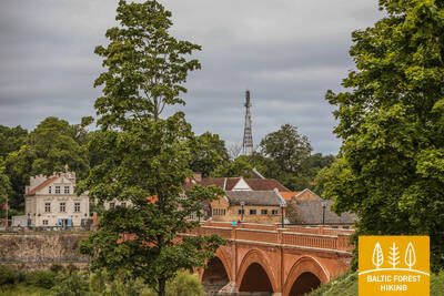
Entlang der Hauptstraße von Snēpeles führt der Wald-Wanderweg auf die Straße V1294 und biegt nach 0,3 km gegenüber dem See Ķepšu rechts auf eine kleine Landstraße ab. Über dieser Straße windet sich der Wald-Wanderweg bis zum Dorf Slipiņciems, davor überquert er den Fluss Sprincupe entlang dem Damm, wo ein Teich angelegt wurde. Dann geht der Wald-Wanderweg in Richtung Pelči. In der Umgebung von Pelči schlängelt sich der Wald-Wanderweg entlang der Damba-Teiche, führt zur Straße Kuldīga – Pelči (V1293) und führt weiter durch die Gartengebiete von Kuldīga – Kurzemīte und Rumba, bis er das Venta-Ufer und die Kuldīga Umgehungsstraße erreicht. Von dort zur Alten Backsteinbrücke führt der Wald-Wanderweg 2,4 km über einen schönen Uferpfad an der Venta, wo es an feuchteren Stellen und über Bäche Fußgängerbrücken und Holzstege gibt.
The walking trail along the Venta River in Kuldīga
Der Weg erstreckt sich am linken Ufer des Flusses Venta vom Stadtgarten Kuldīga bis zur neuen Kuldīga-Brücke und ist 2,4 Kilometer lang. Entlang des Weges gibt es Rastplätze und Informationstafeln. Er ist für Rollstuhlfahrer zugänglich, da er eine glatte Oberfläche aus feinem, hartem Kies hat, obwohl einige Abschnitte aufgrund von Steigungen möglicherweise Hilfe benötigen. Der Weg ist breit und an den Stellen, an denen er kleine Bachschluchten überquert, wurden Holzstege und Brücken angelegt. Dieser Abschnitt des Mežtaka-Weges verläuft entlang des Kuldīga-Promenadenwegs. Behindertengerechte Toiletten stehen zur Verfügung. Ein Parkplatz wurde bei GPS: 56.973354, 21.977798 eingerichtet.


 93. Etappe. Kuldīga – Renda.
Venta-Tal und Naturpark Riežupe
Hinter der Alten Backsteinbrücke über die Venta geht der Wald-Wanderweg kurz am rechten Ufer der Venta entlang, entlang der Schluchten, entlang der Krasta-Straße und der Straße Vetklīnika – Paleja, durchquert den Wald Kalnmuiža, Riežupe und weiter bis nach Mazrenda, über die Forstwege vom riesigen Waldmassiv von Renda. Das Relief hier ist flach, da der Abschnitt Teil der Pieventa-Ebene des Kursa-Tieflandes ist. In Mazrenda überquert der Wald-Wanderweg einen Sand-Kiesbruch und führt über die Kuldīgas-Straße ins Zentrum von Renda. Der Abschnitt gehört zum Territorium des Naturschutzgebietes „Ventas ieleja“ und des Naturparks „Riežupe“.
Audio guide "Through Mežtaka in Kuldīga for People with Visual Impairments"
Im Jahr 2024 wurde ein Audioguide mit dem Titel „Durch Mežtaka in Kuldīga für Menschen mit Sehbehinderung“ erstellt. Er beginnt am Aussichtsturm von Kuldīga, überquert die alte Backsteinbrücke über den Fluss Venta und hilft den Benutzern, den Kuldīga-Promenadenweg entlang der Venta zu erkunden. Informationen am Aussichtsturm und in der Nähe werden in Blindenschrift bereitgestellt. Ein Parkplatz wurde bei GPS: 56.973354, 21.977798 eingerichtet.


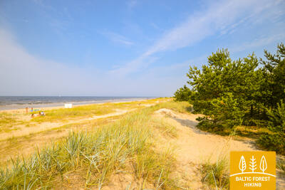
100. Etappe. Bigauņciems – Dubulti.
Der historische Kurort Jūrmala
Von Bigauņciema eröffnet sich ein weiter Ausblick über die ganze Küste von Jūrmala. Das erste Drittel dieses Streckenabschnitts führt durch den Nationalpark Ķemeri. Dort kann man sich mit historischen Fischerdörfern, der ehemaligen Fischerbootsanlegestelle und dem Fischmarkt in Ragaciems sowie den Dünenbiotopen vertraut machen. Auch kann man Vögel im Mündungsgebiet des Flusses Starpiņupīte beobachten. Von Jaunķemeri bis Dubulti verläuft der Pfad entlang dem breitesten Sandstrand der Rigaer Meeresbucht durch den historischen Kurort der Stadt Jūrmala und die längste Stadt Lettlands. An warmen und schönen Sommertagen muss mit zahlreichen Strandbesuchern gerechnet werden.
The Dubulti Coastal Dunes Trail
Im Jahr 2024/2025 wird ein Abschnitt des Jūrtaka-Pfades als spezielle Route für Menschen mit Sehbehinderung angelegt und angepasst.


101. Etappe. Dubulti - Lielupe - Bulduri.
Die beliebtesten Strände Lettlands
Zwischen Dubulti und Lielupe erstreckt sich der breiteste Sandstrand der Rigaer Meeresbucht – es ist der wertvollste Schatz des Kurorts Jūrmala, in dem es zahlreiche Strandcafés und verschiedene Erholungsmöglichkeiten gibt, Die Wälder der Küstendünen sind von einem dichten Wegenetz durchzogen, das zum Joggen und Wandern geeignet ist. Der Baltische Küstenwanderweg führt zwischen dem Strand Lielupe und dem Freilichtmuseum Jūrmala durch den Naturpark Ragakāpa. Am bequemsten zurück nach Bulduri gelangt man über die Straßen Bulduru prospekts und 5. līnija.
The Dubulti Coastal Dunes Trail
Im Jahr 2024/2025 wird ein Abschnitt des Jūrtaka-Pfades als spezielle Route für Menschen mit Sehbehinderung angelegt und angepasst.