


Лесная тропа прибалтики - For visually impaired


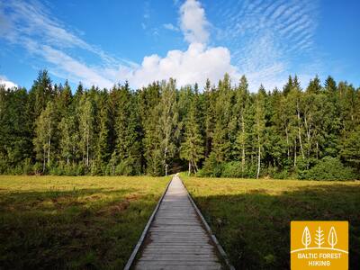
 1-й этап. Старая Рига – Балтэзерс.
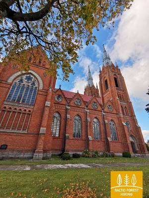
Сквозь Ригу – объект Всемирного наследия ЮНЕСКО
В Латвии Лесная тропа начинается в самом сердце Старой Риги – на Ратушной площади. Тропа идет по улице Калькю, мимо Памятника Свободы, через Верманский парк и по исторической улице Тербатас. Далее она устремляется к пешеходному мосту, пересекает железнодорожную станцию «Земитану» и продолжается в Бикерниекском лесу и лесном массиве Шмерлис. Лесная тропа проходит через Юглу, мимо Латвийского этнографического музея под открытым небом и по пешеходно-велосипедным дорожкам приводит в Балтэзерс.
The "Feel Jugla" Walking Trail
В северо-восточной части озера Югла в Югле создан 250-метровый деревянный настил (односторонний) со смотровой площадкой с видом на озеро Югла, скамейкой, 20 тактильными пространственными рельефами, изображающими характерные виды животных озера и его окрестностей, а также информацией на языке Брайля. Он доступен для людей в инвалидных колясках. Объект расположен в 0,5 км от тропы Межтака.


Taktilais Brīvības piemineklis
Открыта в день рождения Латвии - 18 ноября 2022 года - на площади Бривибас напротив оригинала, созданного Карлисом Залесом, и открыта 18 ноября 1935 года. Эту особую бронзовую миниатюру создал скульптор Иварс Микельсонс в масштабе 1:50.


83-й этап. Paplatelė – Plateliai.
Среди крупнейших озёр Жемайтийского национального парка
Первые 3,5 км Лесная тропа ведёт через красивейшие хвойные леса. До Музея холодной войны тропа совпадает с познавательной тропой Плокштине, а 5 км от музея – с пешеходной и велосипедной дорожкой Плокштине. У шоссе № 3202 (улица Малуно) маршрут сворачивает налево на юго-запад и сразу, через 0,3 км, направо на юго-юго-запад. Приблизительно через 0,5 км выходит на улицу Ильгё эжеро. Затем на протяжении 5,5 км маршрут делает широкий круг вокруг озёр Ильгис и Бержорас, пока не выведет к деревне Бержорас. Через 2 км по улице Плунге Лесная тропа приводит в центр Плателяй и делает ещё один круг по улице Эжеро до познавательной тропы Шейре, открывая живописный ландшафт. Далее по улицам Эжеро, Науёйи и Жямайчю Калвариёс возвращается в центр города.
Šeire's Educational Trail
Длина тропы составляет около 7 километров, но есть смотровая площадка, доступная для людей в инвалидных колясках, с которой открывается вид на озеро Плателяй и его острова. Плателяй находится в Национальном парке Жемайтия. На информационном щите размещена тактильная карта озера с островами, что позволяет людям с нарушениями зрения исследовать его. Парковка находится здесь: GPS 56.048355, 21.826901. Она расположена рядом с тропой Межтака.


Plokštines militārā pilsēta
С 1993 года бывший объект Советской Армии находится в ведении Дирекции национального парка Жемайтия. Многие здания на территории военного городка были снесены в 2017 году из-за их ветхого состояния. В настоящее время на территории сохранилось около 10 зданий, которые посетители могут осмотреть снаружи. Имеются информационные стенды, рассказывающие о бывших зданиях и их назначении. Установлен тактильный стенд — карта, знакомящая со зданиями, их расположением и функциями.


84-й этап. Plateliai – Salantai.
В направлении Приморской низменности
Лесная тропа на протяжении 6 км проходит по бровке шоссе Плателяй–Салантай (№ 2302). На этом этапе маршрут спускается вниз по западной части Жемайтской возвышенности. Во время путешествия в направлении Приморской низменности открывается красивейшая панорама ландшафта. В центре деревни Гинталишке Лесная тропа уходит налево на юго-запад и 2,4 км петляет по шоссе № 3216, затем сворачивает направо на запад, где пересекает крупнейший на этом этапе лесной массив. В советские времена здесь находилась ракетная база, что доказывает выложенная бетонными плитами дорога. Затем маршрут совпадает с шоссе Плунге–Салантай (№ 169) и через 1,4 км уходит влево. До города Салантай тропа петляет по небольшой дорожке, а к центру города ведёт по улицам Жемайтес и М. Валанчяус. Начало маршрута – Жемайтийский национальный парк, окончание – Салантайский региональный парк.
Šeire's Educational Trail
Длина тропы составляет около 7 километров, но есть смотровая площадка, доступная для людей в инвалидных колясках, с которой открывается вид на озеро Плателяй и его острова. Плателяй находится в Национальном парке Жемайтия. На информационном щите размещена тактильная карта озера с островами, что позволяет людям с нарушениями зрения исследовать его. Парковка находится здесь: GPS 56.048355, 21.826901. Она расположена рядом с тропой Межтака.
92-й этап. Snēpele – Kuldīga.
Кулдигa – самый очаровательный средневековый город Курземе
Лесная тропа ведёт по главной улице Снепеле к дороге V1294 и через 0,3 км перед озером Кепшу сворачивает вправо на деревенскую дорогу. По этой дороге маршрут достигает Слипинциемса, перед этим пересекая плотину Спринцупе, и проходит вдоль пруда. Далее маршрут поворачивает по направлению к Пелчи, где петляет вдоль Дамбовых прудов, ведет к дороге Кулдига – Пелчи (V1293) и продолжается через сады Кулдиги «Курземите» и «Румба», до реки Вента и Кулдигской объездной дороги. Этап маршрута длиной 2,4 км от объездной дороги до Старинного кирпичного моста ведёт по красивой прибрежной тропе реки Венты, где во влажных местах и через ручьи проложены деревянные мостки.
The walking trail along the Venta River in Kuldīga
Тропа тянется вдоль левого берега реки Вента от городского сада Кулдиги до нового моста Кулдиги, охватывая 2,4 километра. Вдоль тропы установлены места для отдыха и информационные щиты. Тропа доступна для людей в инвалидных колясках благодаря своей гладкой поверхности, состоящей из мелкого твердого гравия, хотя на некоторых участках может потребоваться помощь из-за уклонов. Тропа широкая, и там, где она пересекает небольшие овраги ручьев, построены деревянные настилы и мосты. Этот участок тропы Межтака проходит вдоль тропы променада Кулдиги. Доступны адаптированные туалеты. Оборудована парковка по координатам GPS: 56.973354, 21.977798.


 93-й этап. Kuldīga – Renda.
По долине реки Вента и природному парку Риежупе
За старинным кирпичным мостом через Венту Лесная тропа ненадолго проходит по правому берегу реки, по ул. Краста и по дороге Ветклиника-Палея, затем пересекает Калнмуйжский лес, Риежупе и дальше до Мазренды тянется широкими лесными дорогами Ренды. Рельеф здесь ровный, поскольку отрезок пути пролегает по Пьевентской равнине Куршской низменности. В Мазренде маршрут проходит через песчано-гравийный карьер и по ул. Кулдигас ведёт в центр Ренды. Весь маршрут проходит по территории природного заповедника долины реки Вента и природного парка Риежупе.
Audio guide "Through Mežtaka in Kuldīga for People with Visual Impairments"
В 2024 году был создан аудиогид под названием «По Межтаке в Кулдиге для людей с нарушениями зрения». Он начинается у смотровой башни Кулдиги, пересекает старый кирпичный мост через реку Вента и помогает пользователям исследовать тропу променада Кулдиги вдоль Венты. Информация на смотровой башне и поблизости представлена шрифтом Брайля. Обустроена парковка по координатам GPS: 56.973354, 21.977798.


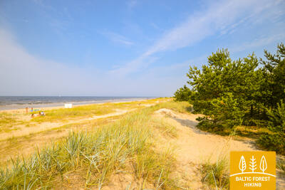
100-й этап. Bigauņciems – Dubulti.
По Юрмале – историческому курорту
С Бигаунциемса хорошо виден весь берег Юрмалы. Первая часть этапа пути на сегодняшний день лежит через Кемерский национальный парк. От Яункемери до Дубулты пеший маршрут проходит по самому широкому песчаному пляжу Рижского залива, через исторический курорт и самый длинный в Латвии город - Юрмалу. Стоит помнить, что в красивые и теплые летние дни на пляже бывает много отдыхающих.
The Dubulti Coastal Dunes Trail
В 2024/2025 учебном году участок Юртакской тропы будет создан и адаптирован как специальный маршрут для людей с нарушениями зрения.


101-й этап. Дубулти – Лиелупе – Булдури.
Самые популярные пляжи Латвии
Между Дубулти и Лиелупе раскинулся самый широкий пляж на побережье Рижского морского залива – главнейшая ценность города-курорта Юрмалы – с многочисленными пляжными кафе и разнообразными возможностями отдыха. Леса в прибрежных дюнах пронизаны плотной сетью тропинок, которые подходят для обычной и скандинавской ходьбы. Часть Тропы Балтийского взморья между пляжем Лиелупе и Юрмальским музеем под открытым небом проходит по территории природного парка «Рагакапас». Отсюда обратно в Булдури можно легко попасть по проспекту Булдуру и 5-й линии.
The Dubulti Coastal Dunes Trail
В 2024/2025 учебном году участок Юртакской тропы будет создан и адаптирован как специальный маршрут для людей с нарушениями зрения.