


Baltischer Wald-Wanderweg - North Estonian coastline

Nordestnische Küste
STEILKÜSTE, WASSERFÄLLE, FINDLINGE UND DER NATIONALPARK LAHEMAA
Kuremäe – Tallinn, 344 km, 34.–50. Tag
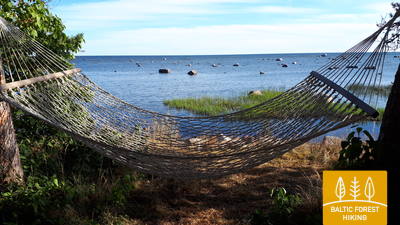
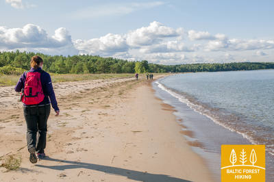
In Nordestland wird die Natur wilder, nordischer. Hier finden sich riesige, fast haushohe Findlinge, die das Eis vor 10.000 Jahren aus dem Norden mitbrachte. Breite Wasserfälle – nach hiesigen Maßstäben sehr groß – stürzen den Baltischen Glint hinab. Diese Steilküste aus Kalkstein zieht sich an der Ostsee entlang, ganz direkt oder in ihrer Nähe. An vielen Stellen bieten sich atemberaubende Ausblicke auf das Meer. An den Stränden kann man Fossilien finden. Charakteristisch für den Nationalpark Lahemaa und seine Umgebung sind die vielen Buchten, Halbinseln und dünn oder gar nicht besiedelten Inseln – unberührte Natur allerorten. Der Baltische Wald-Wanderweg führt durch die für Estland typischen Wacholderheiden und findet sein Ende im Zentrum von Tallinn.
Die eindrucksvollsten sehenswürdigkeiten: Baltischer Glint – einer der mächtigsten Kalksteinsockel Nordeuropas, Wasserfälle und riesengroße Findlinge, Industriegeschichte von Kunda, Lahemaa – der älteste Nationalpark in den baltischen Ländern, Altja – ein traditionelles Fischerdorf, Käsmu – das "Dorf der Kapitäne", Purekkari-Kap– nördlichster Punkt des estnischen Festlandes, Militärische Vergangenheit – Küstenbefestigungen an der Ostsee – die Uferbefestigungen und die Küstenwache, Pirita – "Badewanne Tallinns" und Olympiazentrum, Altstadt von Tallinn – UNESCO-Weltkulturerbe.
 34. Etappe. Kuremäe – Vasavere.
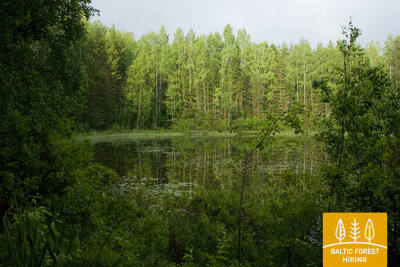
Im Landschaftsschutzgebiet Kurtna
Im weiteren Verlauf führt der Baltische Wald-Wanderweg den Klosterberg von Kuremäe hinab und taucht in das äußerst malerische Landschaftsschutzgebiet Kurtna ein, das Teil des Alutaguse-Nationalparks ist. Zwischen schönen, lichten Nadelwäldern liegen 42, zumeist kleine Seen (was aus dem LSG Kurtna die seenreichste Gegend Estlands macht). An feuchteren Stellen sind hölzerne Stege eingerichtet; Holzbrücken führen über Bäche und kleinere Flüsse. In der Nähe des Sport- und Erholungszentrums Alutaguse warten mehrere Wander- und Nordic-Walking-Pfade auf Besucher.
35. Etappe. Vasavere – Toila.
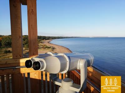
Auf dem Weg Steilküste bei Toila Nordestlands bei Toila
Hinter Vasavere verläuft der Baltische Wald-Wanderweg noch eine kurze Strecke durch das Landschaftsschutzgebiet Kurtna, führt dann um einen Torfabbau, durchquert das Dörfchen Oru und erreicht in einem Bogen um das Voka-Flusstal die Ostseeküste, wo er sich in Richtung Westen fortsetzt. Am Ufer des Finnischen Meerbusens ragt die waldbewachsene nordestnische Steilküste, auch Baltischer Glint genannt, in fast schwindelerregende Höhen. Dieser Kalksteinsockel erstreckt sich – mit ein paar Unterbrechungen – bis nach Tallinn und dann weiter bis zu den westestnischen Inseln – mal als Steilküste direkt am Meer, mal als Höhenzug im Binnenland. Der Baltische Wald-Wanderweg verläuft über weite Strecken auf dem Glint und verlässt ihn nur, um in einige Flusstäler hinabzuführen. Im Park von Toila-Oru überquert der Pfad das recht tiefe und weitläufige Tal des Pühajõgi und erreicht anschließend den bekannten Küstenkurort Toila.
 36. Etappe. Toila – Saka.
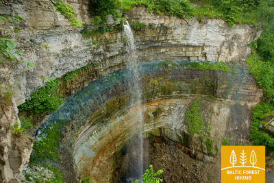
Die malerische Steilküste zwischen Toila und Saka
Einer der imposantesten Streckenabschnitte des Baltischen Wald-Wanderweges führt vom Fuße der nordestnischen Steilküste bei den Dörfern Valaste und Saka die Felswand hinauf. Von hier oben eröffnet sich Ihnen eine atemberaubend schöne Aussicht auf den Finnischen Meerbusen. Auf der ca. 23 km langen Strecke von Toila über Ontika nach Saka erreicht die Steilküste ihre maximale Höhe von 55 Metern. Bei klarem Wetter kann man von hier aus die 50 km weit entfernten, zu Russland gehörenden Inseln Suur Tütarsaar und Väike Tütarsaar erkennen.
37. Etappe. Saka – Aseri.
Millionen Jahre alte Fossilien am Meeresufer
Am Gutshof Saka führt der Baltische Wald-Wanderweg steile Stufen zum Ostseeufer hinab und verläuft die nächsten 6 km entlang des Strandes. In der Nähe der Dörfer Moldova und Jabara geht es wieder hinauf auf den Baltischen Glint und von dort weiter durch das Dorf Purtse, um den Purtse-Fluss herum und dann wieder am Strand, der hier schmaler ist, entlang bis nach Aseri. Am Meeresufer findet man hier und dort Tierfossilien, die mehrere hundert Millionen Jahre alt sind. Bevor man Aseri erreicht, geht es die Steilküste noch einmal nach oben.
 38. Etappe. Aseri – Mahu.
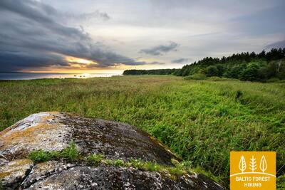
Zwischen Meer und Wäldern
Bevor die heutige Wanderung beginnt, lohnen sich ein Spaziergang zum Strand und ein Blick auf die großen Tagebaue. Bereits in alten Zeiten wurde hier Ton für die Ziegelherstellung gewonnen; der Tagebau ist bis heute aktiv. Hinter Aseri durchquert der Baltische Wald-Wanderweg ein ehemaliges sowjetisches Militärgelände, verläuft dann auf dem Baltischen Glint und gewährt herrliche Ausblicke auf den Finnischen Meerbusen. Später erreicht der Weg das eindrucksvolle Gutshaus von Kalvi und verläuft weiter entlang der Landstraße in Richtung Mahu. Nach dem Durchqueren eines schönen Nadelwaldes in einem Naturschutzgebiet hinter dem Fluss Pada führt der Wanderweg wieder zum Strand und setzt sich anschließend durch die Küstenwälder bis zum Ziel, dem Dorf Mahu, fort.
39. Etappe. Mahu – Kunda.
Die Industriegeschichte Kundas kennenlernen
Von Mahu bis Letipea verläuft der Baltische Wald-Wanderweg auf kleinen Küstenwegen nahe der Ostsee und eine kurze Strecke sogar direkt entlang des Strandes. In der Nähe der Landspitze von Letipea trifft man auf dichte Wacholderbestände. Es lohnt sich, einen Abstecher zum im Wasser gelegenen großen Ehalkivi-Findling zu machen (hin und zurück etwa 1,5 km). Von Simunamäe verläuft die Wanderroute 3 km auf einem Weg durch einen Urwald am Fuße des Baltischen Glints. Der Weg ist hier circa einen Kilometer weit vom Meeresufer entfernt. Am Gutshof Lontova gibt es mehrere Informationstafeln, die über die Geschichte des Städtchens Kunda Auskunft geben. An den Ufern des gleichnamigen Flusses und im Ort selbst können Objekte besichtigt werden, die mit der Geschichte der Zementherstellung verbunden sind.
40. Etappe. Kunda – Eisma.
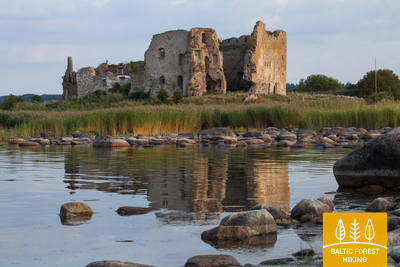
Fischfang und Kunst an der Küste von Kunda
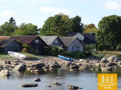
Nach dem interessanten Zwischenstopp in Kunda kehrt der Baltische Wald-Wanderweg zum Baltischen Glint zurück und setzt sich weitere 2 km auf ihm fort. Anschließend geht es über eine asphaltierte Straße weiter. In Toolse sollte unbedingt der Besuch der gleichnamigen Burgruine (estnisch: Toolse linnus) aus dem 15. Jahrhundert eingeplant werden, die etwa 2 km entfernt liegt. Es handelte sich um die nördlichste Festung des Deutschen Ordens. An der Brücke über den Selja-Fluss können von Zeit zu Zeit Vorrichtungen zum Fang von Neunaugen zu sehen sein. Die Anlagen gehören dem Museum, das auf einem schönen Bauernhof eingerichtet und vom rechten Flussufer neben der Brücke zu erkennen ist. Von Toolse nach Eisma führt der Baltische Wald-Wanderweg am Rande einer Landstraße entlang und erreicht kurz vor dem Ziel die schöne, steinübersäte Ostseeküste, die auf ihrer westlichen Seite zu einem breiten Sandstrand wird.
41. Etappe. Eisma – Oandu.
Durch den Nationalpark Lahemaa
Hinter dem Dörfchen Vainupea überschreitet der Baltische Wald-Wanderweg die Grenze zum ältesten estnischen Nationalpark – Lahemaa. Ins Deutsche übersetzt bedeutet dies „Land der Buchten“. Mehr als fünf Tage wird die Wanderung durch die an Halbinseln und Buchten reiche Küstenlandschaft des Nationalparks dauern. Während dieser Zeit werden Sie die wichtigsten Natur- und Kulturschätze der Gegend kennenlernen. Achten Sie bitte auf die im Nationalpark teilweise geltenden besonderen Regeln.
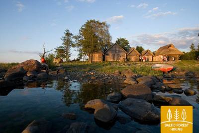
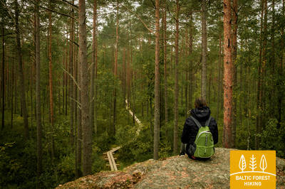
Auf dieser Etappe verläuft der Weg durch schöne und stille Küstenwälder, in denen im Herbst unzählig viele Pilze und Beeren wachsen. Später erreichen Sie das malerische Fischerdorf Altja. Gegen Ende der Etappe kommen Sie im Nachbardörfchen Oandu zum Besucherzentrum des Estnischen Forstamtes (RMK), wo Sie interessante Informationen zu Waldbiotopen und zur Forstgeschichte erhalten können.
42. Etappe. Oandu – Käsmu.
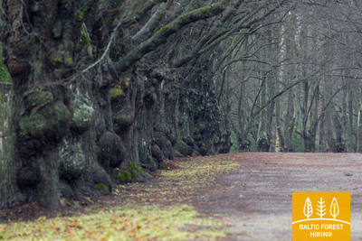
Idyllisches "Kapitänsdorf" Käsmu
Die etwa 9 km lange Strecke zwischen Oandu und Võsu verläuft durch eine schöne, waldbedeckte Binnendünenlandschaft. An manchen Kiefernstämmen sind eigenartige Muster zu sehen, die auf eine ehemalige Harzgewinnung hindeuten. Harz wurde in den baltischen Wäldern bis in die 70er Jahre des 20. Jahrhunderts gewonnen. Viele Baumstämme sind dicht mit Flechten bewachsen, die ein Indikator für reine Luft sind. Im Herbst finden sich Pilze sowie Heidel- und Preiselbeeren am Wegesrand. Gefolgt von einem Abstecher nach Võsu, einem beliebten kleinen Ferienort, führt der Wanderweg entlang einer Ostseebucht durch Küstenwälder bis nach Käsmu. Hier lohnt es sich, den ganzen idyllischen Ort von Süd nach Nord zu durchwandern und die an der Spitze der gleichnamigen Halbinsel liegenden riesigen Findlingssteine zu bestaunen.
43. Etappe. Käsmu – Viinistu.
Im Bezaubernde Käsmu-Halbinsel
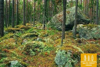
Das erste Drittel dieser Etappe des Baltischen Wald-Wanderweges verläuft über die Halbinsel Käsmu. In der Landschaft mit ihren waldbedeckten Dünen und moosbewachsenen Steinen fühlt man sich wie in einem geheimnisvollen Märchenland. Bei Eru führt der Weg 2 km entlang der Landstraße Võsu-Kotka, passiert die Ortschaft Vihasoo und setzt sich längs des Straßenrandes fort. Ab und zu tauchen die Eru-Bucht und die Halbinsel Käsmu auf. Auf dieser Etappe kann man einige der eindrucksvollsten Findlinge des Nationalparks Lahemaa und ganz Estlands bestaunen: den Tammispea- und den Jaani-Tooma-Suurkivi-Stein – riesige Brocken aus Granit. Von Viinistu hat man einen guten Ausblick auf die Insel Mohni und den Leuchtturm.
44. Etappe. Viinistu – Loksa.
Purekkari – der nördlichste Punkt des estnischen Festlands
Weiter führt der Baltische Wald-Wanderweg über die Pärispea-Halbinsel, die zum Nationalpark Lahemaa gehört, und erreicht das Kap Purekkari. Bei Windstille sollte man es sich nicht nehmen lassen, den auf dem einen Kilometer langen und mit Kieselsteinen bedeckten Kap befindlichen eindrucksvollen Purekkari-Stein zu besichtigen. Im weiteren Verlauf folgt der Wanderweg den kurvenreichen Küstenwegen an der Hara-Bucht, passiert mehrere Siedlungen, die einst dem sowjetischen Grenzschutz dienten, und durchquert die Kleinstadt Loksa. Im nördlichen Teil des Ortes befand sich einst eine Ziegelei, von der noch heute einige alte Gebäude existieren. Nachdem Sie den Ortskern durchwandert haben, kommen Sie an den Zielpunkt dieser Etappe. Ein wunderschöner Strand befindet sich in nur 500 Metern Entfernung.
45. Etappe. Loksa – Tsitre.
Durch die Wälder und Moore der Juminda-Halbinsel
An diesem Tag durchquert der Baltische Wald-Wanderweg die Halbinsel Juminda. 7 km hinter Loksa biegt der Weg ein gutes Stück vor dem ehemaligen sowjetischen U-Boot-Hafen Hara ab. Wer den Hafen besichtigen möchte (kostenpflichtig), muss weitere 2 km zurücklegen. Im weiteren Verlauf führt der Wanderweg durch ein atemberaubend schönes Wald-Sumpf-Moorgebiet, Wald- und Sumpfgebiet, das im Westen von hohen, waldbedeckten Sanddünen eingefasst wird. Zwischen Pedaspea und Tsitre verläuft der Weg entlang einer Landstraße und kommt vor Tsitre nah an den Baltischen Glint. Nördlich liegt der Muuksi-Burghügel. Etwa 0,2 km vom Strand entfernt gibt es in Tsitre einen Rastplatz.
46. Etappe. Tsitre – Kaberneeme.
Sandstrände und die Inseln der Kolga-Bucht
Bereits in der Wikingerzeit gab es bei der alten Siedlung Tsitre einen Hafen. Die ersten 4 km des Baltischen Wald-Wanderweges verlaufen hier noch durch den Nationalpark Lahemaa. Zwischen den Siedlungen Muuksi und Soorinna durchquert der Weg einen ovalen plateauähnlichen Hügel, eine Erhebung des Baltischen Glints, auf dem sich eine malerische Wacholderheidenlandschaft ausbreitet. Bei Põhja führt der Wanderweg um ein Küstenfeuchtegebiet herum und erreicht hinter dem Bootshafeno von Salmistu den Meeresstrand. Von hier aus sieht man im Nordosten die 1,3 km weite Pedassaar-Insel, im Nordwesten die kleine Umblu- und die etwas größere Rohusi-Insel. In Valkla lädt ein Strandrestaurant zu einem Besuch ein. In Haapse gibt es einen Strandabschnitt, der sich gut zum Schwimmen eignet, da die Ostsee hier recht schnell recht tief wird.
47. Etappe. Kaberneeme – Jõelähtme.
An den Ufern des Jägala-Flusses
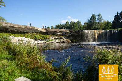
Von Kaberneeme setzt sich der Weg durch einen Wald fort, in dem man aus der letzten Eiszeit stammende Steinhaufen sehen kann. Später steigt der Baltische Wald-Wanderweg auf etwa 20 Meter hinauf und führt an der verlandeten Küstenlinie des Ostsee-Vorgängers, des Ancylussees, entlang. Bevor der Weg die Holocaust-Gedenkstätte von Kalevi-Liiva erreicht, überquert die Route die Landstraße Kaberla-Kaberneeme und führt durch das Tal des Kaberla-Bachs. Weiter geht es zum Wasserkraftwerk und der Hängebrücke von Linnamäe, an der alten Wallburg von Linnamäe vorbei und am rechten Ufer des Flusses Jägala entlang bis zum gleichnamigen Wasserfall. Etwa 500 m flussaufwärts wird die Suka-Brücke überquert. Zu guter Letzt passiert der Weg das Dorf Koogi und endet danach Jõelähtme.
48. Etappe. Jõelähtme – Muuga.
Durch den Phosphoritabbau von Maardu
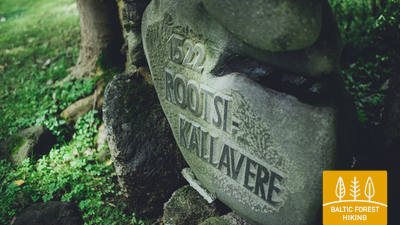
Der Baltische Wald-Wanderweg verlässt die Jõelähtme und biegt einen Kilometer vor der Ostsee in Richtung Nordwesten ab. Die nächsten 3 km verlaufen am Fuße des Baltischen Glint. Hinter Ülgase passiert der Weg die Vorstädte Tallinns – Kallavere, Maardu und Muuga. Von Muuga ist Tallinn in einigen Stunden zu Fuß zu erreichen. Doch die Route führt nicht auf direktem Wege in die estnische Hauptstadt, sondern vorher noch für zwei Tage über die Halbinsel Viimsi.
49. Etappe. Muuga – Püünsi.
Viimsi – eine Halbinsel mit vielen Facetten
Der Baltische Wald-Wanderweg durchquert den am stärksten bewaldeten Teil der Halbinsel Viimsi mit mehreren Naturschutzgebieten. Bei Rohuneeme passiert der Weg ein ehemaliges sowjetisches Militärgebiet. An diesem Tag wandert man vorwiegend auf Bürgersteigen und einem dichten Wegenetz. In Püünsi biegt der Weg in Richtung Süden ab. Von hier aus kann man über die Ostsee in der Ferne die Hochhäuser Tallinns und die Kirchtürme seiner Altstadt sehen. Daneben entdeckt man den Hafen, von dem aus es hervorragende Verbindungen nach Helsinki gibt.
50. Etappe. Püünsi – Tallinn.
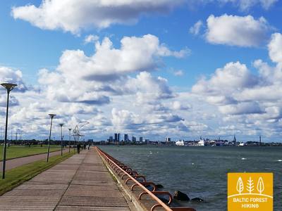
Postkartenblicke auf Tallinn
Die letzte Etappe des Baltischen Wald-Wanderweges führt die Bucht von Tallinn entlang in Richtung Süden. Immer wieder präsentieren sich die Türme der Altstadt, der vorgelagerte Hafen und die neuzeitlichen Wolkenkratzer in wechselnden Panoramen. Vor dem Erreichen des schon zu Tallinn gehörenden Stadtteils Pirita zieht sich der Weg durch einen schönen Wald und setzt sich anschließend entlang des Sandstrandes weitere zwei Kilometer fort. Ab dem ehemaligen Olympiazentrum wandert man über die beeindruckende Uferpromenade stadtwärts und kann dabei herrliche Ausblicke auf die Ostsee und den Hafen genießen. An letzterem endet der Baltische Wald-Wanderweg dann auch; von hier ist es nur noch ein Katzensprung in die Altstadt. Für den Besuch Tallinns sollten Sie mindestens zwei weitere Tage einplanen.