


Tропa Балтийского взморья - For visually impaired


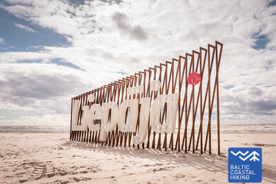
 Atkarpa 3. Bernāti - Liepāja - Karosta (Karinis uostas).
Miestas, kuriame gimsta vėjas
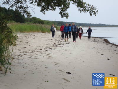
No Bernātiem līdz Liepājai Jūrtaka ved pa platu liedagu, kur sauszemes pusē sākotnēji ir vērojami noskaloti krasti, bet, tuvojoties Liepājai, augstas priekškāpas, apaugušas ar smiltāju kāpukviešiem un kāpuniedrēm. Tālāk tā izlīkumo cauri Liepājas vecpilsētai un Jaunliepājai un, šķērsojot Karostas kanālu, nonāk līdz Karostai - militāro un fortifikācijas būvju kompleksam, kuras apskatei ir vērts ieplānot vismaz pusi dienas. Noteikti jānogaršo Liepājas īpašais ēdiens – ”Liepājas menciņi”, kas gatavots no kūpinātas mencas pēc senas Dienvidkurzemes receptes.
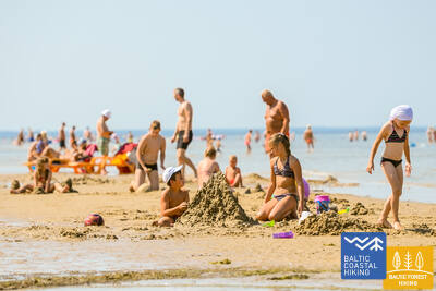
Liepāja Beach near the Central Rescue Station
Liepājas pludmalē pie Centrālās glābšanas stacijas (GPS: 56.504199, 20.991922) ir izveidots komplekss cilvēkiem ar funkcionaļiem traucējumiem - ierīkotas dušas, pārģērbšanās telpas, koka laipas ved līdz pašai jūrai, tādēļ cilvēki ar ratiņkrēsliem var nokļūt līdz pašai jūrai. Ir pieejami īpaši ratiņkrēsli, kas piemēroti peldēm jūrā. Neredzīgiem un vājredzīgiem cilvēkiem jūrā ir izvietotas audiobojas, kas ar signāla palīdzību sniedz informāciju - cik tālu var peldēt.


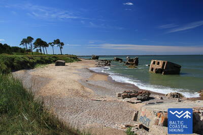
 Atkarpa 4. Karosta (Karinis uostas) - Ziemupe.
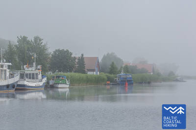
Karosta - karinis paveldas ant Baltijos jūros kranto
Pirmie četri Jūrtakas kilometri ar daudzu fortu un krasta aizsardzības bateriju paliekām var interesēt militārās vēstures entuziastus, taču no iešanas viedokļa tas ir tehniski sarežģītākais Kurzemes piekrastes posms. Aiz Cietokšņa kanāla Jūrtaka īsu brīdi izlokās pa piekrastes pļavu, tad izskrien liedagā un turpinās līdz pat Ziemupei. Liedags ir plats, stiprāka vēja laikā - ar sašaurinājumu starp Lenkupi un Kārļupīti. Dažviet nelieli stāvkrasti, pārējās vietās – augstas, vietām noskalotas priekškāpas. Stāsta, ka Ziemupes selgā nogrimuši daudzi kuģi, viens pat ar bronzas lielgabaliem.
Paths at Dvēseles Veldzes Dārzs
Dārzā ir izveidotas 2 īsas dabas takas, kas pielāgotas vājredzīgajiem un neredzīgajiem - Baso pēdu taka (530 m), Sajūtu parks un Labirints. Baso pēdu takā ik pēc 10 m mainās segums, kas mijas ar dažādu grūtības pakāpju šķēršļiem. Izveidota speciāla autostāvvieta, pielāgota WC, pieejami taktilie objekti, audioinformācija un informācija Braila rakstā. Atrodas ap 2,5 km no Jūrtakas.


 Atkarpa 10. Ventspils - Staldzene.
Ventspilio miestu
Maršruts ved cauri Ventspilij un tās apkārtnes mežiem. Jūrtaka no Dienvidu mola izlīkumo cauri vēsturiskajam Ostgalam un Vecpilsētai, šķērso Ventu un tālāk cauri Pārventai pa gājēju – veloceliņu turpinās Staldzenes virzienā, kur, apmetusi loku ap Ventspils ostu, atkal atgriežas jūras krastā. Ir vērts paņemt vienu "brīvdienu" un iepazīt pilsētas interesantākās vietas, kā arī apmeklēt Piejūras brīvdabas muzeju.
Lake Būšnieki Nature Trail
Veidota apkārt Būšnieku ezeram 9 km garumā. Taka ir pielāgota cilvēkiem ar ratiņkrēsliem un vecākiem ar bērnu ratiem Ir izveidots audiogids, taktīlā informācija un autostāvvieta cilvēkiem ar kustību traucējumiem. Piemērota vieta uzsākšanai ir autostāvlaukums Būšnieku ezera DA pusē (GPS: 57.437632, 21.656062). Līdz Jūrtakai (tuvākā vieta) ir aptuveni 1 km.


Atkarpa 17. Ģipka - Kaltene.
Akmenuotas Kuržemės paplūdimys
No Ģipkas līdz Rojai stiepjas smilšaina, ne pārāk plata pludmale ar skaistām kāpām un piekrastes priežu mežiem, bet pirms Rojas – tā ir aizaugusi ar niedrēm. Savukārt, posms starp Roju un Kaltenes baznīcu ir savdabīgākais visā Latvijas piekrastē, kur jūras krasts ir izrobots ar maziem zemesragiem un līcīšiem ar ļoti šauru pludmali, kuru viscaur klāj dažādu izmēru laukakmeņu krāvumi, virs kuriem līkst melnalkšņu zaļā lapotne. Dažviet krastā slejas izskaloto koku plašās sakņu rozetes. Vietām gar pašu krastu iet zemes ceļš, gar kuru rindojas daudzas bijušās zvejnieku sētas. Maršruts piemērots aktīviem un izveicīgiem gājējiem!
Lībiešu valodā Ģipka senais nosaukums Gipk.
Walking Path at Roja Beach
Koka laipas ir pielāgotas cilvēkiem ratiņkrēslos un vecākiem ar bērniem. Ir izveidots informatīvais stends Braila rakstā un pludmales taktīlā karte, pielāgota WC un autostāvvieta (GPS: 57.510088, 22.799207). Laipu garums vienā virzienā - 0,5 km. Cilvēki ratiņkrēslos var izmantot laipas, bet līdz jūrai nevar tikt, jo nav nobrauktuves. Laipas ir platas, ar aizsargvalnīti malās un samainīšanās laukumiem.
Atkarpa 21. Ragaciems - Dubulti.
Istorinis Jūrmalos kurortas
No Ragaciema labi redzams Jūrmalas krasts visā tā garumā. Šīs dienas posma pirmā trešdaļa ietilpst Ķemeru Nacionālajā parkā, kur var iepazīt vēsturiskos zvejniekciemus, Ragaciema sedumu un zivju tirdziņu, kāpu biotopus, kā arī vērot putnus Starpiņupītes grīvā. No Jaunķemeriem līdz pat Dubultiem gājiens norit pa Rīgas jūras līča platāko smilšu pludmali, cauri Jūrmalas vēsturiskajam kūrortam un Latvijas garākajai pilsētai. Skaistās un siltās vasaras dienās jārēķinās ar daudzajiem pludmales apmeklētājiem.
The Dubulti Coastal Dunes Trail
Jūrmalas piekrastē, kāpu joslā no Baznīcas ielas Dubultos līdz Amatas ielai Pumpuros, aptuveni divu kilometru garumā izveidota dabas taka, kas paredzēta mierīgai atpūtai, iepazīšanai ar apkārtējo vidi un dažādām kustību aktivitātēm.
Taka ir ērti izmantojama gan pastaigu cienītājiem, gan nūjotājiem un skrējējiem. Maršrutā var izjust piejūras kāpu raksturīgo ainavu un mainīgo reljefu.
Ceļā izvietoti norobežojoši elementi, trīs atpūtas soliņi, koka seguma laukums ar piknika galdu un sēdvietām, skatu platforma un terase ar izstieptu tīklu. Ir arī īpašs sensorais posms, kurā var sajust dažādus dabas materiālus — smiltis, oļus un čiekurus. Takas vidē izvietoti divi trenažieri, kas dod iespēju izkustēties un izvingroties. Maršruts aprīkots ar norādēm, kā arī informatīviem stendiem par vietējo dabu, veselīgu dzīvesveidu un fizisko aktivitāšu nozīmi cilvēka pašsajūtai.
Labsajūtas dabas takā esošie informatīvie stendi ir papildināti ar taktilām kartēm cilvēkiem ar redzes traucējumiem. Izmantojot tausti, tie ļaus iegūt priekšstatu par taku, tās izvietojumu attiecībā pret apkārtnes ielām un uz kartes ir izvietota informācija braila rakstā.
Karšu dizainu veidoja un kartes izgatavoja kompānija "Socintegra", kas specializējas plaša spektra vides pielāgošanas pakalpojumu sniegšanā.
Par taku ir pieejams audio gids aplikācijā Izi.Travel. (Labsajūtas dabas taka / Wellness nature trail) latviešu un angļu valodās un ar tā palīdzību ir iespējams audio formātā noklausīties informāciju, kas izvietota uz takas informatīvajiem stendiem.


Atkarpa 22. Dubulti - Lielupe - Bulduri.
Populiariausi paplūdimiai Latvijoje
Plačiausias Rygos įlankos smėlio paplūdimys driekiasi nuo Dubultų iki Lielupės upės. Tai didžiausia Jūrmalos kurorto vertybė, siūlanti daugybę paplūdimio kavinių ir įvairių poilsio galimybių. Pakrantės kopų miškus juosia tankus takų tinklas, skirtas tiek pasivaikščiojimams, tiek šiaurietiškam ėjimui. Jūrų tako dalis nuo Lielupės paplūdimio iki Jūrmalos buities muziejaus priskiriama Ragakapos gamtos parkui. Iš čia atgal į Buldurus galima patogiai patekti einant Buldurų prospektu ir 5. līnija.
The Dubulti Coastal Dunes Trail
2024/2025 metais Jūrtakos tako atkarpa bus sukurta ir pritaikyta kaip specialus maršrutas žmonėms su regėjimo negalia.
Atkarpa 31. Ikla - Kabli.
Istorinio kurorto takais
Ikla yra Baltijos pajūrio žygių maršruto pradžia Estijoje. Atkarpoje, jungiančioje Iklą ir Treimani, maršrutas veda senuoju Pernu–Rygos keliu, nes pajūryje driekiasi pievos ir nendrės. Pravažiavus Treimani, takas pasuka link jūros, o kiti 2,8 km eina per siaurą, smėlėtą ar uolėtą ir retkarčiais tankiai apaugusį paplūdimį. Aplenkus Orajõe upelį, šalia automobilių stovėjimo aikštelės takas grįžta į paplūdimį, o po to ~ 4 km žygis iki viešbučio Lepanina. Ten turėsite grįžti į senąjį Pernu–Rygos kelią, vedantį į Kabli. Keletas gerų paukščių stebėjimo vietų yra maršrute. Pakrantės zona iki Pernu yra populiari poilsio ir maudymosi zona.
Kabli
2024/2025 metais Kabliuose planuojama sukurti taką su informaciniais stendais ir audiogidu, pritaikytu asmenims su regėjimo negalia. Jis bus palei Pajūrio taką.
Atkarpa 38. Tõstamaa - Matsi.
Estijos kaimo idilė
Šioje Baltijos pajūrio pėsčiųjų maršruto atkarpoje pamatysite tradicinį kaimo kraštovaizdį. Pamario raištis – seklios įlankos, pusiasaliai ir kyšuliai, apsupti pajūrio pievų, nendrių, seklių lagūnų, pelkių, taip pat sunkiai prieinamų salų. Einant nedideliais kaimo keliukais, rudeniškai nusėtais raudonų šermukšnių, galima pamatyti etnografiškai primenančias individualias sodybas ir fermas su karvėmis ir ožkomis. Sodybų kraštovaizdžiai keičiasi su uolų tvorų liekanomis, dirbama žeme ir kadagių miškais. Prieiga prie jūros ir poilsio zonos yra į pietus nuo Ranniku ir netoli Kastnos kaimo.
Matsi Port
Takas supažindina lankytojus su buvusiu Matsi žvejybos uostu. Jis yra 500 metrų ilgio (atgal į abi puses). Takas prasideda automobilių stovėjimo aikštelėje (GPS: 58.360251, 23.746683). Paviršius sudarytas iš asfalto, betono ir žvyro. Vėjuotomis sąlygomis takas gali būti padengtas smėliu, todėl neįgaliojo vežimėliams gali prireikti pagalbos. Take yra lytėjimo objektai ir informacija Brailio raštu. Yra prieinamas tualetas. Jis yra šalia Jūrtakos.


Atkarpa 39. Matsi - Varbla.
Paplūdimiai ir miškai
Matsi paplūdimys yra vienas iš retų smėlio paplūdimių tolesnėje tako dalyje, vedančioje į Haapsalu. Baltijos pakrantės žygių maršrutas nuves jus į nedidelį pasivaikščiojimą per Kulli kaimą, o kitus 5 km veda nedideliais takais, apsuptais plačių miškų ir kopų. Rudenį jų apylinkėse gausu uogų ir grybų. Aplenkus Uue-Varbla dvarą, takas pasiekia Varblos kaimą.
Matsi Port
Takas supažindina lankytojus su buvusiu Matsi žvejybos uostu. Jis yra 500 metrų ilgio (atgal į abi puses). Takas prasideda automobilių stovėjimo aikštelėje (GPS: 58.360251, 23.746683). Paviršius sudarytas iš asfalto, betono ir žvyro. Vėjuotomis sąlygomis takas gali būti padengtas smėliu, todėl neįgaliojo vežimėliams gali prireikti pagalbos. Take yra lytėjimo objektai ir informacija Brailio raštu. Yra prieinamas tualetas. Jis yra šalia Jūrtakos.
Atkarpa 70. Rusnė – Šilutė.
Šilutė – autentiškas žavingas miestelis
Rusnės miestelyje Taikos ir Kuršmarių gatvėmis Jūrų takas veda Rusnės tiltu per Atmatos upę, kuri yra viena iš Nemuno deltos atšakų. Toliau Jūrų takas driekiasi pėsčiųjų taku, atskirtu nuo kelio, ir tęsiasi iki Šilutės. Šiek tiek kelio iki Šilutės teks eiti kelkraščiu. Šilutėje pereisite istoriniu tiltu per Šyšos upę. Rusnės gatvė, jungianti Rusnės salą su Šilute, veda tiesiai į miestelio centrą. Iki pat Šilutės Jūrų takas priskiriamas Nemuno deltos regioniniam parkui, kurio apylinkėse kiekvieną pavasarį patvinsta Nemuno žemupio lygumos – dabartinės ganyklos ir pelkiniai miškai (Žalgirių miškas).
Šilute
Dviejose centrinėse miesto gatvėse – Lietuvininkų gatvėje ir Tilžės gatvėje – įrengtos lytėjimo linijos, skirtos žmonėms su regėjimo negalia. Tai leidžia nuvažiuoti per miestą maždaug 1,5 kilometro. Jis yra netoli Pajūrio tako.
Atkarpa 71. Šilutė – Ventė.
Per Nemuno regioninį parką
Klaipėdos ir Aukštumalės gatvėmis Jūrų takas išeina iš Šilutės miesto Kintų kryptimi (kelias Nr.4217), veda polderių pylimu (nuo jo gerai matoma Nemuno deltos žemuma, kuri pavasarį patvinsta), vingiuoja žvyrkeliu ir vėl sugrįžta į Aukštumalės gatvę (Nr.4217). Nuėjus apie 6 km ties Rūgailių kaimu sankryžoje Jūrų takas daro lankstą į kairę Minijos kryptimi ir po 1,5 km sukasi į dešinę, vėl sugrįždamas į kelią Šilutė–Kintai. Aukštu ir ilgu tiltu maršrutas kerta Minijos upę ir Kintų tvenkinius. Iš čia atsiveria vienas neįprasčiausių Lietuvos pakrantės kraštovaizdžių su plačia žemumos ir vandenų panorama. Prieš Povilų kaimą Jūrų takas pasuka į kairę ir toliau apie 5 km vingiuoja per ganyklas, kur migracijos metu galima stebėti paukščius. Toliau maršrutas pasuka į pamario kelią (Marių gatvė, kelias Nr. 2201), kuriuo po 5 km pasiekia Ventės ragą. Nuo šios peizažinės kelio atkarpos atsiveria vaizdai į kitapus Kuršių marių (jų plotis čia 8–9 km) esančią Kuršių neriją. Pėsčiuosius džiugina ir buvusios žvejų gyvenvietės, ir įvairių spalvų, dekoratyviniais elementais papuošti pastatai. Atkarpa eina per Nemuno deltos regioninį parką.
Šilute
Dviejose centrinėse miesto gatvėse – Lietuvininkų gatvėje ir Tilžės gatvėje – įrengtos lytėjimo linijos, skirtos žmonėms su regėjimo negalia. Tai leidžia nuvažiuoti per miestą maždaug 1,5 kilometro. Jis yra netoli Pajūrio tako.