


Jūrų takas - Kuršių marių pakrantė

Kuršių marių pakrantė
Pamario kraštovaizdžiai, žvejų gyvenvietės ir Klaipėda
Ventė – Dreverna – Klaipeda: 50 km, 2 dienas.
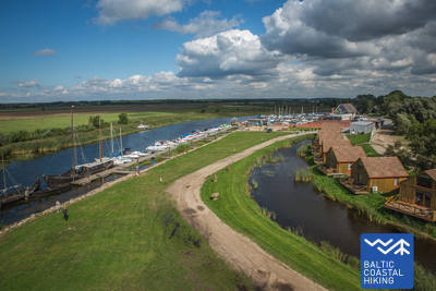
Ventės rage įsikūrusi paukščių žiedavimo stotis su nedideliu švyturiu, nuo kurio galima pamatyti Kuršių marių vandenis. Pakrantės kaimuose sparčiai vystoma turizmo infrastruktūra, nes šias vietas pamėgo jėgos aitvarų sporto entuziastai. Jūrų takas vingiuoja per Dreverną – kažkada buvusį žvejų kaimą, kuriame yra jachtų uostas ir kempingas. Toliau jis 10 km tęsiasi palei istorinį Karaliaus Vilhelmo kanalą, suformuotą XIX a. 7–8 dešimtmetyje ir pavadintą tuomečio Vokietijos kaizerio Vilhelmo Pirmojo garbei. Iš Klaipėdos keltu galima persikelti į Kuršių neriją, kur yra lankytojų pamėgtas Jūrų muziejus ir Delfinariumas. Klaipėda (vok. Memel) – tai buvusi Rytų Prūsijos dalis, todėl čia akivaizdi vokiškos kultūros įtaka. Senamiesčio išplanavimas pasižymi geometriniu tikslumu – akmenimis grįstos gatvelės jį skaido griežtais stačiakampiais.
 Atkarpa 72. Ventė – Dreverna.
Rytine Kuršių marių (įlankos) pakrante
Nuo Ventės rago Jūrų takas Marių gatve (kelias Nr. 2201) eina Klaipėdos kryptimi. Pakrantės kraštovaizdį pagyvina spalvingi pastatai, gausiai išpuošti mediniais ornamentais. Kai kuriuose iš jų įrengtos apgyvendinimo ir maitinimo įstaigos. Nuėjus 5 km Jūrų takas pasisuka Kuršių marių link ir tęsiasi mažu pakrantės taku, kurį supa drėgni pelkiniai miškai. Čia yra poilsiavietės ir apžvalgos bokštai, iš kurių atsiveria gražūs kraštovaizdžiai, matyti 8–10 km nutolę Kuršių nerijos smėlynai. Padarius apie 3 km ilgio lanką, Jūrų takas išeina į ankstesnį kelią ir paėjus maždaug 2 km pasiekia Kintų miestelio centrą, kuriame verta susipažinti su jo architektūros paveldu. Už Kintų maršrutas 5 km ilgio žvyrkeliu kerta gražų, pušimis apaugusį miškingą kopų masyvą. Likus 3 km iki Drevernos kaimo Jūrų takas kerta Svencelę, kuri yra mėgstamiausia Lietuvos buriuotojų ir jėgos aitvarų sporto entuziastų vieta. Čia vyksta naujų, alternatyvių turistinių bazių, kempingų ir maitinimo vietų statyba ir kurorto plėtra. Drevernos kaime Jūrų takas pasisuka Bangų gatve. Čia verta nueiti iki Drevernos uosto, iš kur vėl galima pasižvalgyti per Kuršių marias į nuostabią Kuršių neriją.
 Atkarpa 73. Dreverna – Klaipėda.
Palei karaliaus Vilhelmo kanalą į Klaipėdą
Už Drevernos kaimo Jūrų takas Priekulės keliu (Nr. 2206) kerta Drevernos upę, Klišupę ir Karaliaus Vilhelmo kanalą, už kurio sukasi į kairę ir 9 km kaip medžių lapija padengta alėja vingiuoja palei rytinį istorinio kanalo krantą. Čia įrengtos poilsiavietės ir turizmo informacijos stendai, pasakojantys apie apylinkių gamtinę įvairovę. Dar po 4 km Jūrų takas pasiekia Kairių gatvę, o einant toliau galima grožėtis miesto aplinka. Nuo Jūrininkų prospekto iki Baltijos prospekto Jūrų takas vingiuoja miesto parkų pėsčiųjų takais, kirsdamas Sąjūdžio, Reikjaviko, Draugystės ir kt. parkus. Kirtęs Baltijos prospektą, maršrutas toliau veda Taikos prospekto pėsčiųjų takais ir šaligatviais, o už 3 km pasiekia Biržos tiltą.