


Jūrų takas - Nemuno delta

Nemuno delta
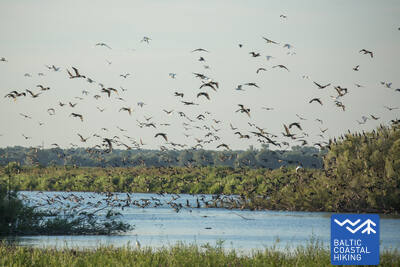
Paukščių stebėjimas užliejamose Nemuno deltos pievose
Rusnė – Šilutė – Kintai – Ventė: 59 km, 3 arba 4 dienos.
Rusnės salą Nemuno deltos regioniniame parke supa Nemuno upės ir jos intakų vandenys. Čia ilsisi migruojantys paukščiai, gyvena kormoranų kolonija. Salos plotas 45 km2, o su žemynu ją jungia tiltas. Rusnės sala yra žemiausia Lietuvos vieta, esanti žemiau jūros lygio. Istoriniame Rusnės centre galima pamatyti autentišką medinę architektūrą, ryškių spalvų pastatus su ornamentais puoštomis langinėmis. Jūrų takas veda per Šilutės miestelį, kur galima pamatyti Rytų Prūsijai būdingą architektūros stilių. Nuo Šilutės iki Kintų Jūrų takas veda žemuma, kurią nuo Nemuno potvynių vandenų saugo polderių pylimų ir kanalų sistema. Netoli nuo Kintų Jūrų takas kerta Minijos upę, ant kurios krantų įsikūręs etnografinis Minijos (Mingės) kaimas. Čia matomas Pajūrio žemumos kraštovaizdis su plačiais raistais ir tvenkiniais.
 Atkarpa 69. Rusnės sala.
Rusnės sala – puiki gyvūnų stebėjimo vieta
Jūrų takas prasideda Rusnės miestelyje, Rusnės saloje. Jis Neringos ir K. Jukštaičio gatvėmis išveda į Rusnės pakrantės promenadą, kuri driekiasi Pakalnės upe – viena iš Nemuno deltos atšakų. Toliau Jūrų takas veda per Rusnės uostą iki pat Pakalnės kaimo, vingiuodamas Rusnės polderių pylimais ir atverdamas gražius vaizdus į spalvingą salos užstatymą bei gluosnius, svyrančius virš Pakalnės vandens. Taip pat už Pakalnės kaimo iki pat Uostadvario švyturio maršrutas veda polderių pylimais, kurie juosia žemiausioje Lietuvos vietoje susiformavusią salą (Rusnėje yra vieta, esanti žemiau jūros lygio), apsaugodami ją nuo apsėmimo. Nuo švyturio iki pat Rusnės miestelio (išskyrus patį Uostadvarį, kur takas eina Atmatos upės kranto polderio pylimu), Jūrų takas veda asfaltuoto kelio pakraščiu. Rusnės miestelyje Kuršmarių ir Taikos gatvėmis galima pasiekti pradinį maršruto tašką. Rusnės sala yra Nemuno deltos regioniniame parke. Polderių pylimai – tai nuostabios vietos, iš kurių salos lygumoje galima stebėti laukinius gyvūnus: stirnas, briedžius ir paukščius pavasario bei rudens migracijų metu.
 Atkarpa 70. Rusnė – Šilutė.
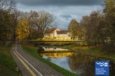
Šilutė – autentiškas žavingas miestelis
Rusnės miestelyje Taikos ir Kuršmarių gatvėmis Jūrų takas veda Rusnės tiltu per Atmatos upę, kuri yra viena iš Nemuno deltos atšakų. Toliau Jūrų takas driekiasi pėsčiųjų taku, atskirtu nuo kelio, ir tęsiasi iki Šilutės. Šiek tiek kelio iki Šilutės teks eiti kelkraščiu. Šilutėje pereisite istoriniu tiltu per Šyšos upę. Rusnės gatvė, jungianti Rusnės salą su Šilute, veda tiesiai į miestelio centrą. Iki pat Šilutės Jūrų takas priskiriamas Nemuno deltos regioniniam parkui, kurio apylinkėse kiekvieną pavasarį patvinsta Nemuno žemupio lygumos – dabartinės ganyklos ir pelkiniai miškai (Žalgirių miškas).
 Atkarpa 71. Šilutė – Ventė.
Per Nemuno regioninį parką
Klaipėdos ir Aukštumalės gatvėmis Jūrų takas išeina iš Šilutės miesto Kintų kryptimi (kelias Nr.4217), veda polderių pylimu (nuo jo gerai matoma Nemuno deltos žemuma, kuri pavasarį patvinsta), vingiuoja žvyrkeliu ir vėl sugrįžta į Aukštumalės gatvę (Nr.4217). Nuėjus apie 6 km ties Rūgailių kaimu sankryžoje Jūrų takas daro lankstą į kairę Minijos kryptimi ir po 1,5 km sukasi į dešinę, vėl sugrįždamas į kelią Šilutė–Kintai. Aukštu ir ilgu tiltu maršrutas kerta Minijos upę ir Kintų tvenkinius. Iš čia atsiveria vienas neįprasčiausių Lietuvos pakrantės kraštovaizdžių su plačia žemumos ir vandenų panorama. Prieš Povilų kaimą Jūrų takas pasuka į kairę ir toliau apie 5 km vingiuoja per ganyklas, kur migracijos metu galima stebėti paukščius. Toliau maršrutas pasuka į pamario kelią (Marių gatvė, kelias Nr. 2201), kuriuo po 5 km pasiekia Ventės ragą. Nuo šios peizažinės kelio atkarpos atsiveria vaizdai į kitapus Kuršių marių (jų plotis čia 8–9 km) esančią Kuršių neriją. Pėsčiuosius džiugina ir buvusios žvejų gyvenvietės, ir įvairių spalvų, dekoratyviniais elementais papuošti pastatai. Atkarpa eina per Nemuno deltos regioninį parką.