


Metsa matkarada - Sobilik vaegnägijatele


 1. päev. Riia vanalinn ‒ Baltezers.
Läbi Riia ‒ UNESCO maailmapärandi meistriteos
Metsa matkaraja alguspunkt Lätis asub Riia vanalinnas, Raekoja platsil. Rada kulgeb piki Kaļķu tänavat, mööda Vabadussambast, läbi Vērmane aia ja jätkub Tērbata (Tartu) maanteel, ületab Zemitāni raudteejaama jalakäijate silla ning suundub Biķernieki ja Šmerlise metsadesse. Tee läbib Läti etnograafilise vabaõhumuuseumi ja kulgeb mööda kergliiklusteed Baltezersi külani.
The "Feel Jugla" Walking Trail

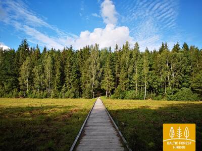
Jugla järve kirdeossa Juglas on rajatud 250-meetrine puidust laudtee (üks suund) vaateplatvormiga Jugla järvele, pink, 20 kombatavat ruumireljeefi, mis kujutavad järve ja selle ümbruse iseloomulikke loomaliike ning teave punktkirjas. See on ligipääsetav ratastoolis inimestele. Koht asub Mežtaka rajast 0,5 kilomeetri kaugusel.


Taktilais Brīvības piemineklis
Avati Läti sünnipäeval – 18. novembril 2022 – Brīvības väljakul Kārlis Zāles loodud originaali vastas ja avati 18. novembril 1935. Selle erilise pronksist miniatuuri lõi skulptor Ivars Miķelsons mõõtkavas 1:50.


83. päev. Paplatelė – Plateliai.
Ümber Žemaitija rahvuspargi suurimate järvede
Esimesed 3,5 km mööduvad kaunites okasmetsades, mis katavad Žemaitija kõrgustiku nõlvu. Kuni Külma sõja muuseumini kulgeb Metsa matkarada Plokštinė tundmusrajal. Pärast muuseumi suundub rada Plokštinė tee kõrval kergliiklusteele. Plateliai järvele lähenedes laskub matkarada järvemadalikule. Teel nr 3202 (Malūno tänaval) keerab Metsa matkarada vasakule, kagu suunas ning 300 m hiljem paremale, jõudes u poole kilomeetri pärast Ilgio Ežero tänavale. Järgmise 5,5 km jooksul teeb matkarada laia kaare ümber Ilgise ja Beržorase järvede, kuni saabub Beržorase külla. Külast väljudes kulgeb tee 2 km mööda Plungėse tänavat ja jõuab seejärel Plateliai alevisse. Rada teeb nüüd hoogsa looke, siirdudes Ežero tänava ja Šeirė õpperaja kaudu Plateliai järve ranna suunas. Rannast suundub Metsa matkarada piki Ežero, Naujoji ja Žemaičių Kalvarijose tänavaid tagasi alevi keskusesse.
Šeire's Educational Trail
Rada on ligikaudu 7 kilomeetrit pikk, kuid seal on ratastoolis inimestele ligipääsetav vaateplatvorm, kust avaneb vaade Plateliai järvele ja selle saartele. Plateliai asub Žemaitija rahvuspargis. Infotahvlil on puutetundlik kaart järvest koos saartega, mis võimaldab nägemispuudega inimestel seda uudistada. Parkla asub siin: GPS 56.048355, 21.826901. See asub Mežtaka raja kõrval.


Plokštines militārā pilsēta
Alates 1993. aastast haldab endist Nõukogude armee rajatist Samogitia rahvuspargi direktoraat. Paljud sõjaväelinnaku hooned lammutati 2017. aastal nende lagunenud seisukorra tõttu. Hetkel on alale jäänud ligikaudu 10 hoonet, mida külastajad saavad vaadata väljastpoolt. Seal on infotahvlid, mis räägivad endistest hoonetest ja nende otstarbest. Paigaldatud on kombatav stend - kaart, mis tutvustab hooneid, nende asukohta ja funktsioone.


84. päev. Plateliai – Salantai.
Pajūrise madaliku poole
Metsa matkarada kulgeb 6 km Plateliai–Salantai tee (nr 2302) ääres. Siit avanevad hurmavad vaated Pajūrise madalikule ja sellega piirnevale Žemaitija kõrgustiku lääneosale. Gintališkė külas keerab rada vasakule, et suunduda edelasse viivale teel nr 3216. 2,4 km pärast teeb matkarada pöörde paremale, kust rada viib metsa. Nõukogude ajal oli siin raketibaas, sellest ajast annab tunnistust ka betoonplaatidega kaetud tee. Nüüd keerab Metsa matkarada 1,4 kilomeetriks Plungė–Salantai teele (nt 169), kuni keerab vasakule. Seejärel viib rada mööda väikest külateed Salantai suunas. Alevikeskusesse kulgeb matkarada piki Žemaitėse ja M. Valančiause tänavaid. Selle päeva teekonna esimene pool möödub Žemaitija rahvuspargis, teine aga Salantai regionaalpargis.
Šeire's Educational Trail
Rada on ligikaudu 7 kilomeetrit pikk, kuid seal on ratastoolis inimestele ligipääsetav vaateplatvorm, kust avaneb vaade Plateliai järvele ja selle saartele. Plateliai asub Žemaitija rahvuspargis. Infotahvlil on puutetundlik kaart järvest koos saartega, mis võimaldab nägemispuudega inimestel seda uudistada. Parkla asub siin: GPS 56.048355, 21.826901. See asub Mežtaka raja kõrval.
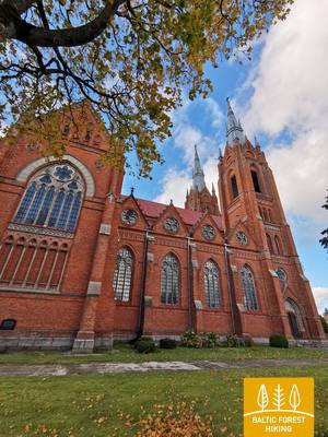
92. päev. Snēpele – Kuldīga.
Kuldīga – Kuramaa võluvaim keskaegne linn
Snēpele peatänavalt suundub Metsa matkarada teele nr V1294 ja 300 meetri pärast, Ķepšu järve kohal, keerab rada paremale, väiksele külateele. Tee viib Slipiņciemsi ning ületab seejärel tammi kaudu Sprincupe jõe. Siis võtab rada suuna Pelči poole. Pelči küla lähedal lookleb Metsa matkarada Pelči tammitiikide kallastel, viib Kuldīga–Pelči teele (V1293) ja sealt edasi Kuldīga aianduspiirkondadesse, mis kannavad nimesid “Kurzemīte” ja “Rumba”, kuni jõuab Venta jõe kallastele ja Kuldīga ringteele. Järgmised 2,4 km, kuni vana kivisillani, mööduvad ilusal Venta jõe äärsel kallasrajal, kus väiksed puust sillakesed ja purded viivad üle ojade ja niiskemate kohtade.
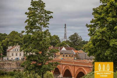
The walking trail along the Venta River in Kuldīga
Rada kulgeb mööda Venta jõe vasakut kallast Kuldīga linnaaiast kuni uue Kuldīga sillani, läbides 2,4 kilomeetrit. Raja äärde on paigutatud puhkekohad ja infotahvlid. See on ratastoolis inimestele ligipääsetav tänu oma siledale pinnale, mis koosneb peenest kõvast kruusast, kuigi mõned lõigud võivad kallakute tõttu abi vajada. Rada on lai ning väikeste ojakurgude ristuvatele kohtadele on rajatud puidust laudteed ja sillad. See Mežtaka raja lõik kulgeb mööda Kuldīga promenaadi rada. Saadaval on kohandatud tualetid. GPS-i juurde on rajatud parkla: 56.973354, 21.977798.


 93. päev. Kuldīga – Renda.
Venta jõe org ja Riežupe looduspark
Pärast pikka kivisilda, mis viib matkaja üle Venta jõe, kulgeb Metsa matkarada lühikest aega Venta jõe paremkaldal, mida liigestavad jäärakud, keerab seejärel Krasta tänavale ja Vetklīnika–Paleja teele, ning viib läbi Kalnmuiža metsa, Riežupe ja suure Renda metsa edasi Mazrenda küla poole. Maastik on siin tasane, sest tegemist on Kursa madalikul asuva Pieventa tasandikuga. Mazrendas kulgeb Metsa matkarada üle liiva-kruusakarjääri ning jõuab Kuldīga tänavat kaudu Renda külla. Selle päeva teekond kulgeb esiti Venta jõe oru looduskaitsealal ja hiljem Riežupe looduspargi territooriumil.
Audio guide "Through Mežtaka in Kuldīga for People with Visual Impairments"
2024. aastal on valminud audiogiid pealkirjaga "Läbi Mežtaka Kuldīgas nägemispuudega inimestele". See algab Kuldīga vaatetorni juurest, ületab vana telliskivisilda üle Venta jõe ja aitab kasutajatel tutvuda Kuldīga promenaadiga mööda Ventat. Teave vaatetorni ja selle läheduses on punktkirjas. GPS-i juurde on rajatud parkla: 56.973354, 21.977798.


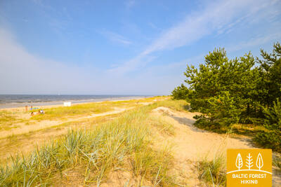
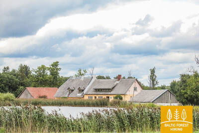
100. päev. Bigauņciems - Dubulti.
Jūrmala ajaloolises kuurordis
Bigauņciemsi külast paistab kogu Jūrmala rannik justkui peopesal. Päeva esimene pool möödub Ķemeri rahvuspargi territooriumil. Jaunkemeri ja Dubulti vahelisel lõigul on võimalik kõndida Liivi lahe kõige laiemal liivarannal. Rada viib läbi Jūrmala ajaloolise kuurordi, mis on Läti pikim linn. Tasub arvestada, et ilusatel suvepäevadel on Jūrmala rannas väga palju rahvast.
The Dubulti Coastal Dunes Trail
Aastal 2024/2025 luuakse Jūrtaka raja lõik, mis kohandatakse spetsiaalseks marsruutiks nägemispuudega inimestele.


101. päev. Dubulti - Lielupe - Bulduri.
Läti populaarseimad supelrannad
Ranniku matkaraja lõigul Dubulti ja Lielupe vahel paikneb Liivi lahe kõige laiem liivarand – oma lugematute rannakohvikute ja puhkamisvõimalustega on see Jūrmala kuurortlinna suurim väärtus ja tõmbenumber. Rannaäärsetes luitemetsades on tihe rajavõrgustik, mis sobib hästi jalutamiseks ja kepikõnni harrastamiseks. Lielupe ranna ja Jūrmala vabaõhumuuseumi vaheline matkaraja lõik kulgeb Ragakāpa looduspargi territooriumil. Buldurisse saab mugavalt tagasi kõndida mööda Bulduri avenüüd või 5. liini.
The Dubulti Coastal Dunes Trail
Aastal 2024/2025 luuakse Jūrtaka raja lõik, mis kohandatakse spetsiaalseks marsruutiks nägemispuudega inimestele.