


Ranniku matkarada - Curonian lagoon

Coastline of Curonian lagoon

Rannikumaastikud, kalurikülad ja Klaipėda
Ventė – Dreverna – Klaipeda: 50 km, 2 päeva.
Ventė neemel asub väikese tuletorniga ornitoloogiajaam, kust paistab Kura lahe vesi. Turismiinfrastruktuur areneb rannikulinnades, kuna see on populaarne surfikoht. Läänemere ranniku matkatee lookleb läbi Dreverna, endise kaluriküla jahisadama ja laagripaigaga. Järgmised 10 km kulgeb rada mööda tööstuspärandit – 1860. ja 1870. aastatel ehitatud Kuningas Wilhelmi kanalit, mis sai nime tollal valitsenud Saksa keisri Wilhelm I auks. Klaipėdast saavad matkajad sõita praamiga Kuramaale, kus asub populaarne meremuuseum. ja delfinaarium asub. Klaipėda (ajaloolise nimega Memel) kuulus kunagi Ida-Preisimaa koosseisu ja oli seega mõjutatud saksa kultuurist. Klaipėda vanalinn on ainulaadne oma planeerimise geomeetrilise täpsusega, kusjuures kõik ristmikud on täiuslikud täisnurgad.
 72. päev. Ventė – Dreverna.
Along the eastern coast of the Curonian Lagoon
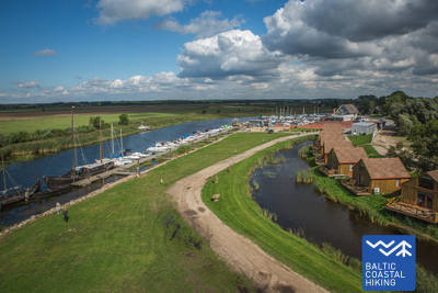
Ventė neemest kulgeb Balti ranniku matkatee mööda Marių tänavat (maantee nr 2201) Klaipėda poole. Rannikumaastik ärkab ellu värviliste hoonetega, millel on rikkalikud puidust kaunistused. Mõned neist asuvad majutus- ja toitlustusasutustes. 5 km pärast pöörab rada Kura lahe poole ja läheb edasi mööda kitsast rannarada läbi soometsa. Umbes 8–10 km kaugusel asuvad puhkekohad ja vaatetornid, kust avaneb kaunis vaade Kuramaa liivaluidetele. Pärast umbes 3 km pikkust tiiru naaseb Balti ranniku matkatee oma eelmisele kursile ja jõuab umbes 2 km kaugusel Kintai küla keskusesse, kus tasub võtta aega ja tutvuda selle arhitektuuripärandiga. Pärast Kintaid kulgeb Balti ranniku matkatee läbi 5 km kaunite männiga kaetud luidete. 3 km enne Dreverna küla läbib rada Svencelė, Leedu populaarseim purje- ja lohesurfipaik. Kohapeal käib vilgas kuurordiarendus, sest ehitatakse uusi alternatiivseid turismimajutuskohti, telkimispaiku ja toitlustusasutusi. Dreverna külas keerab rada Bangų tänavalt. Tasub laskuda Dreverna sadamasse, kust paistab üle Kura lahe majesteetlik Kuramaa.
 73. päev. Dreverna – Klaipėda.
Along King Wilhelm Canal to Klaipėda
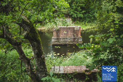
Dreverna külast kulgeb Balti ranniku matkatee mööda Priekulė teed (nr 2206), et ületada Dreverna jõgi, Klišupė jõgi ja Kuningas Wilhelmi kanal, misjärel pööratakse vasakule ja järgmised 9 km see viib läbi lopsakate puudega ääristatud sõiduraja mööda ajaloolise kanali idakallast. Tee ääres on erinevad puhkekohad ja turismiinfostendid, mis selgitavad kohaliku looduskeskkonna mitmekesisust. Rada jõuab Kairių tänavale 4 km hiljem ning raja järgmine lõik kulgeb läbi linnapiirkonna. Jūrininkų prospektast Baltijos prospektaseni kulgeb Balti ranniku matkatee läbi linnaparkide, läbides Reformiliikumise (Sąjūdžio), Reykjavíki, Sõpruse (Draugystės) ja teiste parkide jalgteed. Balti prospektast ületades kulgeb rada mööda Taikos prospekti jalakäijate radu, jõudes 3 km hiljem Birža sillani.