


Ranniku matkarada - Nemunas delta

Nemunas delta

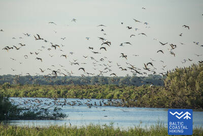
Linnuvaatlus Nemunase delta lamminiitudel
Rusnė – Šilutė – Kintai – Ventė: 59 km, 3 või 4 päeva.
Nemunase delta regionaalpargis asuv Rusnė saart ümbritseb Nemunase jõe ja selle jaovee vesi. Rändlinnud peatuvad siin puhkamiseks ja see on koduks suurte kormoranide kolooniale. Saare pindala on 45 km 2 , seda ühendab sild mandriga. Rusnė saar on Leedus kuulus selle poolest, et asub allpool merepinda. Rusnė ajaloolises keskuses on autentne puitarhitektuur, erksavärvilised hooned koos mitmevärviliste aknaluukide ja kaunistustega. Balti ranniku matkatee kulgeb läbi Šilutė küla, mis iseloomustab Ida-Preisimaale iseloomulikku arhitektuuristiili. Šilutėst Kintaini kulgeb rada mööda madalat tasandikku, mida Nemunase delta tulvavete eest kaitsevad poldrid — tammide ja kanalite süsteem. Mitte kaugel Kintaist läbib Balti ranniku matkatee Minija jõge, mille kaldal asub etnograafiline küla (Mingės). Siin laieneb mereäärne madalikmaastik silma ees suurte märgalade ja tiikidega.
 69. päev. Rusnė Island.
Rusnė Island — excellent location for wildlife observation
Balti ranniku matkatee saab alguse Rusnė külast Rusnė saarel. Rada viib läbi Neringose tänava ja K. Jukštaičio tänava Rusnė küla rannaäärsele kõnniteele, mis kulgeb mööda Pakalnė jõge – Nemunase delta üht suurimat jaotikku. Läänemere ranniku matkatee viib edasi läbi väikese Rusnė sadama, uidates läbi Rusnė poldritammide kuni Pakalnė külani, pakkudes imelisi vaateid saare värvilisele arhitektuurile ja Pakalnė vete üle ulatuvatele pajupuudele. Peale Pakalnė küla kuni Uostadvarise tuletornini kulgeb marsruut valdavalt Rusnė poldritammidele, mis ümbritsevad ja põimivad madalat saart (saarel on koht, mis asub allpool merepinda), et kaitsta seda üleujutuste eest. Tuletornist Rusnė külani kulgeb Balti ranniku matkatee mööda kõvakattega teed (välja arvatud Uostadvarise külas, kus rada kulgeb Atmata jõe kaldal asuval poldritammil). Rusnė külas kulgeb rada mööda Kuršmarių tänavat ja Taikose tänavat tagasi alguspunkti. Rusnė saar asub Nemunase delta regionaalpargis. Poldritammid sobivad suurepäraselt madalate tasandike metsloomade vaatlemiseks – siin võib näha metskitsi, põtru ja linde kevad- ja sügisrändel.
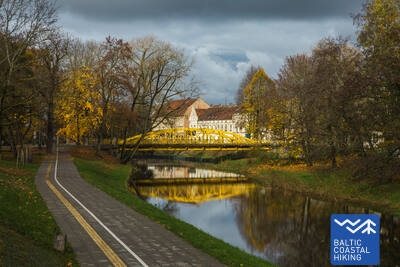
 70. päev. Rusnė – Šilutė.
Šilutė – a charming authentic town
Rusnė külas kulgeb Balti ranniku matkatee mööda Taikose tänavat ja Kuršmarių tänavat, ületades Nemunase delta jaotusala Atmata jõe üle Rusnė silla. Seejärel kulgeb rada eraldi sõidurajana mööda teeserva, jätkates edasi Šilutėsse. Veidi enne Šilutesse jõudmist peavad matkajad kõndima teeservas. Šilutes ületate Šyša jõe ajaloolise silla. Rusnė tänav, mis ühendab Rusnė saart ja Šilutėt, viib teid otse linna keskmesse. Kuni Šilutėni kulgeb Balti ranniku matkatee läbi Nemunase delta regionaalpargi, kus kevaditi ujutavad üle suured alad Nemunase jõe alamjooksul – tänapäeval on need alad põllumaa ja soometsad (Žalgiriai mets).
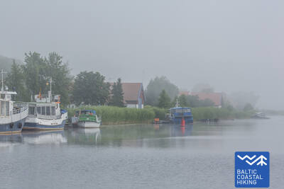
 71. päev. Šilutė – Ventė.
Through Nemunas Delta Regional Park
Mööda Klaipėdos tänavat ja Aukštumalės tänavat väljub Balti ranniku matkatee Šilutė linnast Kintai suunas (tee nr 4217), järgides korraks poldritammi tippu (pakkudes head vaadet Nemunase delta madalikule, mis üleujutab kevadel), uidub see mööda maanteed ja pöördub tagasi Aukštmalės tänavale (tee nr 4217). Vähem kui 6 km pärast ristub Rūgailiai küla ristmikul Läänemere ranniku matkatee vasakule Minija poole ja 1,5 km pärast paremale, pöördudes tagasi Šilutė–Kintai maanteele. Balti ranniku matkatee läbib üle kõrge ja pika silla Minija jõe ja Kintai karpkalajärved. Siit avaneb teile üks suurejoonelisemaid vaateid Leedu rannikule koos laiaulatusliku panoraamiga madalikule ja vetele. Enne Povilai külla jõudmist pöörab rada vasakule, mis kulgeb umbes 5 km läbi põllumaa, kus saab rändeperioodil linde vaadelda. Seejärel keerab Balti ranniku matkatee rannaäärsele teele (Marių tänav, tee nr 2201), mis viib 5 km kaugusel asuvale Ventė neemele. Sellelt maalilisel marsruudilõigul avaneb avar vaade Kuramaale üle Kura lahe (lahe laius on siin 8–9 km). Matkajad saavad nautida ka endisi kalurikülasid oma värviliste kaunistatud hoonetega. See rajalõik on osa Nemunase delta regionaalpargist.