


Baltic Coastal Hiking trail - The Curonian spit

The Curonian spit
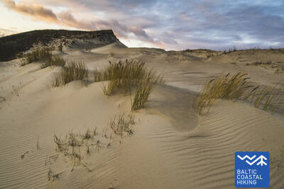
The Curonian Spit National Park: the highest dunes in Northern Europe
Nida – Pervalka – Juodkrantė – Smyltinė – Klaipėda: 59 km, 3 days.
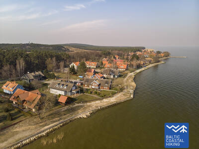
The Curonian Spit National Park is located on a long, sandy strip of land in between the waters of the Baltic Sea and the Curonian Lagoon. An almost 50 km long sandy beach stretches along the western side of the dunes of the Curonian Spit, the coastline of the Curonian Lagoon is mottled with shallow, reed-filled bays and the surrounding area is an important location for rest, feeding and nesting of birds. Through the ages, the wind-swept sands have occasionally buried homesteads and villages set on the seafront. Pine tree stands have been planted on the dunes in the hopes of stopping the migrating sands. Smiltynė is home to the popular Sea Museum and Dolphinarium.
 Section 64. Nida – Pervalka.
Along the coast of the Curonian Lagoon
The Baltic Coastal Hiking Route starts in the center of Nida, by the port. In Nida, the trail winds along the Curonian Lagoon walkway which offers beautiful views of the expansive waters all the way to Rusnė Island on the east coast of the Curonian Lagoon. Nida features the typical architecture of the Curonian Spit region — one-storey wooden buildings with tile or reed roofs and window shutters painted blue and white. From Nida to Bulvikis Cape (shortly before the cape there is an abandoned runway), the Baltic Coastal Hiking Route winds through single-track forest trails up and down the pine-covered dunes, occasionally coming out onto beachside meadows with scarce vegetation. Rest spots and bird watching towers are available along the trail. The next section features unique open seaside meadows covered in lichens and vegetation characteristic to the Curonian Spit. The Baltic Coastal Hiking Route follows the coastal walkway in the village of Preila. It then winds through forest trails, briefly also following a pedestrian/cyclist lane and coastal paths, eventually reaching Pervalka. This section leads through the Curonian Spit National Park.
Section 65. Pervalka – Juodkrantė.
Along the most majestic sand dunes in Northern Europe
Having departed Pervalka, the Baltic Coastal Hiking Route follows a pedestrian path to cross the Curonian Spit in an east–western direction, arriving at the coast of the Baltic Sea. The next section of 13 km leads along a beautiful, sandy beach protected by high and steep sand dunes on the east. It is called the protective dune ridge and it has been man-made in order to protect the inland from the movement of sand. Entering Juodkrantė, the Baltic Coastal Hiking Route turns eastward and crosses the Curonian Spit once again over wooded and steep dunes, to reach the Curonian Lagoon coast. The Baltic Coastal Hiking Route briefly coincides with the Hill of Witches trail. It then follows the Juodkrantė beachside walkway to the port. This section leads through the Curonian Spit National Park.
 Section 66. Juodkrantė – Klaipėda.
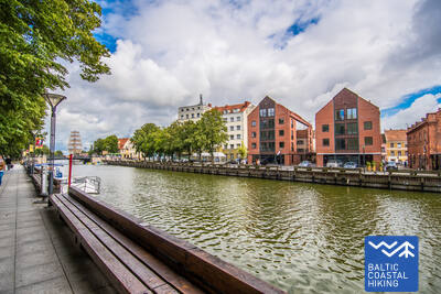
Klaipėda — Lithuania’s gate to the sea
Having left the Juodkrantė beachside walkway, the Baltic Coastal Hiking Route crosses the Curonian Spit in a southeast–northwest direction leading along single-track forest trails that wind through the steep, pine-covered dunes until it eventually comes back out onto the coast of the Baltic Sea. For the next 9 km, the Baltic Coastal Hiking Route follows the coastline along sandy beaches. The steep foredune on the eastern side protects the inland from the moving sand. After Alksnynė village (not seen from the beach), the Baltic Coastal Hiking Route turns eastward, crossing a hillock covered in Pinus mugo pines and a World War II German army base, eventually approaching the coast of the Curonian Lagoon. Then the trail winds across the ridges of pine-covered dunes, providing regular views of Klaipėda Port. The route between the New and Old Ferry Port first follows a single-track path, and later a beachside walkway. Having crossed the Curonian Lagoon from the Old Ferry Port, the Baltic Coastal Hiking Route arrives in the center of Klaipėda where it follows Danės Street to the Birža Bridge. The section until Smiltynė leads through the Curonian Spit National Park.