


Baltischer Wald-Wanderweg - Riga and Riga Region

Das Rigaer Umland
DAS MALERISCHE UMLAND DER KONTRASTE - VON MITTELALTERLICHEN TÜRMEN ZU EINSAMEN WÄLDERN
Altstadt von Riga – Ramkalni, 56 km, 1.–3. Tag
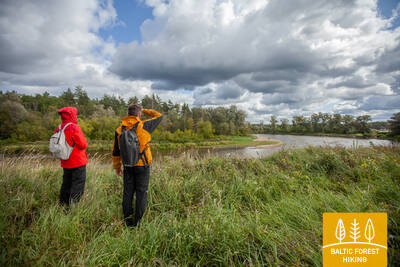
Riga ist von herrlichen Kiefernwäldern umgeben, die man schon nach ein paar Stunden per pedes erreicht. Der Wanderpfad führt durch bewaldete Dünen, entlang des Flusses Gauja und über eine historische Poststraße, die schon vor Jahrhunderten dem Transport von Menschen und Gütern diente. Im Frühsommer blühen unzählige Pechnelken auf den weiten Wiesenflächen links und rechts der Wanderroute.
Die eindrucksvollsten sehenswürdigkeiten: Altstadt von Riga – UNESCO-Weltkulturerbe, Freiheitsdenkmal und Lettische Nationaloper, Rigaer Zentralmarkt – historische Zappelinhallen, Kultur- und Naturerbe des Vermanes-Gartens, Jugendstil auf der Terbatas Straße, Ethnografisches Freilichtmuseum Lettlands, Wasserpumpstation Baltezers – Industriedenkmal, Künstlergarten von Anna Ludina, Jagdschloss in Incukalns, Jagdpfad und Velnala-Höhle in Incukalns.

 1. Etappe. Altstadt von Riga – Baltezers.
Durch Altstadt von Riga – UNESCO-Weltkulturerbe
Der Baltische Wald-Wanderweg (lettisch Mežtaka) beginnt am Rathausplatz im Herzen der Rigaer Altstadt. Die ersten Kilometer verläuft der Weg entlang der Kaļķu Straße und am Freiheitsdenkmal vorbei, durch den Vērmanes-Garten und die historische Tērbatas Straße. Weiter führt die Strecke über eine Fußgängerbrücke am Zemitānu-Bahnhof und durch den städtischen Biķernieku-Wald und den Šmerļa-Wald. Der Wanderweg durchquert den Stadtbezirk Jugla, vorbei am ethnographischen Freilichtmuseum Lettlands und erreicht über Fußgänger- und Fahrradwege die Ortschaft Baltezers.
2. Etappe. Baltezers – Vangaži.
Unterwegs auf der alten Dorpater Chaussee, entlang der Gauja und vieler Seen
Durch einen Tunnel unterquert der Baltische Wald-Wanderweg die Fernverkehrsstraße Via Baltica und läuft weiter an ruhig gelegenen Privathäusern und dem Kleinen Baltezers-See entlang. Dann biegt der Wanderweg östlich ab und folgt dem Kanal, der den Baltezers-See mit dem Fluss Gauja verbindet. Auf der Strecke zwischen Garkalne und Āņi wandert man an wunderschönen Wiesen mit roten Pechnelken-, weißen Margeriten- und gelben Hahnenfußblüten vorbei. Früher verliefen hier die mittelalterlichen Handelswege und die Gauja konnte man bei Iļķene mit einer Fähre überqueren. Hinter der Siedlung Āņi verläuft der Baltische Wald-Wanderweg sowohl durch waldbedeckte als auch eng besiedelte Gebiete und erreicht über die Gaujas Straße die Ortschaft Vangaži.
3. Etappe. Vangaži – Rāmkalni.
Entlang des Jagdschlosses Inčukalns zum Nationalpark Gauja
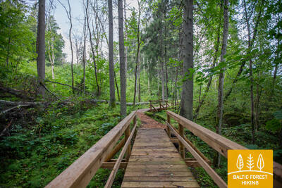
Hinter Vangaži schlängelt sich der Baltische Wald-Wanderweg auf engen Waldpfaden und an der Evangelisch-Lutherischen Kirche Vangaži sowie den Werwolf-Kiefern vorbei. Richtung Jagdschloss folgt man der sogenannten Katharinenstraße, benannt nach Zarin Katharina II. Der Wanderweg durchquert ein Wald und setzt sich hinter dem Jagdschloss auf dem Jägerpfad fort. Hier bieten sich den Wanderen Ausblicke in die Schluchten des Gauja-Urstromtals mit seinen ausgeprägten Oberflächenreliefs In einer der Schluchten befindet sich die Velnala-Höhle von Inčukalns, in der Gegend sind auch mehrere Altarme der Gauja zu sehen. Der Wanderweg führt nun weiter über Uferwiesen und überquert die Schnellstraße Murjāņi - Valmiera, an deren Rand sich der Freizeitpark „Rāmkalni“ befindet.