


Baltischer Wald-Wanderweg - Valley Dubysa river

Entlang den Ufern des Dubysatals
Die bunten Wiesen des malerischsten Flusstals Litauens
Vilkija – Padubysys – Ariogala – Kirkšnovė – Kaulakiai – Šiluva – Tytuvėnai – Aukštiškiai – Dengtiltis: 141 km, 6 oder 7 Tage.
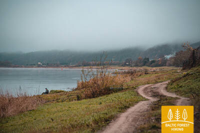
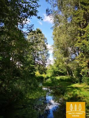
Eineinhalb Tage lang durchquert der Wald-Wanderweg den Regionalparks von Dubysa (Dubysos regioninis parkas), wo am Ufer des Flusses Burghügel, historische Kirchen und andere kulturhistorische Zeugnisse zu sehen sind. Dubysa ist ein wunderschöner Fluss, der aufgrund seiner schnellen Strömung bei Naturliebhabern beliebt ist. Dubysa ist seicht, das Flusswasser ist klar und an seinen sandigen Ufern gibt es Campingplätze und Siedlungen. Der Wald-Wanderweg führt durch die historischen Siedlungen Betygala, Ugionius und Šiluva bis zum Regionalpark Tytuvėnai. Der größte Naturwert des Parks sind die Seen, die von Feuchtgebieten umgeben sind - die ein wichtiger Lebensraum für viele Tiere und Vögel, darunter Tausende von Kranichen sind. Die Kleinstadt Tytuvėnai ist für ihr im 17. Jh. erbauten Kloster und Kirche der Bernhardiner bekannt. Šiluva ist ein wichtiger Wallfahrtsort für Katholiken.
 67. Etappe. Vilkija – Padubysys.
Zwischen den Tälern zweier Flüsse - der Nemunas und der Dubysa
Der erste Kilometer des Wald-Wanderweges führt am Ufer des Nemunas entlang, biegt dann von der Straße Kaunas – Jurbarkas (Nr.141) ab und führt auf einem Fußgänger- /Radweg zum Burghügel Ringovė. Rechts nach Norden abbiegend, überquert der Wald-Wanderweg ein kleines Waldmassiv (entomologisches Naturschutzgebiet zum Insektenschutz) und folgt weiter der Straße Nr. 1929. Nach 2 km biegt der Wald-Wanderweg nach links ab und führt über landwirtschaftliches Land. Vor dem Dorf Lazduoniai durchquert er das tiefe Tal des Flusses Lazduona, folgt 0,2 km der Straße Nr. 1917 und biegt dann rechts nach Nordwesten ab, bis er das tiefe und breite Dubysa-Tal erreicht. Auf den nächsten 2 km schlängelt sich der Wald-Wanderweg entlang einer Landstraße am linken Ufer der Dubysa, wo seltene Gehöfte zu sehen sind. Das Flusswasser ist im Sommer klar, die Strömung ist ruhig und wird nur von den Resten des ehemaligen Mühlendamms unterbrochen. Schließlich windet sich der Wald-Wanderweg am steilen Ufer des Dubysa-Tals hinauf und erreicht das Ziel dieses Abschnitts.
 68. Etappe. Padubysys – Ariogala – Kirkšnovė.
Auf dem Weg zu einer der ältesten Siedlungen Litauens – Ariogala
Der Wald-Wanderweg windet sich am steilen Ufer des Dubysa-Tals entlang, durchquert auf einer Länge von 2,5 km einen kleinen Wald und führt 4 km weiter bis Čekiškė durch eine Gegend, wo im Sommer ausgedehnte Maisfelder gedeihen. Eine ähnliche Landschaft ist auf den nächsten 9 km zu sehen, bis der Wald-Wanderweg die Schnellstraße Kaunas-Klaipėda (A1) über die Brücke überquert. Etwa 1,5 km weiter, vor dem Dorf Gėluva, steigt der Wald-Wanderweg in das tiefe Dubysa-Tal hinab und über kleine Pfade und ruhige Landstraßen, die sich entlang der Flussbiegungen schlängeln und weite Ausblicke auf die Stadt Ariogala an der Spitze des Tals freigeben. Entlang der Dubysos- und Gedimino-Straßen windet er sich bis zur zentralen Straße der Stadt, der Vytauto-Straße. Weiter entlang der Plento-Straße erreicht der Wald-Wanderweg 5 km vom Zentrum entfernt den Punkt, an dem Sie zum Ende des Abschnitts abbiegen müssen - Kirkšnovė-Teich (weitere 0,2 km).
69. Etappe. Kirkšnovė – Kaulakiai.
Durch den Regionalpark Dubysa
Ungefähr 0,5 km hinter Kirkšnovė biegt der Wald-Wanderweg von der Landstraße Ariogala – Betygala (Nr. 3504) nach links ab und weiter zum Ziel auf der Straße Raseiniai-Baisogala (Nr. 225), die sich entlang der Biegungen des Flusses Dubysa schlängelt, wo die Auewiesen von Waldmassiven und kleinen Dörfern abgelöst werden. An manchen Stellen gibt es weite Ausblicke auf die hohen Ufer und Burghügel des Dubysa-Tals. In diesem Abschnitt gibt es ein ausgeprägtes Relief – der Wald-Wanderweg verläuft über die steilen Hänge der Ufer auf und ab und bietet ein ungewöhnliches Wandererlebnis. Dies ist ein Abschnitt für Wanderer - „Gourmets“!

70. Etappe. Kaulakiai – Šiluva.
Das Dubysa-Tal und die höchste Eisenbahnbrücke Litauens
Entlang der Straße Raseiniai – Baisogala (Nr. 225) und ihrem Bürgersteig durchquert der Wald-Wanderweg das tiefe Dubysa-Tal und biegt beim Dorf Ginčaičiai rechts ab. Nach einem weiten Bogen durch die umliegende Landschaft führt er nach 6 km auf die Straße Raseiniai-Šiluva (Nr. 148) und nach etwa 3 km wieder durch das Dubysa-Tal und erreicht dann das Dorf Kušeliškė. Auf weiteren 5,5 km verläuft der Wald-Wanderweg entlang der Straße Kušeliškė – Lyduvėnai (Nr. 3516), wo in der Ferne die berühmte und malerische Eisenbahnbrücke Lyduvėnai zu sehen ist. An der Straßenbiegung vor der Straßenbrücke von Dubysa biegt der Wald-Wanderweg rechts nach Nordosten ab und erreicht auf der Straße Nr. 3544 nach 9 km Šiluva, nach weiteren 0,8 km – das Stadtzentrum. In dieser Etappe wird das Gelände allmählich ausgeprägter, da es in das Gebiet führt, in dem sich das Dubysa-Tal mit dem südlichen Teil des östlichen Hochlands Žemaitija abwechselt. Der Wegabschnitt nach Lyduvėnai führt über oder entlang des Regionalparks Dubysa, aber Šiluva ist bereits Teil des nächsten – des Tytuvėnai-Regionalparks.
71. Etappe. Šiluva – Tytuvėnai – Aukštiškiai.
Durch den Regionalpark Tytuvėnai
Von Šiluva nach Tytuvėnai führt ein 7 km langer asphaltierter Fußgänger-/Radweg entlang der Straße. Der Wald-Wanderweg durchquert das Zentrum von Tytuvėnai entlang der Straßen Šiluvos und Maironio, biegt in die Miško-Straße ab und führt als malerischer Weg am Westufer des Sees Gilius weiter. Im nördlichen Teil des Sees biegt er entlang des alten Eisenbahndamms nach Osten ab, erreicht nach ca. 1,4 km die Kuršių-Straße (Nr. 148) und biegt auf seinem Fußgängerweg nach 0,6 km gegenüber dem Dorf Budraičiai links ab nach Westen. Nach weiteren 4 km über eine Schotterstraße ist das Ziel dieses Abschnitts erreicht – Aukštiškiai.
72. Etappe. Aukštiškiai – Dengtiltis.
Durch den fabelhaften Šimša-Wald
Dieser Abschnitt der Route verläuft über das Hochland der Ost-Žemaitija. Der Wald-Wanderweg schlängelt sich auf einer Länge von 5 km durch die landwirtschaftlich genutzte Landschaft, überquert die Bahnstrecke Šiauliai-Tauragė und gelangt über kleine Waldwege des Regionalparks Tytuvėnai durch den Šimša-Wald in das Dorf Kiaunoriai. Durch das Dorf entlang der Hauptstraße - Draugystės-Straße und biegt nach 0,5 km links nach Nordwesten (Landstraße Nr. 2122) ab, nach 4 km erreicht sie das Dorf Pašiaušė. Nach weiteren 4 km steigt der Wald-Wanderweg in das Dubysa-Tal hinab und biegt links ab, wo er am rechten Flussufer weiter verläuft. Nach 0,5 km erreicht er das Ziel des Abschnitts. Dengtiltis und die nächste Etappe vom Wald-Wanderweg befinden sich im Regionalpark Kurtuvėnai.