


Baltischer Wald-Wanderweg - Banks of Nemunas

Entlang den Memelschleifen
Die alten Wälder von Punia, beeindruckende Steilufer und ein Mineralwasserkurort
Nemunaitis – Alytus – Panemunis – Birštonas – Alksniakiemis – Pakuonis: 111 km, 5 or 6 Tage.
Der Wald-Wanderweg schlängelt sich entlang der bewaldeten Ufer des Nemunas durch den Memelschleifenregionalpark (Nemuno kilpų regioninis parkas). Der Abschnitt des Flusses Nemunas zwischen Alytus und Pakuonis ist reich an außergewöhnlich schönen Landschaften, wo der Fluss mehrere weite Bogen mit bis zu 40 m hohen Aufschlüssen bildet. In Nemunaitis, wie in den meisten kleinen litauischen Dörfern, ist eine beeindruckende Backstein- und Steinkirche zu sehen. Im Alytus-Burghügel befand sich bereits im 14. Jahrhundert ein alter litauischer befestigter Burghügel. Heute ist Alytus für die höchste Fußgängerbrücke in Litauen und Parks für aktive Erholung bekannt. Birštonas als Kurort am rechten Ufer des Nemunas ist ein beliebter Schlammkurort und Ort der Mineralwasserquellen, die in der Heilkunde verwendet werden. Gäste von Birštonas können in speziell eingerichteten öffentlichen Orten kostenlos Mineralwasser genießen.
 57. Etappe. Nemunaitis – Alytus.
Über die höchste Fußgängerbrücke nach Alytus
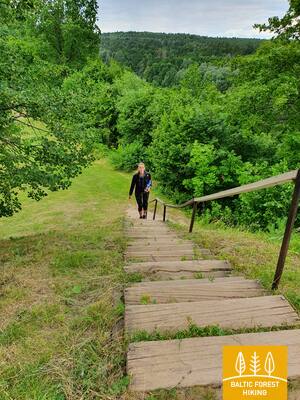
Von Nemunaitis über die Vytauto-Straße und die Landstraße Kaniūkai – Einorai – Nemunaitis (Nr. 1102) führt der Wald-Wanderweg 1,5 km in nordöstliche Richtung, biegt dann links nach Norden ab und erreicht nach 3 km das Dorf Gečialaukis. Dann biegt der Wald-Wanderweg rechts nach Osten ab und nach 3,3 km kommt er wieder auf die Landstraße Nr. 1102 zurück. Nach weiteren 3,3 km erreicht der Wald-Wanderweg die Landstraße Nr. 128 und geht über den Bürgersteig in das Nemunas-Tal hinunter. Von hier führt ein über 3 km langer, schöner Nemunas-Talpfad durch den Wald zu einer Fußgängerbrücke über den Fluss. Nach einem Aufstieg zur höchsten Fußgängerbrücke Litauens öffnet sich der Blick auf die weite und mächtige Landschaft der Nemunas. Hinter der Brücke verläuft der Wald-Wanderweg entlang des ehemaligen Eisenbahndamms, schlängelt sich entlang der kleinen Wege (S. Dariaus und S. Girėno Straße) des Kurparks Alytus und erreicht den Altstadtplatz (Senamiesčio) im Stadtzentrum, an dessen Südseite sich das Tourismusinformationszentrum Alytus befindet.
 58. Etappe. Alytus – Panemunis.
Entlang der Hügel des Dzūkija-Hochlandes
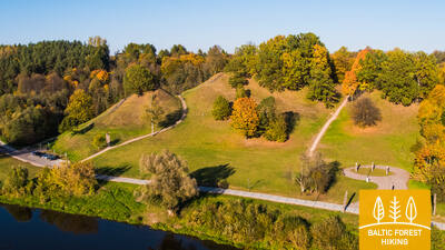
Von Alytus führt der Wald-Wanderweg die Vilniaus-Straße entlang, überquert die Nemunas über die A. Juozapavičiaus-Brücke, biegt dann links in die Jiezno-Straße nach Norden ab und überquert weiter entlang der Miškininkų-Straße die Landstraße Normandijos – Nemunas (Nr. 1334). Nach fast 2 km kommt der Wald-Wanderweg über einen Weg durch den Wald auf eine kleine Landstraße und entlang dieser geht es 8 km in nördlicher Richtung weiter. In dieser Umgebung gibt es ausgedehnte und offene Landschaften der Dzūkija-Hochebene. Hinter dem Dorf Staniava führt der Wald-Wanderweg eine schöne Forststraße hinunter zum Nemunas und dann einen steilen Hang hinauf zum Burghügel Punia, von dem sich ein schöner Blick auf den Fluss eröffnet. Vorbei an der Punia-Kirche, über die Straßen Kauno, Šilo und Birštono erreicht der Wald-Wanderweg nach weniger als 4 km ein größeres Waldmassiv. Nach diesem Wald führt der Wald-Wanderweg zum Dorf Nemajūnai. 3,5 km entfernt ist der Endpunkt dieses Abschnitts.
59. Etappe. Panemunis – Birštonas.
Bögen von Nemunas und ethnografische Gehöfte
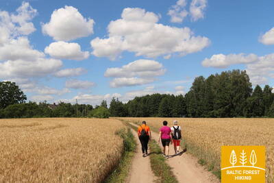
Den Kurven der Memelschleifen folgend, wirft der Wald-Wanderweg mehr als 20 km lange Schleifen im Regionalpark der Memelschleifen und schlängelt sich durch offene Landschaften und kleine Dörfer mit typischen Holzhäusern in verschiedenen Farbtönen. Ein größeres Waldmassiv befindet sich nur zwischen den Dörfern Siponys und Puzonys, durch das der Wanderweg auf kleinen Waldwegen führt. Nach der Überquerung der Schnellstraße Vilnius-Marijampolė (A16), steigt der Wald-Wanderweg zum nächsten Flussschleife der Nemunas ab, wo sich der beliebte Kurort Birštonas befindet. Über den Bürgersteig der B. Sruogos Straße erreicht der Wald-Wanderweg das Tourismusinformationszentrum Birštonas.

60. Etappe. Birštonas – Alksniakiemis.
Durch den Kurort Birštonas
Nach dem Tourismusinformationszentrum Birštonas führt der Wald-Wanderweg für mehr als 1 km entlang der Uferpromenade der Nemunas, biegt dann in die Algirdo-Straße ein, durchquert den Vytautas Jurgis Meška-Park, kehrt zur Promenade zurück und biegt nach 0,6 km auf den Fuß- und Radweg ab. Der Weg durchquert den Wald Žvėrinčiaus für ca. 5 km, dann führt der Wanderweg durch das Erholungsgebiet Paprienė und erreicht die Brücke Greimų über den Fluss Nemunas. Nach der Brücke verläuft der Wald-Wanderweg entlang der Vytauto, Nemuno, J. Zdebskio, Kęstučio, J. Basanavičiaus Straßen und verlässt den zentralen Teil von Prienai entlang der Straße Kęstučio (Nr. 3306). Entlang der Paupio-Straße bildet sie eine Loipe um die Flussschleife des Nemunas und biegt etwa 7 km vom Zentrum von Prienai nach links in nordöstlicher Richtung nach Alksniakiemis ab. Ein Teil dieses Abschnitts ist Teil des Regionalpark Memelschleifen.
61. Etappe. Alksniakiemis – Pakuonis.
Entlang den Ufern des Nemunas durch den Kalvių-Wald
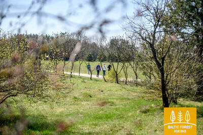
Von Alksniakiemis aus windet sich der Wald-Wanderweg auf einer kleinen Landstraße am linken Ufer der Nemunas entlang und wirft einen mehr als 7 km langen Bogen an Waldwegen und Pfaden vorbei durch das Waldmassiv Kalvių. Vom Dorf Vanga bis Pašventupys, etwa 3 km lang, verläuft der Wald-Wanderweg nahe dem Ufer der Nemunas, von wo aus sich weite Landschaften öffnen. Wanderer werden hier von kleinen Dörfern mit blühenden Gärten im Frühjahr und Sommer und Booten oder kleinen Schiffen am flachen Ufer des Flusses begeistert sein. Vom Dorf Pašventupys geht es auf der Straße Nr. 3313 weiter, nach ca. 3 km erreicht der Wald-Wanderweg das Stadtzentrum von Pakuonis.