


Baltischer Wald-Wanderweg - North Gauja

Das Nord-Gauja Waldgebiet
VIDZEMES UNBERÜHRTE WÄLDER
Valmiera – Trapene, 123 km, 9.–13. Tag
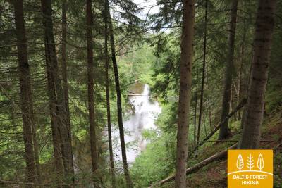
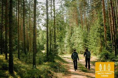
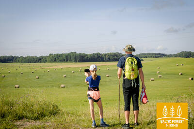
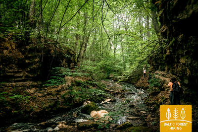
Dieser Routenabschnitt gehört zu den am dünnsten besiedeltsten und waldreichsten entlang des Baltischen Wald-Wanderwegs. Die Wälder sind reich an Pilzen und Beeren, es gibt viele Vögel und Waldtiere. Die Gauja, der längste Fluss Lettlands, mäandert hier durch Dünen, die von lichtem Kiefernwald bedeckt sind. Der Boden ist mit weißer Rentierflechte bedeckt und wegen der hellen Farben wirkt der Wald hier immer wie sonnendurchflutet. Von den höchsten Punkten eröffnen sich beeindruckende Aussichten auf die Flussschleifen der Gauja. Von manchen Stellen blickt man auf weite Wiesen, in deren Mitte alte, majestätische Eichen wachsen. Die für Lettland charakteristische Landschaft mit Einzelhöfen, die von Feldern und Wäldern umgeben sind, liegt hier vor Ihnen.
Die eindrucksvollsten sehenswürdigkeiten: Park der Sinne (Sajūtu parks) an den Steilufern der Gauja – ein Pfad in den Bäumen und ein Barfußgänger-Pfad im Zentrum von Valmiera, Brücke über Gauja bei Strenci, Strenci – alte Flößer-Stadt, Seda – in den 50er Jahren im Stil des Sozialistischen Klassizismus erbautes Städtchen, Cirgalu-Dünen mit Aussichtsturm, Schloss Zvartava – Schloss im Stil der Neugotik, erbaut im Jahr 1881, Lärchenallee in Trapene, Kalamecu-Markuzu-Schluchten – imponierende Talengen mit Wasserfällen und einer höhlenartigen Nische.
 9. Etappe. Valmiera - Strenči.
An den Ufern des Abuls-Flusses entlang in die alte Flößerstadt Strenči
Der Baltische Wald-Wanderweg durchquert das historische Stadtzentrum von Valmiera und einen Erholungspark mit mehreren Wander- und Nordic Walking Routen, führt über eine Schrägseilbrücke und passiert im weiteren Verlauf die Pauku-Kiefern und den Baiļu-Hügel. Auf dem Abuls-Pfad, der sich entlang der steilen und wilden Ufer des Flusses schlängelt, geht der Wald-Wanderweg bis zur Bierbrauerei Brenguļi weiter. Hinter der Siedlung Pūpoli wandert man durch dünn besiedelte Gebiete und großflächige Waldmassive. Die erste Hälfte dieser Strecke zeichnet sich durch die vielen Sommerhaussiedlungen – Enerģētiķis, Saulītes, Sprīdītis, Gaujmaļi, Pūpoli und Gaujaslāči – aus, die während der Sowjetzeit für die Arbeiter der Industriebetriebe von Valmiera und Umgebung eingerichtet wurden. Im weiteren Verlauf führt der Weg bei Ūdriņas durch ein Altarm-Labyrinth, biegt dann nördlich ab und überquert die Gauja über eine Brücke, an der eine Anlegestelle für Kanufahrer und ein Freizeitplatz eingerichtet sind. Von hier aus sind es noch etwa anderthalb Kilometer bis zum Ortskern von Strenči. Ein Teil dieser Strecke verläuft durch das Landschaftsschutzgebiet „Nord-Gauja“.
10. Etappe. Strenči – Spicu-Brücke.
Durch die pilz- und beerenreichen Wälder von Vidzeme
Diese Etappe des Baltischen Wald-Wanderweges startet am Beginn des Gauja-Naturpfads, der längs des Flusses führt. An zwei Stellen (vor dem Abbiegen nach Seda und bei Kauči) überquert der Wanderweg die Schnellstraße A3 (Vorsicht!), setzt sich dann auf kleinen Waldwegen entlang eines Sand- und Kiestagebaus fort und bringt die Wanderer vor dem Abbiegen nach Oliņas auf eine Straße mit Sandbelag Nach 3,5 km auf dieser Straße biegt man rechts ab und setzt die Wanderung bis zur Spicu-Brücke über kleine und einsame Waldwege fort. Hinter der sogenannten Niedrigen Insel (Zemā sala) bietet sich eine der schönsten Aussichten im ganzen Landschaftsschutzgebiet „Nord-Gauja“. Am Ende der Etappe, wo die Autostraße P24 die Spicu-Brücke überquert, befindet sich ein Rastplatz und eine Wassertouristenunterkunft.
11. Etappe. Spicu-Brücke – Zaķi.
Through the magnificent Cirgaļi dunes
Der Baltische Wald-Wanderweg überquert die Spicu-Brücke und schlängelt sich bis zu den vier Kokšu-Seen (ca. 4 km) weiter, die als eine Kette durch einen kleinen Bach miteinander verbunden sind. In der Nähe der Seen gibt es mehrere Erholungs- und Zeltplätze sowie Naturlehrpfade. Es bieten sich Ausblicke auf wunderbare Landschaften und auf an Pilzen reiche Wälder. Nach dem letzten der Kokšu-Seen, dem Dibena, wandert man weitere eineinhalb bis zwei Stunden und erreicht das Cirgaļu-Dünenmassiv, welches in Nord-Süd-Richtung überquert wird. Auch im weiteren Verlauf passiert der Wanderweg großflächige Wälder, in die kleine Weiler und Seen eingesprenkelt sind. Die Etappe endet in der kleinen Ortschaft Zaķi. Hier gibt es jedoch weder Läden noch Dienstleistungen, weshalb die Transport- und Übernachtungsmöglichkeiten im Voraus geplant werden müssen. Die Strecke führt durch das Landschaftsschutzgebiet „Nord-Gauja“.
 12. Etappe. Zaķi - Gaujiena.
Von Zaķi über das Schloss Zvārtava nach Gaujiena
1,5 km hinter Zaķi verlässt der Baltische Wald-Wanderweg die Autostraße Sēļi–Vireši (P23) und schlängelt sich einen kleinen Landweg entlang, bis er Zvārtava erreicht, wo am Ende einer langen Allee das Schloss steht. Hinter Zvārtava kehrt der Wanderweg auf die Straße P23 zurück und führt nach weiteren 2 km den steilen Hang des Gauja-Flusstals hinauf. Hier liegt die Siedlung Gaujiena. Ein Teil der Strecke liegt im Landschaftsschutzgebiet „Nord-Gauja“.
13. Etappe. Gaujiena - Trapene.
Durch die längste Lärchenallee Lettlands nach Trapene
Von Gaujiena bis Līzespasts führt der Baltische Wald-Wanderweg durch entlegene Wälder, umgeben von großen Sumpfmassiven. Mit Ausnahme von Mežciems gibt es hier keine Ortschaften oder Einzelhöfe. Von Līzespasts bis Trapene verläuft der Wanderweg etwa 5 km an andwirtschaftlichen Flächen entlang; hier sind vereinzelte Gehöfte zu sehen. Nun wandern Sie über den westlichen Teil des Alūksnes-Höhenzugs. Etwa die Hälfte dieser 5 km-Strecke führt durch die eindrucksvolle Lärchenallee von Trapene.