


Miško takas - For visually impaired


 Atkarpa 1. Rygos senamiestis - Baltezers.
Per Rygą – UNESCO pasaulio paveldo vietą
Miško tako pradžia Latvijoje yra pačioje Rygos senamiesčio širdyje, Rotušės aikštėje. Maršrutas veda Kaļķu gatve, eina pro Laisvės paminklą, per Vērmanės sodą ir palei istorinę Tērbatas gatvę. Tada jis vingiuoja per Zemitani geležinkelio stoties pėsčiųjų tiltą ir žengia į Biķerniekų ir Šmerlio miškus. Miško takas vingiuoja per Juglą, praeina Latvijos etnografinį muziejų po atviru dangumi ir eina pėsčiųjų-dviračių taku iki Baltezero.
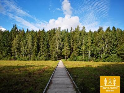
The "Feel Jugla" Walking Trail
Juglos Juglos ežero šiaurės rytinėje dalyje įrengtas 250 metrų medinis lentų takas (į vieną pusę) su apžvalgos aikštele su vaizdu į Juglos ežerą, suoliukas, 20 lytėjimo erdvinių reljefų, vaizduojančių ežerui ir jo apylinkėms būdingas gyvūnų rūšis, informacija Brailio raštu. Jį gali pasiekti žmonės su vežimėliais. Aikštelė yra 0,5 kilometro nuo Mežtakos tako.


Taktilais Brīvības piemineklis
Atidengta per Latvijos gimtadienį – 2022 m. lapkričio 18 d. – Brīvības aikštėje priešais Kārlio Zāles sukurtą originalą ir atidengta 1935 m. lapkričio 18 d. Šią specialią bronzinę miniatiūrą sukūrė skulptorius Ivaras Miķelsons masteliu 1:50.


Atkarpa 83. Paplatelė–Plateliai.
Tarp didžiausių Žemaitijos nacionalinio parko ežerų
Pirmuosius 3,5 km Miško takas veda per gražius spygliuočių miškus. Iki Šaltojo karo muziejaus jis eina Plokštinės pažintiniu taku, o 5 km nuo muziejaus – Plokštinės pėsčiųjų ir dviračių taku. Prie kelio Nr. 3202 (Malūno gatvė) maršrutas pasuka kairėn į pietryčius ir iškart už 0,3 km dešinėn į pietus-pietvakarius. Po maždaug 0,5 km pasiekia Ilgio ežero gatvę. Toliau net 5,5 km maršrutas suka platų ratą aplink Ilgio ir Beržoro ežerus, kol pasiekia Beržoro kaimą. Toliau paėjėjus 2 km Plungės gatve, Miško takas atveda į Platelių centrą ir apsuka dar vieną ratą Ežero gatve iki Šeirės pažintinio tako, atskleisdamas vaizdingą kraštovaizdį. Toliau Ežero, Naująja ir Žemaičių Kalvarijos gatvėmis grįžta į miesto centrą.
Šeire's Educational Trail
Tako ilgis yra apie 7 kilometrai, tačiau yra įrengta apžvalgos aikštelė, skirta žmonėms su vežimėliais, nuo kurios atsiveria vaizdas į Platelių ežerą ir jo salas. Plateliai yra Žemaitijos nacionaliniame parke. Informacinėje lentoje yra apčiuopiamas ežero su salomis žemėlapis, leidžiantis jį tyrinėti žmonėms su regėjimo negalia. Automobilių stovėjimo aikštelė yra čia: GPS 56.048355, 21.826901. Jis yra šalia Mežtakos tako.


Plokštines militārā pilsēta
Nuo 1993 metų buvusį sovietų armijos objektą valdo Žemaitijos nacionalinio parko direkcija. Daugelis karinio miestelio pastatų 2017 metais buvo nugriauti dėl apgriuvusios būklės. Šiuo metu teritorijoje yra likę maždaug 10 pastatų, kuriuos lankytojai gali apžiūrėti iš išorės. Yra informacinės lentelės, kuriose pasakojama apie buvusius pastatus ir jų paskirtį. Įrengtas lytėjimo stendas - žemėlapis, supažindinantis su pastatais, jų vieta ir funkcijomis.


Atkarpa 84. Plateliai–Salantai.
Link Pajūrio žemumos
Miško takas 6 km eina kelio Plateliai-Salantai (Nr. 2302) pakraščiu. Šioje atkarpoje maršrutas leidžiasi Žemaičių aukštumos vakarine dalimi. Keliaujant link Pajūrio žemumos atsiveria graži kraštovaizdžio panorama. Gintališkės kaimo centre Miško takas veda kairėn į pietvakarius ir 2,4 km vingiuoja keliu Nr. 3216, po to suka dešinėn į vakarus, kur kerta didžiausią miško masyvą šioje atkarpoje. Sovietmečiu čia buvo raketų bazė, tai rodo betoninėmis plokštėmis klotas kelias. Toliau maršrutas eina Plungės–Salantų keliu (Nr. 169) ir už 1,4 km nuveda kairėn. Iki pat Salantų jis vingiuoja nedideliu keliuku, o miestelio centrą pasiekia Žemaitės ir M. Valančiaus gatvėmis. Maršruto pradžia – Žemaitijos nacionaliniame parke, o pabaiga – Salantų regioniniame parke.
Šeire's Educational Trail
Tako ilgis yra apie 7 kilometrai, tačiau yra įrengta apžvalgos aikštelė, skirta žmonėms su vežimėliais, nuo kurios atsiveria vaizdas į Platelių ežerą ir jo salas. Plateliai yra Žemaitijos nacionaliniame parke. Informacinėje lentoje yra apčiuopiamas ežero su salomis žemėlapis, leidžiantis jį tyrinėti žmonėms su regėjimo negalia. Automobilių stovėjimo aikštelė yra čia: GPS 56.048355, 21.826901. Jis yra šalia Mežtakos tako.
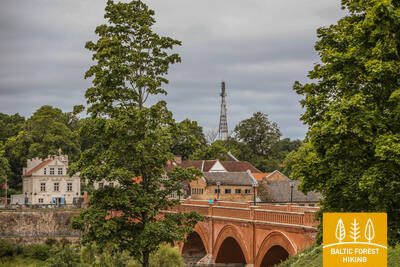
Atkarpa 92. Snėpelė–Kuldyga.
Į Kuldygą – žaviausią viduramžių Kuržemės miestą
Pagrindine Snėpelės gatve Miško takas veda į kelią V1294 ir po 0,3 km priešais Kepšų ežerą pasuka dešinėn į nedidelį kaimo kelią. Šiuo keliu maršrutas pasiekia Slipinciemą, prieš tai kirtus Sprincupės užtvanką ir eina palei tvenkinį. Toliau pasuka Pelčių kryptimi, kur vingiuoja palei Dambų tvenkinius, veda iki Kuldygos–Pelčių kelio (V1293) ir tęsiasi per Kuldygos sodus „Kurzemīte“ ir „Rumba“, kol pasiekia Ventos upę ir Kuldygos aplinkkelį. Nuo jo iki Senojo plytų tilto 2,4 km maršrutas veda gražiu Ventos pakrantės taku, kur drėgnesnė vietose ir per upelius nutiesti mediniai tilteliai.
The walking trail along the Venta River in Kuldīga
Takas driekiasi kairiuoju Ventos upės krantu nuo Kuldygos miesto sodo iki naujojo Kuldygos tilto, įveikdamas 2,4 kilometro. Palei taką įrengtos poilsio zonos ir informacinės lentos. Dėl lygaus paviršiaus, kurį sudaro smulkus, kietas žvyras, jis prieinamas žmonėms su vežimėliais, nors kai kuriose atkarpose dėl nuolydžių gali prireikti pagalbos. Takas platus, o ten, kur kerta nedideles upelių daubas, nutiesti mediniai lentų takai, tilteliai. Ši Mežtakos tako atkarpa driekiasi Kuldygos promenados taku. Galimi pritaikyti tualetai. Įrengta automobilių stovėjimo aikštelė prie GPS: 56.973354, 21.977798.


 Atkarpa 93. Kuldyga–Renda.
Ventos slėniu ir Riežupės gamtos parku
Už senojo plytų tilto per Ventą Miško takas trumpai eina daubų išraižytu dešiniuoju upės krantu, Krasta gatve ir keliu Vetklinika–Paleja, tuomet kerta Kalnmuižos mišką, Riežupę ir toliau iki Mazrendos driekiasi plačiais Rendos miško keliais. Reljefas čia lygus, nes atkarpa yra Kuršo žemumos Pieventos lygumoje. Mazrendoje maršrutas pereina smėlio ir žvyro karjerą ir Kuldigas gatve veda į Rendos centrą. Visas maršrutas eina Ventos slėnio gamtos rezervato ir Riežupės gamtos parko teritorija.
Audio guide "Through Mežtaka in Kuldīga for People with Visual Impairments"
2024 metais sukurtas audiogidas „Per Kuldygos Mežtaką regos negalią turintiems žmonėms“. Jis prasideda nuo Kuldygos apžvalgos bokšto, kerta seną mūrinį tiltą per Ventos upę ir padeda naršyti Kuldygos promenados taką palei Ventą. Informacija apžvalgos bokšte ir netoliese pateikiama Brailio raštu. Įrengta automobilių stovėjimo aikštelė prie GPS: 56.973354, 21.977798.


Atkarpa 100. Bigauņciemas– Dubultai.
Istoriniu Jūrmalos kurortu
Nuo Bigauņciemo aiškiai matosi visas Jūrmalos krantas. Šios dienos atkarpos pirma dalis driekiasi Kemerių nacionaliniu parku. Nuo Jaunkemerių iki pat Dubultų einama plačiausiu Rygos įlankos smėlio paplūdimiu, per istorinį Jūrmalos kurortą ir ilgiausią Latvijos miestą. Verta prisiminti, kad gražiomis ir šiltomis vasaros dienomis būna daug paplūdimio lankytojų.
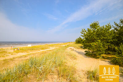
The Dubulti Coastal Dunes Trail
2024/2025 metais Jūrtakos tako atkarpa bus sukurta ir pritaikyta kaip specialus maršrutas žmonėms su regėjimo negalia.


Atkarpa 101. Dubulti - Lielupe - Bulduri.
Populiariausi paplūdimiai Latvijoje
Plačiausias Rygos įlankos smėlio paplūdimys driekiasi nuo Dubultų iki Lielupės upės. Tai didžiausia Jūrmalos kurorto vertybė, siūlanti daugybę paplūdimio kavinių ir įvairių poilsio galimybių. Pakrantės kopų miškus juosia tankus takų tinklas, skirtas tiek pasivaikščiojimams, tiek šiaurietiškam ėjimui. Jūrų tako dalis nuo Lielupės paplūdimio iki Jūrmalos buities muziejaus priskiriama Ragakapos gamtos parkui. Iš čia atgal į Buldurus galima patogiai patekti einant Buldurų prospektu ir 5. līnija.
The Dubulti Coastal Dunes Trail
2024/2025 metais Jūrtakos tako atkarpa bus sukurta ir pritaikyta kaip specialus maršrutas žmonėms su regėjimo negalia.