


Mežtaka - Pielāgots redzes ierobežojumiem


 1. posms. Vecrīga - Baltezers.
Cauri Rīgai – UNESCO Pasaules mantojuma vietai
Latvijā Mežtakas sākums atrodams Vecrīgas sirdī – Rātslaukumā. Maršruts ved pa Kaļķu ielu, garām Brīvības piemineklim, cauri Vērmanes dārzam un pa vēsturisko Tērbatas ielu. Tālāk tas izmet loku pa gājēju tiltu pāri Zemitānu dzelzceļa stacijai un turpinās pa Biķernieku un Šmerļa mežiem. Mežtaka vijas cauri Juglai, gar Latvijas Etnogrāfisko brīvdabas muzeju un pa gājēju un velosipēdistu celiņiem aizved līdz Baltezeram.
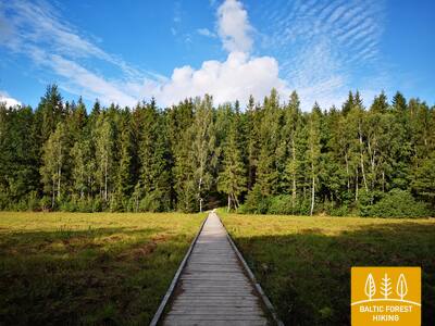
Pastaigu taka "Sajūti Juglu"
Juglas ezera ziemeļaustrumu daļā - Juglā 250 m garumā (vienā virzienā) ir izveidotas koka laipas ar skatu platformu uz Juglas ezeru, soli, 20 taktīlie telpiskie ciļņi ar ezera un apkaimes raksturīgajām dzīvnieku sugām, informācija Braila rakstā. Pieejama cilvēkiem ar ratiņkrēslu. Atrodas 0,5 km attālumā no Mežtakas.


Taktilais Brīvības piemineklis
Atklāts Latvijas dzimšanas dienā – 2022. gada 18. novembrī Brīvības laukumā iepretim Kārļa Zāles veidotajam un 1935. gada 18. novembrī atklātajam oriģinālam. Šo īpašo bronzas miniatūru izveidoja tēlnieks Ivars Miķelsons mērogā 1:50.


83. posms. Paplatelė – Plateliai.
Apkārt lielākajiem ezeriem Žemaitijas Nacionālajā parkā
Pirmos 3,5 km Mežtaka ved pa skaistiem mežiem, kas klāj Žemaitijas augstienes paguru nogāzes. Līdz Aukstā kara muzejam tā sakrīt ar Plokštines izziņas taku. No muzeja Mežtaka 5 km garumā seko Plokštinės ceļam, kur izveidots gājēju/veloceliņš un, tuvojoties Plateļu ezeram, nolaižas ezera ieplakā. Pie ceļa Nr. 3202 (Malūno iela) Mežtaka pagriežas pa kreisi uz dienvidaustrumiem un tūlīt pēc 0,3 km seko pagrieziens pa labi uz dienvidiem - dienvidrietumiem. Pēc aptuveni 0,5 km tā sasniedz Ilgio Ežero ielu. Nākamo 5,5 km garumā Mežtaka apmet plašu loku apkārt Iļģa un Beržoras ezeriem, sasniedzot Beržoras ciemu. Aiz ciema, virzoties pa Plungės ielu pēc 2 km Mežtaka sasniedz Plateļu pilsētas centru un pa Ežero ielu izmet vēl vienu loku līdz pludmalei un Šeireės izziņas takai. Tālāk pa Ežero, Naujoji un Žemaičių Kalvarijos ielām Mežtaka atgriežas pilsētas centrā.
Šeires izziņas taka
Takas garums ir ap 7 km, taču cilvēkiem ar ratiņkrēslu ir pieejama takas skatu platforma ar skatu uz Plateļu ezeru un tā salām. Plateļi atrodas Žemaitijas Nacionālajā parkā. Uz informācijas stenda ir taktīla ezera kontūra ar salām, kas ļauj to iepazīt cilvēkiem ar redzes ierobežojumiem. Autostāvlaukums ir izvietots šeit: GPS 56.048355, 21.826901. Atrodas blakus Mežtakai.


Plokštines militārā pilsēta
Kopš 1993. gada bijušo Padomju armijas objektu pārvalda Žemaitijas nacionālā parka direkcija. Daudzas militārās pilsētiņas ēkas 2017. gadā tika nojauktas to ārkārtas stāvokļa dēļ. Šobrīd teritorijā ir palikušas aptuveni 10 ēkas, kuras apmeklētājiem var apskatīt no ārpuses. Ir izvietoti informatīvie stendi, kas stāsta par bijušajām ēkām un to mērķi. Ir uzstādīts taktīlais stends - karte, kas iepazīstina ar ēkām, to izvietojumu un funkcijām.


84. posms. Plateliai – Salantai.
Ceļā uz Piejūras zemieni
Mežtaka 6 km iet pa Plateliai–Salantai (Nr. 2302) ceļa nomali. Šajā posmā skatam paveras Žemaitijas augstienes rietumdaļas ainavas pāri Piejūras zemienei. Gintališkes ciema centrā Mežtaka pagriežas pa kreisi uz dienvidrietumiem, nonākot uz ceļa Nr. 3216. Pēc 2,4 km tā pagriežas pa labi uz rietumiem, kur šķērso šajā posmā lielāko meža masīvu. Padomju laikā šeit atradās raķešu bāze, par ko liecina ar betona plāksnēm noklātais ceļš. Tālāk Mežtaka īsu brīdi seko Plungė–Salantai ceļam (Nr. 169) un pēc 1,4 km pagriežas pa kreisi. Līdz pat Salantai tā izlokās pa mazu lauku ceļu, bet mazpilsētas centru sasniedz pa Žemaitės un M. Valančiaus ielām. Šī posma sākums atrodas Žemaitijas Nacionālajā parkā, bet finišs – Salantai reģionālajā parkā.
Šeires izziņas taka
Takas garums ir ap 7 km, taču cilvēkiem ar ratiņkrēslu ir pieejama takas skatu platforma ar skatu uz Plateļu ezeru un tā salām. Plateļi atrodas Žemaitijas Nacionālajā parkā. Uz informācijas stenda ir taktīla ezera kontūra ar salām, kas ļauj to iepazīt cilvēkiem ar redzes ierobežojumiem. Autostāvlaukums ir izvietots šeit: GPS 56.048355, 21.826901. Atrodas blakus Mežtakai.
92. posms. Snēpele – Kuldīga.
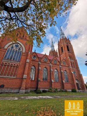
Uz Kuldīgu – šarmantāko Kurzemes viduslaiku pilsētu
Pa Snēpeles galveno ielu Mežtaka izved uz ceļa V1294 un jau pēc 0,3 km iepretī Ķepšu ezeram nogriežas pa labi uz neliela lauku ceļa. Pa šo ceļu Mežtaka aizlīkumo līdz Slipiņciemam, pirms tā pa dambi šķērsojot Sprincupi, uz kuras izveidots dīķis. Tālāk Mežtaka dodas Pelču virzienā. Pelču apkaimē taka izlokās gar Dambu dīķiem, izved uz Kuldīgas–Pelču ceļa (V1293) un tālāk stiepjas cauri Kuldīgas dārziņu rajoniem – Kurzemītei un Rumbai, līdz sasniedz Ventas krastu un Kuldīgas apvedceļu. No tā līdz pat Senajam ķieģeļu tiltam Mežtaka 2,4 km garumā ved pa skaistu Ventas krasta taku, kur mitrākās vietās un pāri strautiem ir koka tiltiņi un laipas.
Pastaigu taka gar Ventu Kuldīgā
Taka vijas gar Ventas kreiso krastu no Kuldīgas pilsētas dārza līdz Kuldīgas jaunajam tiltam 2,4 km garumā. Tās malā ir izvietotas atpūtas vietas un informācijas stendi. Taka ir ērta cilvēkiem ar ratiņkrēslu, jo tās virsma ir līdzena – tā sastāv no smalkas, cietas grants, tomēr dažās vietās tā izejama tikai ar asistenta palīdzību tās slīpuma dēļ. Taka ir plata un vietās, kur to šķērso mazu strautu gravas, tiem pāri ir izveidotas koka laipas un tiltiņi. Mežtaka šajā posmā ved pa Kuldīgas pastaigu taku. Ir pielāgotas WC. Ir izveidots autostāvlaukums: 56.973354, 21.977798.
2024. g. ir izveidots audiogids "Pa Mežtaku cauri Kuldīgai cilvēkiem ar redzes traucējumiem, kas sākas pie Kuldīgas skatu torņa, šķērso veco ķieģeļu tiltu pāri Ventai un palīdz iespazīt Kuldīgas pastaigu taku gar Ventu. Skatu tornī un pie tā informācija ir izvietota Braila rakstā. Ir izveidots autostāvlaukums: 56.973354, 21.977798.


 93. posms. Kuldīga – Renda.
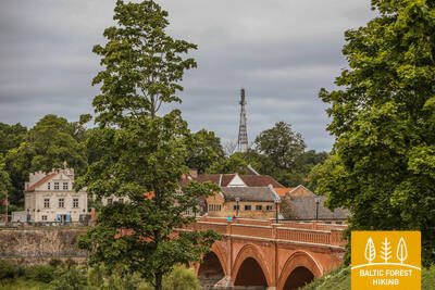
Rendas meži – nacionālo partizānu cīņu vietas
Aiz Senā ķieģeļu tilta pāri Ventai Mežtaka īsu brīdi turpinās pa gravām izroboto Ventas labo krastu, virzās pa Krasta ielu un Vetklīnikas–Palejas ceļu, šķērso Kalnmuižas mežu, Riežupi un tālāk līdz pat Mazrendai turpinās pa plašā Rendas mežu masīva ceļiem. Reljefs šeit ir līdzens, jo posms ietilpst Kursas zemienes Pieventas līdzenumā. Mazrendā Mežtaka šķērso smilšu-grants karjeru un pa Kuldīgas ielu aizved līdz Rendas centram. Posms ietilpst dabas lieguma “Ventas ieleja” un dabas parka “Riežupe” teritorijā.
Audiogids "Pa Mežtaku cauri Kuldīgai cilvēkiem ar redzes traucējumiem"
2024. g. ir izveidots audiogids "Pa Mežtaku cauri Kuldīgai cilvēkiem ar redzes traucējumiem, kas sākas pie Kuldīgas skatu torņa, šķērso veco ķieģeļu tiltu pāri Ventai un palīdz iespazīt Kuldīgas pastaigu taku gar Ventu. Skatu tornī un pie tā informācija ir izvietota Braila rakstā. Ir izveidots autostāvlaukums: 56.973354, 21.977798.


100. posms. Bigauņciems - Dubulti.
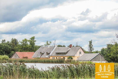
Latvijas populārākā kūrortpilsēta un galvaspilsēta
No Bigauņciema labi redzams Jūrmalas krasts visā tā garumā. Šīs dienas posma daļa ietilpst Ķemeru Nacionālajā parkā. No Jaunķemeriem līdz pat Dubultiem gājiens norit pa Rīgas jūras līča platāko smilšu pludmali, cauri Jūrmalas vēsturiskajam kūrortam un Latvijas garākajai pilsētai. Skaistās un siltās vasaras dienās jārēķinās ar daudzajiem pludmales apmeklētājiem.
Labsajūtas dabas taka
Jūrmalas piekrastē, kāpu joslā no Baznīcas ielas Dubultos līdz Amatas ielai Pumpuros, aptuveni divu kilometru garumā izveidota dabas taka, kas paredzēta mierīgai atpūtai, iepazīšanai ar apkārtējo vidi un dažādām kustību aktivitātēm.
Taka ir ērti izmantojama gan pastaigu cienītājiem, gan nūjotājiem un skrējējiem. Maršrutā var izjust piejūras kāpu raksturīgo ainavu un mainīgo reljefu.
Ceļā izvietoti norobežojoši elementi, trīs atpūtas soliņi, koka seguma laukums ar piknika galdu un sēdvietām, skatu platforma un terase ar izstieptu tīklu. Ir arī īpašs sensorais posms, kurā var sajust dažādus dabas materiālus — smiltis, oļus un čiekurus. Takas vidē izvietoti divi trenažieri, kas dod iespēju izkustēties un izvingroties. Maršruts aprīkots ar norādēm, kā arī informatīviem stendiem par vietējo dabu, veselīgu dzīvesveidu un fizisko aktivitāšu nozīmi cilvēka pašsajūtai.
Labsajūtas dabas takā esošie informatīvie stendi ir papildināti ar taktilām kartēm cilvēkiem ar redzes traucējumiem. Izmantojot tausti, tie ļaus iegūt priekšstatu par taku, tās izvietojumu attiecībā pret apkārtnes ielām un uz kartes ir izvietota informācija braila rakstā.
Karšu dizainu veidoja un kartes izgatavoja kompānija "Socintegra", kas specializējas plaša spektra vides pielāgošanas pakalpojumu sniegšanā.
Par taku ir pieejams audio gids aplikācijā Izi.Travel. (Labsajūtas dabas taka / Wellness nature trail) latviešu un angļu valodās un ar tā palīdzību ir iespējams audio formātā noklausīties informāciju, kas izvietota uz takas informatīvajiem stendiem.


101. posms. Dubulti - Lielupe - Bulduri.
Populārākās Latvijas pludmales
Maršruts piemērots ikviena vecuma un fiziskās sagatavotības gājējam. Starp Dubultiem un Lielupi plešas Rīgas jūras līča platākais smilšu liedags – Jūrmalas kūrorta nozīmīgākā vērtība ar daudzām pludmales kafejnīcām, dažādām atpūtas iespējām. Piekrastes kāpu mežus caurvij blīvs taku tīkls, kas piemērots iešanai un nūjošanai. Jūrtakas daļa starp Lielupes pludmali un Jūrmalas brīvdabas muzeju ietilpst Ragakāpas dabas parkā. No šejienes atpakaļ uz Bulduriem var ērti nokļūt pa Bulduru prospektu un 5. līniju.
Labsajūtas dabas taka
Jūrmalas piekrastē, kāpu joslā no Baznīcas ielas Dubultos līdz Amatas ielai Pumpuros, aptuveni divu kilometru garumā izveidota dabas taka, kas paredzēta mierīgai atpūtai, iepazīšanai ar apkārtējo vidi un dažādām kustību aktivitātēm.
Taka ir ērti izmantojama gan pastaigu cienītājiem, gan nūjotājiem un skrējējiem. Maršrutā var izjust piejūras kāpu raksturīgo ainavu un mainīgo reljefu.
Ceļā izvietoti norobežojoši elementi, trīs atpūtas soliņi, koka seguma laukums ar piknika galdu un sēdvietām, skatu platforma un terase ar izstieptu tīklu. Ir arī īpašs sensorais posms, kurā var sajust dažādus dabas materiālus — smiltis, oļus un čiekurus. Takas vidē izvietoti divi trenažieri, kas dod iespēju izkustēties un izvingroties. Maršruts aprīkots ar norādēm, kā arī informatīviem stendiem par vietējo dabu, veselīgu dzīvesveidu un fizisko aktivitāšu nozīmi cilvēka pašsajūtai.
Labsajūtas dabas takā esošie informatīvie stendi ir papildināti ar taktilām kartēm cilvēkiem ar redzes traucējumiem. Izmantojot tausti, tie ļaus iegūt priekšstatu par taku, tās izvietojumu attiecībā pret apkārtnes ielām un uz kartes ir izvietota informācija braila rakstā.
Karšu dizainu veidoja un kartes izgatavoja kompānija "Socintegra", kas specializējas plaša spektra vides pielāgošanas pakalpojumu sniegšanā.
Par taku ir pieejams audio gids aplikācijā Izi.Travel. (Labsajūtas dabas taka / Wellness nature trail) latviešu un angļu valodās un ar tā palīdzību ir iespējams audio formātā noklausīties informāciju, kas izvietota uz takas informatīvajiem stendiem.