


Mežtaka - Veclaicene

Veclaicenes mežaine
SKAISTĀKĀS ZIEMEĻLATVIJAS PAUGURAIŅU AINAVAS
Trapene – Korneti: 44 km, 14.–15. diena
Mežtaka ved cauri Alūksnes augstienei. Šis ir viens no iešanai sarežģītākajiem posmiem, jo apvidus ir paugurains. Te ir daudz ledāja veidotu gravu un pauguru ar plašiem panorāmas skatiem līdz pat Igaunijai un Munameģim. Augstākie pauguri ir tūkstošiem gadu seni pilskalni, kas ar nolūku izvēlēti augstās vietās, lai laicīgi pamanītu ienaidnieka tuvošanos. Mežtaka šajā posmā met nelielu līkumu caur Paganamā (Paganamaa) jeb Velna zemi Igaunijā, kur ir skatu tornis un gleznaini mežezeri. Visskaistākās ainavas ir pavasaros, kad zied pienenes, un rudeņos, kad krāsojas koku lapas.
Spilgtākie iespaidi: Alūksnes augstienes ainavas ar pauguriem un ezeriem, Apes vēsturiskais centrs – dolomīta ēkas un bruģis, Kornetu-Peļļu subglaciālā iegultne – viena no iespaidīgākajām Latvijā, Drusku pilskalns un Dzērves kalna skatu tornis, Raganu klintis Vaidavas upes krastā.
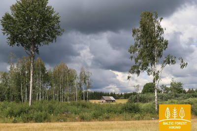
 14. posms. Trapene - Ape.
Uz Api, kur Vaidavas upes krastos raganas mitušas
Pirmie 6 Mežtakas kilometri ved gar ceļa P44 malu, līdz nogriežas uz ziemeļiem – uz Ādama–Apes ceļa. 4 km pirms Rīgas–Pleskavas autoceļa (A2) Mežtaka ved pa lielu un skaistu mežu masīvu, kas rudenī priecē ar bagātīgām ogu un sēņu ražām. Aiz Rīgas–Pleskavas autoceļa Mežtaka izvijas cauri lauksaimniecībā izmantojamām zemēm, līdz sasniedz Apes, vienas no mazākajām Latvijas pilsētām, centru, pirms tam šķērsojot bijušo Apes–Valkas šaursliežu dzelzceļa līnijas vietu.
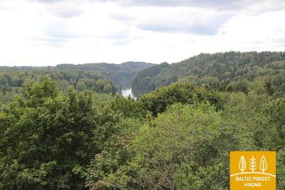
 15. posms. Ape – Paganamā – Korneti – Latvijas/Igaunijas robeža.
Cauri Kornetu-Peļļu vagai un Paganamā jeb Velna zemei
Pametusi Api, Mežtaka pirmos kilometrus vijas pa paugurainām lauksaimniecības zemju ainavām, tad atkal ieskrien lielā mežu masīvā, ko pārtrauc tikai daudzo ezeriņu un ezeru zilie spoguļi. Aiz Peļļiem Mežtaka sakrīt ar Peļļu taku, šķērso Latvijas/Igaunijas robežu un 2 km izvijas gar Smilšāja, Sūnekļa un Ilgāja ezera krastiem Igaunijas pusē, ko sauc par Paganamā (tulkojumā – Velna zeme). Šeit tā nolaižas t. s. Kornetu-Peļļu subglaciālajā iegultnē, kas ir viena no iespaidīgākajām Latvijas gravām. Pie Ilgāja Mežtaka atkal atgriežas Latvijā un pa izteikti paugurainu apvidu aizved līdz Drusku pilskalnam, kas sasniedzams, kāpjot pa stāvu taku. Kornetos Mežtaka atkal „nolaižas” lejā. No Kornetu centra līdz Latvijas/Igaunijas robežai ir nepilni 3 km. Pa ceļam vērojamas skaistas ainavas Lielā un Mazā Baltiņa krastos. Posms atrodas aizsargājamo ainavu apvidū „Veclaicene”.