


Mežtaka - Ziemeļgauja

Ziemeļgaujas mežaine
NESKARTĀKAIS VIDZEMES MEŽU APVIDUS
Valmiera – Trapene: 123 km, 9.–13. diena
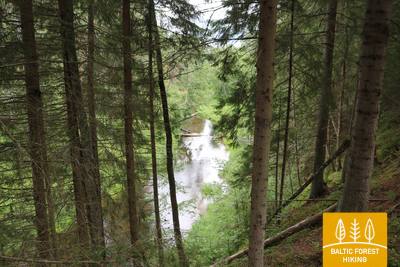
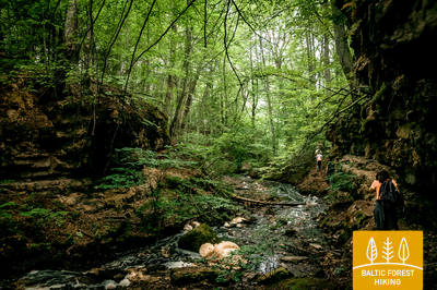
Viens no vismazāk apdzīvotajiem un mežainākajiem apvidiem Mežtakā. Mežos ir bagātīgas sēņu un ogu vietas, daudz putnu un meža dzīvnieku. Gauja, Latvijas garākā upe, šeit met plašus lokus starp iekšzemes kāpu masīviem, ko klāj skraji, caurredzami priežu meži. Zemi sedz balti briežu ķērpji, un gaišo krāsu dēļ mežs te vienmēr izskatās kā saules pieliets. No augstākām vietām redzami izteiksmīgi skati pāri Gaujas līkumiem. Vietām skatam paveras plašas pļavas, kuru vidū aug veci, majestātiski ozoli. Vērojama Latvijai raksturīga ainava ar viensētām lauku un mežu ielokā.
Spilgtākie iespaidi: Gaujas stāvo krastu Sajūtu parks, kur daba ienāk Valmieras centrā, Tilts pār Gauju pie Strenčiem, Strenči – pilsēta ar senām plostnieku aroda tradīcijām, Seda - sociālisma pilsētbūvniecības stilā celta pilsēta un Staļina laika klasicisma arhitektūra, Cirgaļu iekšzemes kāpas un skatu tornis, Zvārtavas pils - neogotikas stila pils, Trapenes lapegļu aleja, Kalamecu-Markūzu gravas - krāšņas gravas ar ūdenskritumiem un alveidīgu nišu.
 9. posms. Valmiera - Strenči.
Gar Abula krastiem uz Strenčiem – plostnieku galvaspilsētu
Mežtaka izvijas cauri Valmieras vēsturiskajam centram un Atpūtas parkam, kurā ir vairāki pilsētas apkaimes kājāmiešanas un nūjošanas maršruti, šķērso Vanšu tiltu, ved gar Pauku priedēm un Baiļu kalnu. Pa Abula taku, kas izlokās pa stāvajiem un „mežonīgajiem” upes krastiem, tā aizlīkumo līdz Brenguļu alus darītavai un tālāk, aiz Pūpoliem, jau ved pa mazapdzīvotiem, plašiem mežu masīviem. Šī posma pirmās puses raksturīga iezīme ir mazie vasarnīcu ciemi – Enerģētiķis, Saulītes, Sprīdītis, Gaujmaļi, Pūpoli un Gaujaslāči, kas sāka veidoties padomju laikā kā Valmieras un apkaimes rūpniecības uzņēmumu vasarnīcu rajoni. Pie Ūdriņām Mežtaka izved cauri vecupju labirintam un pagriežas uz ziemeļiem, šķērsojot Gaujas tiltu, pie kura ir atpūtas un laivotāju pieturvieta. No šejienes līdz Strenču centram ir ~ 1,5 km. Daļa no posma atrodas Ziemeļgaujas aizsargājamo ainavu apvidū.
10. posms. Strenči - Spicu tilts.
Cauri skaistajiem Vidzemes sēņu un ogu mežiem
Mežtakas sākums šajā posmā sakrīt ar Gaujas dabas taku, kas ved gar pašu upes krastu. Mežtaka divās vietās (pirms Sedas pagrieziena un Kaučiem) šķērso A3 ceļu (uzmanīgi!) un turpinās pa maziem meža ceļiem, gar smilšu-grants karjeru, bet pie Oliņu pagrieziena izved uz grantēta ceļa. Pēc 3,5 km gājuma pa to atkal jāpagriežas pa labi, un turpmākais maršruts līdz Spicu tiltam ved pa maziem un nomaļiem meža ceļiem, kur aiz t. s. Zemās salas atrodas viens no skaistākajiem aizsargājamo ainavu apvidus „Ziemeļgauja” skatiem. Posma galapunktā, kur ceļš P24 šķērso Spicu tiltu, ir izveidota atpūtas vieta un ūdenstūristu apmetne.
11. posms. Spicu tilts - Zaķi.
Pa ainavisko Cirgaļu kāpu apgabalu
Mežtaka šķērso Spicu tiltu un aizlokās līdz četriem Kokšu ezeriem (ap 4 km), ko virknē savieno mazs strauts. To apkaimē ir izveidotas atpūtas un telts vietas un dabas izziņas taka. Te ir skaistas ainavas un lieliski sēņu meži. Aiz pēdējā no Kokšu ezeriem – Dibena ezera – pēc pusotras līdz divu stundu gājiena nokļūstam Cirgaļu kāpu masīvā, ko šķērsojam ziemeļu–dienvidu virzienā. Arī tālākais Mežtakas posms šķērso lielu mežu apgabalu, kur redzama kāda savrupa viensēta vai mazs ezeriņš. Posms beidzas mazā ciematā ar nosaukumu Zaķi, kur nav pakalpojumu, tādēļ, plānojot gājienu, ir jāpārdomā loģistika un nakšņošanas iespējas. Posms atrodas aizsargājamo ainavu apvidū „Ziemeļgauja”.
 12. posms. Zaķi - Gaujiena.
Gar Zvārtavas pili uz Gaujienu
Aiz Zaķiem pēc 1,5 km gājiena Mežtaka nogriežas no Sēļu–Virešu ceļa (P 23) un tālāk līkumo pa mazu lauku ceļu līdz pat Zvārtavai, kur garas koku alejas galā redzama Zvārtavas pils. Aiz Zvārtavas Mežtaka atgriežas uz ceļa P 23 un pēc 2 km uzskrien Gaujas ielejas stāvajā krastā, kur atrodas Gaujienas centrs. Daļa no posma atrodas aizsargājamo ainavu apvidū „Ziemeļgauja”.
13. posms. Gaujiena - Trapene.
Pa garāko Latvijas lapegļu aleju uz Trapeni
No Gaujienas līdz Līzespastam Mežtaka ved pa ļoti nomaļiem mežiem, kurus ieskauj lieli purvu masīvi. Izņemot Mežciemu, šeit nav apdzīvotu vietu un pat viensētu. Savukārt, no Līzespasta līdz Trapenei 5 km garumā Mežtaka jau izlokās caur atklātām un lauksaimniecības ainavām ar atsevišķām viensētām, iezīmējot Alūksnes augstienes rietumdaļas paugurainās nogāzes. Apmēram pusi no minētajiem 5 km abpus ceļam slejas iespaidīgā Trapenes lapegļu aleja.