


Jūrtaka - Harjumā un Tallina

Ziemeļrietumigaunijas klintis un ūdenskritumi
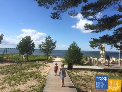
Somu līča krasts
Nõva – Tallinn: 158 km, 53.–60. diena
Visdaudzveidīgākais Jūrtakas posms Igaunijā, kurā jaušama ziemeļu daba. Te ir redzami laukakmeņi, smilšaini liedagi, zāļainas piejūras pļavas un iežu gabali, kas ir sena meteorīta sprādziena rezultāts. Te atrodas Pakri klintis – iespaidīgākā Baltijas valstu piekrastes siena 24 m augstumā. Maršruts iet jūras krasta tuvumā, vietām
pa mežu un lauku ceļiem. Ainavā redzamas muižas, baznīcas, bākas un Pakri vēja parks. Apskatāms skaistais Keila–Joa ūdenskritums un noslēpumainās Pakri salas. Tallinas apkaimē ir saglabājušās daudzas militārā mantojuma vietas – krasta līnijas nocietinājumi un krasta aizsardzības baterijas. Paldiski padomju laikā bija slēgtā pilsēta un sevišķi slepens militārais objekts, kurā atradās īpaši izveidots kodolzemūdeņu reaktors – militāro speciālistu apmācības vieta. Jūrtaka beidzas Tallinas centrā, kuras viduslaiku vecpilsēta ir UNESCO vēsturiskā mantojuma objekts.
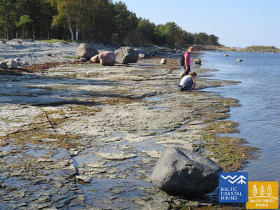
 53. posms. Nõva - Vihterpalu.
Gar Somu jūras līci
No Rannaküla, apmetot loku mitrājam, Jūrtaka šķērso Nõva upīti un izved Keibu līča pludmalē (sākumā – aizaugusi), kur plešas smilšains liedags ar kāpām. Pie Keibu strauta tā nogriežas iekšzemē, kur tālāk sakrīt ar Igaunijas valsts mežu marķēto taku: Peraküla – Aegviidu – Ähijärve. Taka izvijas cauri Keibu ciematiņam un iznāk pie jūras iepretim Alliklepa ciemam, kur ir skaisti kadiķu lauki. Tālāk taka ved starp jūru un diviem maziem ezeriņiem, kas kādreiz bijuši līči. Tiem iepretim jūras gultnē atsedzas dolomīts. Tālāk līdz pat Vintse ciemam taka iet pa mazu jūras krasta ceļu (redzamas Pakri salas), līdz nogriežas uz Vihterpalu pusi.
54. posms. Vihterpalu - Padise.
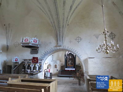
Septiņus gadsimtus veca baznīca un klosteris
Kurkse väin šauruma dienvidu krasts ir klāts ar mitrājiem, tādēļ Jūrtaka aiziet iekšzemē. Jūrtakas lielāka daļa ved cauri mazapdzīvotiem mežu masīviem (sakrīt ar Igaunijas Valsts mežu veidoto taku: Peraküla – Aegviidu – Ähijärve), dažreiz izvedot kādā atklātākā vietā vai ciemā.
55. posms. Padise - Paldiski.
Paldiski – kādreiz slēgtā un slepenā pilsēta
No Padise līdz Karilepa Jūrtaka līkumo pa maziem lauku ceļiem, taču tālāk līdz Madise - gar autoceļa malu. No Madise baznīcas kalna, senā jūras krasta, paveras izcili skati uz Paldiski līci un Pakri salām. Aiz Madise līdz Paldiski maršruts turpinās gar minētā autoceļa malu līdz pilsētas Dienvidu ostai un, virzoties gar tās malu, sasniedz Paldiski dienviddaļā esošo dzelzceļa staciju. Paldiski padomju laikā bija slēgta pilsēta ar militāro ostu un netālu esošo atomzemūdeņu apmācību bāzi Pakri pussalā, kas darbojās uz neliela atomreaktora bāzes. Piemērots aktīviem gājējiem.
56. posms. Paldiski - Kersalu.
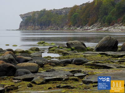
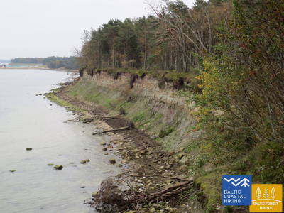
Klintis, bāka un militārais mantojums
Jūrtaka ved apkārt Pakri pussalai, no kuras klinšainajiem krastiem atklājas skaistākās ziemeļrietumu Igaunijas piekrastes ainavas. Tā iziet cauri Paldiski centram un pie Pētera I cietokšņa bastioniem nogriežas uz Pakri bākas pusi, līdz kurienei virzās pa iespaidīgo Pakri klinšu augšdaļu. Tālāk līdz Kersalu ir gan kāpumi – klintis, gan kritumi, kur Jūrtaka vijas gar smilšaini akmeņainu krastmalu un skaistu priežu mežu. Pakri klintis ir interesantas arī aukstās ziemās, kad šeit veidojas iespaidīgi leduskritumi, gan rudens krāsaino lapu laikā. Maršruts piemērots aktīviem un izturīgiem gājējiem.
 57. posms. Kersalu - Laulasmaa.
Pludmales, peldvietas un kūrorts
Maršruts ved gar jūras krastu un mazajiem piekrastes ciemiem. Pie Kersalu Jūrtaka pienāk pie akmeņaina krasta, kur, koku ieslēptas, paceļas vairākus metrus augstas klintis. Tuvojoties Kloogaranna, parādās plašas, smilšainas pludmales ar kāpām. Pie Kloogaranna pludmales Jūrtaka nogriežas uz ciemu, apmet ~ 3 km garu loku pa iekšzemi un tad atkal atgriežas jūras krastā.
58. posms. Laulasmaa - Vääna-Jõesuu.
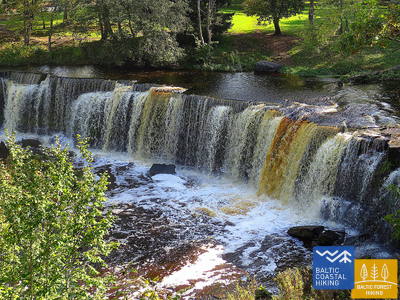
Skaistākais Igaunijas ūdenskritums
Ainaviski daudzveidīgs Jūrtakas posms, kas piemērots izturīgiem gājējiem. Redzamas gan akmeņainas, gan smilšainas pludmales un labas peldvietas, skaisti piekrastes priežu meži, iespaidīgā Türisalu klints siena un dižakmeņi. Pa plašā Keilas Mežaparka takām var aiziet līdz Keilas ūdenskritumam, pie kura uzņemti fragmenti populārajai latviešu mākslas filmai „Vella kalpi”, kā arī iepazīt piekrastes zvejnieku dzīvei veltīto ekspozīciju Lohusalu ciemā.
59. posms. Vääna - Jõesuu - Tabasalu.
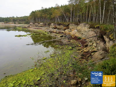
Nostāstiem apvītā Suurupi pussala
Viens no sarežģītākajiem Jūrtakas posmiem, piemērots tikai pieredzējušiem gājējiem. Maršruts apmet loku ap Suurupi pussalu, kuras biezie meži slēpj dažādu vēsturisko periodu militāro mantojumu. Jūrtaka līkumo pa aizaugušām un akmeņainām krastmalām, bērzu birzīm, gar bijušajām pionieru nometnēm un smilšakmens klinšu pasargātiem līcīšiem ar asiem zemesragiem. Dažviet jūrā atsedzas dolomīta pamatne, bet citur redzamas laukakmeņu „salas”. Maršruta noslēgumā jūras krastā paceļas viens no iespaidīgākajiem Igaunijas piekrastes atsegumiem – Rannamõisa klintis, no kurām paveras skats uz Kakumäe līci un pussalu un Tallinas vecpilsētas torņiem.
60. posms. Tabasalu - Tallinas osta.
Tallina – UNESCO pasaules mantojuma vieta
Pie Tabasalu Jūrtaka šķērso Tallinas robežu un cauri Tiskre un Vismeistri rajoniem iznāk Kakumäe pludmalē, kur apmet loku klinšu ieskautajai Kakumäe pussalai pa tās augšdaļu mežā. Te skats pāri Kopli līcim uz Tallinas ostu. Iepretim Õismäe rajonam gar jūras krastu ved lieliska promenāde. Apmetusi loku apkārt Igaunijas Brīvdabas muzejam, Jūrtaka pa krasta promenādi aizlokās līdz Stroomi pludmalei un tālāk aiz Pelguranna rajona pa gājēju ietvēm līdz Igaunijas Jūras muzejam, kur gar krasta promenādi sasniedz Tallinas ostu – Jūrtakas finišu. Cauri Igaunijai ir veikti ~ 620 km.