


Jūrtaka - Vidzemes piekraste

Vidzemes piekraste
Rīgas jūras līča austrumu piekraste
Vecāķi – Ainaži: 112 km, 25.–30. diena
Ainavu un skatu ziņā – visdaudzveidīgākais Jūrtakas posms Latvijā, kurā ir gan smilšains, gan akmeņains liedags, piekrastes pļavas, niedrāji, kāpas, smilšakmens atsegumi, meži, zemesragi un nelieli līcīši, zvejnieku ciemati, krodziņi, mazo upju grīvas. Jūrtaka vijas cauri Carnikavai, Saulkrastiem, Zvejniekciemam, Salacgrīvai un Ainažiem.
Tā šķērso mazās upītes, kas vasarā parasti ir pārbrienamas. Šajā Jūrtakas posmā atrodas Gaujas un Salacas upju grīvas, kurām var apiet apkārt pa tiltiem. Carnikava un Salacgrīva ir slavenas ar nēģiem, kas tiek gatavoti pēc īpašām vietējo zvejnieku receptēm. Duntē apskatāms slavenā melu stāstnieka barona Minhauzena muzejs. Randu pļavas ir nozīmīga putnu migrācijas un ligzdošanas vieta. Īsi pirms Igaunijas, lai apietu zāļaino un ar niedrēm apaugušo krastu, maršruts ved pa meža takām.
 25. posms. Vecāķi - Carnikava.
Starp divu upju – Daugavas un Gaujas grīvām
Maršruts piemērots ikvienam, kas vēlas doties salīdzinoši īsā pārgājienā pa skaistu smilšainu pludmali, ko no sauszemes puses norobežo gaiši piekrastes priežu meži ar iespaidīgām kāpām un kāpu vaļņiem. No pludmales līdz Carnikavai Jūrtaka ved pa promenādi, kas iet cauri mežam. Tālāk pa aizsargdambi tā apmet loku Vecgaujai – Gaujas vecupei un sasniedz kājnieku tiltu pār Gauju. Gan uzsākot, gan nobeidzot gājienu, ir vērts pasēdēt kādā no Vecāķu pludmales vai Carnikavas krodziņiem un vasaras kafejnīcām.
 26. posms. Carnikava - Saulkrasti.
Saulrieta taka ar romantiskākajiem saulrietu skatiem
Sākotnēji maršruts ved pa Gaujas aizsargdambjiem Gaujas ciemā, sasniedzot Gaujas grīvu, kas ir laba putnu vērošanas vieta. Tālākais gājiens norit pa smilšainu pludmali līdz Inčupes ietekai, pirms kuras jāpagriežas uz iekšzemi, lai nokļūtu līdz tiltam un turpmākos dažus kilometrus uz pludmali nolūkotos no Saulrieta takas mežaino kāpu virsotnēm. Pēc Pēterupes šķērsošanas (trošu tilts) pa pludmali Jūrtaka sasniedz Saulkrastu “Jūras parku”.
27. posms. Saulkrasti - Lauči.
„Vārti” uz Vidzemes akmeņaino jūrmalu
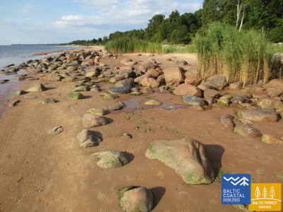
Maršruts piemērots visdažādāko vecumu un sagatavotības gājējiem. Līdz Zvejniekciemam pirmos kilometrus var iet pa pludmali, vai arī pārmaiņas pēc – pa taku, kas izlokas cauri kāpu mežam ar vecām priedēm, kurām raksturīga „krokodilādas” miza. Te redzama arī kāda veca zvejnieku tīklu un piederumu koka būda. Pirms Skultes ostas, Zvejniekciema liedagā parādās pirmie akmeņi. Apmetot līkumu Aģes grīvai un ostai, Jūrtaka atgriežas pludmalē, kur jau iztālēm redzams Ārņu rags, bet aiz tā – Lielā Lauču akmens brūnā mugura. Piekrastes ainavu daudzveidība.
 28. posms. Lauči - Tūja.
Aizgājušais burinieku laikmets
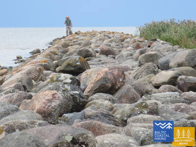
Izcili ainavisks Vidzemes krasta posms ar daudziem akmeņainiem zemesragiem un akmeņu „amfiteātriem” jūrā, kas mijas ar maziem, smilšainiem līcīšiem, kuros ietek mazu upīšu un urgu vasarā izsīkstošās tērcītes. Piemērots aktīviem gājējiem ar piemērotiem apaviem, jo vietām liedagu pilnībā klāj tikai akmeņu pelēkās muguras. Dažviet parādās arī nelieli niedru pleķīši, bet pie Tūjas – pirmie smilšakmens atsegumi.
29. posms. Tūja - Svētciems.
Vidzemes akmeņainā jūrmala
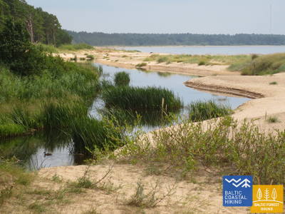
Maršruts piemērots aktīviem un izturīgiem gājējiem! Viens no skaistākajiem Jūrtakas posmiem, kas sākas ar Zaķupītes šķērsošanu. Līdz Ķurmraga bākai pārsvarā ir smilšaini liedagi ar nelieliem akmeņainiem posmiem. Tālāk sākas Vidzemes akmeņainā jūrmala, kur zemesragi mijas ar nelieliem līcīšiem, bet krastā paceļas līdz 4 m augsti smilšakmens atsegumi. Aiz Meleku raga atkal seko galvenokārt smilšains liedags, bet pirms Svētupes ietekas – stipri aizaugusi pludmale un niedrājs, kas apejams pa meža ceļu.
30. posms. Svētciems - Ainaži.
Nēģu karaliste
Daudzveidīgs Jūrtakas posms, kas piemērots aktīviem un izturīgiem gājējiem un putnu vērotājiem. Pludmale starp Svētciemu un Salacgrīvu ir stipri aizaugusi, tādēļ Jūrtaka iet pa meža ceļu, kas izvijas starp kāpu vaļņiem. No Salacgrīvas līdz Kuivižiem var doties pa smilšaino pludmali, vai arī pa meža takām. Randu pļavas no Kuivižiem līdz Vēverupei ir jāapiet pa meža ceļu, kas iet līdztekus A1 autoceļa austrumu pusē. Aiz Vēverupes Jūrtaka atgriežas stipri aizaugušā pludmalē, ko atkal pamet pie Blusupītes ietekas, lai tālāk pa Kāpu un Valdemāra ielu sasniegtu Ainažu molu. Latvijā ir veikti ap 580 km un sasniegta valsts robeža.