


Jūrtaka - Mazjūra

Mazjūra
Rīgas jūras līča Kurzemes piekraste
Kolka – Jūrmala: 115 km, 16.–20. diena
Par Mazjūru kurzemnieki sauc Rīgas jūras līča rietumu piekrasti. Mazjūras posms sākas Kolkasragā, Slīteres nacionālajā parkā, kuru šķērso Baltās – Baltijas jūras
putnu migrācijas ceļš. Jūrtaka ved gar Rīgas jūras līča piekrasti līdz pat Jūrmalai. Maršrutā ir daudz smilšainu liedagu, vietām piejūras pļavas, īsā posmā akmeņains
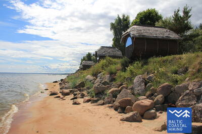
un maziem līcīšiem izrobots jūras krasts pie Kaltenes, kur vasaras laikā dzīvo gulbji. Piekrastē cits aiz cita izvietojušies mūsdienu zvejnieku ciemi un mazās jahtu ostas. Šeit notiek rūpnieciskā zveja, dažviet darbojas zivju pārstrādes uzņēmumi. Piekrastes ciemu tirdziņos, veikalos un pie zvejniekiem var nopirkt svaigi kūpinātas zivis.
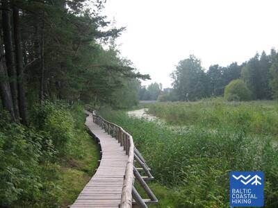
 16. posms. Kolka - Ģipka.
Gar "slēgto krastu"
Pagriežoties no Kolkasraga uz līča pusi, manāma atšķirība starp Dižjūru un Mazjūru. Jūrtakas pirmie 10 km ved pa Slīteres nacionālā parka piekrasti: sākumā gar jūrā ieskalotajām priedēm, gar kādreizējām zvejas kolhoza ēkām, kuģu piestātni un Ēvažu stāvkrastu, kura apkaimē ir neparasti šaurs, smilšains liedags ar tam pāri līkstošiem melnalkšņiem. Arī tālākajā posmā līdz Ģipkai raksturīgs šaurs, smilšains liedags ar bagātīgo avoksnāju veidotām lāmām un nelielu, vasarā – seklu upīšu ietekām. Slīteres krasts kādreiz bija divkārt slēgta teritorija – te bija pierobežas režīma zona un dabas rezervāts.
Lībiešu valodā Kolka senais nosaukums Kūolka, Melnsils / Mustānum un Ģipka / Gipk.
 17. posms. Ģipka - Kaltene.
Kurzemes akmeņainā jūrmala
No Ģipkas līdz Rojai stiepjas smilšaina, ne pārāk plata pludmale ar skaistām kāpām un piekrastes priežu mežiem, bet pirms Rojas – tā ir aizaugusi ar niedrēm. Savukārt, posms starp Roju un Kaltenes baznīcu ir savdabīgākais visā Latvijas piekrastē, kur jūras krasts ir izrobots ar maziem zemesragiem un līcīšiem ar ļoti šauru pludmali, kuru viscaur klāj dažādu izmēru laukakmeņu krāvumi, virs kuriem līkst melnalkšņu zaļā lapotne. Dažviet krastā slejas izskaloto koku plašās sakņu rozetes. Vietām gar pašu krastu iet zemes ceļš, gar kuru rindojas daudzas bijušās zvejnieku sētas. Maršruts piemērots aktīviem un izveicīgiem gājējiem!
Lībiešu valodā Ģipka senais nosaukums Gipk.
18. posms. Kaltene - Mērsrags.
Daudzveidīgais krasts
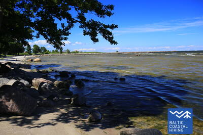
Maršruts piemērots aktīviem un izveicīgiem gājējiem! Dabas, kultūrvēstures pieminekļu un ainavu ziņā – ļoti daudzveidīgs Jūrtakas posms. Pie Kaltenes jūras krastu izraibina nelieli līcīši ar akmeņainām pludmalēm, bet tālāk seko ļoti aizaudzis jūras krasts, kur starp niedrēm un bagātīgi sazēlušo augāju iemīta šaura taciņa. Tālāk akmeņiem klātais jūras krasts ir tikai dažus metrus plats, vietām ar māla slāņiem, niedru laukiem, citviet ar izskalotajām aļģēm klāts. Posmā no Valgalciema līdz Mērsragam atkal parādās smilšaini liedagi ar sēkļiem jūrā. Aiz Mērsraga maršruts turpinās pa ceļu, bet pie luterāņu baznīcas – nogriežas uz jūras pusi un līdz pat Mērsraga centram iet gar Piejūras pļavu.
19. posms. Mērsrags - Engure.
Engures dabas parkā
Maršruts piemērots aktīviem gājējiem. No ciema centra līdz pludmalei aizved meža ceļs, ko ieskauj priežu mežs. Tālāk Jūrtaka ved pa takām, kas izlokas starp niedrēm un citiem zālaugiem bagātīgi apaugušo un akmeņaino jūras krastu vienā un mežainām jūrmalas kāpām – otrā pusē. Dažviet liedags ir nobruģēts ar maziem, apaļiem akmeņiem, citur redzamas pelēkās kāpas ar bagātīgu augu sugu klāstu. Bērzciema apkaimē plešas piejūras pļavas ar sēkļiem tālu jūrā, kas ir laba putnu vērošanas vieta. Līdz Abragciemam turpinās aizaugušais jūras krasts, bet no Abragciema līdz Engurei ir liedags.
 20. posms. Engure - Ragaciems.
Zvejniekciemi un kūpinātas zivis
Maršruts, kura pēdējā trešdaļa atrodas Ķemeru nacionālajā parkā, piemērots aktīviem gājējiem. Sākotnēji Jūrtaka izvijas cauri Engures ciemam, tad pa salīdzinoši šauru liedagu vienā pusē un skaistām mežainām jūrmalas kāpām otrā pusē aizved līdz Plieņciema kāpai, kur tālākajā posmā smilšainais liedags kļūst aizvien plašāks, bet jūrā parādās plaši sēkļi. Sauszemes virzienā šeit paceļas apauguši stāvkrasti ar kāpnēm un labiekārtotām laipām līdz Kolkas - Tukuma autoceļam. Jārēķinās, ka siltās vasaras dienās šeit ir daudz atpūtnieku.