


Jūrtaka - Kuršu lagūna

Kuršu lagūnas piekraste
Piekrastes ainavas, zvejnieku ciemi un Klaipēda
Ventė – Dreverna – Klaipėda: 50 km, 2 dienas.
Ventes (Ventė) ragā atrodas putnu gredzenošanas stacija ar nelielu bāku, no kuras var redzēt Kuršu līča jeb Kuršu jomas ūdeņus. Piekrastes ciemos attīstās tūrisma infrastruktūra, jo šīs vietas iecienījuši kaitotāji. Jūrtaka izlokās cauri Drevernai – kādreizējam zvejnieku ciemam, kur atrodas jahtu osta un kempings. Tālāk tā 10 km garumā virzās gar industriālā mantojuma būvi - Karaļa Vilhelma kanālu, ko būvēja 19.gs. 60-70-ajos gados, nosaucot par godu tālaika Vācijas ķeizaram Vilhelmam Pirmajam. No Klaipēdas (Klaipėda) ar prāmi var pārcelties uz Kuršu kāpām, kur atrodas apmeklētāju iecienītais Jūras muzejs un Delfinārijs. Klaipēda savulaik ietilpa Austrumprūsijā un atradās vācu kultūras ietekmē, tās vēsturiskais nosaukums ir Mēmele. Klaipēdas vecpilsētas plānojums atšķiras ar ģeometrisku precizitāti, kur visi krustojumi ir 90 grādu leņķī.
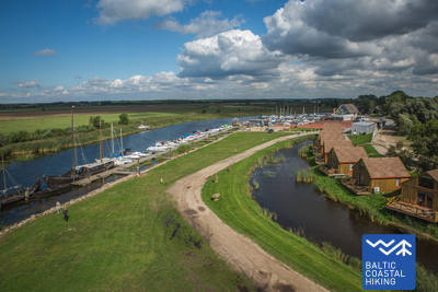
 72. posms. Ventė – Dreverna.
Gar Kuršu jomas (līča) austrumu krastu
No Ventes raga Jūrtaka pa Marių ielu (ceļš Nr. 2201) dodas Klaipēdas virzienā. Piekrastes ainavu atdzīvina krāsainās ēkas ar bagātīgiem koka rotājumiem. Dažās no tām ir iekārtotas naktsmītnes un ēdināšanas vietas. Pēc 5 km Jūrtaka nogriežas Kuršu jomas (līča) virzienā un turpinās pa mazu piekrastes taku, ko ieskauj mitrie dumbrāju meži. Šeit ir atpūtas vietas un skatu torņi, no kuriem paveras skaistas ainavas uz 8–10 km attālajiem Kuršu kāpas smiltājiem. Izmetusi ap 3 km garu loku, Jūrtaka iznāk uz iepriekšējā ceļa un pēc aptuveni 2 km sasniedz Kintu ciema centru, kur vērts iepazīt arhitektūras mantojumu. Aiz Kintiem Jūrtaka 5 km garumā šķērso skaistu, priedēm noaugušu mežainu kāpu masīvu. 3 km pirms Drevernas ciema Jūrtaka šķērso Svenceli, kas ir populārākā Lietuvas vindsērfinga un kaitsērfinga vieta. Šeit notiek jaunu, alternatīvu tūristu mītņu, kempingu un ēdināšanas vietu būvniecība un kūrorta attīstība. Drevernas ciemā Jūrtaka nogriežas pa Bangų ielu. Šeit ir vērts aiziet līdz Drevernas ostai, no kurienes atkal var palūkoties pāri Kuršu jomai uz vareno Kuršu kāpu.
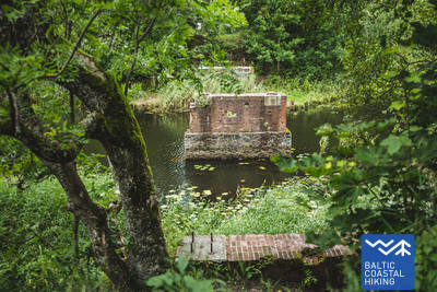
 73. posms. Dreverna – Klaipėda.
Gar Karaļa Vilhelma kanālu uz Klaipēdu
No Drevernas ciema Jūrtaka pa Priekulė ceļu (Nr. 2206) šķērso Drevernas upi, Klišupė un Karaļa Vilhelma kanālu, aiz kura pagriežas pa kreisi un turpmāko 9 km garumā kā koku lapotnes aizsegta aleja virzās gar vēsturiskā kanāla austrumu krastu. Vietām šeit ierīkotas atpūtas vietas un tūrisma informācijas stendi, kas vēsta par apkaimes dabas daudzveidību. Vēl pēc 4 km Jūrtaka sasniedz Kairių ielu, un tālākais posms ved pa pilsētvidi. No Jūrininkų prospekta līdz Baltijos prospektam Jūrtaka virzās cauri pilsētas parkiem, šķērsodama Sąjūdžio, Reikjaviko, Draugystės u.c. parku takas. Šķērsodama Baltijos prospektu, tā tālāk ved pa Taikos prospekta gājēju ietvēm un pēc 3 km sasniedz Biržas tiltu.