


Metsa matkarada - Valley Dubysa river

Dubysa jõe orus
Dubysa jõe oru kallastel
Vilkija – Dengtiltis: 141 km, 6 või 7 päeva.
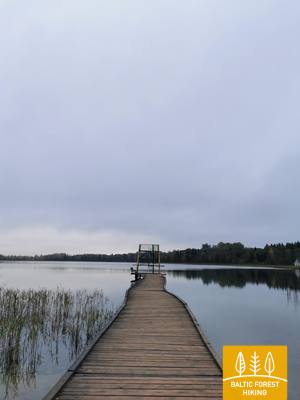
Järgmised poolteist päeva kulgeb Metsa matkarada läbi Dubysa regionaalpargi, kus Dybusa jõe kaldaid ilmestavad linnamäed, ajaloolised kirikud ja muud ajaloolis-kultuurilised mälestised. Dybusa on maaliline jõgi, mis meeldib loodussõpradele eeskätt oma kiire voolu tõttu. Jõgi on madal, vesi selge ning liivastel kallastel on mitmeid puhke- ja telkimisplatse. Metsa matkarada viib läbi Betygala, Ugioniuse ja Šiluva külade, kuni jõuab Tytuvėnai regionaalparki. Selle pargi suurimad väärtused on järved ja nende vahelised märgalad, mis on olulised elupaigad paljudele looma- ja linnuliikidele, sealhulgas tuhandetele sookurgedele. Tytuvėnai linn on tuntud oma barokkstiilis frantsiskaani kloostri ja kiriku poolest, mis on rajatud 17. sajandil. Šiluva on oluline koht katoliiklaste jaoks, sest see on palverännakute sihtkoht.
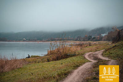
 67. päev. Vilkija – Padubysys.
Kahe jõeoru – Nemunase ja Dubysa – vahel
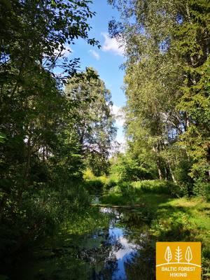
Metsa matkaraja esimene kilomeeter kulgeb otse Nemunase kaldal, pöörab siis Kaunase–Jurbarkase teele (nr 141) ja jätkub kergliiklusteel kuni Ringovė linnamäeni. Keerates põhja poole, läbib matkarada väikese metsamassiivi (entomoloogiline ehk putukate kaitseala) ja siirdub teele nr 1929. 2 km pärast keerab Metsa matkarada vasakule ja teekond kulgeb läbi põllumajandusmaastiku. Enne Lazduoniai küla ületab rada Lazduona jõe sügava oru ja keerab õige pea paremale, loode suunas, kuni jõuab Dybusa jõe laia ja sügavasse orgu. Järgmised 2 km mööduvad Dubysa vasakkalda käänulisel külavaheteel, siin-seal on näha mõni üksik talukoht. Suvel on jõevesi selge, vool tasane ja voolu takistavad vaid mõne vana veskikoha varemed. Lõpuks keerab Metsa matkarada üles Dubysa oru kõrgele kaldale ja jõuab teekonna lõpp-punkti.
 68. päev. Padubysys – Ariogala – Kirkšnovė.
Teel ühe Leedu vanima asulakohani – Ariogala
Keerutades Dubysa oru järskudel nõlvadel, läbib Metsa matkarada 2,5 km ulatuses väikse metsa ja jõuab 4 km pärast Čekiškė külla. Suvel laiuvad tee ääres suured maisipõllud. Järgmised 4 km on maastik üsna sarnane, kuniks rada ületab jalakäijate silla kaudu Kaunase–Klaipėda maantee (A1). Umbes 1,5 km pärast, enne Gėluva küla, laskub Metsa matkarada sügavale Dubysa orgu ja tiirleb jõe lookeid järgivatel väikestel külavaheteedel. Rajalt avanevad head vaated oru nõlval asuvale Ariogala linnale. Mööda Dubysose ja Gedimino tänavaid jõuab rada linnakese kesktänavale (Vytauto tn). Teekond jätkub Plento tänaval, mis viib linnast välja, päevateekonna sihtpuntki ehk 5 km kaugusel oleva Krikšnovė tiigi juurde.
69. päev. Kirkšnovė – Kaulakiai.
Dubysa regionaalpargis
Umbes pool kilomeetrit pärast alguspunkti Kirkšnovės keerab Metsa matkarada Ariogala–Betygala teelt (nr 3504) vasakule, kuni jõuab Raseiniai–Baisogala teeni (nr 225), mis lookleb Dybusa jõe käänulistel kallastel. Siin vahelduvad lamminiidud väikeste metsatukkade ja väikeküladega. Mõnes kohas avanevad pikad vaated Dubysa oru kõrgetele kallastele ja linnamägedele. Reljeef on mitmekesine: Metsa matkarada keerleb järskudel nõlvadel üles-alla ning tekitab tõelise matkamise tunde. See lõik on iga matkasõbra maiuspala!
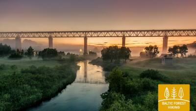
70. päev. Kaulakiai – Šiluva.
Dubysa org ja Leedu kõrgeim raudteesild
Raseiniai–Baisogala maantee (nr 225) kõnniteel kulgedes läbib Metsa matkarada Dubysa jõe sügava oru ja keerab Ginčaičiai külas paremale. Nüüd suundub rada läbi ümbritseva kultuurmaastiku, kuni jõuab 6 km pärast Raseiniai–Šiluva teele (nr 148). Umbes 3 km hiljem laskub rada taas Dubysa orgu ja jõuab Kušeliškė külla. Järgmised 5,5 km mööduvad Kušeliškė–Lyduvėnai teel (nr 3516). Kuulus ja maaliline Lyduvėnai raudteesild on juba kaugelt näha. Veidi enne Dubysa maanteesilda keerab Metsa matkarada paremale, kirde suunas ja jätkub teel nr 3544, kuni jõuab 9 km pärast Šiluva linnapiirini. Siit on kesklinna veel veidi all kilomeetri. Selles lõigus muutub reljeef künklikumaks, kuna Dybusa jõe madalik läheb järk-järgult üle Ida-Žemaitija kõrgustikuks. Lyduvėnai sillani kulgev lõik kulgeb osaliselt Dubysa regionaalpargis või selle lähedal, kuid Šiluva jääb juba Tytuvėnai regionaalpargi territooriumile.
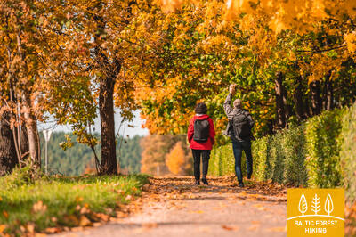
71. päev. Šiluva – Tytuvėnai – Aukštiškiai.
Läbi Tytuvėnai regionaalpargi
Šiluva ja Tytuvėnai vahel kulgeb Metsa matkarada 7 km ulatuses kergliiklusteel. Rada suundub Šiluvose ja Maironio tänavaid mööda Tytuvėnai keskusesse, keerab Miško tänavale ja jätkab teekonda Giliuse järve maalilisel läänekaldal. Järve põhjakaldale jõudes käänab rada itta vanale raudteetammile ja jõuab u 1,4 km pärast Kuršių tänavale. U 600 meetri pärast, enne Budraičiai küla tuleb võtta suund vasakule, läände. Päevateekonna lõpp-punkti – Aukštiškiaisse – jääb siit veel umbes 4 km jagu kruusateed.
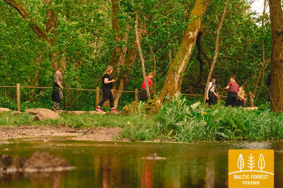
72. päev. Aukštiškiai – Dengtiltis.
Läbi maalilise Šimša metsa
See rajalõik suundub Ida-Žemaitija kõrgustikule, mida tuntakse ka Ida-Samogitia kõrgustikuna. Metsa matkarada kulgeb 5 km pikkuselt põllumajandusmaastikus, ületab Šiauliai–Tauragė raudtee ja jõuab väikseid metsateid pidi Tytuvėnai regionaalpargi Šimša metsas asuvasse Kiaunoriai külla. Rada viib piki külakese peatänavat (Draugystėse tn), kuni keerab u 500 meetri pärast vasakule, loodesse (tee nr 2122), et suunduda 4 km kaugusel asuva Pašiaušė küla poole. Veel 4 km hiljem laskub Metsa matkarada Dubysa orgu ja keerab vasakule, kus lookleb edasi jõe paremal kaldal. Umbes poole kilomeetri pärast ongi päeva lõpp-punkt – Dengtiltis. Dengtiltis asub Kurtuvėnai regionaalpargis, kus kulgeb ka kogu järgmise päeva teekond.