


Metsa matkarada - Kaunas

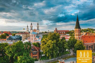
Kaunas ja Kaunase piirkond
Kahe jõe kohtumispaigas asuvad maalilised linnad, mida ümbritseb rohelus ja kahe sõja vaheline arhitektuur
Pakuonis – Vilkija: 79 km, 5 päeva.
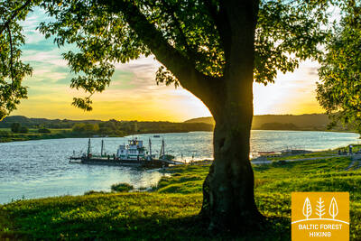
Kaunas, üks kõige ilusamaid Leedu linnu, asub Nemunase ja Nerise jõgede kohtumispaigas. Kaunas on Leedu suuruselt teine linn. See oli kunagise Vene Impeeriumi (1842–1915) Kovno kubermangu pealinn ja kahe maailmasõja vahelisel perioodil Leedu pealinn (1919–1940). Kaunase suurim park on Panemunėse männik. Seal on rohkesti jalgrattateid ja teeradu ning Nemunase kallastel on supelrannad. Lampėdise karjäär (125 ha) oli vanasti kruusakarjäär. Selle kaldad on nüüd Kaunase rahvale mõnus ajaveetmis- ja supluskoht. Metsa matkarada teeb põike läbi Kulautuva kuurortlinna. Kergliiklustee viib piki Nemunase kallast kuni Vilkijani ning matkajale avanevad kaunid vaated jõele. Teel Vilkijasse toob vaheldust mitmekesine maastik, mida iseloomustavad väikeasulad, linnamäed ja metsatukad.
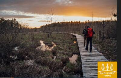
 62. päev. Pakuonis – Vaišvydava.
Läbi Kaunase veehoidla regionaalpargi
Pakuonise linnast suundub Metsa matkarada Kaunase tänavat kaudu loode ja põhja suunas ning jõuab 7 km pärast Piliuona linna. Seejärel kulgeb rada piki Nemunase tänavat ja keerab umbes 1,6 km järel vasakule, Dubravai suunas. Nüüd siirdub matkarada metsa vahele, kuni jõuab u 2,4 km pärast Dubravai külla. Vaišvydava küla, kus asub päevateekonna lõpp-punkt ja Kaunase veehoidla regionaalpargi külastuskeskus, jääb siit veel 3 km kaugusele.
63. päev. Vaišvydava – Kaunas.
Läbi Kaunase parkide
Kaunase veehoidla regionaalpargi külastuskeskusest viib Metsa matkarada läbi Rokų metsa ja piki Miškininkų, Kelmyno, Muraškinėse, Žarstose, Garšvėse ja Rokelių tänavaid Kaunase kesklinna suunas. Veidi aega tiirutab rada Kaunase eeslinnades, ületab Marijampolė maantee (nr 139) suundub Balčkalnio tänava kaudu Panemunė linnaosasse. Kaunase Tehnikaülikooli staadioni juurest laskub rada Vaidoto tänavale, jätkab teekonda Baterijose maantee ääres oleval kõnniteel, kuni keerab vasakule. Umbes kolmandik Kaunase linna pindalast on kaetud parkide ja teiste looduslike aladega. Metsa matkarada kulgeb läbi linna kõige rohelisemate alade. Umbes 2,5 km pikkuselt lookleb rada Panemunė männikus, kus on arvukalt teeradu, puhkealasid ja isegi supelrand. Nüüd ületab Metsa matkarada Kolme Neitsi silla kaudu Nemunase jõe, kulgeb läbi Gričiupise linnaosa, mööda Kaunase loomaaiast, läbib uhke Ąžuolynase tammiku ning jõuab Leedu Spordiülikooli taha asuvasse Vytauto parki. Pargist laskub rada mööda treppi Vabaduse puiesteele (Laisvės Alėja) ning suundub kindlalt Kaunase kesklinna.
TÄHTIS. Kaunase linna läbivatel lõikudel märgistus puudub.
64. päev. Kaunas – Lampėdžiai.
Läbi Kaunase ajaloolise kesklinna
Kaunas on Leedu suuruselt teine linn. 1621 meetri pikkune Vabaduse puiestee (Laisvės Alėja) paistab silma omapärase modernistliku arhitektuuri poolest: siinsed 1914.–1940. aastail ehitatud hooned on pälvinud Euroopa Pärandi märgi. Vilniuse tänav on „värav“ keskaegsesse Kaunasesse, mida juhtisid Hansa Liidu kaupmehed. Metsa matkaraja äärde jäävad Kaunase vanalinna kirikud, Raekoja plats ja arvukad ajaloolised hooned. Rada teeb looke Santakose pargis, kus kohtuvad Leedu kaks suurimat jõge, Nemunas ja Neris. Matkarada ületab Nerise jõe ning suundub kergliiklusteid pidi 4 km kaugusel asuva Lampėdise kruusakarjääri juurde. Karjääri on rajatud tehisjärv ning see on kohalike seas armastatud puhke- ja supluskoht.
TÄHTIS. Kaunase linna läbivatel lõikudel märgistus puudub.
65. päev. Lampėdžiai – Kulautuva.
Nemunase kallastel
Esimesed 2 km kulgeb Metsa matkarada Lampėdise karjääri põhjakaldal ning jõuab seejärel suurele maanteele. Mööda kõnniteed Raudondvare suunas siirdudes ületab rada Nevėžise jõe. Poole kilomeetri pärast keerab rada vasakule, Pakalnėse tänavale ning jõuab taas Nemunase paremkaldale, kus väiksed rajad viivad matkaja piki jõekallast üha edasi. Jõekallastel on näha kääpaid. Pärast Šilelise küla suundub Metsa matkarada kergliiklusteed mööda Kulautuva väikelinna, põigates mõneks ajaks ka väiksele metsarajale. Piki Pušyno ja V. Augustausko tänavaid jõuab rada päevateekonna lõpp-punkti.
TÄHTIS. Kaunase linna läbivatel lõikudel märgistus puudub.
66. päev. Kulautuva – Vilkija.
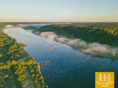
Nemunase lamminiitudel
Kogu sellel lõigul kulgeb Metsa matkarada Nemunase paremkalda metsa- ja külavaheteedel. Matkajat rõõmustavad kaunid vaated jõele, lamminiitudele ja väikestele küladele jõe kaldal. Päeva lõpp-punkt – Vilkija parvesadam – paistab Nemunase kaldal juba kaugele. Sadama lähedal on Vilkija väikelinna keskus koos kirikuga. Suve teisel poolel on Nemunase jõe niidud kaetud siniste ja kollaste lilledega. Kindlasti võiks varuda aega, et sõita parvega vastaskaldale ja tagasi, sest selliseid üleveoparvi on Balti riikides säilinud vaid väga vähestes kohtades.